Showing 1281 items matching "victorian maps"
-
 Bendigo Military Museum
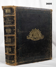
Book - BOOK WW1, The All Australia Memorial, 1917
The All Australian Memorial (Victorian Edition) A Historical Record of National Effort During The Great War. Australians Roll of Honour 1914 - 1916, Heroes and Helpers.Hard cardboard cover, black buckram, gold print on front & spine. Australian Military Forces badge illustrated on front. 158 cut, gold page edges, beige paper. Black / white / sepia photos, drawings, maps, portraits, etc. Many photos mounted on cardboard mounts. Fold out photos & maps. Fly leaf & end papers are dark green. Some photos missing. Inscription stamp.Inscription on front end paper handwritten in blue ink: “Desmond V B?er 146 Queen Street Bendigo” Title page: “RSL stamp”book, memorial, all australian -
 Federation University Historical Collection
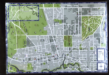
Map, Sebastopol (Delacombe, Redan and Ballarat South) Retail and Business Guide, 2005, 10/2005
Sebasgtopol is a suburb of Ballarat.Sebastopol, Delacombe, Redan and Ballarat South and business guide map.map, guide, delacombe, redan, ballarat south, victorian park, bray raceway, sebastopol equestrian centre, western oval, city oval -
 Federation University Historical Collection
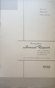
Booklet - Annual Report, Greater Ballarat Association Annual Report 1952-1974, 1952-1974
The first presedent of the Greater Ballarat Association in 1938 was Robert J. Cooke. Eighteen annual reports of the Greater Ballarat Association. Each one discussed the work of the association and lists the subscribers. greater ballarat association, annual report, edgar bartrop, g.b. richmond, a.w. nicholson, g.e. deeble, r.g> caddell, l.j. fraser, t.u. haymes, a.w. lynch, keith rash, tourist bureau, botanical gardens telepone booth, pryor park tree planting, ballarat zoological gardens, centenary window dressing competition, soldier settlement, proposal for university for ballarat, caravan park, ballarat common, ballarat common development, t.t. hollway, housing commission, wendouree housing commission, industrial development, s.s. ballarat, begomia festiva, r.g. caddell, w.gordon smith, f.h. menzies, olympic rowing, royal tour decorations, begonia float, widening of railway bridge, j. chatham, l.g. chester, s.v. playsted, n. ellis, langi kal kal, langi kal kal training centre, migrants to victoria, flood lighting of the arch of victory, olympics holidays, ballarat's projected olympic pool, ballarat fish hatcheries, olympic hostel, town planning, murray byrne, titles for residence areas, service club signs, railway level crossing, traffic, ploughing competition, w. fraser, young australia league, removal of raaf from ballarat, renumbering of streets, renumbering of streets to the block system, miners' racecourse reserve, historical museum, ballarat historical society, c.m. canty, mavis canty, university status, ballarat university college, j.w. murray, p.r. gray, b.c. mcorist, n.c. ellis, w.h. heinz, save the lake campaign, lake wendouree, weed, home host scheme, b. walker, develop victoria council, eureka development, victorian decentralization league, r.h. ramsay, allan c. pittard, w. gordon smith, c.h. davis, b.c. hedgcock, les kennedy, p.j. rice, a.f. waddington, john p. cook, historic markers, maze, traffic lights, bungal dam, camera clubs, sunraysia way, map, centre of road parking, paddle steamer, wendouree apex, local government women's association, may nelson, wes sobey, melton foo, l.l. zilles, dulcie sullivan, m. barnes, lou zilles, john wesley sobey, e.r. ingles, herb warren, kryal castle -
 Federation University Historical Collection
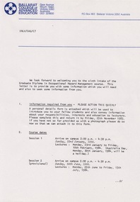
Document - Document - Information, VIOSH: Graduate Diploma in Occupational Hazard Management - Intake 6, 1984, Information Letter to students
Victorian Institute of Occupational Safety and Health (VIOSH) Australia is the Asia-Pacific centre for teaching and research in occupational health and safety (OHS) and is known as one of Australia's leaders on the field. VIOSH has a global reputation for its innovative approach within the field of OHS management. VIOSH had its first intake of students in 1979. At that time the Institution was known as the Ballarat College of Advanced Education. In 1990 it became known as Ballarat University College, then in 1994 as University of Ballarat. It was 2014 that it became Federation University. VIOSH Australia students are safety managers, senior advisors and experienced OHS professionals. They come from all over Australia and industry. Students are taught active research and enquiry; rather than textbook learning and a one-size fits all approach. VIOSH accepts people into the Graduate Diploma of Occupational Hazard Management who have no undergraduate degree - on the basis of extensive work experience and knowledge. Information letter sent to those in Intake 6 of the Graduate Diploma of Occupational Hazard Management Course, 1984. It outlines the timetable for subjects and times at the Ballarat College of Advanced Education. Include in the package is a form that must be completed and returned ASAP. Residences are provided and items included are listed. Transport for those coming from interstate can be arranged. Derek Viner is the Course Co-ordinator.Twenty-three A4 pages, typed with diagrams, mapsHand written note in blue pen on map. Letter head of Ballarat College of Advance Education on some pages. Signature of Derek Viner, Course Co=ordinator.viosh, victorian institute of occupational safety and health, derek viner, course co-ordinator, occupational hazard management, residence, timetable, ballarat college of advanced education -
 Federation University Historical Collection
Book - Astronomy, Richard A. Proctor, Other Worlds Than Ours: The Plurality of Worlds Studied under the Light of Recent Scientific Researches, 1878
Richard Anthony Proctor (23 March 1837 – 12 September 1888) was an English astronomer who produced one of the earliest maps of Mars in 1867 from 27 drawings by the English observer William Rutter Dawes. He used old drawings of Mars dating back to 1666 to try to determine the sidereal day of Mars. His final estimate, in 1873, was 24h 37m 22.713s, very close to the modern value of 24h 37m 22.663s. Proctor was already a well-known populariser of science when he published this book, joining a ferocious debate about the possibility of life on other planets. The crater Proctor on Mars is named after him.Red hard covered book of 318 pages. Includes early images of planets as seen through a J. Browning Telescope. Proctor discusses Victorian discoveries about the solar system and describes what was then known about each of the planets. He evaluates the habitability of Mars, Jupiter, Mercury, Venus and Saturn in the light of his belief in the possibility of extraterrestrial life. The text includes many illustrations of the planets, a spectacular map of Mars, and theoretical views of the Milky Way. Influenced by Darwin, Proctor had a teleological view of the universe and believed that eventually the cosmos would be filled with living things. non-fictionRichard Anthony Proctor (23 March 1837 – 12 September 1888) was an English astronomer who produced one of the earliest maps of Mars in 1867 from 27 drawings by the English observer William Rutter Dawes. He used old drawings of Mars dating back to 1666 to try to determine the sidereal day of Mars. His final estimate, in 1873, was 24h 37m 22.713s, very close to the modern value of 24h 37m 22.663s. Proctor was already a well-known populariser of science when he published this book, joining a ferocious debate about the possibility of life on other planets. The crater Proctor on Mars is named after him.astronomy, planets, telescope, earth, sun, jupitar, saturn, uranus, neptune, moon, meteors, comets, solar system, nebulae, galaxies, milky way -
 Wycheproof & District Historical Society Inc.
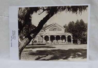
Photograph, Wycheproof Court House, (estimated); mid to late 19th century
The Court House opened as a court of petty sessions in 1890 and closed as a court in the early 1980s. It is now a 'Place of Deposit' for paper based products, maps, documents and photographs, and the home of the Wycheproof and District Historical Society Inc. The local Craft Group met at the Court House between 1982 and 2010. The Buloke Shire Council oversees the maintenance of the building.The Court House is No H 1656 on the Victorian Heritage Register. It is the one of only two buildings with this listing in Wycheproof, and characteristic of the type of building constructed in the early days of settlement in Wycheproof. The architecture is of aesthetic value and although some restoration work has taken place to maintain the structure, it remains in good condition and with some of the original furnishings intact.Sepia print of the Wycheproof-Court-House. It was constructed during 1889/90 and commissioned on September 23,1890 as a court-of-petty-sessions. A simple form of Court House built of red-face-brick but embellished by stepped brick work in the principal gable and by the traverse veranda with elaborate frieze and gabled pavilions that protect the street facade. The roof is of slate.Nonecourt house, wycheproof heritage 1890, petty sessions, building, red face brick, gabled pavilions -
4th/19th Prince of Wales's Light Horse Regiment Unit History Room
Map, Victoria, 3rd Military District, 3rd and 5th Brigades of 2nd Cavalry Division, 1 January 1921
... Coloured print of map (2 copies) showing Victorian Light... print of map (2 copies) showing Victorian Light Horse regimental ...The 4th/19th Prince of Wales's Light Horse Regiment is now the only Victorian Light Horse Regiment and the custodian of the histories of the six Light Horse regiments depicted on the mapColoured print of map (2 copies) showing Victorian Light Horse regimental areas of 3rd and 5th Brigades of 2nd Cavalry Division. 5th Brigade: 4th, 19th, & 17th Light Horse Regiments 3rd Brigade: 20th, 8th & 13th Light Horse RegimentsIssued by authority of the District Commandant -
 Flagstaff Hill Maritime Museum and Village
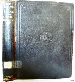
Book, The Outline of History Vol 1
This item is from the ‘Pattison Collection’, a collection of books and records that was originally owned by the Warrnambool Mechanics’ Institute, which was founded in Warrnambool in 1853. By 1886 the Warrnambool Mechanics’ Institute (WMI) had grown to have a Library, Museum and Fine Arts Gallery, with a collection of “… choice productions of art, and valuable specimens in almost every branch and many wonderful national curiosities are now to be seen there, including historic relics of the town and district.” It later included a School of Design. Although it was very well patronised, the lack of financial support led the WMI in 1911 to ask the City Council to take it over. In 1935 Ralph Pattison was appointed as City Librarian to establish and organise the Warrnambool Library as it was then called. When the WMI building was pulled down in 1963 a new civic building was erected on the site and the new Warrnambool Library, on behalf of the City Council, took over all the holdings of the WMI. At this time some of the items were separated and identified as the ‘Pattison Collection’, named after Ralph Pattison. Eventually the components of the WMI were distributed from the Warrnambool Library to various places, including the Art Gallery, Historical Society and Flagstaff Hill. Later some were even distributed to other regional branches of Corangamite Regional Library and passed to and fro. It is difficult now to trace just where all of the items have ended up. The books at Flagstaff Hill Maritime Village generally display stamps and markings from Pattison as well as a variety of other institutions including the Mechanics’ Institute itself. RALPH ERIC PATTISON Ralph Eric Pattison was born in Rockhampton, Queensland, in 1891. He married Maude Swan from Warrnambool in 1920 and they set up home in Warrnambool. In 1935 Pattison accepted a position as City Librarian for the Warrnambool City Council. His huge challenge was to make a functional library within two rooms of the Mechanics’ Institute. He tirelessly cleaned, cleared and sorted a disarrayed collection of old books, jars of preserved specimens and other items reserved for exhibition in the city’s museum. He developed and updated the library with a wide variety of books for all tastes, including reference books for students; a difficult task to fulfil during the years following the Depression. He converted all of the lower area of the building into a library, reference room and reading room for members and the public. The books were sorted and stored using a cataloguing and card index system that he had developed himself. He also prepared the upper floor of the building and established the Art Gallery and later the Museum, a place to exhibit the many old relics that had been stored for years for this purpose. One of the treasures he found was a beautiful ancient clock, which he repaired, restored and enjoyed using in his office during the years of his service there. Ralph Pattison was described as “a meticulous gentleman whose punctuality, floorless courtesy and distinctive neat dress were hallmarks of his character, and ‘his’ clock controlled his daily routine, and his opening and closing of the library’s large heavy doors to the minute.” Pattison took leave during 1942 to 1945 to serve in the Royal Australian Navy, Volunteer Reserve as Lieutenant. A few years later he converted one of the Museum’s rooms into a Children’s Library, stocking it with suitable books for the younger generation. This was an instant success. In the 1950’s he had the honour of being appointed to the Victorian Library Board and received more inspiration from the monthly conferences in Melbourne. He was sadly retired in 1959 after over 23 years of service, due to the fact that he had gone over the working age of council officers. However he continued to take a very keen interest in the continual development of the Library until his death in 1969. The Pattison Collection, along with other items at Flagstaff Hill Maritime Village, was originally part of the Warrnambool Mechanics' Institute’s collection. The Warrnambool Mechanics’ Institute Collection is primarily significant in its totality, rather than for the individual objects it contains. Its contents are highly representative of the development of Mechanics' Institute libraries across Australia, particularly Victoria. A diversity of publications and themes has been amassed, and these provide clues to our understanding of the nature of and changes in the reading habits of Victorians from the 1850s to the middle of the 20th century. The collection also highlights the Warrnambool community’s commitment to the Mechanics’ Institute, reading, literacy and learning in the regions, and proves that access to knowledge was not impeded by distance. These items help to provide a more complete picture of our community’s ideals and aspirations. The Warrnambool Mechanics Institute book collection has historical and social significance for its strong association with the Mechanics Institute movement and the important role it played in the intellectual, cultural and social development of people throughout the latter part of the nineteenth century and the early twentieth century. The collection of books is a rare example of an early lending library and its significance is enhanced by the survival of an original collection of many volumes. The Warrnambool Mechanics' Institute’s publication collection is of both local and state significance. The Outline of History Vol 1 Being a Plain History of Life and Mankind with maps & Plans by J. F. Horrabin Author: H G Wells Publisher: Waverley Book Co Ltd Date: 1925Label on spine cover with typed text PAT F 909 WEL Pastedown front endpaper has sticker from Warrnambool Public Library covered by a sticker from Corangamite Regional Library Service Front loose endpaper has a stamp from Corangamite Regional Library Service Fly paper has a stamp from Corangamite Regional Library Servicewarrnambool, shipwrecked-coast, flagstaff-hill, flagstaff-hill-maritime-museum, maritime-museum, shipwreck-coast, flagstaff-hill-maritime-village, shipwrecked-artefact, book, pattison collection, warrnambool library, warrnambool mechanics’ institute, ralph eric pattison, corangamite regional library service, warrnambool city librarian, mechanics’ institute library, victorian library board, warrnambool books and records, warrnambool children’s library, great ocean road, h g wells, the outline of history vol 1 -
 Flagstaff Hill Maritime Museum and Village
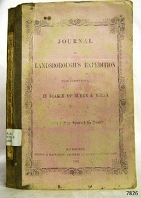
Book, Journal of Landsboroughs Expedition
WARRNAMBOOL MECHANICS’ INSTITUTE Warrnambool's Mechanics' Institute (or Institution as it was sometimes called) was one of the earliest in Victoria. On 17th October 1853 a meeting was held where it was resolved to request the Lieutenant Governor of the Colony to grant land for the erection of a Mechanics' Institutes building. A committee was formed at the meeting and Richard Osburne chaired the first meeting of this committee. The land on the North West corner of Banyan and Merri Streets was granted but there were no funds to erect the building. The Formal Rights of the Warrnambool Mechanics' Institute's encompassed its aims and these were officially adopted in1859; "This Institution has for its object the diffusion of literary, scientific, and other useful knowledge amongst its members, excluding all controversial subjects, religious or political. These objects are sought to be obtained by means of a circulating library, a reading room, the establishment of classes, debates, and the occasional delivery of lectures on natural and experimental philosophy, mechanics, astronomy, chemistry, natural history, literature, and the useful and ornamental arts, particularly those which have a more immediate reference to the colony." The Warrnambool Mechanics' Institute opened its first reading room in November1884 in the National School building at the corner of Banyan and Timor Streets. The Institute was funded by member subscription, payable on a quarterly, half yearly or yearly basis. Samuel Hannaford, the Manager of the Warrnambool Bank of Australasia, was the first Honorary Secretary of the Mechanics' Institutes, and an early President and Vice-President. He also gave several of the early lectures in the Reading Room. Another early Secretary, Librarian and lecturer was Marmaduke Fisher, the teacher at the National School. Lecture topics included The Poets and Poetry of Ireland', 'The Birth and Development of the Earth', 'The Vertebrae - with Remarks on the pleasures resulting from the study of Natural History' and 'Architecture'. In 1856 the Reading Room was moved to James Hider's shop in Timor Street, and by 1864 it was located in the bookshop of Davies and Read. In the 1860's the Mechanics' Institute struggled as membership waned but in 1866, after a series of fund raising efforts, the committee was able to purchase land in Liebig Street, on a site then called Market Square, between the weighbridge and the fire station. A Mechanics' Institute building was opened at this site in August 1871. The following year four more rooms were added to the main Reading Room and in 1873 the Artisan School of Design was incorporated into the Institute. The same year Joseph Archibald established a Museum; however it deteriorated when he was transferred to Bendigo in 1877. In 1880, with Archibald's return to Warrnambool, the Museum was re-established, and in 1885 a new building was built at the back of the Institute to accommodate the re-created School of Design, the Art Gallery and the Museum. In 1887 the Museum section was moved to the former court house in Timor Street (for some time the walls of the building formed part of the TAFE cafeteria but all is now demolished)). In 1911 the Museum was transferred back to the original building and the management of the Mechanics' Institute was handed over to the Warrnambool City Council. The Museum and Art Gallery became one and housed many fine works of art, and the Library continued to grow. The building was well patronised, with records showing that at the beginning of the 20th century there were between 500 and 800 visitors. During World War One the monthly figures were in the thousands, with 3,400 people visiting in January 1915. The Museum was a much loved Institution in Warrnambool until the contents of the Museum and Art Gallery were removed to make room for the Warrnambool City Council Engineers' Department. The contents were stored but many of the items were scattered or lost. When the original building was demolished the site became occupied by the Civic Centre, which included the new City Library. (The library was temporarily located in the old Palais building in Koroit Street.) In the process of reorganisation the Collection was distributed amongst the community groups: -The new City Library took some of the historic books and some important documents, historic photographs and newspapers. -The Art Gallery kept the 19th Century art collection and some of the artefacts from the museum. -The Historic Society has some items -The State Museum has some items -Some items were destroyed -Flagstaff Hill Maritime Village has old newspapers, Government Gazettes, most of the Mechanics' Institute Library, ledgers and documents connected to the Mechanics' Institute Library, some framed and unframed art works and some photographs. The Warrnambool Mechanics' Institute Library book collection is deemed to be of great importance because it is one of the few collections in an almost intact state, and many of the books are now very rare and of great value. Journal of Landsboroughs Expedition From Carpentaria in search of Burke and Wills (maps missing) Publisher: Wilson & Mackinnon Date: 1862Label on spine cover with typed text RA 919.4 LAN Pastedown front endpaper has sticker from Warrnambool Mechanics Institute and Free Librarywarrnambool, shipwrecked-coast, flagstaff-hill, flagstaff-hill-maritime-museum, maritime-museum, shipwreck-coast, flagstaff-hill-maritime-village, shipwrecked-artefact, great ocean road, book, warrnambool library, warrnambool mechanics’ institute, mechanics’ institute library, victorian library board, warrnambool books and records, warrnambool children’s library, warrnambool public library, journal of landsboroughs expedition, carpentaria, wilson & mackinnon -
Phillip Island and District Historical Society Inc.
Book, F.E. Hiscocks &? Co, F.E. Hiscocks &? Co.'s new Victorian counties atlas, 1874 [cartographic material] : together with map of Victoria, indicating roads, distances, relative position of counties, &?c, 1874
Labelled 'Cowes Free Public Library', 'Phillip Island Historical Society, Cleeland Bequest'.victoria, maps -
 Montmorency–Eltham RSL Sub Branch
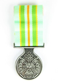
Medal - Military Kid Medallion, Foxhole Medals, After 2004
This medal was presented to the children of Victorian Wing - Warrant Officer and Non Commissioned Officers Academy Soldier who have served on operational deployments. As these young children endured an operational deployment of a parent who spent many months away from home in a foreign country representing the Australian Army. Following operations include Bougainville, East Timor, Indian Ocean, Solomon Islands, Meddle East Area, Afghanistan and Sinai.Presented by the Government to children whose parents had served overseas Silver medal with pale green, yellow, orange and deeper green ribbon. It has a metal type container with a clear plastic front and also a black carry bag with Military Kid and print of medal on front. The design is based on the Australian Tri Service Logo. More detailed information can be found on Military Kids websiteOn reverse: "For perseverance on the home front during your parents deployment"; map of Australia (haut relief)military kid, military medal, kids medal -
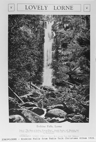 Lorne Historical Society
Pamphlet - Tourist Brochure, Lovely Lorne
The Victorian Railways promoted tourist destinations around Victoria. A folded paper tourist brochure about Lorne The front cover is a coloured painting of Lorne from above the Erskine River towards the main beach. , on the back is a black and white sketch tourist map of the roads, tracks and beauty spots. Inside the first fold are 6 black and white photographs, Cumberland River, Mt St George, Phantom Falls, Cumberland Cliffs, Teddy’s Lookout, leafy walk towards the pier. Inside contains written descriptions of the highlights of Lorne and six black and white photographs, four general views of Lorne, Lover’s Walk, Erskine Falls . souvenirs, victorian railways, publicity -
Lorne Historical Society
Pamphlet - Tourist pamphlet Lorne, Lorne Victoria Australia
Victorian Railways printed a series of brochures publicizing holiday destinations.A folded paper souvenir pamphlet. The cover is a colored picture of Lorne from Scotsman’s Hill with two bathing suited young women in the foreground, and a blurb extolling the virtues of Lorne. On the back is a red, yellow and blue map of Lorne and district. Inside are eight black and white photographs of Lorne attractions,; the Main Street, tennis courts, Erskine River, walking tracks and the George River with the phrase ,” The resort that embraces everything for the perfect holiday.”souvenirs, pamphlets, victorian railways, -
 Greensborough Historical Society
Document - Document Collection, Local Council Representation Review, 2019_
Contents: 2 x Newspaper Clippings: Banyule City Council Electoral Representative Review, Heidelberg Leader 20/08/2019 and Diamond Valley Leader 21/08/2019. Local Council Representative Review Submission Guide. Victorian Electoral Commission, 2019. 24 p., text. General information for those making a submission to a review. Local Council Representative Review Preliminary Report: Banyule City Council. Victorian Electoral Commission, August 2019. 31 p., text and colour maps. Reports on submissions and gives 3 options for electoral review in Banyule. Local Council Representative Review: Banyule City Council 1. Public hearing agenda and attachments. 25/09/2019. 9 p. 2. Public hearing agenda and attachments. 25/09/2019. 2 p. Agenda and handwritten notes by R. Bray. Local Council Representative Review Final Report: Banyule City Council. Victorian Electoral Commission, October 2019. 46 p., text and colour map. Recommends increasing the number of councillors and wards to 9. 2 newspaper clippings, 3 booklets and agenda with attachments. Filed in black plastic folder.banyule city council, victorian electoral commission, local council representative review 2019 -
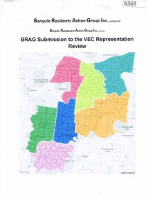 Greensborough Historical Society
Document, BRAG submission to the VEC Representation Review, by Banyule Residents Action Group Inc, 2019_
This is a submission to the Victorian Electoral Commission, which periodically reviews electoral representation in municipal areas. The last review of Banyule City Council was in 2007.7 p. typescript with colour mapbanyule city council, brag banyule residents action group -
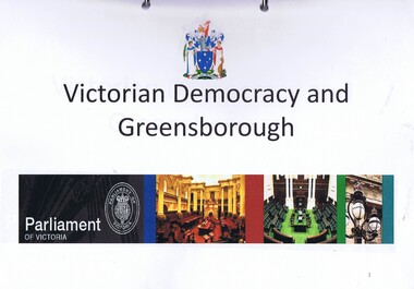 Greensborough Historical Society
Folder, Victorian democracy and Greensborough, compiled by Anne Paul, 2019_06
Outline of events leading to independent separate representative government for Victoria in 1850, and information on electoral districts and parliamentary members in the Greensborough and surrounding areas to date. Talk presented by Anne Paul to a GHS General meeting on 29 June 2019.90 p. in loose leaf ring binder. Text, maps and colour illustrations. Printed copy of PowerPoint presentationgreensborough, victoria parliament, anne paul -
 Greensborough Historical Society
Folder, Ian Bennetts, Is there a pattern to the distribution of burglaries and thefts reported to the Greensborough police station, and what factors may influence this? by Ian Bennetts, 1990_
Year 12 Geography individual research project, Montmorency Secondary College, 1990. Investigates whether there a pattern to the distribution of burglaries and thefts reported to the Greensborough police station, and what factors may influence this? by Ian Bennetts72 p. spiral bound loose leaf folder. Typescript, coloured maps and diagramsVictorian Police logo on title page.thefts, greensborough, police - greensborough -
 Greensborough Historical Society
Journal - Article, Journal, Victorian Historical Journal, Batman's route revisited: his exact steps to a new treaty site, 2014_06
Article from the Victorian Historical Journal Vol.85, No.1, June 2014. Discusses John Batman's 1835 visit to Port Phillip and possible alternative sites for signing his treaty with Indigenous people of the area.21 pages, maps.john batman, batmans treaty -
 Greensborough Historical Society
Map, Victoria. Department of Crown Lands and Survey, Keelbundoora; Counties of Bourke and Evelyn, 1950c
... Map of the Victorian counties of Bourke and Evelyn showing... Plenty Lower Plenty melbourne Map of the Victorian counties ...Map of the Victorian counties of Bourke and Evelyn showing parish boundaries and land ownership.Show the original landholders for this area.Map on light brown parchment, covered in plastic."L.5305" and "3462" -
 Greensborough Historical Society
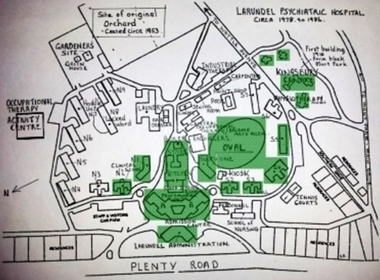
Photograph - Digital Image, Marilyn Smith, Larundel map and sign, 05/09/2017
This photograph shows the signs at the old Larundel site. Some buildings on this site are heritage listed on the Victorian Heritage Database.Digital copy of colour photographlarundel hospital -
Glenelg Shire Council Cultural Collection
Programme - Program - Victorian Decentralisation League, MODERN PRINT WARRNAMBOOL, n.d
... photographs and maps Programme Program - Victorian Decentralisation ...This league advocated for the creation of a new state encompassing Portland, Warrnambool, Camperdown and Mount Gambier.Program for the Annual Conference of the Victorian Decentralisation League at Portland September 14th and 15th 1948. Eight pages, black and white including photographs and mapsdecentralisation, programme, programme, annual conference, 1948, 1940s, post war -
Glenelg Shire Council Cultural Collection
Booklet - Booklet - South Western Victoria, n.d
Forty-two page tourist brochure of South Western Victoria, produced by Victorian Railways. Contains black and white photos of cities and towns in the south west with a short description of each. Centre page full colour map of area. Blue cover, red print, image of man in bathers on a beach.Front: 'B.W. Vivian', ink, faded -
Glenelg Shire Council Cultural Collection
Flyer - Flyer - Portland, Victoria, Oct-38
Single page flyer, folded 4 times. Tourist information for Portland, issued by Publicity and Tourist Services, Victorian Railways. Contains several black and white photos of Portland, front cover red print, blue stylised bird and sea. Back cover has tourist map of Portland and District -
Glenelg Shire Council Cultural Collection
Booklet - Brochure - Promoting Portland, Victoria, Victorian Railways Print, Oct-38
Brochure promoting Portland, folds out to A3 printed on light card. Front cover, white and blue stylised sky with sea and a seabird. 'PORTLAND, VICTORIA, AUSTRALIA' -printed in red. Back cover, black line map with roads marked in orange. Black and white photos of harbour, Dutton Beach, Gardens cottage, Henty Beach, 'Burswood', Henty Memorial, plus printed information about Portland and district.portland -
Glenelg Shire Council Cultural Collection
Headwear - Town Crier's Hat - Syd Cuffe, n.d
... - gold map of Victoria Australia, Victorian flag, silver buffalo... - gold map of Victoria Australia, Victorian flag, silver buffalo ...Syd Cuffe's Town Crier's hat. Black felt sides, turned up with point in brim at front, back of brim also turned, trimmed in gold fabric black ribbon rosette on front brim, also 4 badges - gold map of Victoria Australia, Victorian flag, silver buffalo (Manitoba) and Canadian flag. Cockatoo feather threaded through gold ribbon on back. two small fabric appliqués on back turned up brim - red maple leafFront: Maker's tag inner crown. Red flower with green stemsyd cuffe, town crier, hat, headwear -
Glenelg Shire Council Cultural Collection
Booklet, Portland Victoria: Australia's Gateway of Opportunity, Feb-65
Twenty-eight page promotional booklet, encouraging industry to invest in Portland, published by Victorian Government, 1965. Glossy card covers, black and white photos of Portland on front cover, green edging, white print, map of Portland and hinterland on back coverportland industry, advertisement, trade, economy -
Glenelg Shire Council Cultural Collection
Souvenir - Souvenir - Map and Sticker, South West Victoria, n.d
a. Tourist Guide to the S.W. region - fold out map, with tourist destinations marked; description on reverse. b. Bumper sticker, round, red, with white print ' 'Victoria, all it needs is you' - Victorian Ministry of Tourism logo. -
Glenelg Shire Council Cultural Collection
Pamphlet, The Holiday Spectacular, c. 1970
Pamphlet. South west Victoria Australia. The Holiday Spectacular produced by Victorian Government to promote tourist attractions. Multi-fold pamphlet, coloured photos, maps, tourist information. -
Glenelg Shire Council Cultural Collection
Souvenir - Commemorative Sandwich Plate - The MacRobertson Trophy Air Race, c. 1934
From Wikipedia: The MacRobertson Trophy Air Race (also known as the London to Melbourne Air Race) took place in October 1934 as part of the Melbourne Centenary celebrations. The race was devised by the Lord Mayor of Melbourne, Sir Harold Gengoult Smith,[1] and the prize money of £15,000 was provided by Sir Macpherson Robertson, a wealthy Australian confectionery manufacturer, on the conditions that the race be named after his MacRobertson confectionery company, and that it was organised to be as safe as possible.[2] A further condition was that a gold medal be awarded to each pilot who completed the course within 16 daysClear glass sandwich plate, commemorating the Air Race from UK to Australia. Map of UK and Australia, aeroplanes, etched into glass.Front: VICTORIAN AND MELBOURNE CENTENARY 1934-1935 - etched from beneathuk australia air race, macrobertson air race, 1934, melbourne centenary -
 Kiewa Valley Historical Society
Photograph Farm Land, Mount Beauty Acreage before Golf Course, Circa 1950
This photograph is a "snap shot" in time circa 1950s detailing the rural environment before the effects of the Kiewa Valley Hydro Scheme altered the basic rural setting of the valley. The golfing fairway was being mapped out on previous grazing land, before the laying of a golf course, for use by the construction workers and auxiliary administration employees of the Victorian State Electricity Commission. This photograph details a dramatic period in time which saw an enormous change to the exclusively rural area of the Kiewa Valley region in the mid 1900s. This change presented both physical and mental challenges to the existing quiet rural inhabitants of the valley. The State of Victoria had to make adjustments to the changing demands imposed by population and industrial expansions. The development of cleaner energy supplies to a growing population has its downside ,which ever way the intrusion into the "natural" landscape is made.Black and white photograph detailing surveyor posts for construction of golf course. Land used, before establishment of the Mount Beauty Village, as farming/grazing cattle and viewed towards Mount Bogong and its Alpine ranges. The photo is on 200gms paper and not on photographic paper.nilmount beauty in the 1940s - 1950s, grazing in the kiewa valley, sec victoria