Showing 1377 items matching "walking"
-
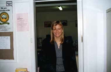 Park Orchards Community House
Photograph, Lady walking into Park Orchards Community Centre office, Unknown year
-
 National Vietnam Veterans Museum (NVVM)
Photograph, Gibbons, Denis, Walking to work
Denis Gibbons (1937 – 2011) Trained with the Australian Army, before travelling to Vietnam in January 1966, Denis stayed with the 1st Australian Task Force in Nui Dat working as a photographer. For almost five years Gibbons toured with nine Australian infantry battalions, posting compelling war images from within many combat zones before being flown out in late November 1970 after sustaining injuries. The images held within the National Vietnam Veterans Museum make up the Gibbons Collection. A colour photograph of Hue, South Vietnam, Circa 12/1968. Two local Vietnamese girls walk off to their place of work after parking their bikes in the downtown business district of Hue. One girl is wearing a traditional 'ai doa' , while the other wears modern stretch pants and sweater.photograph, hue, ao dai, vietnamese people, gibbons collection catalogue, denis gibbons, photographer, vietnam war -
 Federation University Historical Collection
Booklet - Walking Guide, Ballarat Heritage Walking Guide, c2015
35 page booklet with a detail from the Mining Exchange on the front. ballarat, walking trail, statues, gold monument, sturt street, unicorn hotel, ballarat town hall, sugg light, ballarat post office, camp street, summerscales building, state offices, police court, huyghue house, pratt's building, ymca, ballarat trades hall, ana hall, maps, lydiard street, ballarat gaol, ballarat school of mines, wesleyan church, ansonia, lynn's chambers, craig's royal hotel, her majesty's theatre, union bank building, bank of australasia, national bank, colonial bank of australasia, bank of new south wales, george hotel, old colonists' hall, art gallery of ballarat, union fidelity hall, goller's warehouse, dunn's warehouse, ludbrook house, reid's coffe police, ballarat railway station, cenotaph, queen victoria fountain, boer war memorial, burke and wills founitain, titanic memorial bandstand -
 National Vietnam Veterans Museum (NVVM)
Book, Roberts, Craig and Sasser, Charles W, The Walking Dead: A Marine's Story of Vietnam
In July 1965, Pfc. Craig Roberts crossed the Da Nang River with the 9th Marines - into the heart of a jungle alive with savage Viet Cong. Eight months later his unit would be called 'the Walking Dead'.In July 1965, Pfc. Craig Roberts crossed the Da Nang River with the 9th Marines - into the heart of a jungle alive with savage Viet Cong. Eight months later his unit would be called 'the Walking Dead'.vietnam war, 1961-1975 - personal narratives, craig roberts, da nang river, 9th marines, operation starlight -
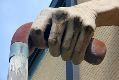 Ballarat Heritage Services
Photograph - Digital photographs, L.J. Gervasoni, Walking Stick at the former Kew Town Hall, c2011
Digital images od a hand on a wlaking stick - a detail of a sculpture attached to the front of Kew Library.sculpture, art, artwork, public art, walking stick, kew, town hall, civic centre, library, hand, cane -
Clunes Museum
Pamphlet - BROCHURE, Shire of Talbot and Clunes, Clunes Walking Tour, 1988
Folded black and white brochure with 56 points of interest, Clunes town map on reverse of brochure, image of Clunes Town Hall on front of brochure Multiple Copies50c hand written in lead pencil on front page Ramsay House 13 hand written in pencil on front page Text? Clunes Cemetery hand written in biro on front page Hand written in biro, Richard Ford built the bungalow he did not live there, he lived in Smith Street this is an error in the conservation studymap, clunes walking tour -
Lakes Entrance Historical Society
Book, Da Costa, Grant, Car Touring and Bush Walking in East Gippsland, 1988
Comprehensive guide to the magnificent forests and coastal areas of East Gippsland, Victoria, including twenty seven maps and notes on seventeen car tours, fifty nine locations of outstanding impact and 45 bushwalks. Illustrated with coloured photographicnatural history, vegetation, coast -
University of Melbourne, Burnley Campus Archives
Plan, City of Hawthorn. Proposed Walking Track - Yarra Bank, Burwood to Barkers, 1986
City of Hawthorn. Drawing No P26/9 dated November 1986.hawthorn, yarra bank, pridmore park reserve, walking tracks -
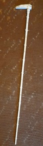 Hymettus Cottage & Garden Ballarat
Accessory - Walking cane, Ivory walking cane
ivory, cane, walking aid -
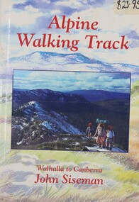 Falls Creek Historical Society
Book - Alpine Walking Track - Walhalla to Canberra, John Siseman, 1993
A guide for travellers of the Alpine Walking Track which stretches 750 kilometres through three major alpine nationals parks, ascends the highest mountains in Victoria, New South Wales and the Australian Capital Territory. It features information about alternative routes and side trips. and is illustrated, with maps and photographs.A light hearted look at the world of skiing featuring cartoons.non-fictionA guide for travellers of the Alpine Walking Track which stretches 750 kilometres through three major alpine nationals parks, ascends the highest mountains in Victoria, New South Wales and the Australian Capital Territory. It features information about alternative routes and side trips. and is illustrated, with maps and photographs.alpine walking track, bushwalking, walhalla -
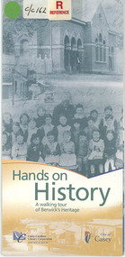 Narre Warren and District Family History Group
Pamphlet, Casey Cardinia Library Corporation, Hands on history : a walking tour of Berwick's heritage, May 2006
Hands on history : a walking tour of Berwick's heritage by Casey Cardinia Library Corporation (May 2006)non-fictionHands on history : a walking tour of Berwick's heritage by Casey Cardinia Library Corporation (May 2006)berwick (vic.), walking tour -
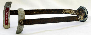 Orbost & District Historical Society
calliper, Dunlop
Walking calliper for use with a plaster of paris leg castThis item is an example of an early medical aid used at Orbost Hospital.Walking calliper - small metal frameBottom-underneath - Dunlop, Aust 1 7/8-1 7/8calliper medicine-nursing orbost-hospital -
Whitehorse Historical Society Inc.
Document, Bob Gardiner, 1964 - 1972
Biography of the race walking career of Bob Gardiner, Olympic and Commonwealth Games Walker.Biography of the race walking career of Bob Gardiner, Olympic and Commonwealth Games Walker.Biography of the race walking career of Bob Gardiner, Olympic and Commonwealth Games Walker.gardiner, bob, walking -
 Rutherglen Historical Society
Image, Barry Hill, 2/03/1997
Colour photograph of the front of the Rutherglen Common School Museum with a man walking down the driveway toward Murray StreetOn back of photo: "Taken by Barry Hill on 2-3-1997. Henry Pleming walking out."henry pleming, rutherglen common school, common school museum -
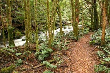
 Marysville & District Historical Society
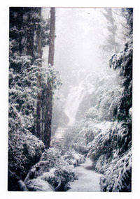
Photograph (item) - Colour photograph, 2007
A colour photograph of the walking track which leads to Steavenson Falls after a snowfall.A colour photograph of the walking track which leads to Steavenson Falls after a snowfall. The Steavenson Falls are named after the Victorian Assistant Commissioner of Roads and Bridges, John Steavenson who arrived in Victoria in the early 1860s.2007/ Steavenson Fallssteavenson falls, waterfalls, marysville, victoria, snow, john steavenson -
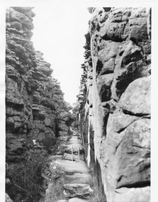 Halls Gap & Grampians Historical Society
Photograph - B/W, C 1960s
This part of the walking track is known as "Silent Street' and forms part of the Wonderland /Pinnacle track. the photo is typical of those produced by Victorian Railways for tourism.Photo shows walking track through rocky gorge. A step ladder and railings can be seen. A man is walking up the track.scenery, wonderland range -
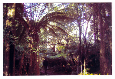 Marysville & District Historical Society
Photograph (item) - Colour photograph, 15-05-2008
A colour photograph of the walking track that leads to Keppel Falls near Marysville in Victoria.A colour photograph of the walking track that leads to Keppel Falls near Marysville in Victoria. Keppel Falls are named after the Keppel Family who were one of Marysville's earliest pioneering families.2008 05 15keppel falls, marysville, victoria, waterfalls, walking track, keppel family -
 Marysville & District Historical Society
Photograph (item) - Colour photograph, Pre 2009
A colour photograph of the walking track leading to Steavenson Falls in Marysville in Victoria.A colour photograph of the walking track leading to Steavenson Falls in Marysville in Victoria. The Steavenson Falls is named after the Victorian Assistant Commissioner of Roads and Bridges, John Steavenson who arrived in Victoria in the early 1860s.steavenson falls, waterfalls, marysville, victoria, john steavenson -
 Marysville & District Historical Society
Photograph (item) - Colour photograph, 20-09-2008
A colour photograph of the Beeches Rainforest Walking Track near Marysville in Victoria.A colour photograph of the Beeches Rainforest Walking Track near Marysville in Victoria. Starting from the spectacular Taggerty Cascades, the Beeches Rainforest Walk meanders through the ancient cool temperate rainforest of the Yarra Ranges. Dominated by Myrtle Beech trees and stands of Mountain Ash, it is home to the lyrebird which live on the forest floor.beeches rainforest walking track, marysville, victoria, taggerty river, taggerty cascades, yarra ranges, myrtle beech, mountain ash, lyrebird -
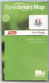 Melbourne Tram Museum
Document, Ministry of Transport, "Travel Smart Map - Port Phillip", 2010
Gives extensive details of walking cycling Public Transport in Port Phillip. Printed 2010. Yields information about Port Phillip transport and other services in 2010Map - pocket - 28 fold - showing walking, cycling and public transport in the City of Port Phillip, using a Melway Map base along with public transport information, Metcard, cycling and walking groups.tramways, melbourne, tram services, bus services, railways, port phillip, cyclists -
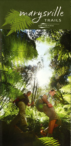 Marysville & District Historical Society
Map (Item) - Walking map, Department of Sustainability and Environment, marysville TRAILS, 07-2011
A map showing all the walking trails in and around Marysville and the district. This map was produced by the Department of Sustainability and Environment in July 2011.A map showing all the walking trails in and around Marysville and the district.ISBN 978-1-74287-122-6 (print)marysville, victoria, australia, marysville trails, department of sustainability and environment, parks victoria, steavenson falls trail, beauty spot trail, gilberts gully trail, tree fern gully trail, michaeldene trail, wilks creek trail, keppel lookout trail, lady talbot drive, taggerty cascades, the beeches, keppel falls, phantom falls, cathedral range state park, cambarville, lake mountain trails, cumberland falls, mystic mountains tourism -
 Marysville & District Historical Society
Photograph (item) - Colour photograph, Pre 2009
A colour photograph of the walking track which leads to Steavenson Falls after a snowfall.A colour photograph of the walking track which leads to Steavenson Falls after a snowfall. The Steavenson Falls are named after the Victorian Assistant Commissioner of Roads and Bridges, John Steavenson who arrived in Victoria in the early 1860s.steavenson falls, waterfalls, marysville, victoria, snow, john steavenson -
 Marysville & District Historical Society
Photograph (item) - Colour photograph, 2007
A colour photograph of the walking track which leads to Steavenson Falls after a snowfall.A colour photograph of the walking track which leads to Steavenson Falls after a snowfall. The Steavenson Falls are named after the Victorian Assistant Commissioner of Roads and Bridges, John Steavenson who arrived in Victoria in the early 1860s.March 2007 Pathway to Fallssteavenson falls, waterfalls, marysville, victoria, snow, john steavenson -
 Greensborough Historical Society
Article - Newsletter Clipping, Colin Brooks, New Local History published on Plenty River, 2023
Article about Anne Paul's book, "Walking the Kurrum Yallock" regarding the walking tracks and heritage of the Plenty River, from Brooksy's BriefingPrinted article about book written by Anne Paul regarding th walking track and heritage of the Plenty River from Brooksy's Briefingplenty river, anne paul, greensborough historical society, colin brooks -
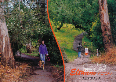 Eltham District Historical Society Inc
Postcard, Alistair Knox Park, Eltham, Victoria, Australia, 2015c
Postcard showing two views of people walking dogs through the park. Mel: 21 J6eltham, alistair-knox-park, walking, trail, postcard -
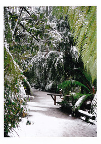
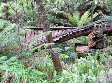
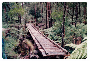 Marysville & District Historical Society
Photograph (item) - Colour photograph, Doug Orford, Unknown
A colour photograph of the timber tramway bridge along the Michaeldene Walking Track near Marysville in Victoria.A colour photograph of the timber tramway bridge along the Michaeldene Walking Track near Marysville in Victoria. The Michaeldene Trail to Taggerty River Lookout is a 4.3 kilometer lightly trafficked loop trail located near Marysville, Victoria. The track is one of several walking tracks located in and around Marysville in Victoria.Doug ORFORDtimber tramway, michaeldene walking track, marysville, victoria, walking track -
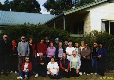 Marysville & District Historical Society
Photograph (Item) - Colour photograph, 06-04-2008
A colour photograph of the Cobaw walking group whilst on their visit to the E.S.A. Camping and Conference Centre in Marysville.A colour photograph of the Cobaw walking group whilst on their visit to the E.S.A. Camping and Conference Centre in Marysville.06-04-2008marysville, victoria, australia, e.s.a. camping and conference centre, photograph -
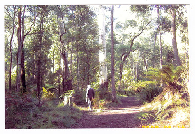 Marysville & District Historical Society
Photograph (item) - Colour photograph, 15-05-2008
A colour photograph of a man walking along the walking track that leads to Keppel Falls near Marysville in Victoria.A colour photograph of a man walking along the walking track that leads to Keppel Falls near Marysville in Victoria. Keppel Falls are named after the Keppel Family who were one of Marysville's earliest pioneering families. 2008 05 15walking track, marysville, victoria, photograph, keppel family, keppel falls, waterfalls -
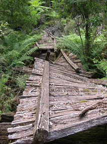 Marysville & District Historical Society
Photograph (item) - Colour photograph, 31-12-2008
A digital copy of a colour photograph of the timber tramway bridge along the Michaeldene Walking Track near Marysville in Victoria.A digital copy of a colour photograph of the timber tramway bridge along the Michaeldene Walking Track near Marysville in Victoria. The Michaeldene Trail to Taggerty River Lookout is a 4.3 kilometer lightly trafficked loop trail located near Marysville, Victoria. The track is one of several walking tracks located in and around Marysville in Victoria.timber tramway, michaeldene walking track, marysville, victoria, walking track -
 Marysville & District Historical Society
Photograph (item) - Colour photograph, 31-12-2008
A digital copy of a colour photograph of the timber tramway bridge along the Michaeldene Walking Track near Marysville in Victoria.A digital copy of a colour photograph of the timber tramway bridge along the Michaeldene Walking Track near Marysville in Victoria. The Michaeldene Trail to Taggerty River Lookout is a 4.3 kilometer lightly trafficked loop trail located near Marysville, Victoria. The track is one of several walking tracks located in and around Marysville in Victoria.timber tramway, michaeldene walking track, marysville, victoria, walking track