Showing 13880 items
matching water/irrigation
-
 Tatura Irrigation & Wartime Camps Museum
Folder, State Rivers & Water Supply Commission Construction and District Branches, 1950
Contains various publications on procedures for Water Commission constructions and irrigation methods and some photographs of assembling of a bridgeBlack and white marbled cover,metal leverwater, documents, phamphlets -
 Lakes Entrance Historical Society
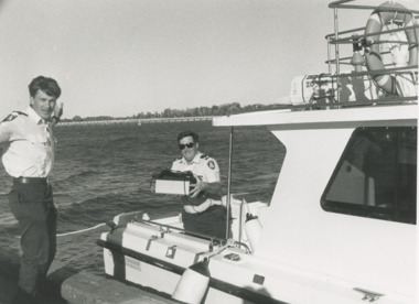
Photograph - Paynesville Water Police, Lakes Post Newspaper, 1/04/1996 12:00:00 AM
Water Police Snr Const. Tony Burke and Snr Const. Brian Hall of Paynesville Water Police docked at Lakes Entrance Victoria. An abandoned EPFRG emergency position indicating Beacon set off the alarm in Canberra initiating a full emergency response with helicopter, water police, coastguard and other units involved. The EPFRG was eventually located in a rubbish bin on a private property in Lakes EntranceBlack and white photograph of two Water Police Snr Const. Tony Burke and Snr Const. Brian Hall of Paynesville Water Police docked at Lakes Entrance Victoriacoast, defence services, police -
 Otway Districts Historical Society
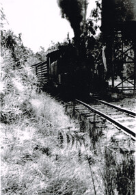
Photograph, Les Ogden, Wimba: Loco 14A takes water, c.1961, c.1961
Opened with the line as Bunding its name was changed to Wimba in November 1902 and remained as this until the line closed. The line was briefly flatish at this point until climbing more than 1000 feet to Beech Forest, so a water tank was placed on the side of a hill about 100 metres south of the station. Loco 14A takes water at this tank.B/W. Locomotive 14A, NU louvred van, and others, take water at Wimba in c.1961. Water tank top right.wimba; railway; loco 14a; -
 Surrey Hills Historical Society Collection
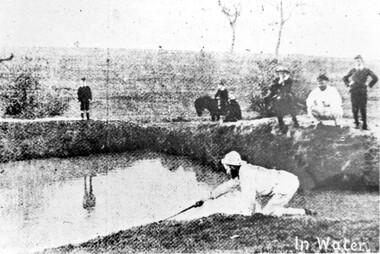
Photograph, Surrey Hills Golf Club water hazard, 1895, 1895
Reproduced by permission of Mr John Arnold from his book: "The Riversdale Golf Club - a history, 1892-1977." Copyright to book: Riversdale Golf Club. Surrey Hills Golf Club operated from 1892-1908 then moved and became Riversdale Golf Club. The game was played across paddocks from Trafalgar Street, Mont Albert to Whitehorse Road and down Victoria Crescent to where Box Hill TAFE is now located in Elgar Road. There were problems with cows eating the tee flags! The clubhouse still exists as 30 Trafalgar Street.Apart from its association in documenting the Surrey Hills Golf Club which has long disappeared, this image documents the landscape in the pre-urban era.Black and white photo of a scene at Surrey Hills Golf Club. There is a water hazard in the foreground with a lady on her knees trying to retrieve a ball from the water's edge. Three lads, one on a horse, are watching, as are 3 males to the right."In water" in the bottom right of the photo. Caption: "Captain Fred Andrew watches his partner's misfortunes during a game at Surrey Hills in 1895."sports grounds, surrey hills golf club, riversdale golf club -
 Orbost & District Historical Society
rate books, 1977 - 1984
These items were donated to Orbost & District Historical society from P.R.O.V. as a Place of Deposit (POD) item for safe keeping by a local history group or museum. The shire covered an area of 9,347 square kilometres and existed from 1892 until 1994 when it became part of the East Gippsland Shire Council. The East Gippsland Region Water Authority was constituted on January 1, 1995. The new Authority assumed responsibility for the services previously provided by the Mitchell Water Board, the Tambo Water Board, the Orbost Water Board and the Mallacoota Water Board. East Gippsland Water is the registered business name of the East Gippsland Region Water Authority. (info. from P.R.O.) These items are a historical record of Orbost Shire transactions with water management authorities which no longer exist.Seven rate books for the Shire of Orbost, Mallacoota and Cann River Water Trust. 2554.1 with records from 1977-1978 has a brown cardboard cover and string binding. 2554.2 has a brown cardboard cover with a hand-written title and green string binding. Records are from 1978 -1979. 2554.3 has a brown cardboard cover with a hand-written title and green string binding. Records are from 1919 - 1980. 2554.4 has a white cardboard cover and taped spine. In black print on the cover is 1980/1981. 2554.5 has a green cover with a metal fastening clip. Records are from 1980 -1981. 2554.6 has a white cover, taped binding and metal clips.Records are from 1982 -1983. 2554.7 has a white cover and metal rings. It is dated 1984.water-rates cann-valley-water-board -
 Greensborough Historical Society
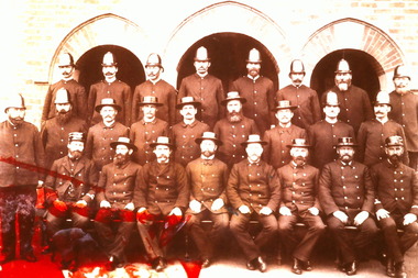
Photograph - Digital Image, Water police 1882-1890, 1882-1890
Digital copy of one of 7 slides depicting photographs of police from 1858 to 1930s. This image is of a group of water police 1882-1890.Digital copy of black and white slide.Caption on original slide 'Water police 1882-1890'victoria police, water police -
 Stawell Historical Society Inc
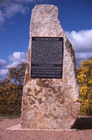
Slide, Ian McCann, Monuments Cnetenaryy of Water Supply
Momument to commemorate the Centenary of the Stawell Water Supply as designed by Mr. John D'AltonTown of Stawell Erreceted to Commemorate the the Centenary of Stawell's Water Supply System. As Designed by John D'Alton, his sceme included the diversion of Water from Fyan's Creek in the Grampians to Stawell a distance of 35 km. And involved the costruction of Timber Fluming Mountain Tunnel 300 mm Pipeline 100 years later the principle of the scheme remains the same. Work Commenced Feburary 1875 and was completed December 1881. Unveiled by The Hon. F.J. Cranter M.L.C. Minister for Water Supply On Novemebr 15th 1975 Cr. M.K. Hallam J.P. Mayordoctor's hill, hospital -
 Melton City Libraries
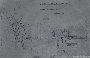
Map, Melton Water Supply, Unknown
The development that had arguably the greatest impact in encouraging population growth in the shire during this period, was the establishment of a reliable water supply for the district. This had been a major concern of the local community for over 100 years, since the Melton township was first founded. Despite various schemes over the years to create a reliable water supply, the district was still dependent on bores, wells and tanks when the Melton Waterworks Trust was established in 1961 to address Melton’s water woes. With the opening of the Djerriwarrh Dam in December 1963, the shire’s residents finally had access to a reticulated water supply.Map shows the boundary of the area where the water will be serviced in the towncouncil -
Tatura Irrigation & Wartime Camps Museum
Folder, Irrigation in the Goulburn Valley
... Irrigation in the Goulburn Valley ...Collated information from various sources including Rushworth Chronicle on irrigation from weir to basin includes minutes of meetings 1882 and 1889 Farmers Union Meeting re experimental farm 1901Black folder with black handwritten label on a white backgroundgoulburn river -
Tatura Irrigation & Wartime Camps Museum
Folder, Irrigation in the Goulburn Valley
... Irrigation in the Goulburn Valley...irrigation ...Collated information from various sources including Rushworth Chronicle. On irrigation from weir to basin. Includes minutes of meetings 1881 and 1889. Farmers Union meeting re xperimental farm, 1901.Black folder with white handwritten label.goulburn river, document, newspapers, documents, irrigation -
 Stawell Historical Society Inc
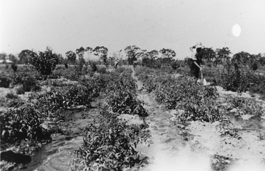
Photograph, Mr Stan Cox at the Hines Tomato Growing Property in Pomonal
Tomato Growing at Hines property Pomonal. Stan Cox in foreground digging with people in the background. The tomato's plants are being irrigated with water along the rows.Black and white photograph of a scene depicting watering a vegetable crop. Two people are working the crop in the background and in the foreground a person is digging. Stan Cox watering Hines Tomatoes Pomonal.stawell -
Stawell Historical Society Inc
Photograph, Water storage tanks part of reservoir in reefs road -- Coloured
Coloured Photo showing two water storage tanks part of reservoir in reefs roadDirt road in foreground power pole and water tanks. stawell -
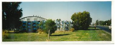 Tatura Irrigation & Wartime Camps Museum
Photograph, Goulburn Murray Water Yard
Shows picture of Goulburn Murray Water Yard, corner of Ross and William Streets, Tatura. Colour photograph showing Goulburn Murray Water Yard, corner Ross and William Streets, Tatura. Shed and water wheels. Photograph stuck onto piece of white cardboard. goulburn murray water, water wheels -
Stawell Historical Society Inc
Map, Water Supply, Wimmera Mallee Water
Water Supply, Wimmera Mallee Waterstawell, water -
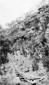
 Stawell Historical Society Inc
Photograph, Metal Water Fluming in the Grampians -- 7 Photos
Seven photos showing different views of Metal Water Fluming in the Grampians.Seven black and white photo of Fluming Water Supply Grampiansgrampians water supply flume -
 Charlton Golden Grains Museum Inc
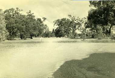
Photograph, Charlton Tribune, 1973 flood at low water bridge
1973 Flood at Charlton, Vic. At the low water bridge.Unframed photograph/ sepia of 1973 flooding of Charlton at low water bridge.flood, low water bridge -
 Phillip Island and District Historical Society Inc.
Letter, Letter to Minister for Water Supply 1936, 27 May 1936
Early attempts to have a water supply connected to Cowes. It includes figures on tourism, valuations of local properties, local primary produce and what water they require.HistoricalFoolscap size carbon copy of typed letter. 7pagesThe Honourable The Minister for Water Supply. Suggested motions to be put to the meeting of ratepayers, 13 May 1936water supply, shire of phillip island, agriculture, isle of wight, anderson property, valuations, charmadene, bonnie doon guest house, population, tourism, primary produce, d h robb, r a grayden, h v johnston, j thornborrow, e r scott -
Tatura Irrigation & Wartime Camps Museum
Book, Rodney Water Rate Book, 1937
... irrigation ...Rodney rate book for irrigation water supply, including Wyuna, Undera, Mooroopna West, Coomboona, Moora. 1937-38-39-40Large book. Red leather bound spine and corners. Faded blue cloth on front and back. Cardboard underneath, white label, black writingirrigation, books, history, local, industry -
 Melbourne Water
Photographic View Book, The Melbourne & Metropolitan Board of Works - Water Supply, Sewerage etc. ...Photographic Views, 1908
In 1891 The Melbourne and Metropolitan Board of Works (MMBW) was formed and became responsible for Melbourne's water supply. Melbourne had grown to a city of half a million people. To provide water to this rapidly growing city (especially the eastern suburbs), and to supplement the 1857 Yan Yean Reservoir, Melbourne's first water supply, the Watts River (near Healesville) was tapped. It supplied water to Melbourne, via the Maroondah aqueduct. In May 1892 the MMBW's first engineer-in-chief, Mr William Thwaites began construction on Melbourne's sewerage system. A treatment farm was built at Werribee and a pumping station was built at Spotswood (now the site of the Scienceworks Museum) to send the city's waste to Werribee. The first Melbourne homes were connected to the sewerage system in 1897. This book showcases the MMBW's infrastructure achievements and documents costs, requirements and key personnel involved in the development of the water supply and sewerage schemes.The introduction states "The water supply sources and headworks are in many cases situated in remote places and the sewerage works are chiefly underground. The Board has therefore resolved that these photographs of some of the scenes and works should be collected and bound for general information. August 1908" This book is in excellent condition and provides a detailed insight into the previous 17 years of work and the Board personnel of the MMBW leading up to 1908. It is of historical importance to the history of Melbourne for the photographic documents of places that were not generally open to the public, and for Melbourne Water in its detailed history of the MMBW in the early twentieth century. Photographic view book with hard khaki coloured cardboard cover and blue fabric binding. 120 Pages. Glossy paper with black and white plates and text about the MMBW, and scenic views and places of interest in association with the MMBW. The Melbourne & Metropolitan Board of Works - Water Supply, Sewerage etc. ...Photographic Views...mmbw, board members, sewerage, water supply, historic views, photographs -
Tatura Irrigation & Wartime Camps Museum
Book, Rodney Water Rate Book, 1940
... irrigation ...Rodney District Rate Book for irrigation water supply. Including Wyuna, Tongala, Kyabram, Toolamba, Murchison, Waranga. 1940-41-42-43Large book, red leather bound spine and corners. Blue cardboard cover covered with cloth front and back. White label, black writingirrigation, books, history, local, rural, industry -
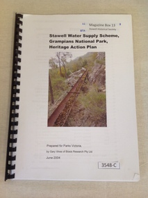 Stawell Historical Society Inc
Book, Gary Vines, Stawell Water Supply Scheme, Grampians National Park, Heritage Action Plan, 2004
White paper with black print and colour photo of a water race. this book has a black plastic bindingStawell Water Supply Scheme, Grampians National Park, Heritage Action Plan. Prepared for Parks Victoria, by Gary Vines of Biosis Research Pty Ltdstawell -
University of Melbourne, Burnley Campus Archives
Booklet, State Rivers and Water Supply Commission, Revegetating Victorian Streams, 1982
streams, revegetation -
Tatura Irrigation & Wartime Camps Museum
Booklet, Farm Chanels for Border Check Irrigation, 1991
... Farm Chanels for Border Check Irrigation...irrigation ...Explaining farm channel system. Includes information on Dethridge MeterCream cover, black writing, blue logo of Rural Water Commission of Victoria on front and channel sceneirrigation, books, history, local, rural, industry -
Clunes Museum
Document - SATURDAY MAGAZINE, CLUNES WATER HAS LONG BEEN A PROBLEM
CLUNES WATER SUPPLYBALLARAT COURIER 16/03/1974 DETAILING HISTORY OF CLUNES WATER SUPPLY FROM 1859 TO 1974water supply, history, milestones -
Whitehorse Historical Society Inc.
Article, Putting the Lid on Sources of Water, 1987
MMBW undertakes major reservoir covering and replacement program.MMBW undertakes major reservoir covering and replacement program to ensure water supply is constant and safe.MMBW undertakes major reservoir covering and replacement program.wilkes, john, mitcham reservoir, melbourne metropolitan board of works -
 Marysville & District Historical Society
Postcard (Item) - Colour tinted postcard, Murray Views, Murray Views No. 51. The Water Wheel, Marysville, Vic, 1950
A digital copy of a colour tinted postcard of the water wheel that powered the Barton's Store in Marysville in Victoria.A digital copy of a colour tinted postcard of the water wheel that powered the Barton's Store in Marysville in Victoria. This water wheel was located on the Steavenson River in Marysville. Barton's Store was established by Thomas John Barton in 1864. Thomas John Barton was born in 1836 in Gloucestershire and after his father died in 1850 arrived in Melbourne in 1852 along with his mother, adult sisters, younger brothers, his uncle, his uncle's wife Suzanna and their family. Thomas tried gold mining at Woods Point but found it too difficult. He then partnered with Ewen Hugh Cameron to provide the miners with meat. In 1864 they purchased a plot of land in Marysville and set up a butchers/abattoirs and from there began their business of taking supplies to the miners at the nearby Woods Point and Jamieson goldfields. In 1865 the business was firmly established and Thomas married Selina Croker at Heidelberg and brought her back to Marysville. Their first home was 'The Chestnuts', which included the store, and was situated on the town side next to the Steavenson River. Sadly, in 1876 Selina died of complications after giving birth to their sixth child. Thomas was in need of a nanny to care for his six children, including the newborn baby, and so he employed Emily Ada Sparke, who is the eldest daughter of the local school teacher. Thomas and Emily subsequently marry in 1878 and they go on to have a further 10 children over the next several years. Thomas assisted in the establishment of the first school in Marysville in 1870 and remained a very active member of the community including as a Councillor for the Shire of Healesville, Shire President and he was also appointed as a Justice of the Peace. Thomas died in Carlton in 1911. After their father's death, his sons Fred and Frank took over the family business, which was then known as Barton Bros Store which continued to operate until sometime in the 1970's. This postcard was produced by Murray Views in 1950 as a souvenir of Marysville.marysville, victoria, barton's store, thomas john barton, ewen hugh cameron, woods point, jamieson, gold mining, goldfields, selina croker, the chestnuts, emily ada sparke, shire of healesville, fred barton, frank barton, barton bros store, francis adam barton, frederick john barton, water wheel, steavenson river, murray views, murray views no. 51, postcard, souvenir -
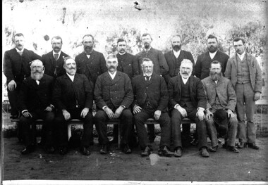 Tatura Irrigation & Wartime Camps Museum
Photograph, 1889
... irrigation ...Copy of original photograph of first commissioners of Rodney Irrigation Trust. Approx 1889Black and white photograph of first Rodney Trust Irrigation Commissioners. Names on backBack left to right - J.A, Sec. Walter Scott(Engineer), Coms. S. Lancaster, W. Bray, John Morrissy, M. Kavanaugh, C.W. Wilson, Gerald Byrne. Front Row - Coms. John McKenzie, Thomas Hogan, M. Cussen(First Chairman), M. Winter, John Stewart, R. Teese. 1st Commissioners of Rodney Irrigation Trust, 1889.rodney irrigation trust, tatura, irrigation -
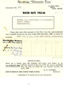 Greensborough Historical Society
Financial record - Account, Hurstbridge Waterworks Trust, Hurstbridge Waterworks Trust water rate assessment 1965-66, 13/05/1965
Hurstbridge Waterworks Trust water rates accounts for land jointly owned by W.A. (Alan) Partington and H.V. (Horrie) Burkett for 2 properties in Hurstbridge (Rose Avenue and Daphne Crescent.Alan Partington and Horrie Burkett had a history of joint property ownership from their early days in Warragul.2 Water rates accounts, black text on white paperHandwritten receipt.alan partington, william alan partington, partington family, horrie burkett, hurstbridge, hurstbridge waterworks trust -
 Stawell Historical Society Inc
Photograph, Water Supply Pipeline in the Grampians
Water Supply Pipeline Grampians with workman at bottom of the scene.Photographic print of the water supply pipeline at a scene in the Grampians. Two workmen are working along the pipeline in the photograph. stawell -
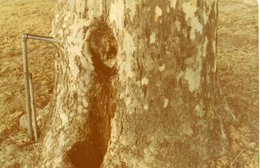 Stawell Historical Society Inc
Photograph, Central Park Tree with Water Tap, C 1960's 2012
Central Park –Tree with Water TapFour (4) Colour Photographs of a tree with a Water pipe embedded in it. One older and smaller than the other three.stawell, central park