Showing 8739 items
matching water-pipes
-
 Stawell Historical Society Inc
Photograph, Water Supply Pipeline in the Grampians
Water Supply Pipeline Grampians with workman at bottom of the scene.Photographic print of the water supply pipeline at a scene in the Grampians. Two workmen are working along the pipeline in the photograph. stawell -
 Stawell Historical Society Inc
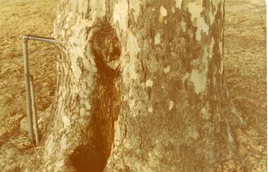
Photograph, Central Park Tree with Water Tap, C 1960's 2012
Central Park –Tree with Water TapFour (4) Colour Photographs of a tree with a Water pipe embedded in it. One older and smaller than the other three.stawell, central park -
 Tatura Irrigation & Wartime Camps Museum
Photograph, Water Tower Kerford Street Tatura
Shows picture of the original Water Tower, which was situated in Kerford Street, Tatura. Sepia photograph showing the original water tower. Photograph stuck onto piece of white cardboard. tatura victoria, water tower tatura, kerford street tatura -
 Otway Districts Historical Society
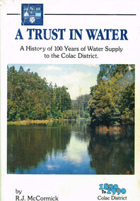
Book, A trust in water, 1990
The harnessing of the bountiful water resources of the Otways as a critical element in the urban and agricultural development of the Colac region.A trust in water. A history of 100 years of water supply to the Colac district. R.J. McCormick. 1st ed. np; R.J. McCormick; 1990. xxii, 324 p.; illus, map. Hard cover. ISBN 0 7241968 2 X a trust in water; r.j. mccormick; colac; water resources; sewerage; west gellibrand dam; otways; -
 Whitehorse Historical Society Inc.
Document, Water supply, 1927
Agreement between five orchardists for watger supply.Agreement between five orchardists to obtain and construct a private water supply to their orchards. Gordon Rennick, solicitor.Agreement between five orchardists for watger supply.toogood, charles rupert, gill, charles gilyard, pearce, edward h, lawford, thomas, lawford, victor, orchards, water supply, melbourne and metropolitan board of works, rennick, gordon, springfield road, blackburn -
Tatura Irrigation & Wartime Camps Museum
Folder, Water Conference and Deputation to the Premier 1885, 1885
Water conference and deputation to the Premier asking to assist the Goulburn Valley to construct a weirLarge black folder containing submissions to the Premier, Mr. Service, requesting funds to build water storagesvictorian water supply, book, history, local -
Clunes Museum
Document - REPORT, RURAL WATER COMMISSION OF VICTORIA, DEVELOPMENT OF PROPOSALS FOR REGIONAL MANAGEMENT - DISCUSSION PAPER SEPTEMBER 1985, 1985
FOREWORD: EARLIER THIS YEAR A PROJCT TEAM WAS ESTABLISHED TO DEVELOP PROPOSALS FOR REGIONAL MANAGEMENT OF THE COMMISSION'S ACTIVITIES....1 SPIRAL BOUND, PALE GREEN FRONT COVER OUTLINING THE DISCUSSION PAPER - REPORT BY RURAL WATER COMMISSION OF VICTORIA 1985 .2 LETTER TO MR H TOOLE FROM THE RURAL WATER COMMISSION DATED 19 SEPTEMBER 1985FOREWORD: EARLIER THIS YEAR A PROJCT TEAM WAS ESTABLISHED TO DEVELOP PROPOSALS FOR REGIONAL MANAGEMENT OF THE COMMISSION'S ACTIVITIES...local history, document, report, water supply -
 Nillumbik Historical Society Incorporated
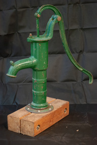
Functional object - Hand Pump, W & B Douglas Pump Factory, Hand Pump to Manually Draw Water from Well, Mid - Late 19th Century
Hand Pump. Reticulated water did not reach Diamond Creek until 1914. This beautiflly restored hand pump raised water from the outside domed well to provide cool clear water for domestic use.The Hand Pump is a well preserved example of equipment used domestically in the Diamond Creek areaHand pump used for pumping water from shallow wells. Restored by Kim Howard in 1996. Green. Column is screwed to base which is mounted on Redgum planks.PATENTED 1842, W & B DOUGLAS, "MIDD'A CONN.#handpump, #waterpump, #domesticuse -
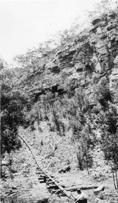
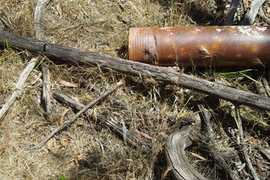
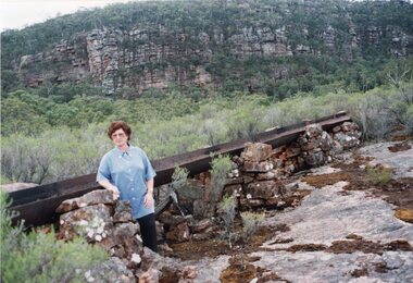 Stawell Historical Society Inc
Photograph, Fluming Water Supply in the Grampians with Stawell Historical Society Members inspecting the old Fluming -- 6 photos -- Coloured
Six coloured photos of Stawell Historical Society Members inspecting the old fluming. Some of the photos are of the remains of the open water flume in Grampians. 6 coloured photos of various views of water pipe line through different locations.grampians water supply flume -
 Greensborough Historical Society
Photograph - Digital image, Marilyn Smith et al, Janefield Precinct: Terra cotta pipes, 27/11/2014
Janefield Precinct: Terra cotta pipes. The remains of this site are between Greensborough and Janefield. A RAAF Hygiene Training Camp was located on the Plenty River, just south of the Janefield community. It was in use from 1944 to 1946. The Camp was constructed from salvaged materials. Instruction included building and maintenance of grease traps, latrines, elementary plumbing and carpentry.Early remains of a WW2 training camp Digital colour photograph.janefield -
 Tatura Irrigation & Wartime Camps Museum
Photograph, Goulburn Murray Water Tatura
Shows picture of the premises of Goulburn Murray Water, Casey Street, Tatura. Colour photograph showing the premises of Goulburn Murray Water, Casey Street, Tatura. Photograph stuck onto piece of white cardboard. tatura victoria, tatura businesses, goulburn murray water -
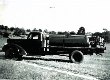 Hume City Civic Collection
Photograph, Water carrier
The Dodge water truck was used in the past by the Sunbury Country Fire members. Country Fire Authority is a volunteer fire fighting organisation attached to many rural towns throughout Victoria and in an important organisation for the state.A black and white scanned photograph with a white border of a fire fighter's water truck. It is parked in a cleared area with a line of trees in the background.water truck, dodge truck, country fire authority -
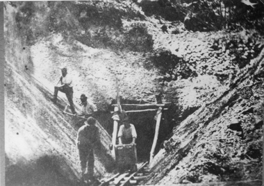 Stawell Historical Society Inc
Photograph, Water Supply Tunnel -- during Construction with 4 men working at tunnel entrance
Water Supply Tunnel. Four men working at Tunnel entrance. Grampians Range near Pomonal. Two men are working on the side of the embankment and the other 2 are working just outside the tunnel entrance. Four men working at the water supply tunnel entrance in Grampians Range near Pomonal.stawell grampians -
 Stawell Historical Society Inc
Photograph, Water Flume fo the Stawell Water Supply
B/W Photograph of Water Flume with trees either side. Mountain Range in Background. This was part of Stawell Water Supply. water supply, water -
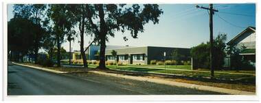 Tatura Irrigation & Wartime Camps Museum
Photograph, Goulburn Murray Water Tatura
Shows picture of the Goulburn Murray Water office, Casey Street, Tatura. This used to be the former site for Tatura Primary School.Colour photograph showing Goulburn Murray Water, Casey Street, Tatura. Photograph stuck onto piece of white cardboard. goulburn murray water tatura, casey street tatura, tatura primary school -
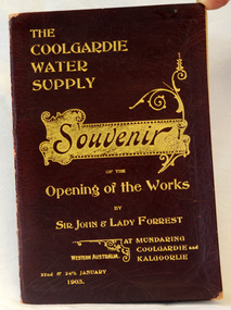 Orbost & District Historical Society
program, The Coolgardie Water Supply, 1903
This program belonged to Dr James Kerr. Conceived by Engineer-in-Chief C.Y. O’Connor and completed in 1903, the Coolgardie Goldfields Water Supply Scheme comprised a reservoir on the Helena River, eight steam-driven pumping stations and 566 kilometres of steel pipeline supplying 23,000 kilolitres of water daily to the arid goldfields of Western Australia. The project was officially opened by Sir John and Lady Forrest in January 1903. "Great pomp and ceremony heralded the arrival of water and the opening of the Scheme. Clean, fresh water could now be easily obtained in some of Australia's harshest country. However, this victory came at a great cost. The stress of the bold project was too much for O’Connor, who, after enduring endless criticism, took his life on 10 March 1902, before the Scheme was completed." - Western Australian Museum : The Coolgardie Goldfields Water Supply Scheme was an ambitious engineering feat because at the time water had never been lifted so high nor pumped so far (about 560 km). The Scheme, which pumps water from the better-watered coastal area, operates to this day. This item is associated with an historic event in the history of opening up arid areas of Australia to settlement. The item is associated with Dr James Kerr, the first doctor to settle in Orbost.A souvenir program from the opening of the works of the Coolgardie Water Supply. It has a maroon cover with gold print. Details include the date and place.coolgardie-water-supply western-australia-goldfields -
Tatura Irrigation & Wartime Camps Museum
Photograph, State Rivers and Water Supply Commission, 1957
This photograph was taken for the State Rivers and Water Supply Commission - for display purposes.Large sepia photograph dry mounted to cream board. Sign board with Engineer Ron Dickson looking at sign on left of photographState Rivers and Water Supply Commission / Goulburn Irrigation System / Enlargement and Remodelling Project / Design and Construction Depot / Enquiries at General Office.irrigation, victoria state rivers and water supply commission, ron dickson -
 Stawell Historical Society Inc
Photograph, Panorama of Stawell from Big Hill with the Stawell Water Supply Dam -- 3 Photos
Three views from Big Hill December 9th 1928 Davis Open Cut in foreground Black Range at Back. Stawell Court House with mining holes in foreground. Water Reservoir between trees. 3 Black & White photos of Stawell water supply dam taken from Big Hill.(29.11). Stawell from Big Hill Dec 9th 1928. - (29.11a) Nov 1928. L.C. Langford. - (29.11b). Stawell from Big Hill Dec 9th 1928. stawell -
Tatura Irrigation & Wartime Camps Museum
Book, Rodney Irrigation (A Diary of a Water Guard), 1891
Booik used as a diary for work as a channel and water guardMaroon and red mottled coloured book with maroon spine binding. Blue paper inside book. Handwritten in pen and inkInside back page :- Rodney Irrigation & Water Supply Trust overseer in charge of Girgarre & Girgarre East of Mt. Scobie channels. Memorandum book.rodney irrigation, diary of a water guard, irrigation, payten r, tatura, books, history, local -
 Wodonga & District Historical Society Inc
Drawing - Water Tower, Wodonga, 2020
THE WATER TOWER is a major landmark of High Street, Wodonga. It began operation from 1924 until it ceased operation in 1959. It stood unused for a decade until the lower section was modified and put to use as “ The Tower’s Cobbler’s Inn” in 1962. In 1972 Wodonga City Council proposed to demolish the Tower. Their suggestion received an unfavorable response from the city’s citizens, so the Tower still stands today.Donated by Dr. Imalka WettesingeRepresentation of the Water Tower in High Street, Wodonga in white framewodonga water tower, scenic features wodonga -
Clunes Museum
Document - ARCHITECTURAL DRAWINGS, CLUNES WATER SUPPLY
CLUNES WATER SUPPLY .1 DRAWING No 21 (CHANGED TO 11). LOWER WEIR. DETAILS OF MASONRY - DESIGN B .2 DRAWING No 5 CONTRACT No 2. LONGITUDINAL SECTION OF CENTRE LINE OF LOWER AQUEDUCT FROM WEIR A TO SERVICE RESERVOIR .3 DESIGNS FOR WEIRS - CROSS SECTION OF THE BED OF THE CREEK SHOWING WEIR STRUCTURE. .4 DRAWING No 11. LONGITUDINAL SECTION - PROPOSED LINE OF PIPES No 1 RESERVOIR. .5 DRAWING No 17 SECTIONS. HANDWRITTEN. .6 DRAWING No 5. PLAN OF LINE OF PIPES No 1 RESERVOIR..2 HANDWRITTEN NOTES ON REAR IN PENCILclunes, water supply, drawings -
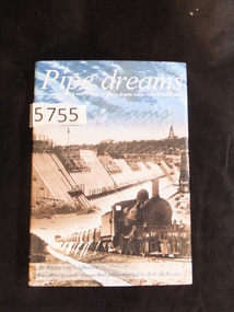 Stawell Historical Society Inc
Book, Rhona van Veldhuisen, Pipe Dreams, A stroll through the history of water supply in the Wimmera Mallee, 2001
A History of Domestic and Stock Water supply in the Wimmera Mallee from 1836 to 1997Blue Hard Cover with Gold Print. Dust Jacket. Blue sky with clouds above b/W/ dam wall under construction, steam Train in foregound Pipe dreams A stroll through the history of water supply in the Wimmera Mallee. By Rhonda van Veldhuisen based on records researched by Bob McIIvenastawell water supply -
 Whitehorse Historical Society Inc.
Photograph, Vitclay Pipes Pty Ltd, 1995
First owners, Whites of England - hand made bricks, coffee jugs, hand made agricultural pipes and garden edgings. 1911 Commonwealth Insulator Co run by Gee Brothers - stone ginger bottles, insulators for PMG. 1920 Parker & Strangwood. Closed for a short while. 1931 Descendants of Gee Brothers. 1936 Commonwealth Art Tiles, Bricks & Pottery Works. 1961 Brick and Pipe Industries. 1971 Amalgamation leading to Vitclay.Four coloured photos ( a-d ) of the dismantling of Vitclay buildings in 1995 and subsequent vacant land for housingvitclay pipes pty ltd, pipeworks, commonwealth potteries pty ltd, clay industries, gee family, commercial insulators, brick and pipe industries, commonwealth art, tile, brick and pottery works -
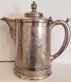 Linton and District Historical Society Inc
Trophy, Simpson Hall Miller and Co, Water Jug, Linton Fire Brigade, 1885, 1885
Won by Linton Fire Brigade in 1885. (3rd prize NFBAD Ballarat). Found on Linton tip by James Wishart in the 1960s. Mr Wishart donated the water jug to LDHS shortly before his death in 1982.Large, silver-plated water jug, with hinged lid. Flower pattern etched on front and back, with inscriptions."N.F.B.A.D-Ballarat 1885-3rd Prize-Engine practice for 8 men / Won by Linton Fire Brigade / P Wishart D Cornish S Ball J Chung". "Simpson, Hall, Miller and Co. Plate 26".linton fire brigade, p. wishart, d. cornish, s. ball, j. chung, trophies, water jugs -
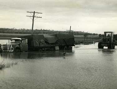 Charlton Golden Grains Museum Inc
Photograph, Cameron, Ian, Road Transport run off road in flood water 1971, 12/11/1971
Road transport run off Calder Highway in 1971 flood water. Shire grader trying to remove truck. Used in Charlton Tribune Nov 12th, 1971.B/W photo of road transport run off Highway in flood water. Shire grader trying to remove truck.flood, calder highway, charlton -
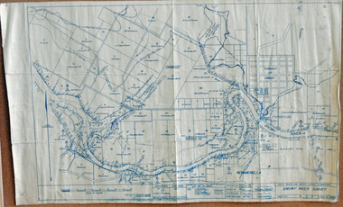 Orbost & District Historical Society
survey, 1941
this item is a useful reference tool.A survey map produced by the State Rivers and Water Supply Commission. It is on white paper with blue ink. It is a hand-drawn survey of the Snowy River in 1939-40.survey map snowy-river -
 Orbost & District Historical Society
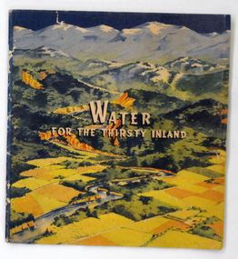
book, Water For the Thirsty Inland, 1945
Water For the Thirsty Inland was published by The Murrumbidgee Valley Water Users Association as a case for diversion of part of the Snowy River waters to the Murrumbidgee. In 1950 The Murrumbidgee Valley Water Users Association and the League established the Murray-Murrumbidgee Development Committee to ensure the Snowy Scheme was completed.This book is a significant research tool for the history of the diversion of the Snowy River.A 44 pp book, titled Water For The Thirsty Inland. On the front cover is a coloured print of a painting of a river (Snowy River?) from the mountains to the flats. The text of the title is white with a black shadow. The book contains b/w photographs and the print is black and green.Some pencilled notes on back.snowy-river murrumbidgee-valley-water-users' irrigation -
Whitehorse Historical Society Inc.
Pamphlet, Victoria's Water Resources
Pamphlet by Ministry of Water Resources and Water Supply for Use Water Wisely Campaign.Pamphlet by Ministry of Water Resources and Water Supply for Use Water Wisely Campaign.Pamphlet by Ministry of Water Resources and Water Supply for Use Water Wisely Campaign.water supply, victoria. ministry of water resources and water supply, melbourne and metropolitan board of works, state rivers and water supply commission -
Moorabbin Air Museum
Drawing (item) - C.A.C Refrigeration Circuit Details Pipes & Hoses Pipes No.1 & 2
-
 Ballarat Heritage Services
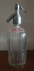
Domestic object - Soda Syphon, Schweppes Soda Water Syphon
Glass botte with metal 'Schweppes' soda syphon. "Schweppes Soda Water"soda syphon, schweppes soda water, soda water syphon