Showing 356 items matching "wood's point"
-
 Marysville & District Historical Society
Document (item) - Gold Mine Prospectus, H.D. McKie, Prospectus of the New Golden Bower & Star Gold M.Co, 1896
... wood's point... yarra track wood's point victoria mount morgan gold mining co ...A copy of the Prospectus of the New Golden Bower & Star Gold M.Co. near Marysville in Victoria.A copy of the Prospectus of the New Golden Bower & Star Gold M.Co. near Marysville in Victoria. The Golden Bower gold mine was a quartz reef mine. William Edward Chester discovered the Golden Secret gold vein which became part of the Golden Bower Mine at Chesterville near Donovans Creek on the Cumberland goldfield which he mined with George Locke until the late 1930s. new golden bower & star gold m.co., donovan's creek, nuggety gully creek, yarra track, marysville, victoria, share prospectus, upper yarra track, wood's point, victoria mount morgan gold mining co., british mount morgan mine, mr white, reefton turnoff, santa claus reef, bear's creek, mr r ely, bear's creek reef, big river, mr feely, new star reef, golden bower reef, a1 mining co, mr r m lee, locke's no.1 extended gold mining company, mr q dick -
 Marysville & District Historical Society
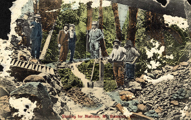
Photograph (item) - Colour tinted photograph, Sluicing for Wolfram, Mt. Bismark, 1908
... wood's point... mine wolfram tungsten marysville victoria mt bismark wood's ...An early colour tinted photograph taken at the Wilks Creek wolfram mine near Marysville in Victoria.An early colour tinted photograph taken at the Wilks Creek wolfram mine near Marysville in Victoria. The first discovery of wolfram in this location was in 1894. The first claims were lodged in 1908 and then with the start of World War I the value of tungsten increased and more claims were lodged and worked. After the war the use for tungsten diminished and the mine was abandoned until World War II when tungsten again became a valuable commodity. However due to difficulties encountered in the mining of the tungsten at the Wilks Creek mine, it was unable to pay its way and at the end of 1943 the mine closed. The viability of mining wolfram at Wilks Creek was again reviewed in the 1960s but with little success. Once again, in 1980 it was reported that there would still be wolfram to be mined but the environmental impact to an area of outstanding natural beauty was deemed to be too great to continue with the project.wilks creek, wolfram mine, wolfram, tungsten, marysville, victoria, mt bismark, wood's point -
 Marysville & District Historical Society
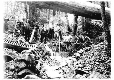
Photograph (item) - Colour tinted photograph, 1908
... wood's point... mine wolfram tungsten marysville victoria mt bismark wood's ...An early black and white photograph taken at the Wilks Creek wolfram mine near Marysville in Victoria.An early black and white photograph taken at the Wilks Creek wolfram mine near Marysville in Victoria. The first discovery of wolfram in this location was in 1894. The first claims were lodged in 1908 and then with the start of World War I the value of tungsten increased and more claims were lodged and worked. After the war the use for tungsten diminished and the mine was abandoned until World War II when tungsten again became a valuable commodity. However due to difficulties encountered in the mining of the tungsten at the Wilks Creek mine, it was unable to pay its way and at the end of 1943 the mine closed. The viability of mining wolfram at Wilks Creek was again reviewed in the 1960s but with little success. Once again, in 1980 it was reported that there would still be wolfram to be mined but the environmental impact to an area of outstanding natural beauty was deemed to be too great to continue with the project.wilks creek, wolfram mine, wolfram, tungsten, marysville, victoria, mt bismark, wood's point -
Marysville & District Historical Society
Document (item) - Report, Clement Wilks, Track to the River Jordan Gold Fields, 1864-1865
... wood's point... of the gold fields road from Healesville to the Woods Point and Jordan ...A report by Mr Road Engineer Wilks on the construction of the Yarra Track in Victoria.A report by Mr Road Engineer Wilks on the construction of the Yarra Track in Victoria. The Yarra Track is the former name of the gold fields road from Healesville to the Woods Point and Jordan Goldfields, in Victoria, Australia. By Authority: JOHN FERRES, Government Printer, Melbourneclement wilks, yarra track, marysville, victoria, wood's point, healesville, jordan gold fields -
 Marysville & District Historical Society
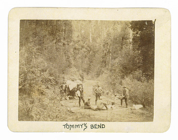
Photograph (Item) - Black and white photograph, Tommy's Bend, c1900
... marysville-wood's point road... 10 kilometres from Marysville on the Woods Point Road up ...An early black and white photograph taken at Tommy's Bend near Marysville in Victoria.An early black and white photograph taken at Tommy's Bend near Marysville in Victoria. Tommy's Bend is a stretch of road 10 kilometres from Marysville on the Woods Point Road up to Lake Mountain. This road was originally constructed as a corduroy road (or log road) is a type of road or timber trackway made by placing logs, perpendicular to the direction of the road over a low or swampy area. The result is an improvement over impassable mud or dirt roads, yet rough in the best of conditions and a hazard to horses due to shifting loose logs.ARMSTRONG COLLECTION 42 STATION STREET/ SANDRINGHAM 3191/ TEL. (03) 9521 5442/ IAN M.L. ARMSTRONG OAMtommy's bend, marysville, victoria, marysville-wood's point road, corduroy road -
 Marysville & District Historical Society
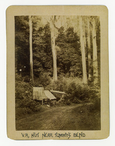
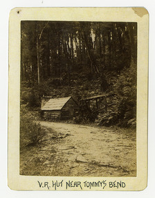
Photograph (Item) - Black and white photograph, V.R. Hut near Tommy's Bend, c1900
... marysville-wood's point road... kilometres from Marysville on the Woods Point Road up to Lake ...An early black and white photograph of a Victoria Roads worker's hut near Tommy's Bend near Marysville in Victoria. An early black and white photograph of a Victoria Roads worker's hut near Tommy's Bend near Marysville in Victoria. Tommy's Bend is a stretch of road 10 kilometres from Marysville on the Woods Point Road up to Lake Mountain.ARMSTRONG COLLECTION 42 STATION STREET/ SANDRINGHAM 3191/ TEL. (03) 9521 5442/ IAN M.L. ARMSTRONG OAMtommy's bend, marysville, victoria, marysville-wood's point road -
 Marysville & District Historical Society
Photograph (Item) - Black and white photograph, Bridge Over The Cumberland, c1900
... marysville-wood's point road... - Woods Point Road, which was historically part of the Yarra Track ...An early black and white photograph of a bridge over the Cumberland Creek near Marysville in Victoria.An early black and white photograph of a bridge over the Cumberland Creek near Marysville in Victoria. The Cumberland Creek is in the Cumberland Valley near Cambarville which was a timber town near Marysville. Cambarville is notable for its giant mountain ash (Eucalyptus regnans) trees within the Cumberland Memorial Scenic Reserve, and relics from former sawmills and gold mining. The Big Culvert is located nearby on the Marysville - Woods Point Road, which was historically part of the Yarra Track. Cambarville was established as a timber mill town in the 1940s. Timber mill owners A Cameron and FJ Barton named Cambarville. They established the mill to salvage timber from trees destroyed in the 1939 bushfires. Cambarville was impacted by the 2009 Black Saturday bushfires and any remaining structures were destroyed.ARMSTRONG COLLECTION 42 STATION STREET/ SANDRINGHAM 3191/ TEL. (03) 9521 5442/ IAN M.L. ARMSTRONG OAMcumberland creek, marysville, victoria, cumberland valley, cambarville, mountain ash, eucalyptus regnans, cumberland memorial reserve, the big culvert, marysville-wood's point road, yarra track, a cameron, fj barton, 2009 black saturday bushfires -
 Marysville & District Historical Society
Photograph (Item) - Black and white photograph, Yarra Track Hotel, c1900
... wood's point... Healesville to the Woods Point and Jordan Goldfields, in Victoria ...An early black and white photograph of a hotel along the Yarra Track.An early black and white photograph of a hotel along the Yarra Track. The Yarra Track is the former name of the gold fields road from Healesville to the Woods Point and Jordan Goldfields, in Victoria, Australia. A direct route via the Yarra River and the Great Divide was discovered by Rieck in September 1862 and became known as the Yarra Track. Early in 1863, the Victorian Government decided to construct a 193-kilometre (120 mile) road along the route. Its original width varied between 4 and 6 metres (12 and 20 feet), and was designed to accommodate horse-drawn vehicles. The Track involved the climbing of the Black Spur, descent into the Acheron Valley, and then through Marysville to the Cumberland where it followed the existing route. Unable to ascertain both the location and name of hotel.ARMSTRONG COLLECTION 42 STATION STREET/ SANDRINGHAM 3191/ TEL. (03) 9521 5442/ IAN M.L. ARMSTRONG OAMyarra track, healesville, wood's point, jordan goldfields, victoria, yarra river, great divide, reick, black spur, acheron valley, marysville, cumberland creek -
 Marysville & District Historical Society
Photograph (Item) - Black and white photograph, The "Scandinavians' - (Deserted), c1900
... wood's point... Healesville to the Woods Point and Jordan Goldfields, in Victoria ...An early black and white photograph of The Scandinavian's Hotel and Boarding House along the Yarra Track.An early black and white photograph of The Scandinavian's Hotel and Boarding House along the Yarra Track. The Yarra Track is the former name of the gold fields road from Healesville to the Woods Point and Jordan Goldfields, in Victoria, Australia. A direct route via the Yarra River and the Great Divide was discovered by Rieck in September 1862 and became known as the Yarra Track. Early in 1863, the Victorian Government decided to construct a 193-kilometre (120 mile) road along the route. Its original width varied between 4 and 6 metres (12 and 20 feet), and was designed to accommodate horse-drawn vehicles. The Track involved the climbing of the Black Spur, descent into the Acheron Valley, and then through Marysville to the Cumberland where it followed the existing route.ARMSTRONG COLLECTION 42 STATION STREET/ SANDRINGHAM 3191/ TEL. (03) 9521 5442/ IAN M.L. ARMSTRONG OAMthe scandinavians', yarra track, healesville, wood's point, jordan goldfields, victoria, yarra river, great divide, reick, black spur, acheron valley, marysville, cumberland creek -
 Marysville & District Historical Society
Photograph (Item) - Black and white photograph, Camp Opposite The "Scandinavians', c1900
... wood's point... is the former name of the gold fields road from Healesville to the Woods ...An early black and white photograph of a camp which was opposite The Scandinavian's Hotel and Boarding House along the Yarra Track.An early black and white photograph of a camp which was opposite The Scandinavian's Hotel and Boarding House along the Yarra Track. The Yarra Track is the former name of the gold fields road from Healesville to the Woods Point and Jordan Goldfields, in Victoria, Australia. A direct route via the Yarra River and the Great Divide was discovered by Rieck in September 1862 and became known as the Yarra Track. Early in 1863, the Victorian Government decided to construct a 193-kilometre (120 mile) road along the route. Its original width varied between 4 and 6 metres (12 and 20 feet), and was designed to accommodate horse-drawn vehicles. The Track involved the climbing of the Black Spur, descent into the Acheron Valley, and then through Marysville to the Cumberland where it followed the existing route.ARMSTRONG COLLECTION 42 STATION STREET/ SANDRINGHAM 3191/ TEL. (03) 9521 5442/ IAN M.L. ARMSTRONG OAMthe scandinavians', yarra track, healesville, wood's point, jordan goldfields, victoria, yarra river, great divide, reick, black spur, acheron valley, marysville, cumberland creek -
Marysville & District Historical Society
Document (Item) - Research Document, Judith Vimpani, William Cavanagh Farrell (1844-1901), 04-2020
... wood's point... review in 1863 of the routes to Wood's Point led to the Yarra ...An account of the life of William Cavanagh Farrell.An account of the life of William Cavanagh Farrell who was important to Marysville as his review in 1863 of the routes to Wood's Point led to the Yarra Track ascending the Black Spur and going on to what became the resort town of Marysville on the Steavenson River. The Yarra Track is the former name of the gold fields road from Healesville to the Woods Point and Jordan Goldfields, in Victoria, Australia. A direct route via the Yarra River and the Great Divide was discovered by Reick in September 1862 and became known as the Yarra Track. Early in 1863, the Victorian Government decided to construct a 193-kilometre (120 mile) road along the route. Its original width varied between 4 and 6 metres (12 and 20 feet), and was designed to accommodate horse-drawn vehicles. The Track involved the climbing of the Black Spur, descent into the Acheron Valley, and then through Marysville to the Cumberland where it followed the existing route.willaim cavanagh farrell, marysville, victoria, wood's point, yarra track, black spur, steavenson's creek, steavenson river, george theodore rieck -
Marysville & District Historical Society
Document (Item) - Research Document, Judith Vimpani, George Theodore Rieck (1833-pos 1884), 04-2020
... wood's point... fields road from Healesville to the Woods Point and Jordan ...An account of the life of George Theodore Rieck.An account of the life of George Theodore Rieck. The Yarra Track is the former name of the gold fields road from Healesville to the Woods Point and Jordan Goldfields, in Victoria, Australia. A direct route via the Yarra River and the Great Divide was discovered by Rieck in September 1862 and became known as the Yarra Track. Early in 1863, the Victorian Government decided to construct a 193 kilometre (120 mile) road along the route. Its original width varied between 4 and 6 metres (12 and 20 feet), and was designed to accommodate horse-drawn vehicles. The Track involved the climbing of the Black Spur, descent into the Acheron Valley, and then through Marysville to the Cumberland where it followed the existing route.george theordore rieck, marysville, victoria, james murphy, new chum creek, wood's point, gold mining, matlock, walhalla, yarra track -
Marysville & District Historical Society
Booklet (Item) - Information booklet, Artworkz Tourism, The Big Culvert, Unknown
... wood's point goldfields... road from Healesville to the Woods Point and Jordan Goldfields ...An information booklet that was produced as a guide to The Big Culvert.An information booklet that was produced as a guide to The Big Culvert. The Big Culvert is a historic granite and bluestone arch along the Yarra Track, a major route to Melbourne through the 1800s. Built in 1870 and a major piece of infrastructure for its time, the heritage listed culvert allowed water to flow under often-flooded the road. The Yarra Track is the former name of the gold fields road from Healesville to the Woods Point and Jordan Goldfields, in Victoria, Australia. A direct route via the Yarra River and the Great Divide was discovered by Rieck in September 1862 and became known as the Yarra Track. Early in 1863, the Victorian Government decided to construct a 193-kilometre (120 mile) road along the route. Its original width varied between 4 and 6 metres (12 and 20 feet), and was designed to accommodate horse-drawn vehicles. The Track involved the climbing of the Black Spur, descent into the Acheron Valley, and then through Marysville to the Cumberland where it followed the existing route.the big culvert, yarra track, victoria, healesville, wood's point goldfields, jordan goldfields, black spur, acheron valley, cumberland valley -
Marysville & District Historical Society
Flyer (Item) - Information flyer, Artworkz Tourism, The Big Culvert, 26-03-2016
... wood's point goldfields... Healesville to the Woods Point and Jordan Goldfields, in Victoria ...An information flyer that was produced as a guide to The Big Culvert.An information flyer that was produced as a guide to The Big Culvert. The Big Culvert is a historic granite and bluestone arch along the Yarra Track, a major route to Melbourne through the 1800s. Built in 1870 and a major piece of infrastructure for its time, the heritage listed culvert allowed water to flow under often-flooded the road. The Yarra Track is the former name of the gold fields road from Healesville to the Woods Point and Jordan Goldfields, in Victoria, Australia. A direct route via the Yarra River and the Great Divide was discovered by Rieck in September 1862 and became known as the Yarra Track. Early in 1863, the Victorian Government decided to construct a 193-kilometre (120 mile) road along the route. Its original width varied between 4 and 6 metres (12 and 20 feet), and was designed to accommodate horse-drawn vehicles. The Track involved the climbing of the Black Spur, descent into the Acheron Valley, and then through Marysville to the Cumberland where it followed the existing route.the big culvert, yarra track, victoria, healesville, wood's point goldfields, jordan goldfields, black spur, acheron valley, cumberland valley -
 Marysville & District Historical Society
Photograph (Item) - Black and white photograph, Unknown
... wood's point goldfields... wood's point goldfields jordan goldfields black spur acheron ...A black and white photograph taken at the unveiling of the sign placed at The Big Culvert.A black and white photograph taken at the unveiling of the sign placed at The Big Culvert. The Big Culvert is a historic granite and bluestone arch along the Yarra Track, a major route to Melbourne through the 1800s. Built in 1870 and a major piece of infrastructure for its time, the heritage listed culvert allowed water to flow under often-flooded the road. The Yarra Track is the former name of the gold fields road from Healesville to the Woods Point and Jordan Goldfields, in Victoria, Australia. A direct route via the Yarra River and the Great Divide was discovered by Rieck in September 1862 and became known as the Yarra Track. Early in 1863, the Victorian Government decided to construct a 193-kilometre (120 mile) road along the route. Its original width varied between 4 and 6 metres (12 and 20 feet), and was designed to accommodate horse-drawn vehicles. The Track involved the climbing of the Black Spur, descent into the Acheron Valley, and then through Marysville to the Cumberland where it followed the existing route.Unveiling of sign/ at "Big Culvert" In front Max Cockerrell and - Rear: second back Geoff Pope R.H.S. rear: Nancy "/ Anne "the big culvert, yarra track, victoria, healesville, wood's point goldfields, jordan goldfields, black spur, acheron valley, cumberland valley -
 Marysville & District Historical Society
Photograph (Item) - Colour photograph, 20-09-2008
... wood's point goldfields... wood's point goldfields jordan goldfields black spur acheron ...A colour photograph of the entrance to The Big Culvert.A colour photograph of the entrance to The Big Culvert. The Big Culvert is a historic granite and bluestone arch along the Yarra Track, a major route to Melbourne through the 1800s. Built in 1870 and a major piece of infrastructure for its time, the heritage listed culvert allowed water to flow under often-flooded the road. The Yarra Track is the former name of the gold fields road from Healesville to the Woods Point and Jordan Goldfields, in Victoria, Australia. A direct route via the Yarra River and the Great Divide was discovered by Rieck in September 1862 and became known as the Yarra Track. Early in 1863, the Victorian Government decided to construct a 193-kilometre (120 mile) road along the route. Its original width varied between 4 and 6 metres (12 and 20 feet), and was designed to accommodate horse-drawn vehicles. The Track involved the climbing of the Black Spur, descent into the Acheron Valley, and then through Marysville to the Cumberland where it followed the existing route.the big culvert, yarra track, victoria, healesville, wood's point goldfields, jordan goldfields, black spur, acheron valley, cumberland valley -
 Marysville & District Historical Society
Booklet - Information booklet, Ann Thomas, Wilks Creek Bridge, 1993
... wood's point goldfields... of the construction of a new road to the Woods Point and Jordan Goldfields ...A history of the Wilks Creek Bridge and its connection to the Yarra Track.Paperback. Front cover has an old photograph of the Wilks Creek Bridge.non-fictionA history of the Wilks Creek Bridge and its connection to the Yarra Track.wilks creek bridge, yarra track, narbethong, marysville, victoria, clement wilks, wood's point goldfields, jordan goldfields, john monash, monash and anderson, 2009 black saturday bushfires -
 Marysville & District Historical Society
Photograph (Item) - Colour photograph, Pre 2009
... wood's point goldfields... to the Woods Point and Jordan Goldfields. Like many bridges ...A colour photograph of the Wilks Creek Bridge near Marysville in Victoria.A colour photograph of the Wilks Creek Bridge near Marysville in Victoria. The Wilks Creek Bridge is a former timber and bluestone road bridge on the Yarra Track, and is located just off the Black Spur route, between Narbethong and Marysville, Victoria, Australia. It was built in 1870 to the design of colonial Public Works Department engineer Clement Wilks as part of the construction of a new road to the Woods Point and Jordan Goldfields. Like many bridges of the period, it had a timber superstructure employing squared beams supported by struts and straining pieces, on cut bluestone abutments. The bridge was remodelled around 1900 by engineer John Monash of the famous bridge-engineering firm of Monash and Anderson. It was last used for heavy vehicular traffic in 1980 following the realignment of Marysville Road, and was left to decay until its demolishment in 2008. All timber traces of the bridge were destroyed in the 2009 Black Saturday fires. The handcrafted bluestone masonry wingwalls and abutments, especially shaped to receive timber struts, rate among the earliest of its kind surviving intact in Victoria.wilks creek bridge, yarra track, narbethong, marysville, victoria, clement wilks, wood's point goldfields, jordan goldfields, john monash, monash and anderson, 2009 black saturday bushfires -
 Marysville & District Historical Society
Photograph (Item) - Black and white photograph, 1993
... wood's point goldfields... of the construction of a new road to the Woods Point and Jordan Goldfields ...A black and white photograph taken at the re-opening of the Wilks Creek Bridge picnic area and launch of Ann Thomas' book Wilks Creek Bridge.A black and white photograph taken at the re-opening of the Wilks Creek Bridge picnic area and launch of Ann Thomas' book Wilks Creek Bridge. The Wilks Creek Bridge is a former timber and bluestone road bridge on the Yarra Track, and is located just off the Black Spur route, between Narbethong and Marysville, Victoria, Australia. It was built in 1870 to the design of colonial Public Works Department engineer Clement Wilks as part of the construction of a new road to the Woods Point and Jordan Goldfields. Like many bridges of the period, it had a timber superstructure employing squared beams supported by struts and straining pieces, on cut bluestone abutments. The bridge was remodelled around 1900 by engineer John Monash of the famous bridge-engineering firm of Monash and Anderson. It was last used for heavy vehicular traffic in 1980 following the realignment of Marysville Road, and was left to decay until its demolishment in 2008. All timber traces of the bridge were destroyed in the 2009 Black Saturday fires. The handcrafted bluestone masonry wingwalls and abutments, especially shaped to receive timber struts, rate among the earliest of its kind surviving intact in Victoria.wilks creek bridge, yarra track, narbethong, marysville, victoria, clement wilks, wood's point goldfields, jordan goldfields, john monash, monash and anderson, 2009 black saturday bushfires -
Marysville & District Historical Society
Document (Item) - Heritage Report, Biosis Research Pty Ltd, Heritage Report-Dismantling of Wilks Creek Brdige Deck Marysville, Unknown
... wood's point goldfields... of the construction of a new road to the Woods Point and Jordan Goldfields ...A heritage report on the dismantiling of the Wilks Creek Bridge deck in Marysville in Victoria.A heritage report on the dismantiling of the Wilks Creek Bridge deck in Marysville in Victoria. The Wilks Creek Bridge is a former timber and bluestone road bridge on the Yarra Track, and is located just off the Black Spur route, between Narbethong and Marysville, Victoria, Australia. It was built in 1870 to the design of colonial Public Works Department engineer Clement Wilks as part of the construction of a new road to the Woods Point and Jordan Goldfields. Like many bridges of the period, it had a timber superstructure employing squared beams supported by struts and straining pieces, on cut bluestone abutments. The bridge was remodelled around 1900 by engineer John Monash of the famous bridge-engineering firm of Monash and Anderson. It was last used for heavy vehicular traffic in 1980 following the realignment of Marysville Road, and was left to decay until its demolishment in 2008. All timber traces of the bridge were destroyed in the 2009 Black Saturday fires. The handcrafted bluestone masonry wingwalls and abutments, especially shaped to receive timber struts, rate among the earliest of its kind surviving intact in Victoria.wilks creek bridge, yarra track, narbethong, marysville, victoria, clement wilks, wood's point goldfields, jordan goldfields, john monash, monash and anderson, 2009 black saturday bushfires -
Federation University Historical Collection
Reports, Unexplained animal kills and sighting, 1997
... wood's point... black cats tasmanian tiger marysville wood's point thylacine ...The folder or correspondence is the result of a Freedom of Informaition request made to the Department of Sustainability and Environment in 2011. The folder was collected for research being conducted by David Waldron.Folder of reports unexplained animal kills and sighting in VIctoria australian mythical animals collection, david waldron, dse, big cats, panthers pumas, nuggety, gippsland, black cats, tasmanian tiger, marysville, wood's point, thylacine, south gippsland, felid, gippsland big cat, dna, kelvin healey, peter hall, sherbrooke forest, woodside, walaces flat, mountain lion, bairnesdale, heyfield, mt taylor, walhalla, mt selma, warrnambool, tasmanian tiger, kyneton, korumburra, canadian forest, grampians, panton hill, beaconsfield, apollo bay, forrest -
Federation University Historical Collection
Reports, Big Cat sightings (dates), 1989
... wood's point... marysville wood's point thylacine south gippsland felid gippsland big ...Research of dated sightngs of Big cats in Victoria from 1868-1989. australian mythical animals collection, david waldron, dse, big cats, panthers pumas, nuggety, gippsland, black cats, tasmanian tiger, marysville, wood's point, thylacine, south gippsland, felid, gippsland big cat, kelvin healey, peter hall, sherbrooke forest, woodside, walaces flat, mountain lion, heyfield, mt taylor, walhalla, mt selma, warrnambool, kyneton, korumburra, canadian forest, grampians, panton hill, beaconsfield, apollo bay, forrest, victoria valley, rapanyup, dargo, inglewood, doncaster east, tidal river, cape bridgewater, walkerville, dooen, st arnaud, lake bung bong, mitta mitta, moliagul, emerald, kinglake, cape otway, dereel, leonard's hill, daylesford, korweinguboora, lal lal, noojee, eltham, lancefield, trentham, daisy hill, tanjil south, wonthaggi, cockatoo, warrenheip, greendale, howqua, lake buchan, melville caves, portland, mt elephant, morwell, navarre, yarram, yandoit, moonambel, maryborough, taravale, coghill's creek, trentham, carisbrook, inglewood, warrenmang, yarragon, creswick, emerald, stawel, clunes, majorca, heathcote, talbot, daylesford, newham, broadford, peter chapple -
 Federation University Historical Collection
Report, Annual Report for the Secretary For Mines, 1889, 1889
... wood's point... lamp thorneburry safety lamp wood's point clunes chiltern ...Blue soft covered book.duncan gillies, mining, safety cages, timbering in mines, ballarat minin district, statistics, chinese, fossil plants, wolf's miners' safety lamp, thorneburry safety lamp, wood's point, clunes, chiltern valley, underground survey, wire ropes, ballarat, warrenheip, dowling forest -
 Marysville & District Historical Society
Work on paper (item) - Poem, Thelma Stucliffe, To The Sir John Franklin Gold Mine From Gooleys Creek, 01-12-2004
... wood's point... goulburn river wood's point johnstons hill chinese miners black ...A poem that was written about a journey taken by a local miner's daughter to the Sir John Franklin gold mine from Gooleys Creek.A poem that was written about a journey taken by a local miner's daughter to the Sir John Franklin gold mine from Gooleys Creek.sir john franklin gold mine, gooleys creek, stander's track, goulburn river, wood's point, johnstons hill, chinese miners, black friday -
Tarnagulla History Archive
Postcard: Morning Star Mine
... Located at Wood's Point, Victoria. ... at Wood's Point, Victoria. Postcard: Morning Star Mine Stokes & Son ...David Gordon Collection. Located at Wood's Point, Victoria.