Showing 9041 items
matching yarra valley
-
 Healesville Sanctuary Heritage Centre
Newspaper - Cutting, Yarra Valley news, Record crowd at Healesville Sanctuary, 23 January 1968
... Yarra Valley news... Sanctuary Newspaper Cutting Yarra Valley news ...Attendances at Healesville Sanctuary up by more than 30,000 from last year.photocopynon-fictionAttendances at Healesville Sanctuary up by more than 30,000 from last year.1960s -
Healesville Sanctuary Heritage Centre
Newspaper - Cutting, Yarra Valley news, Lions Among The Wombats, 6 August 1968
... Yarra Valley news... Newspaper Cutting Yarra Valley news ...Healesville Lions took children from St Vincent de Paul orphanage to the Sanctuary.photocopynon-fictionHealesville Lions took children from St Vincent de Paul orphanage to the Sanctuary.1960s -
Healesville Sanctuary Heritage Centre
Newspaper - Cutting, Yarra Valley news, Healesville $40,000 Wildlife Centre, 7 January 1970
... Yarra Valley news... Healesville $40,000 Wildlife Centre Newspaper Cutting Yarra Valley ...Healesville $40,000 Wildlife Centreoriginalnon-fictionHealesville $40,000 Wildlife Centre1970s -
Healesville Sanctuary Heritage Centre
Newspaper - Cutting, Yarra Valley news, Tourist at Sanctuary, 9 June 1970
... Yarra Valley news... at Sanctuary Newspaper Cutting Yarra Valley news ...American tourist meets emu.photocopynon-fictionAmerican tourist meets emu. 1970s -
Healesville Sanctuary Heritage Centre
Newspaper - Cutting, Yarra Valley news, Falcon Stolen from Sanctuary, 23 June 1970
... Yarra Valley news... Newspaper Cutting Yarra Valley news ...Circumstances surrounding theft of a peregrine falconoriginal x 1 photocopy x 1non-fictionCircumstances surrounding theft of a peregrine falcon -
Healesville Sanctuary Heritage Centre
Newspaper - Cutting, Yarra Valley news, Theatrette for Sanctuary, 14 July 1970
... Yarra Valley news.... photocopy Theatrette for Sanctuary Newspaper Cutting Yarra Valley ...A theatrette and information centre is being built with full staffing for information and education.photocopynon-fictionA theatrette and information centre is being built with full staffing for information and education.1970s -
Healesville Sanctuary Heritage Centre
Newspaper - Cutting, Yarra Valley news, Another Lyrebird Aviary, 4 August 1970
... Yarra Valley news... Newspaper Cutting Yarra Valley news ...Second aviary for lyrebirds on the original aviary site. It will have only one bird with the plan to acquire another for matingphotocopynon-fictionSecond aviary for lyrebirds on the original aviary site. It will have only one bird with the plan to acquire another for mating 1970s -
Healesville Sanctuary Heritage Centre
Newspaper - Cutting, Yarra Valley news, New Kiosk for Sanctuary, 24 November 1970
... Yarra Valley news... for Sanctuary Newspaper Cutting Yarra Valley news ...Photo of the new kioskphotocopynon-fictionPhoto of the new kiosk1970s -
Healesville Sanctuary Heritage Centre
Newspaper - Cutting, Yarra Valley news, Governor-General visits Sanctuary, 15 June 1971
... Yarra Valley news... Sanctuary Newspaper Cutting Yarra Valley news ...Sir Paul Hasluck to open new information centre and theatre at the Sanctuary.photocopynon-fictionSir Paul Hasluck to open new information centre and theatre at the Sanctuary.1970s -
Healesville Sanctuary Heritage Centre
Newspaper - Cutting, Yarra Valley news, Lunch at Sanctuary aids The Village, 27 April 1971
... Yarra Valley news... Newspaper Cutting Yarra Valley news ...A lunch was held to raise funds for the Maroondah Retirement Village.photocopynon-fictionA lunch was held to raise funds for the Maroondah Retirement Village. 1970s -
Healesville Sanctuary Heritage Centre
Newspaper - Cutting, Yarra Valley news, Sanctuary seeks aid from Council, 4 May 1971
... Yarra Valley news... Council Newspaper Cutting Yarra Valley news ...Deputation from the Sanctuary Committee to Council regarding charging of rates on properties in the Sanctuary. Not sufficient co-operation between the Council and Sanctuary. Members of Council to visit the Sanctuary.photocopynon-fictionDeputation from the Sanctuary Committee to Council regarding charging of rates on properties in the Sanctuary. Not sufficient co-operation between the Council and Sanctuary. Members of Council to visit the Sanctuary.1970s -
 Marysville & District Historical Society
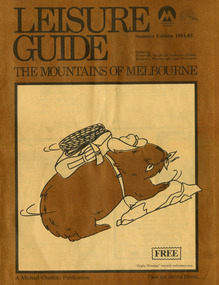
Magazine (Item) - Leisure guide, Michael Cheshire, LEISURE GUIDE THE MOUNTAINS OF MELBOURNE, 1984
... in the eastern suburbs, going through the Yarra Valley and into the Great... in the eastern suburbs, going through the Yarra Valley and into the Great... Marysville yarra-valley-and-the-dandenong-ranges A leisure guide ...A leisure guide to the mountains of Melbourne beginning in the eastern suburbs, going through the Yarra Valley and into the Great Dividing Range. This was produced by Michael Cheshire as a free publication to promote Melbourne tourism. The magazine featured Healesville, Marysville, Warburton, Eildon, Alexandra, the Upper Yarra area, and includes information on wineries in the district. It was released in the summer of 1984-1985.A leisure guide to the mountains of Melbourne beginning in the eastern suburbs, going through the Yarra Valley and into the Great Dividing Range.Summer Edition 1984-85 Featuring:/ Healesville, Marysville, Warburton, Eildon,/ Alexandra, Wineries and Upper Yarra Area.healesville, warburton, eildon, alexandra, upper yarra, marysville, victoria, australia, leisure guide, michael cheshire, blackwood holiday flats, black spur motel and caravan park, tudor lodge road house, nanda binya lodge, marysville caravan park, marysville recreation and fun park, scenic motel, the tower motel, the cumberland, cathedral restaurant, cathedral restaurant gallery, taggerty golf course, taggerty holiday units, marylyn guest house -
 Greensborough Historical Society
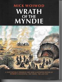
Book, Mick Woiwod, Wrath of the Myndie / Mick Woiwod, 2014_
... yarra valley... of white settlers to the Yarra Valley and their impact.... the last cry mick woiwod wurundjeri yarra valley Signed on title ..."Wrath of the Myndie" is a fictional account of the coming of white settlers to the Yarra Valley and their impact on the indigenous Wurundjeri people. 369p., illus. Paperback.Signed on title page by author "Mick Woiwod 2014"the last cry, mick woiwod, wurundjeri, yarra valley -
 Vision Australia
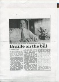
Article - Text, Braille on the bill by Claudelle Shaw
... Yarra Valley Water...Newspaper article about Neil Maxwell and the need for Yarra... Newspaper article about Neil Maxwell and the need for Yarra Valley ...Newspaper article about Neil Maxwell and the need for Yarra Valley Water to provide Braille water bills for residents who are vision impaired.1 article photocopied from a newspapernon-fictionelizabeth maxwell, neil maxwell, yarra valley water, advocacy -
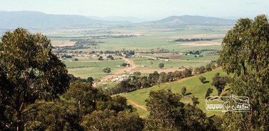
 Eltham District Historical Society Inc
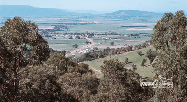
Photograph, Fred Mitchell, Yarra Glen Valley from lookout on Skyline Road, Yarra Glen, 1968, 1968
... Yarra Glen Valley from lookout on Skyline Road, Yarra Glen... Digital copy of colour photograph Yarra Glen Valley from lookout ...Digital copy of colour photographfred mitchell collection, 1968, skyline road, yarra glen -
 Eltham District Historical Society Inc
Photograph, Fred Mitchell, Yarra Glen Valley from lookout on Skyline Road, Yarra Glen, 1968, 1968
... Yarra Glen Valley from lookout on Skyline Road, Yarra Glen... Digital copy of colour photograph Yarra Glen Valley from lookout ...Digital copy of colour photographfred mitchell collection, 1968, skyline road, yarra glen -
 Kew Historical Society Inc
Photograph - Flooding of the Yarra River in North Kew, 1934
... floods -- yarra valley... in the Yarra Valley. Development beyond this point (ie Kellett Grove... in the Yarra Valley. Development beyond this point (ie Kellett Grove ...North Kew, now divided between Kew and Kew East, bordered the Yarra River. As such, it was a region subject to flooding in the Yarra Valley. Development beyond this point (ie Kellett Grove) was limited by the City of Kew's planning regulations. Prior to urban development, the area since European settlement and the first land sales in the district in the 1840s, had been used for dairy farming. Small sepia snapshot taken from the river ramp of a house at 8 Kellett Grove, in what was then known as North Kew. The point of view is from a backyard looking towards Fairfield. Beyond the fence line are two almost submerged houses. A number of people are in a motor driven boat midstream. Fairfield at this period, (ie 1934) was noted for its limited river side development. Verso: 2/12/34 / TAKEN FROM OUR RAMPyarra river -- north kew, floods -- yarra valley, floods -- north kew, floods -- 1929, floods -- 1934, natural disasters -- kew -
 Kew Historical Society Inc
Photograph - Flooding of the Yarra River in North Kew, 1934
... floods -- yarra valley... in the Yarra Valley. Development beyond this point (ie Kellett Grove... in the Yarra Valley. Development beyond this point (ie Kellett Grove ...North Kew, now divided between Kew and Kew East, bordered the Yarra River. As such, it was a region subject to flooding in the Yarra Valley. Development beyond this point (ie Kellett Grove) was limited by the City of Kew's planning regulations. Prior to urban development, the area since European settlement and the first land sales in the district in the 1840s, had been used for dairy farming. Small sepia snapshot taken from the back yard of a house at 8 Kellett Grove, in what was then known as North Kew. The point of view is from a backyard looking towards Fairfield. Floodwaters have submerged the fence and a clothes line. Verso: BACKYARD NTH. KEWyarra river -- north kew, floods -- yarra valley, floods -- north kew, floods -- 1934, natural disasters -- kew -
 Kew Historical Society Inc
Photograph - Flooding of the Yarra River in North Kew, 1934
... floods -- yarra valley... in the Yarra Valley. Development beyond this point (ie Kellett Grove... in the Yarra Valley. Development beyond this point (ie Kellett Grove ...North Kew, now divided between Kew and Kew East, bordered the Yarra River. As such, it was a region subject to flooding in the Yarra Valley. Development beyond this point (ie Kellett Grove) was limited by the City of Kew's planning regulations. Prior to urban development, the area since European settlement and the first land sales in the district in the 1840s, had been used for dairy farming. Small sepia snapshot taken from the back yard of a house at 8 Kellett Grove, in what was then known as North Kew. The point of view is from a backyard looking towards Fairfield. Verso: 8 KELLETT GROVEyarra river -- north kew, floods -- yarra valley, floods -- north kew, floods -- 1934, natural disasters -- kew -
 Kew Historical Society Inc
Photograph - Flooding of the Yarra River in North Kew, 1934
... floods -- yarra valley... in the Yarra Valley. Development beyond this point (ie Kellett Grove... in the Yarra Valley. Development beyond this point (ie Kellett Grove ...North Kew, now divided between Kew and Kew East, bordered the Yarra River. As such, it was a region subject to flooding in the Yarra Valley. Development beyond this point (ie Kellett Grove) was limited by the City of Kew's planning regulations. Prior to urban development, the area since European settlement and the first land sales in the district in the 1840s, had been used for dairy farming. Small sepia snapshot taken from the back yard of a house at 8 Kellett Grove, in what was then known as North Kew. The point of view is from a backyard looking towards Fairfield. Verso: OUR BACKYARD 8 KELLETT GROVEyarra river -- north kew, floods -- yarra valley, floods -- north kew, floods -- 1934, natural disasters -- kew -
 Kew Historical Society Inc
Photograph - Flooding of the Yarra River in North Kew, 1934
... floods -- yarra valley... in the Yarra Valley. Development beyond this point (ie Kellett Grove... in the Yarra Valley. Development beyond this point (ie Kellett Grove ...North Kew, now divided between Kew and Kew East, bordered the Yarra River. As such, it was a region subject to flooding in the Yarra Valley. Development beyond this point (ie Kellett Grove) was limited by the City of Kew's planning regulations. Prior to urban development, the area since European settlement and the first land sales in the district in the 1840s, had been used for dairy farming. Small sepia snapshot of floodwaters taken from near Kellett Grove, in what was then known as North Kew. The point of view is from a backyard looking towards Fairfield. In the foreground ar two men in a rowboat.Verso: OUR BACKYARD / Stamped 3 163yarra river -- north kew, floods -- yarra valley, floods -- north kew, floods -- 1934, natural disasters -- kew -
 Kew Historical Society Inc
Photograph - Flooding of the Yarra River in North Kew, 1934
... floods -- yarra valley... in the Yarra Valley. Development beyond this point (ie Kellett Grove... in the Yarra Valley. Development beyond this point (ie Kellett Grove ...North Kew, now divided between Kew and Kew East, bordered the Yarra River. As such, it was a region subject to flooding in the Yarra Valley. Development beyond this point (ie Kellett Grove) was limited by the City of Kew's planning regulations. Prior to urban development, the area since European settlement and the first land sales in the district in the 1840s, had been used for dairy farming. Small sepia snapshot of floodwaters taken from near Willsmere Road, in what was then known as North Kew. The point of view is looking towards Fairfield. In the foreground are two figures viewing a group in a rowboat in the middle of the flooded river. Semi-submerged street lighting indicates that entire streets had been. overwhelmed by the flood waters. Verso: WILLSMERE ROAD NORTH KEW / Stamped 3 163yarra river -- north kew, floods -- yarra valley, floods -- north kew, floods -- 1934, natural disasters -- kew, willsmere road -
 Kew Historical Society Inc
Photograph - Flooding of the Yarra River in North Kew, 1934
... floods -- yarra valley... in the Yarra Valley. Development beyond this point (ie Kellett Grove... in the Yarra Valley. Development beyond this point (ie Kellett Grove ...North Kew, now divided between Kew and Kew East, bordered the Yarra River. As such, it was a region subject to flooding in the Yarra Valley. Development beyond this point (ie Kellett Grove) was limited by the City of Kew's planning regulations. Prior to urban development, the area since European settlement and the first land sales in the district in the 1840s, had been used for dairy farming. Small sepia snapshot of floodwaters in North Kew. The point of view is of two houses belonging to local families that were surrounded by floodwater. Verso: HYATTS HOUSE / WILLSMERE ROAD / Stamped 3 163yarra river -- north kew, floods -- yarra valley, floods -- north kew, floods -- 1934, natural disasters -- kew, willsmere road -
 Kew Historical Society Inc
Photograph - Flooding of the Yarra River in North Kew, 1934
... floods -- yarra valley... in the Yarra Valley. Development beyond this point (ie Kellett Grove... in the Yarra Valley. Development beyond this point (ie Kellett Grove ...North Kew, now divided between Kew and Kew East, bordered the Yarra River. As such, it was a region subject to flooding in the Yarra Valley. Development beyond this point (ie Kellett Grove) was limited by the City of Kew's planning regulations. Prior to urban development, the area since European settlement and the first land sales in the district in the 1840s, had been used for dairy farming. Small sepia snapshot of floodwaters in North Kew, from the rear of 8 Kellett Grove. Verso: OUR BACKYARD / Stamped 52yarra river -- north kew, floods -- yarra valley, floods -- north kew, floods -- 1934, natural disasters -- kew, willsmere road -
 Kew Historical Society Inc
Photograph - Grandfather and granddaughter in the yard of 8 Kellett Grove, Kew, 1934
... floods -- yarra valley... in the Yarra Valley. Development beyond this point (ie Kellett Grove... in the Yarra Valley. Development beyond this point (ie Kellett Grove ...North Kew, now divided between Kew and Kew East, bordered the Yarra River. As such, it was a region subject to flooding in the Yarra Valley. Development beyond this point (ie Kellett Grove) was limited by the City of Kew's planning regulations. Prior to urban development, the area since European settlement and the first land sales in the district in the 1840s, had been used for dairy farming. Vivid photograph contrasting domestic life and relationships with natural disasters such as the flood of 1934.Small sepia snapshot of a grandfather and granddaughter sitting in the backyard of 8 Kellett Grove, North Kew, with the floodwaters stretching behind them.Verso: GRANDDAD AND I IN BACKYARDyarra river -- north kew, floods -- yarra valley, floods -- north kew, floods -- 1934, natural disasters -- kew, willsmere road -
 Kew Historical Society Inc
Photograph - Submerged houses in River Avenue, North Kew, 1934
... floods -- yarra valley... in the Yarra Valley. Development beyond this point (ie Kellett Grove... in the Yarra Valley. Development beyond this point (ie Kellett Grove ...North Kew, now divided between Kew and Kew East, bordered the Yarra River. As such, it was a region subject to flooding in the Yarra Valley. Development beyond this point (ie Kellett Grove) was limited by the City of Kew's planning regulations. Prior to urban development, the area since European settlement and the first land sales in the district in the 1840s, had been used for dairy farming. Vivid photograph contrasting domestic life and relationships with natural disasters such as the flood of 1934.Small sepia snapshot of two submerged houses belonging to local families in River Avenue, North Kew, during the 1934 floods. The view is presumably from near Kellett Grove looking north towards Fairfield.Verso: COES & HYATTS ROOF / RIVER AVENUE / Stamped: 6414yarra river -- north kew, floods -- yarra valley, floods -- north kew, floods -- 1934, natural disasters -- kew -
 Kew Historical Society Inc
Photograph - Flooding of the Yarra River in North Kew, 1934
... floods -- yarra valley... in the Yarra Valley. Development beyond this point (ie Kellett Grove... in the Yarra Valley. Development beyond this point (ie Kellett Grove ...North Kew, now divided between Kew and Kew East, bordered the Yarra River. As such, it was a region subject to flooding in the Yarra Valley. Development beyond this point (ie Kellett Grove) was limited by the City of Kew's planning regulations. Prior to urban development, the area since European settlement and the first land sales in the district in the 1840s, had been used for dairy farming. Vivid photograph contrasting domestic life and relationships with natural disasters such as the flood of 1934.Small sepia snapshot of the donors grandfather rescuing the family dog's kennel from rising floodwaters at the rear of 8 Kellett Grove, North Kew, .Verso: DAD SECURING NIPPY'S DOG KENNEL / Stamped 6414yarra river -- north kew, floods -- yarra valley, floods -- north kew, floods -- 1934, natural disasters -- kew -
 Kew Historical Society Inc
Photograph - Flooding of the Yarra River in North Kew, 1934
... floods -- yarra valley... in the Yarra Valley. Development beyond this point (ie Kellett Grove... in the Yarra Valley. Development beyond this point (ie Kellett Grove ...North Kew, now divided between Kew and Kew East, bordered the Yarra River. As such, it was a region subject to flooding in the Yarra Valley. Development beyond this point (ie Kellett Grove) was limited by the City of Kew's planning regulations. Prior to urban development, the area since European settlement and the first land sales in the district in the 1840s, had been used for dairy farming. .Small sepia snapshot of a local family's house in what was then River Avenue, North Kew being surrounded by floodwaters.Verso: THE SIDE OF RYANSyarra river -- north kew, floods -- yarra valley, floods -- north kew, floods -- 1934, natural disasters -- kew -
 Kew Historical Society Inc
Photograph - Flooding of the Yarra River in North Kew, 1934
... floods -- yarra valley... in the Yarra Valley. Development beyond this point (ie Kellett Grove... in the Yarra Valley. Development beyond this point (ie Kellett Grove ...North Kew, now divided between Kew and Kew East, bordered the Yarra River. As such, it was a region subject to flooding in the Yarra Valley. Development beyond this point (ie Kellett Grove) was limited by the City of Kew's planning regulations. Prior to urban development, the area since European settlement and the first land sales in the district in the 1840s, had been used for dairy farming. .Small sepia snapshot of what was then River Avenue, North Kew submerged by floodwaters.The photo was taken in the vicinity of 8 Kellett Grove, North Kew. Verso: TAKEN FROM OUR STREET JUST SEE A BIT OF RYAN'S FENCE / 1934yarra river -- north kew, floods -- yarra valley, floods -- north kew, floods -- 1934, natural disasters -- kew -
 Kew Historical Society Inc
Photograph - Flooding of the Yarra River in North Kew, 1934
... floods -- yarra valley... in the Yarra Valley. Development beyond this point (ie Kellett Grove... in the Yarra Valley. Development beyond this point (ie Kellett Grove ...North Kew, now divided between Kew and Kew East, bordered the Yarra River. As such, it was a region subject to flooding in the Yarra Valley. Development beyond this point (ie Kellett Grove) was limited by the City of Kew's planning regulations. Prior to urban development, the area since European settlement and the first land sales in the district in the 1840s, had been used for dairy farming. .Small sepia snapshot of the devastation caused by the 1934 flood.The photo was taken in the vicinity of Kellett Grove, North Kew and includes the roof of Chipperfield's Boathouse as well as other local houses.Verso: THIS IS CHIPPERFIELD'S BOAT SHEDS & COES & WILLIAMS TAKEN FROM OUR STREET / 1934yarra river -- north kew, floods -- yarra valley, floods -- north kew, floods -- 1934, natural disasters -- kew, chipperfields boathouse