Showing 1548 items matching " aerial photographs"
-
 Phillip Island and District Historical Society Inc.
Photograph, 26/12/1920
... & white photograph herald newspaper herald cup aerial derby bi ...One of a collection of over 400 photographs in an album commenced in 1960 and presented to the Phillip Island & Westernport Historical Society by the Shire of Phillip IslandPhotograph of Herald Newspaper clipping 26/12/1920, showing part of a photograph of the Bi Plane winner of "The Herald" Cup in Aerial Derby.local history, photography, herald newspaper clipping, black & white photograph, herald newspaper, herald cup, aerial derby, bi planes, john jenner, bryant west -
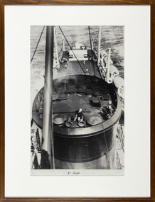 Mission to Seafarers Victoria
Photograph - Reproduction, Black and white, Mission to Seafarers Victoria, 3" Deep, c. 2009
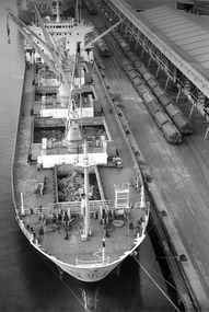
This photograph is part of reproductions of images from the MTS archive collection. Framed and mounted black and white reproduction of photograph from the archive depicting an aerial view of the funnel of a ship. A crew member is checking something on the funnel. In the background we can see 4 men playing tennis on the deck3" Deepmission to seafarers, mission to seamen, flinders street, melbourne, seafarers, seamen, padre oliver, crew, ships, seafaring life, sailors, funnel, ship, tennis, early origins, 2016, life onboard -
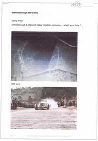 Greensborough Historical Society
Article and Photograph, Greensborough Hill Climb, 2017_
Information and photos about the Greensborough Hill Climb included a copy of the 1945 aerial survey showing the track.This photograph and text was copied from a Facebook site. Members are people who lived in the Greensborough area and share their reminiscences of the area with others. The site is administered by a GHS member but is not officially affiliated with the Society. Any information is the opinion of the contributor. Article and photograph sourced from social media.greensborough hill climb 1945, bill halliburton -
 Glenelg Shire Council Cultural Collection
Photograph - Photograph - Dutton Way, n.d
Port of Portland Authority ArchievesColoured aerial photo of Dutton Way, Showing the rock wall and groynes -
 Glenelg Shire Council Cultural Collection
Photograph - Photograph - Thomas Borthwick & Sons Abattoir, Portland, n.d
Glenelg Shire Council Records. Portland Development Committee.Aerial view of Thomas Borthwick & Sons, Abattoir, PortlandBack: Blue stamp - Portland Development Commitee. Greylead - Thos. Borthwick & Sons (Australasia) P/L.borthwicks, thomas borthwick, abattoir -
Glenelg Shire Council Cultural Collection
Photograph - Photograph - Aerial view from NE Portland Harbour, c. 1967
... Photograph - Aerial view from NE Portland Harbour... Pier still in existence. Photograph Photograph - Aerial view ...Port of Portland Authority archives.Front: 19 June 1997 Back: 19 June 1997port of portland archives -
Glenelg Shire Council Cultural Collection
Photograph - Photograph - Aerial Photograph of Portland, n.d
... Photograph - Aerial Photograph of Portland... - Aerial Photograph of Portland Unknown ...Port of Portland Authority archives.Front: (no inscriptions) Back: (no inscriptions)port of portland archives -
 Glenelg Shire Council Cultural Collection
Photograph - Photograph - Southern Farmers & Australian Estates (Portland) Pty Ltd Wool Process, n.d
Port of Portland Authority archives.Front: (no inscriptions) Back: Portland Harbor Trust Commissioners (purple stamp, top left & bottom right).port of portland archives -
 Glenelg Shire Council Cultural Collection
Photograph - Photographs - Australian Estates (Portland) Pty Ltd Wool Process & CSR Softwoods, n.d
Port of Portland Authority archives.Front: (no inscriptions) Back: (no inscriptions)port of portland archives -
 Glenelg Shire Council Cultural Collection
Photograph - Photograph - Southern Farmers & Australian Estates (Portland) Pty Ltd Wool Process, n.d
... : (no inscriptions) Back: (no inscriptions) Aerial view of factories ...Port of Portland Authority archives.Front: (no inscriptions) Back: (no inscriptions)port of portland archives -
 Glenelg Shire Council Cultural Collection
Photograph - Photograph - Aerial view of Australian Estates (Portland) Pty Ltd Wool Process, n.d
... Photograph - Aerial view of Australian Estates (Portland.... Photograph Photograph - Aerial view of Australian Estates (Portland ...Port of Portland Authority archives.Front: (no inscriptions) Back: (no inscriptions)port of portland archives -
 Glenelg Shire Council Cultural Collection
Photograph - Photograph - Unknown cargo ship, aerial view, n.d
... Photograph - Unknown cargo ship, aerial view... Photograph - Unknown cargo ship, aerial view ...Port of Portland Authority archives.Front: (no inscriptions) Back: (no inscriptions)port of portland archives -
Glenelg Shire Council Cultural Collection
Photograph - Photograph - Cape Grant Quarry, 24/01/1968
Port of Portland Authority archives.Back: 'JAN 24, 1968' - pencil top rightport of portland archives, cape grant quarry -
Glenelg Shire Council Cultural Collection
Photograph - Photograph - Cape Grant Quarry, 14/01/1958
Port of Portland Authority ArchivesBack: Purple PHT stamp '14 JAN 1958'port of portland archives, cape grant quarry -
![Photograph - Digital image, Loyola Seminary 1 [aerial view] 1934, 1934_](/media/collectors/4f729f5697f83e03086015b8/items/54b9e7f82162f10918709419/item-media/54b9e8272162f109187096d4/item-fit-380x285.jpg) Greensborough Historical Society
Greensborough Historical SocietyPhotograph - Digital image, Loyola Seminary 1 [aerial view] 1934, 1934_
... [aerial view] 1934 Photograph - Digital image ...Part of a collection of photographs of the Jesuit Seminary in Grimshaw Street Watsonia. Opened in 1934, this was a house of formation and study for the Society of Jesus. Loyola College (established 1980), now occupies the site and purchased the original building in 2002.Digital copy of black and white photograph.loyola seminary watsonia, loyola college -
![Photograph - Digital image, Loyola Seminary 7 [Aerial view with Surrounding Area] 1934, 1934_](/media/collectors/4f729f5697f83e03086015b8/items/54b9eba92162f1091870c075/item-media/54b9ebf22162f1091870c374/item-fit-380x285.jpg) Greensborough Historical Society
Greensborough Historical SocietyPhotograph - Digital image, Loyola Seminary 7 [Aerial view with Surrounding Area] 1934, 1934_
... [Aerial view with Surrounding Area] 1934 Photograph - Digital ...Part of a collection of photographs of the Jesuit Seminary in Grimshaw Street Watsonia. Opened in 1934, this was a house of formation and study for the Society of Jesus. Loyola College (established 1980), now occupies the site and purchased the original building in 2002.Digital copy of black and white photograph.loyola seminary watsonia, loyola college -
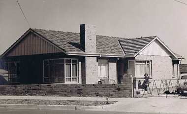 Greensborough Historical Society
Book, Typical Homes that would be constructed by Mitchell Trading Pty Ltd, 1960_
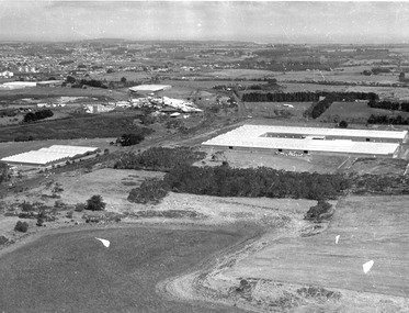
... were monasteries in the 1960s. The aerial photographs show ...An early advertising brochure for prospective homeowners to choose the style of home they would like built. House and land packages were available in the areas of Bundoora surrounding the Loyola and Parade College sites, which were monasteries in the 1960s. The aerial photographs show the open nature of the landscape from Bundoora across to Greensborough and Watsonia in the 1960s. Book of black and white photographs bound in brown card cover. Contains 14 photos of houses and shops and 14 aerial photos of Bundoora including the Loyola and Parade College areas. Includes notes from Gary Partington.In pencil inside front cover: 29/1/1960.houses, bundoora, greensborough, watsonia, loyola college, parade college, mitchell trading, aerial photography -
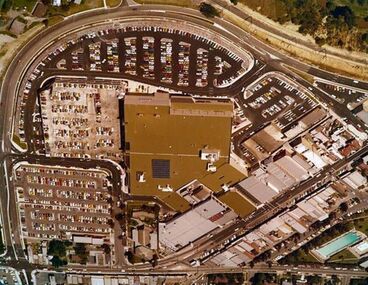 Greensborough Historical Society
Photograph - Digital image, Early Greensborough Plaza aerial view, 1979c
... Greensborough Plaza aerial view. Photograph - Digital image ...An aerial view of Greensborough Plaza around the time it opened in the late 1970s. Shows "The Circuit" and carparks.An aerial view of the 'new' Greensborough Plaza circa 1979.Links: 01993.04769 Digital copy of colour photograph.greensborough plaza, the circuit greensborough -
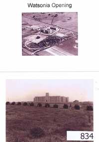 Greensborough Historical Society
Photographs, Watsonia opening; Loyola seminary. Circa 1934, 01/08/1934
... Four photographs and one photocopy. Aerial and ground views.... seminary Four photographs and one photocopy. Aerial and ground ...The Society of Jesus (Jesuits) opened the seminary in 1934. These photographs were part of the advertising for the opening ceremony. The Jesuit Order had a presence on the site from 1934 to 1974 where a house of formation and studies for the Society of Jesus was located (the current Old Loyola building purchased by the College in 2002). Loyola College Watsonia now occupies the site.1934 photographs showing the site before the residential development in the area.Four photographs and one photocopy. Aerial and ground views.loyola college, jesuits, loyola seminary -
 Greensborough Historical Society
Aerial Photograph, Flintoff land - View from above, 1945_
... Aerial Photograph...aerial photograph... family flintoff family aerial photograph "Flintoff land to west ...Section of the 1945 Greensborough aerial survey, focusing on the land belonging to the Flintoff familyPhotocopy of section of 1945 aerial survey of Greensborough area"Flintoff land to west of Diamond Creek Rd" written in pencil on backflintoff family, aerial photograph -
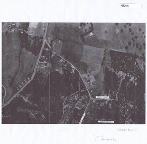 Greensborough Historical Society
Aerial Photograph, Greenhills Aerial View, 1945_
... Aerial Photograph... Aerial View Aerial Photograph ...Section from the 1945 aerial survey of Greensborough, including part of Diamond Creek Road, Greenhill Road, Crest Street and Albion Crescent.Photocopy of part of 1945 aerial survey. Some streets have been marked.greenhills -
 Greensborough Historical Society
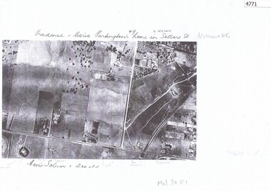
Aerial Photograph, Watsonia North 1945, 1945_
... Aerial Photograph... Plenty Lower Plenty melbourne Part of 1945 aerial survey, area ...Part of 1945 aerial survey, area of Watsonia North, including Grimshaw Street, Sellars Street and Macorna Street, indicating the home of Prudence and Maria Partington in Sellars Street.Photocopy of part 1945 aerial survey"Prudence and Maria Partington's home in Sellars St. Watsonia North"watsonia north, partington family -
 Greensborough Historical Society
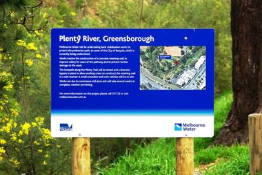
Photograph - Digital image, Marilyn Smith, Plenty River bank stabilisation 2015, 16/08/2015
River bank stabilisation project along the Plenty River at Greensborough 2015, conducted by Melbourne Water. Project sign and close-up of aerial view of site.Digital copy of colour photographplenty river, melbourne water -
Glenelg Shire Council Cultural Collection
Functional object - Folder, promotional, E.Davis & Sons Pty Ltd. Portland 3305, c. 1980
Promotional folder (folded but not fully constructed) with wrap-around aerial image of Portland (c.1980). On the front is printed, 'Welcome to Portland' Black & white, with white text.Front: Welcome to Portland growth area in the 80's Back: Photograph courtsey of Portland Harbour Trust Printed by E. Davis & Sons Pty. Ltd. Portland, 3305promotion, portland, tourism -
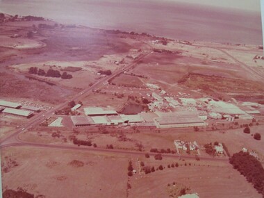
 Glenelg Shire Council Cultural Collection
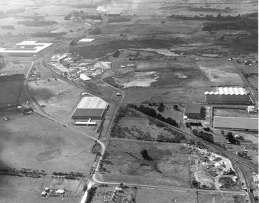
Photograph - Photograph - aerial view of Portland, 1988
... Photograph - aerial view of Portland... Photograph Photograph - aerial view of Portland Division of Survey ...Census Project No. 1995. Portland Dec. 1988.Aerial view of the "City of Portland" and surrounding rural area to a scale of 1:10,000 Aerial Photomosaic of Portland Bay, 1988Front: (no inscriptions) Back: (no inscriptions)aerial photography, central portland, portland harbour -
Glenelg Shire Council Cultural Collection
Photograph - Photograph - aerial view of Borthwicks, n.d
... Photograph - aerial view of Borthwicks... factory and fields. Photograph Photograph - aerial view ...Glenelg Shire Council RecordsAerial view of Borthwick's factory and fields.Front: (no inscriptions) Back: (no inscriptions)thomas borthwick and sons, abattoir, portland -
Glenelg Shire Council Cultural Collection
Photograph - Photograph - Tohoku Paper Co., Ltd., Akita Mill, n.d
Glenelg Shire Council RecordsAerial view of a factory on the coast. Jetties and piers in background. Framed in aluminium frame with thin plastic glazing.Front: Tohoku Paper Co., Ltd, Akita Millpaper and pulp industries, japan, maritime industry -
 Glenelg Shire Council Cultural Collection
Photograph - Photograph - Portland Foreshore, n.d
Glenelg Shire Council RecordsAerial view of Portland foreshore.Front: (no inscriptions) Back: Portland Studios/11 Julia St., Portland 3305. Tel. 232224 (black stamp centre top). Portland Development Committee Archive Material (black pen, upper centre). Portland Development Committee Inc. (blue ink stamp, centre).portland foreshore -
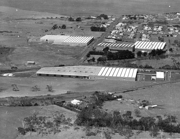
Glenelg Shire Council Cultural Collection
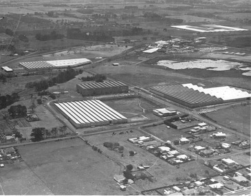
Photograph - Photograph - Portland abattoir & Portland drive-in theatre, 1970s
Donated by abattoir staff during clean-up prior to demolition in 1996. Company was then owned by Australian Meat HoldingsBlack and white photograph, framed. Frame: stained wooden moulding c. 1970s. Image: Portland abattoirs, aerial view from N.E. Portland Drive-in theatre in backgroundFront: Photocopy - legend of key functions of the abattoir buildingsaerial photography, drive-in cinema, abattoir, industry, recreation