Showing 8388 items matching " bridge"
-
 Stawell Historical Society Inc
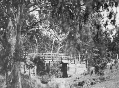
Photograph, Old wooden Bridge over Dog Trap Creek in Callawadda
Old wooden Bridge over Dog Trap Creek - Callawaddastawell -
 Stawell Historical Society Inc
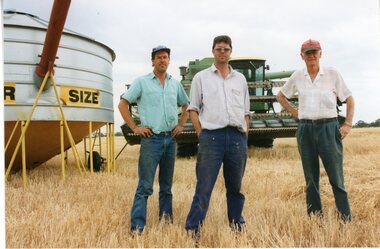
Photograph, Colin, Ian with their father Mr Ken Hyslop -- farmers from Campbells Bridge
Colin Ian and their father Ken Hyslop- C Campbells Bridgestawell -
 Malmsbury Historical Society
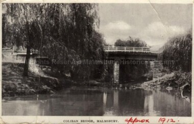
Postcard (Item), Postcard Coliban Bridge C1912 Semco Series C1912, Malmsbury c1912
Associated with - Semco Series Box 545 Buildings - Coliban Bridge -
 Stawell Historical Society Inc
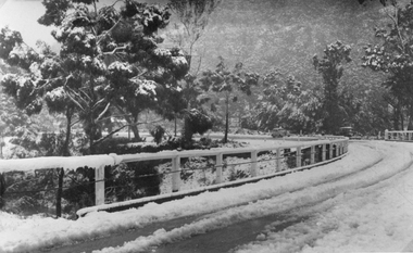
Photograph, Delley's Bridge in the Grampians with Snow 1949
Delley's Bridge Grampians Snow Scenes July 19 1949halls gap -
 Stawell Historical Society Inc
Photograph, Water well at Bridge Hotel site on the Navarre Road Concongella 2001
Water well at Bridge Hotel site Concongella taken 2001 stawell -
 Eltham District Historical Society Inc
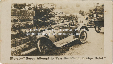
Photograph - Business Card, C. Aarons, Moral - "Never Attempt to Pass the Plenty Bridge Hotel.", c.1920
Circa 1920 Business Card: Plenty Bridge Hotel, Lower Plenty via Heidelberg C. Aarons, Licensee Humorous business card warning motorists of the dire consequences attempting to negotiate the Plenty River Bridge should they decide to pass by the hotel with stopping.marg ball collection, c. aarons, car crash, golf club hotel, lower plenty bridge hotel, plenty bridge hotel, lower plenty bridge -
 Lake Bolac & District Historical Society
Black and white photograph, Salt Creek Bridge, Lake Bolac, circa 1950
Original bridge over the Salt Creek, Lake Bolac. Situated between the present bridge and the Salt Creek outlet from the lake. Built of local redgum and yellow box from the Grampians. In the pony trap are Lloyd, Lesley and John Malin. Circa 1950.lake bolac, salt creek, bridge, redgum, yellow box, grampians, malin, 1950 -
 Melbourne Tram Museum
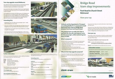
Pamphlet, VicRoads, "Bridge Road tram stop improvements", Sep. 2011
Pamphlet, printed on cream recycled paper, A3 + and A4 tear off titled "Bridge Road tram stop improvements". giving details of the Punt Road to Church St section of Bridge Road tram line. Installation of two level access tram stops to replace the existing three - Vienna style. Has details on the proposal, the background reasons, inviting people to have their say, information sessions, maps, diagrams and contact details and survey form. 2 copies held.trams, tramways, bridge rd, tram stops, vienna style stops, vicroads, disability services -
 Ballarat Tramway Museum
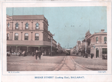
Photograph - Illustration, WTP, Bridge St (Looking East), Ballarat, c1905
Illustration of an ESCo tram leaving the intersection of Grenville St. and Bridge St. and proceeding east along Bridge St. Photo taken behind junction points. Has the Nicholl & Allan building on the left side of the photo and the Bucks Head Hotel on the right. Numerous people walking around the street. Shows overhead construction in the area. Titled Bridge St (Looking East), Ballarat. Image by WTP&Co of Ballarat. See item 841 for postcards of this image. Yields information of Bridge St at Grenville St, c1905Colour Illustration cut from a journaltramways, trams, sturt st, esco, grenville st, bridge st -
 Port Melbourne Historical & Preservation Society
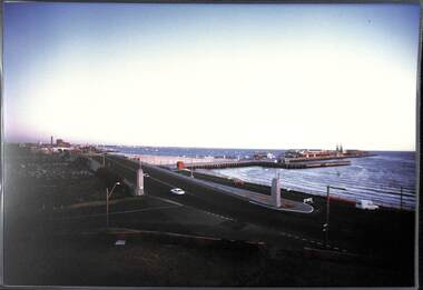
Photograph, James Lauritz, Centenary Bridge and Station Pier, 1989 - 1990
Taken from the roof of the Mission to Seamen looking across Station Pier and Centenary Bridge James Lauritz print of Port Melbourne, laminated (one of 18). Copies of slides produced for Port Melbourne Councillocal government - city of port melbourne, built environment, james lauritz, station pier, centenary bridge -
 Port Melbourne Historical & Preservation Society
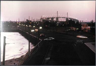
Photograph, James Lauritz, Night time view of Beach St looking West towards West Gate Bridge, 1989 - 1990
Night time view of Beach St looking West towards West Gate Bridge James LAURITZ print of Port Melbourne, laminated (one of 18). Copies of slides produced for Port Melbourne Councilbeach street, local government - city of port melbourne, built environment, james lauritz, engineering - bridges, west gate bridge -
 Melbourne Tram Museum
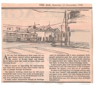
Newspaper, The Age, demolition of the cable tram winding house on the corner of Hoddle and Bridge Road, 22/12/1990 12:00:00 AM
Newspaper clipping from The Age, 22/12/1990, about the demolition of the cable tram winding house on the corner of Hoddle and Bridge Road by VicRoads, to open the areas to traffic, despite National Trust pleas.trams, tramways, cable trams, bridge road, hoddle st, winding houses, power house, demolition, national trust -
 Greensborough Historical Society
Photograph, Plenty River Bridge Greensborough, 1910c
Early photograph of Main Street bridge over the Plenty River, taken around 1910. Quirk's Tailor shop is seen in the background and a horse and cart coming down the road. The road appears unsealed. Rampant blackberries can be seen growing around the bridge abutments. Part of a collection of photographic enlargements of Greensborough sites.Black and white enlargement of photographic imagemain street bridge, main street greensborough, plenty river greensborough, quirk's tailor shop, blackberry, mckenzie bridge -
 Eltham District Historical Society Inc
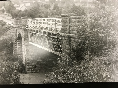
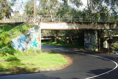
Negative - Photograph, Old Lower Plenty Bridge, 18 April 1998
Plenty River reflections through the old iron Lower Plenty Bridge; Autumn Excursion to Lower Plenty area. The blocked-off iron bridge at Lower Plenty - now re-opened and used as a footway/bike path section joining the Yarra River path.Roll of 35mm colour negative film, 2 strips and associated colour printKodak Gold 200-6activities, lower plenty bridge, autumn excursion, eltham district historical society, lower plenty -
 Melbourne Tram Museum
Document - Notice, Melbourne & Metropolitan Tramways Board (MMTB), "Reconstruction of Burnley Railway Bridge in Swan Street, Jun. 1969
Set of four notices regarding trackwork and reconstruction printed on foolscap paper. Signed by R. C. Drummond as Traffic Manager. .1 - Notice No. D1507 "Reconstruction of Burnley Railway Bridge in Swan Street - Sunday 13th April 1969" giving details of tram and bus rearrangements, procedure at the bridge for buses. .2 - Notice No. D1508 - regarding Burnley St rail bridge and the single line working that applied during the bridge reconstruction period - dated 10/4/1969. .3 - Notice No. D1546 about reconstruction of tram tracks in Collins St between Swanston and Elizabeth on Sunday 22 June 1969. Two pages, has been stapled in the top left hand corner. Gives bus and tram rearrangements. Dated 18/6/1969. .4 - Notice No. D1550 about reconstruction of tram tracks in Collins St near King St for 29 June 1969.. Two pages, has been stapled in the top left hand corner. Gives bus and tram rearrangements. Dated 24/6/1969.trams, tramways, mmtb, trackwork, burnley, swan st, signals, collins st -
 Greensborough Historical Society
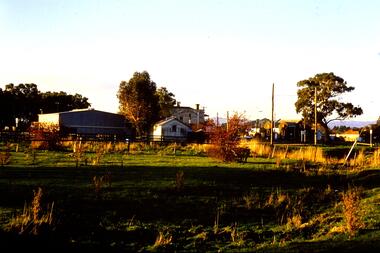
Photograph - Photograph (Copy), Anne Paul, Old bridge, Lower Plenty 2003, 2003_12
Two views of the old bridge over the Plenty River in Lower Plenty.2 colour photographs printed on paper, handwritten captionslower plenty, plenty river, floods, edward willis drive lower plenty -
 Greensborough Historical Society
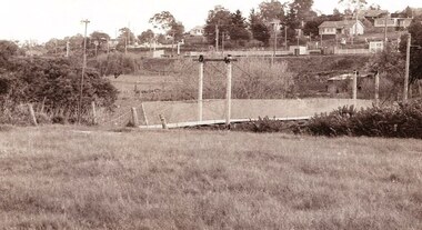
Photograph - Photograph Collection, Anne Paul, Lower Plenty Bridge and surrounds, 2002c
Six photographs of the area surrounding the Old Plenty Bridge in Lower Plenty6 colour photographs lower plenty, plenty river, old plenty bridge -
 Greensborough Historical Society
Slide - Photograph, John Ramsdale, Bridge Inn Hotel and Mechanics Institute from rear: Slide 102, 1990s
Photograph shows Bridge Inn Hotel and Mechanics Institute from rear.Part of the John Ramsdale collection of slides and audio visual material.Colour photograph scanned from slide.No maker's marks. No caption on slide.bridge inn hotel mernda, mernda mechanics institute, mernda -
 Greensborough Historical Society
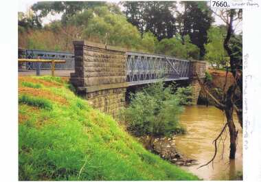
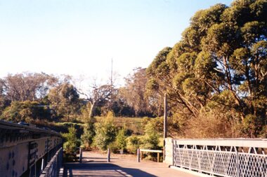
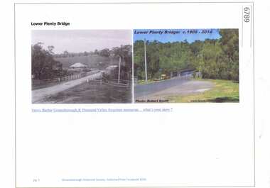
Article and Photograph, Lower Plenty Bridge, 2016_
2 Photographs of the area around the Lower Plenty Bridge, 1906 and 2014.This photograph and text was copied from a Facebook site. Members are people who lived in the Greensborough area and share their reminiscences of the area with others. The site is administered by a GHS member but is not officially affiliated with the Society. Any information is the opinion of the contributor. Article and photograph sourced from social media.lower plenty -
 Greensborough Historical Society
Photograph - Digital image, Jan Lewis, Flintoff Street swing bridge with Greensborough Railway Station in background circa 1958, 1958c
Flintoff Street swing bridge and Greensborough station in background circa 1958Digital copy of black and white photographgreensborough station, flintoff street -
 Greensborough Historical Society
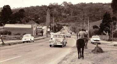
Photograph - Digital image, Jan Lewis, Horse Riding down Main Street Greensborough Station looking toward bridge circa 1958, 1958c
Main Street Greensborough Station looking toward bridge circa 1958.Digital copy of black and white photographmain street greensborough -
 Greensborough Historical Society
Photograph - Digital image, Marilyn Smith, Railway Road Rail Bridge over Plenty River Briar Hill, 17/09/2014
Rail bridge over Railway Road Greensborough, near Para Road.Digital copy of colour photographrailway road greensborough, para road greensborough -
 Eltham District Historical Society Inc
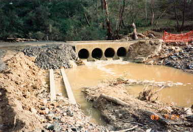
Photograph, Bridge construction over the Diamond Creek, Charlber Lane, St Andrews, 24 July 1989, 24 Jul 1989
The first BEBO Arch pre-cast concrete bridge construction in VictoriaNine colour photographic printsbebo arch, bridge construction, charlber lane, diamond creek, st andrews -
 Eltham District Historical Society Inc
Photograph, Charlber Lane Bridge, St Andrews
A BEBO Arch pre-cast concrete construction bridge, the first in VictoriaA BEBO Arch pre-cast concrete construction bridge, the first in VictoriaThree colour photographic printsbebo arch, bridge construction, charlber lane, diamond creek, st andrews -
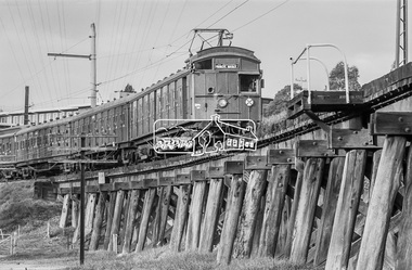 Eltham District Historical Society Inc
Photograph, George Coop, Tait Electric Train (Red Rattler) crossing the Railway Trestle Bridge at Eltham, c.1981, 1981
Heading to Princes Bridge in Melbourne Eltham Shire Council Offices in backgroundDigital TIFF file Scan of 35mm Ilford FP4 black and white transparencyeltham shire office, eltham trestle bridge, red rattler, tait train -
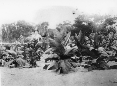 Stawell Historical Society Inc
Photograph, Mr Charles Pickering with his Tobacco Crop at Dadswells Bridge c1930
Tobacco Crop Grown by Charles Pickering at Dadswells Bridge c 1930.Black and white photograph of a scene depicting Tobacco plants. A person is standing behind the crop.stawell -
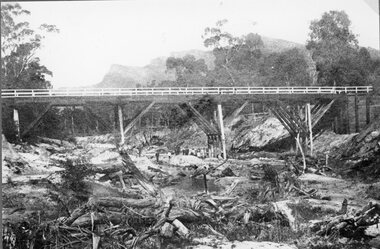 Stawell Historical Society Inc
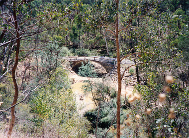
Photograph, Delley's Bridge in Hall’s Gap showing Fyans Creek riverbed 1917
Delley's Bridge Hall’s Gap 1917 showing Fyans Creek riverbedstawell -
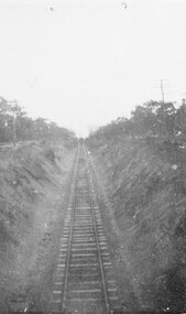 Stawell Historical Society Inc
Photograph, Railway Line from the Oddfellows Bridge c1930's
Sepia Photograph of rail line from Oddfellows Bridge 1930'sstawell railways transport -
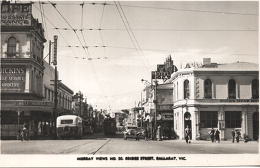 Ballarat Tramway Museum
Postcard, Murray Views, "Murray Views No. 50 Bridge Street Ballarat Vic", 1948
Photo shows the view looking east along Bridge St from Grenville St. Bogie tram 35 is in the shadows. A bus is entering Bridge St, In the view are Dickins Self service grocery, Morseheads store, CTA Hotel, and the Bucks Head Hotel. On the rear, Wal Jack to Ken Magor of Newcastle has written "No. 35 bogie to Victoria St, 1948. Bridge St from Sturt and Grenville Sts. Note two green lights on the span pole under neon sign which guards the Bridge St (bottom light) and Victoria St single track. Mt Pleasant light is on opposite side pole. No. 35 is standing at the old city terminus up to 1937."Yields information about Bridge St Ballarat and its various buildings.Postcard black and white, divided back, with a handwritten note on rear.See image 2 for details of the handwritten note by Wal Jack on the rear. tramways, trams, bridge st, tram 35, buses, dickins, bucks head hotel -
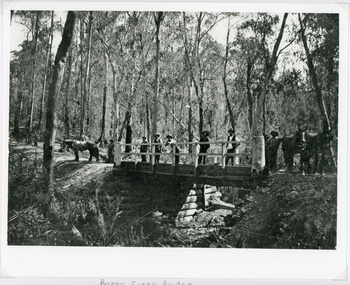 Lakes Entrance Historical Society
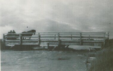
Photograph - Bridges, 1896
Original photo 12.5 x 17 cm on grey card 20 x 24.5 cmBlack and white photograph showing Boggy Creek Bridge,seven men on bridge, one horse at left end of bridge and two horses at right hand end of bridge. Bridge rests on log supports under. No water in creek. Thick bush around area. East Gippsland VictoriaBoggy Creek Bridge - Vic (Written on back)bridges, waterways, vegetation