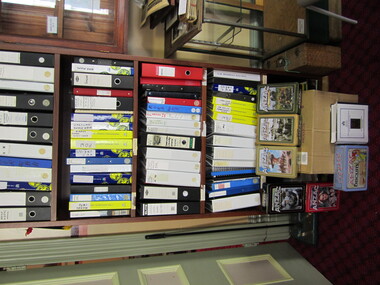
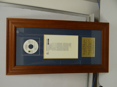
Showing 10465 items
matching plans
-
 Ballarat RSL Sub-Branch Inc.
Folder - Ballarat Avenue of Honour
Management Strategy Plan 1997literature, ballarat rsl, ballarat -
 Brimbank City Council
Brimbank Planning Scheme Frame, 1999
Brimbank Planning Scheme Frame -
 Stawell Historical Society Inc
Map, Plan Shewing Position of Stawell, 1859
Plan Shewing Position of Stawellstawell -
Stawell Historical Society Inc
Map, Plan of Works on No1 Reservoir, 1896
Plan of Works on No1 Reservoirstawell, water -
Stawell Historical Society Inc
Map, Plan of the Agricultural Area of Callawadda, 1865
Plan of the Agricultural Area of Callawaddastawell -
University of Melbourne, Burnley Campus Archives
Plan, Re-organisation of Apple Block, 1956
Plan dated June 1956orchards, fruits, apples -
University of Melbourne, Burnley Campus Archives
Plan, BSL Rear Court 66 Brunswick St Fitzroy, 1980-1990
Tracing paper site plan.fitzroy, planning -
University of Melbourne, Burnley Campus Archives
Plan, V.C.A.H Burnley Location map, c.1991
Plan of the Campus with buildings named.vcah, burnley campus -
 University of Melbourne, Burnley Campus Archives
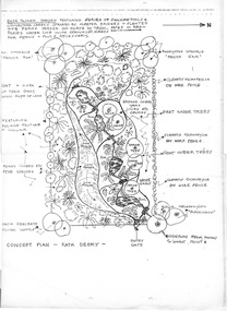
Plan, Kath Deery, Concept Plan - Kath Deery - Bush Tucker Garden, C. 1980
-
University of Melbourne, Burnley Campus Archives
Plan - Planting Design, Vireya Rhododendrons, 2015
vireya rhododendrons, garden plan, plant list -
 Mrs Aeneas Gunn Memorial Library
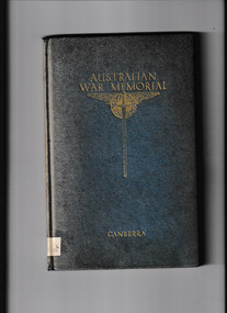
Book, Australian War Memorial, Guide to Australian War Memorial, 1945
A guide to the Australian war memorial in CanberraIll, plans, p.114.A guide to the Australian war memorial in Canberraaustralia - war memorials, australia - military museums -
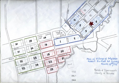 Melton City Libraries
Map, Plan for the Village of Melton, 1853
Site of early village Section numbers 1 - 17 Later became the Flat known as the Common Robert Russell – Surveyor Pinkerton, Sherwin, Bryan, Pyke, Yuille, CollyerMelton Town 1853 Plancouncil -
University of Melbourne, Burnley Campus Archives
Plan (Item), Pavilion, Horticultural Gardens, Burnley
pavilion, burnley gardens, burnley horticultural college -
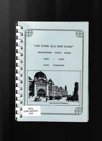 Victorian Railway History Library
Book, Jack Cranston, On time all the time: Melbournes cable trams 1885-1940, ????
Illustrations and plans of Melbournes cable trams 1885-1940.Ill, plans, p.67.non-fictionIllustrations and plans of Melbournes cable trams 1885-1940.urban transportation - melbourne, cable trams - melbourne -
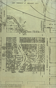 Federation University Historical Collection
Plan, Camp Street Ballarat Parish Plan
Camp Street was the site of the original goldfields camp reserve, and it is from here that soldiers and police troopers left to attack the Eureka Stockade on 03 December 1854.PLan of Camp Street Ballaratcamp street, police reserve, old colonists' association, grenville street, lydiard street north, t. cowan, r. surtees, c.m. watson, w.h. foster, j.b. humffray, j.j. goller, h.r. caselli, henry caselli, market reserve, e.v. gribble, old colonists' association of ballarat -
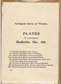 Bendigo Historical Society Inc.
Book - MCCOLL, RANKIN AND STANISTREET COLLECTION: PLATES TO ACCOMPANY BULLETIN NO.49 MALDON GEOLOGICAL SURVEY OF VICTORIA
Book; Brown paper containers with plates (& maps) to accompany bulletin No49 of geological survey of Victoria. V Oswalds G.M. Plan of lease. VI. Oswalds G. M. Plan of workings. VII. Oswalds G. M. Transverse Sect. VIII. Oswalds G. M. Longit. Section. IX. Oswalds G. M. Plan & Sect. 500ft. Level. X. Northey's Reef plan & sections. XI. Carlisle and Whittaker's Mine Plan & Sections.XII. Goldsborough G. M. Co. Gordon's Reef, Plan & Section. XIII. Mount Tarrengower Tunnel Plan & Section.MCCOLL RANKIN & STANISTREETorganisation, industry, surveys, mccoll rankin & stanistreet -
Kew Historical Society Inc
Plan - Charteris Estate, Ivanhoe [East], 1927
Subdivision plans and real estate flyers/brochures reveal a number of aspects of urban development and history. The Kew Historical Society's collection of these plans, as well as advertisements extracted from magazines, cover key aspects of community development and architectural history of Kew and Kew Eat as well as surrounding suburbs. While most of the plans in the collection were gifted to the Society by the former City of Kew, a number of other plans and advertisements have been donated by individuals, of which this is an example.Original 4-page bifold handout advertising 43 residential lots for sale in the Charteris Estate subdivision in Ivanhoe [now classified as Ivanhoe East]. This brochure was created to sell the third section of the estate which it labels as 'The Most Superb Section'. Streets within the subdivision include: Burke Road North, McArthur Road, Castella Street, and the Government Boulevard. In addition to the overall plan spread across pages 2 and 3, each page includes a number of interesting photographs including: a number of the new Burke Road Bridge, a sports ground, Hoyts Picture Theatre in Ivanhoe, a croquet ground, and Ivanhoe shopping centre [named Motor Cross Junction].charteris estate - east ivanhoe (vic), subdivision plans -- ivanhoe east (vic.), d.c. mcarthur, charterisville -
 Federation University Historical Collection
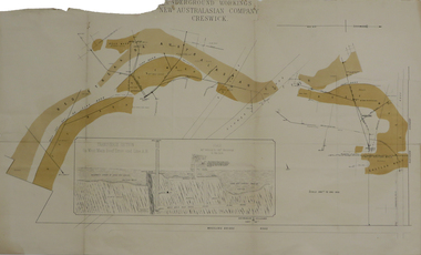
Plan, Underground Workings New Australasian Company Creswick, not dated
... plans ...A plan of the underground working of the New Australasian Mine at Creswick, showing Wheeler's Bridge Road, a transverse section on the West Main Reef Drive and Line AB. It als shows the locations of the Red streak or Australasian Gutter, Reef wash, Eastern Wash, Australasian and Eaglehawk Shaft and prospecting drives.mining, plans, cgt, creswick, new australasian company, wheeler's bridge, red streak gutter, australasian gutter, reef wash, eastern wash, australiasian shaft, eaglehawk shaft -
 Kew Historical Society Inc
Plan - Subdivision Plan, Windella-Darnley Subdivision, Studley Park, 1920s
Subdivision plans are historically important documents used as evidence of the growth of suburbs in Australia. They frequently provide information about when the land was sold on which a built structure was subsequently constructed as well as evidence relating to surveyors and real estate and financial agents. The numerous subdivision plans in the Kew Historical Society's collection represent working documents, ranging from the initial sketches made in planning a subdivision to printed plans on which auctioneers or agents listed the prices for which individual lots were sold. In a number of cases, the reverse of a subdivision plan in the collection includes a photograph of a house that was also for sale by the agent. These photographs provide significant heritage information relating house design and decoration, fencing and household gardens.Version 2 of two subdivision plans (the earlier is 2016.0305.1) for the section of Studley Park Road near the Junction on the south side. Named in the subdivision are the mansions of Darley and Windella (now demolished). Before the subdivision of Darley and Windella, both houses fronted Studley Park Road. Both houses appear to be advertised as lots in the subdivision. Bisecting the subdivision is a street, Antrim Avenue that was never constructed. A street, which was subsequently constructed in this vicinity, was Merrion Place, which now runs between Studley Park Road and Highfield Grove. There are 13 proposed lots in this subdivision in contrast to the earlier plan. This resulted from larger lots being proposed for Studley Park Road.subdivision plans - kew, studley park, windella, darnley, antrim avenue -- kew (vic.), studley park road -- kew (vic.), merrion place -- kew (vic.), merrion grove -- kew (vic.), highbury grove -- kew (vic.) -
 Kew Historical Society Inc
Photograph - Cottage, probably East Kew, A. Aberline, 1920s
The Kew Historical Society's map collection includes a substantial number of real estate subdivision plans, mainly of Kew but also of surrounding suburbs in Melbourne. Most of the subdivision plans date from the 1920s and 1930s when the districts old homes and local farmland were being split up to accommodate residential growth in the postwar period. These early plans were assembled by a local firm, Jas R Mather & McMillan, which had an office in Cotham Road. Many of the plans, and sometimes photos, were annotated by the agents.Subdivision plans are historically important documents used as evidence for the growth of suburbs in Australia. They frequently provide information about when the land was sold as well as evidence relating to surveyors and real estate and financial agents. The numerous subdivision plans in the Kew Historical Society's collection represent working documents, ranging from the initial sketches made in planning a subdivision to printed plans on which auctioneers or agents listed the prices for which individual lots were sold. In a number of cases, the reverse of a subdivision plan in the collection includes a photograph of a house that was also for sale by the agent. These photographs provide significant heritage information relating house design and decoration, fencing and household gardens.The photograph may also be aesthetically significant depending on the importance of the photographic atelier.An elevated, modest weatherboard house, photographed towards the end of the construction phase. The lower section of the weatherboards are exposed and stained. The upper section is rendered with rough-cast. The tiled roof has a single gable that extends over the centrally placed front porch. On the porch, the door and single sidelight are filled with coloured leadlight whereas the casement windows in the front rooms contain plain glass. The leadlight and the wrought iron of the verandah are the only decorative elements of the utilitarian design. The location of the house, which was advertised for sale, has not to date been identified. The real estate photograph is mounted on the reverse of a subdivision plan for the Harvest Home Estate, Kew East.Photographer's stamp, lower right on mount: "A. Aberline, Glenferrie"houses - kew, bungalows - kew, real estate photographs -
 Kew Historical Society Inc
Photograph - Bungalow, probably East Kew, 1920s
The Kew Historical Society's map collection includes a substantial number of real estate subdivision plans, mainly of Kew but also of surrounding suburbs in Melbourne. Most of the subdivision plans date from the 1920s and 1930s when the districts old homes and local farmland were being split up to accommodate residential growth in the postwar period. These early plans were assembled by a local firm, Jas R Mather & McMillan, which had an office in Cotham Road. Many of the plans, and sometimes photos, were annotated by the agents.Subdivision plans are historically important documents used as evidence for the growth of suburbs in Australia. They frequently provide information about when the land was sold as well as evidence relating to surveyors and real estate and financial agents. The numerous subdivision plans in the Kew Historical Society's collection represent working documents, ranging from the initial sketches made in planning a subdivision to printed plans on which auctioneers or agents listed the prices for which individual lots were sold. In a number of cases, the reverse of a subdivision plan in the collection includes a photograph of a house that was also for sale by the agent. These photographs provide significant heritage information relating house design and decoration, fencing and household gardens.The photograph may also be aesthetically significant depending on the importance of the photographic atelier.An unusual bungalow that does not conform to a particular architectural style but which contains eclectic elements of the style of varying periods. The most striking element of the design is the cantilevered veranda that is supported by heavy chains that are attached to the central gable. This deep gable extends across most of the façade, forming an extensive veranda. Parts of this are infilled with screens. Seven wooden posts, whose lower halves are encased in rendered brick pillars, support this gabled veranda. The roof would appear to be covered with corrugated iron. The location of the house, which was advertised for sale, has to date not been identified. The real estate photo is on the reverse of a plan for the Myrtle Hill Subdivision, Kew.bungalows - kew, architecture - 1920s, real estate photographs -
Federation University Historical Collection
Plan, Ballarat - Mining Lease No 5611
Plan showing mining lease no 5611 along Yarrowee Creek, Ballarat. Bonshaw Pre-Emptive Right is recorded on the plan.ballarat, yarrowee, yarrowee creek, mining, mining lease, ballaarat, bonshaw, magpie, pre-emptive right -
 Flagstaff Hill Maritime Museum and Village
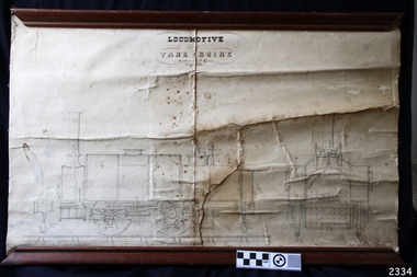
Plan
Plan of locomotive tank engine drawn by A. Kerr 1852. This plan is attached to canvas, and has wooden rails, top and bottom.flagstaff hill, warrnambool, shipwrecked-coast, flagstaff-hill, flagstaff-hill-maritime-museum, maritime-museum, shipwreck-coast, flagstaff-hill-maritime-village, locomotive tank engine, a. kerr -
 Bendigo Historical Society Inc.
Administrative record - EASTER FAIR SECRETARY RECORDS, 2001
CD containing Bendigo Easter Fair secretary records for years 2001,2002, and 2003. Management Plans, financial and planning records.bendigo, institutions, easter fair -
Port Melbourne Historical & Preservation Society
Plan - Port Melbourne Yacht Club reconstruction, Taylor Howden Pty Ltd, Architects, c. 1990
Clubhouse burned 14 February 1990 and was rebuilt with volunteer labour over many years (opened 1998)Plan of Port Melbourne Yacht Club clubhouse reconstruction 1990 Plan of clubhouse prior to 1990; faded almost to illegibilitybuilt environment - recreational facilities, societies clubs unions and other organisations, port melbourne yacht club, pmyc -
Port Melbourne Historical & Preservation Society
Plan - Port Melbourne Yacht Club reconstruction, Taylor Howden Pty Ltd, Architects, c. 1990
Clubhouse burned 14 February 1990 and was rebuilt with volunteer labour over many years (opened 1998)Plan of Port Melbourne Yacht Club clubhouse reconstruction 1990 - PMYC site and location plan; faded almost to illegibilitybuilt environment - recreational facilities, societies clubs unions and other organisations, port melbourne yacht club, pmyc, taylor howden pty ltd -
 Bendigo Historical Society Inc.
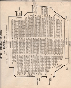
Document - ROYAL PRINCESS THEATRE COLLECTION: SEATING PLANS
Seven sheets of paper showing plans of stalls, box plan and dress circle plann of the Royal Princess Theatre - Bendigo.bendigo, buildings, princess theatre -
Lakes Entrance Regional Historical Society (operating as Lakes Entrance History Centre & Museum)
Book, Department of Conservation and Environment, Wilderness Special Investigation Final Recommendations, 1991
An approved management plan relating to the public foreshore land between Lake Bunga and Mill Point. Contains plans and appendices.waterfront, vegetation -
Whitehorse Historical Society Inc.
Legal record - Illustration, Display Centre
Architect's outline plans of Display Centre for Schwerkolt Cottage. IArchitect's outline plans of Display Centre for Schwerkolt Cottage. Includes elevations and plan. Differs in detail from final building.Architect's outline plans of Display Centre for Schwerkolt Cottage. Ischwerkolt cottage & museum complex, architect plans -
University of Melbourne, Burnley Campus Archives
Plan, Duck Pens at Burnley Competitions. Plan of Floor No 1, c. 1940
Hand drawn plan, coloured. Plan of Floor of Duck Pens with Level for Drain. Imperial measurements, so before 1966.duck pens, drainage