Showing 27529 items
matching rd ?
-
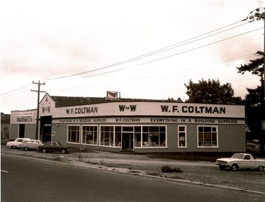 Ballaarat Mechanics' Institute (BMI Ballarat)
W.F. Coltman Creswick Road
1960s, ballarat, coltman, creswick rd -
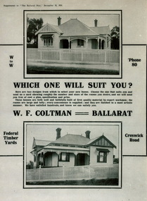 Ballaarat Mechanics' Institute (BMI Ballarat)
Coltman Advertisement
w.f coltman, advertisement, ballarat, federal timber yards, creswick rd -
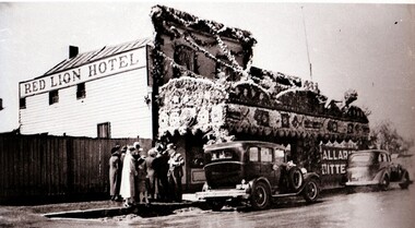 Ballaarat Mechanics' Institute (BMI Ballarat)
Red Lion Hotel
This photograph is from the Max Harris Collection held by the Ballaraat Mechanics' Institute. Please contact BMI for all print and usage inquiries.ballarat, main rd, red lion, hotel -
 Bendigo Historical Society Inc.
Map - SANDHURST (PART), Circa 1880's
Map: Parish plan showing the area Specimen Hill Road and Inglewood St. ( number 222 in Map Cupboard 1)map, bendigo, parish plan, specimen hill rd. inglewood st. -
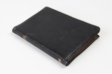 Uniting Church Archives - Synod of Victoria
Book - Bible, Holy Bible, 1920
Mrs Emily Lord gifted £1500 to the building construction which had a total cost of £2000.Soft black dimpled leather covered bible with gilt page edges. There is a calligraphic inscription in coloured ink inside the front cover."To My Friend Emily Lord in happy remembrance of Laying Of Foundation Stone Barkers Road Kew Sunday School by "Mother" November 9th 1935"barkers rd methodist church, barkers road kew sunday school, emily lord -
 Uniting Church Archives - Synod of Victoria
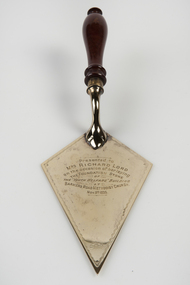
Ceremonial object - Commemorative Trowel, c1935
Gold plate on silver plated EPNS kite shaped commemorative trowel with a turned wooden handle with an engraved inscription. The trowel is in a blue cardboard box."Presented to Mrs Richard Lord on the occasion of her laying the foundation stone of the "Youth Welfare" building at Barkers Road Methodist Church. Nov. 9th 1935"mrs richard lord, barkers rd methodist church -
 Whitehorse Historical Society Inc.
Photograph, Vermont Corner Canterbury and Boronia Roads Vermont
Black and white photo of Vermont corner showing the State Schoolvermont corner, canterbury rd. vermont, vermont state school -
 Whitehorse Historical Society Inc.
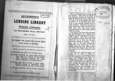
Document - Photocopy of Bookmark, Beckwith's Lending Library, late 1950's, 1950's
Record of the Beckwiths Lending Library, Mitcham2 pg of A4 photocopies non-fictionRecord of the Beckwiths Lending Library, Mitchamlibraries, whitehorse rd mitcham no 503 -
 Bialik College
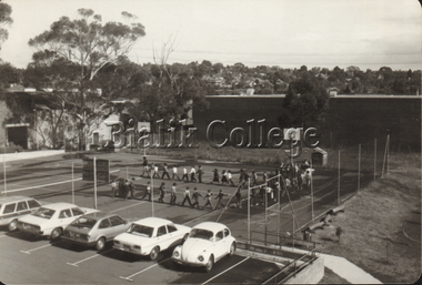
Photograph (Item) - Sports class, c. 1980s, c. 1970s
Students in sports class on the basketball courts, with carpark in the foreground, c. 1980s. Please contact [email protected] to request access to this record.sport, 1980s, auburn rd -
Bialik College
Photographs, Dignitaries at the official opening of the Smorgon Family House building, 16 August 1981, 1981
Dignitaries at the official opening of the Smorgon Family House building, 16 August 1981. Please contact [email protected] to request access to this record.hawthorn, 1980s, event, auburn rd -
Bialik College
Document (collection) - Papers of architect Ron Unger
redevelopment, buildings, construction, auburn rd, shakespeare grove, architecture, planningredevelopment, buildings, construction, auburn rd, shakespeare grove, architecture, planning -
 Ballarat Tramway Museum
Photograph - Colour Print, 1960's
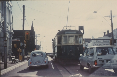
Yields information about a Melbourne tramcar that was to be later collected by the Museum, when it was operating in Melbourne.Colour print of MMTB W3 661 in Glenferrie Road, at intersection with Burwood Road, Hawthorn 1960's? Photo Clive Gibson. Tram does not have a destination box - possibly being transferred to Preston or another depot. Has the Oscar Prowse building in the background. Printed on Kodak Paper.On rear in ink "On behalf of Clive M Gibson & Ron Scholten"trams, tramways, w class trams, glenferrie rd, tram 661 -
 Ballarat Tramway Museum
Photograph - Digital image, late 1910's
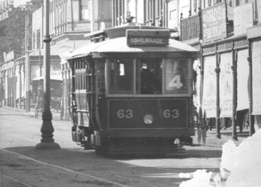
Yields information about a PMTT tramcar that was sold to Ballarat and an operating member of the BTM fleet.Digital Image of Prahran and Malvern Tramway Trust, Maximum Traction tramcar No. 63 in Glenferrie Road, with destination of Esplanade and Route No. 4 in the window of the tram. Tram later became Ballarat No. 18. In the background are shops, centre poles and blinds on the shops, indicating a summer's day perhaps. Detail from a Rose Series postcard. Possibly late 1910's. See image 2 for original enlarged postcard and high res images. Advised by Mal Rowe that he obtained from the Bob Prentice collection. trams, tramways, pmtt, glenferrie rd, tram 63, tram 18 -
 Ballarat Tramway Museum
Photograph - Black & White Photograph/s
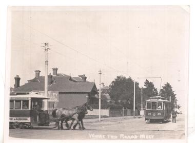
Black & white photo ex Postcard? titled 'Where two roads meet', showing a horse tram ( Hawthorn Bridge to Auburn Road (Riversdale Road) and Prahran and Malvern No. 36 on Glenferrie Road with Deepdene destination, at the intersection of Riversdale & Glenferrie Roads, Hawthorn. Corner block (SE) behind photo has a 'For Sale' sign on it, with houses in background. Now a block of shops. Tram No. 36 is an F class car, later renumbered - see p14 of Destination City, 4th edition. See also inscriptions. Questions: How horse tram number determined and date of photograph??`` Reimaged 17/7/2017 both front and back.'T101, No. 26 horse tram of Hawthorn Tramway Trust in Riversdale Road. No. 36 toastrack (enclosed cross seat) of the Prahran & Malvern Trams in Glenferrie Road, Hawthorn 1917. Horse trams ran from Auburn Road to Hawthorn Bridge and connected with the Richmond cable trams. W.Jack.'trams, tramways, pmtt, horse trams, riversdale road, glenferrie rd , tram f 36 -
 Apollo Bay Museum
Audio - Olive and Gordon Currie Oral History, Apollo Bay April 2023
Local Otways residents (Gadubanud Country) were interviewed by artist/researcher Amy Tsilemanis for the 2023 storytelling project Heart Maps, a collaboration with the Apollo Bay Museum and Historical Society. Themes include memories of communication technologies, entertainments, school, work, community, and life near the ocean. More information here: https://amytsilemanis.com.au/portfolio/heart-mapsapollo bay, farming, killala rd -
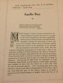 Apollo Bay Museum
Audio - Elderslie Guesthouse tourism booklet
Reading of tourism booklet for the Heart Maps projectapollo bay, elderslie guesthouse, tourism, great ocean rd -
 City of Kingston
Negative - 35mm, black and white, c. 1910
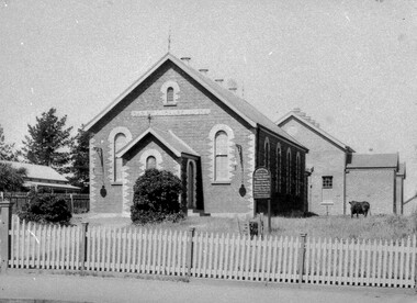
Image 1a and 1b - Church of Christ, located in Chesterville Road, Cheltenham. Images 2a and 2b - Pioneer Presbyterian Church, Scots Church, located in Charman Road, Cheltenham Images 3a and 3b - Shopping strip located on Charman Road, Cheltenham, c.1918 Images 4a and 4b - A cricket team, located in Cheltenham Images 5a and 5b - Cheltenham Cricket Team, photographed outside St Matthew's Church. Back row: E. McSwain, R. Woff, S. Cullen, F. Bodley, T. Chandler, C. Warne, A. Organ, J Monk. Middle Row: C. Roberts, A. Hewett, S. Chandler, F. Chandler, A. Chandler. Front Row: A. Beulke, F. Groves Images 6a and 6b - Cheltenham Rifle Club Committee Opening Day of the new Butts. Back row: C Irwin, E. W. Proudman (Chemist), F T LePage, Centre: W Lamb Smith (Captain), E T Penny, G. Stayner, One unknown gentleman, Front: John Butler, city inspector, and E C Rippon (Manager of the Cheltenham and District Co-operative). A strip of 35mm black and white negative film of six photographs. rifle club, cricket, cheltenham cricket club, charman rd, church, cricket club, shopping strip, horse, cow, sport, team, cars -
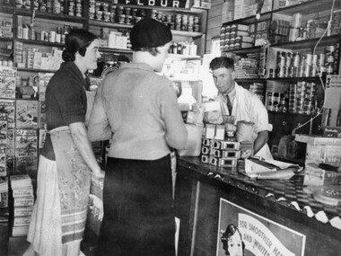 City of Kingston
Photograph - Black and white, c.1930
This photograph shows Judd's Grocery Shop located at 224 Charman Road, Cheltenham in the 1930's. Alan Hutchins is the shop attendant, serving two patrons; Merle Judd (left) and Marion Elliott (right). Judd's Grocery Shop was opened by Clarence Judd in the 1920's and was a successor to the family's business formerly located on the corner of Centre and East Boundary Roads, East Bentleigh. Cheltenham had become an established village during the 1920's and Charman Road represented a second, more commercial development in the area. Black and white photograph of a grocery shop interior displaying a variety of items for sale. A male stands behind a counter, looking at the camera. Two females stand in front of the counter facing the male. One female is wearing a hat. Handwritten in blue ink: 181 Handwritten in red ink: 72%shopping, strip shopping, cheltenham, charman rd, grocery -
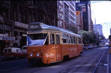 Melbourne Tram Museum
Slide - Set of 11, Tram 1041, 1973/1974
Set of 11 colour slides of PCC car 1041 taken during its early operations around Melbourne. Where the slide has a printed date, it is listed. 1 - Collins St, between Elizabeth St and Swanston St, route 47, Depot - Sept. 1973 2 - Batman Ave in Swanston St, route 15, with W2 383 alongside - Sept. 1973 3 - Elizabeth St terminus with Flinders St station in the background - route 19, North Coburg - Sept. 1973 4 - Arriving Batman Ave terminus, route 70, - Sept. 1973 5 - ditto 6 - Bourke St Mall, route 96 East Brunswick - during a trial closure of Bourke St between Elizabeth Street and Swanston Street , given the seats outside Buckley's store - Nov. 1973 7 - Night photo - TMSV slide - MP166 8 - turning from Glenferrie Road into High St - route 6 Glen Iris - a very tight turn - TMSV slide 9 - Wattle Park terminus, route 70 - 1974 10 - Flinders St -route 74 near William St with the railway viaduct in the background. 1974 11 - Interior photo - Ron Scholten - 1973Yields information about PCC car 1041, a prototype all electric tramcarSet of 11 Kodachrome colour slides, cardboard mounts.tramways, pcc class, tram 1041, collins st, elizabeth st, batman ave, st kilda rd., glenferrie road, wattle park, flinders st, interior, bourke st, route 19, route 70, route 74, route 15, route 47, w2 class, tram 383, route 6, route 96, trams -
 Melbourne Tram Museum
Document - Report, "Future Development of Tramways in the Melbourne Central Business District", Apr. 1973
Six paged duplicated paper or report titled "Future Development of Tramways in the Melbourne Central Business District", by Graeme Breydon, presented to the AETA 1973 Convention, based on an article prepared for the August 1972 issue of Electric Traction. Has references, looks at proposals for underground part of the Swanston St tramway, alternatives for flinders St and a Yarra crossing, St Kilda Road issues, William St, CBD problems and travel issues, shortcomings of proposals, alternatives, Flinders Gate interchanges, associated track improvements, cost benefit ratios, comments and conclusions. 2nd copy contains within a brown manila quarto sized folded marked "Tramways in the Melbourne. Central Business District" G. Breydon (Aug. 1972). See also Reg Item 3069 and 2812 for further references. .2 - letter - c Jan 1973 - carbon copy of a Letter to the Editor for response to a letter in Electric Traction Dec. 1972 responding to H. Moses and making specific comments. .3 - letter - 29/1/1973 to Graeme Breydon from the Ian Cooper of the AETA responding and accepting an offer of Graeme to present on the Board's plan for the forthcoming AETA Canberra Conference in April 1972. .4 - Report - 17 Quarto pages, stapled on the left hand side titled "Future Development of Melbourne Tramway System, with particular reference to possible improvements to the fixed plant of the Central Business District", written by Graeme Breydon, dated Jan. 1972. Refers to the 1962 report of Risson, and scheme presented to Council, Has hand drawn maps of the central area of Melbourne, Looks at the background, traffic issues, proposed underground loop, employment distribution, an extension to Elisabeth St, reversing loops, St Kilda Road and comments on the MMTB proposals. Refers to a paper delivered by D Lees, MMTB Planning Engineer, Swanston St underground proposal,on outside of the 2nd copy, and on top right hand corner of paper AETA Library mark "4E11"trams, tramways, mmtb, melbourne, traffic control, swanston st, st kilda rd, elizabeth st, bourke st, aeta, transportation, underground tramways -
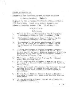
 Melbourne Tram Museum
Poster, Malvern Shopping Centre, 1950's?
Poster titled "Melbourne and Metropolitan Tramways Board - Tram services from North South East and West take you to the Malvern Shopping Centre" Prepared on a Dyeline drawing base and then hand coloured using a draftsman's wash in red for tram lines and green for the shopping centre. Shows the various main roads, tram lines, and rail lines. Has a compass drawn on it. No date - presumed 1950'sctrams, tramways, malvern, glenferrie rd, shoppers -
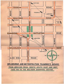
 Melbourne Tram Museum
Ephemera - Ticket/s, Reproduction of a PMTT 2 pence 1916 ticket, 1991
Reproduction of a PMTT 2 pence 1916 ticket, for the White Horse Road Extension Mont Albert - from Burke Road, issued as part of the 75 years of Kew Tram Depot, 1991. On the rear of the ticket are the details of the celebrations, supported by the Tramways Union and ticket from the archives of the TMSV. Has a Kew Tram Depot celebratory stamp on the rear.trams, tramways, kew depot, celebrations, pmtt, mont albert, burke rd -
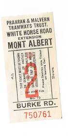
 Melbourne Tram Museum
Photograph - Framed Photographs, c1990
Framed photograph Malvern Driver Ron Scholten's driving W6 917 on a route, East Malvern Darling Road, route 3, in St Kilda Road, c1990. Has St Patricks Cathedral and the Gas and Fuel towers in the background. Has a tram stop sign on the right hand side of the photograph. The tram has two advertisements on the side. Photograph by David Featherston. Received with a broken sheet of glass.On rear in pencil "Photo David Featherston"trams, tramways, swanston st, st kilda rd, tram stops, tram 917 -
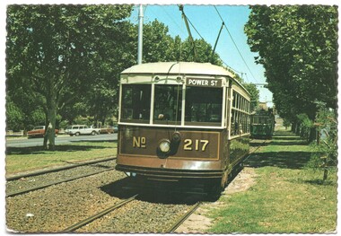 Melbourne Tram Museum
Postcard, Birney Tram 217 in Dandenong Road, c1980, c1980's
Postcard - full colour with serrated edge - Nu-color-Vue - co produced with the TMSV - of Birney Tram 217 in Dandenong Road, c1980. Tram has the destination of Power St with an L class tram 104 behind. The rear is printed in brown ink - card number NCV 739, with place for stamp. gives detail of the tram, the photograph location, the TMSV logo and the Nucolorvue on the left hand side.trams, tramways, postcards, birney, tmsv, l class, dandenong rd, power st, tram 104, tram 217 -
 Melbourne Tram Museum
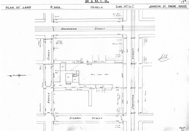
Drawing, "Johnston St Engine House", "Northcote Engine House", "Richmond Engine House", c1938
Set of four photocopied plans or drawings on A3 sheet of the "Johnston St Engine House", "Northcote Engine House" and "Richmond Engine House", c2/1938. .1 - Sheet 1 - P8498 - Plan showing land and surrounding streets for the "Johnston St Engine House" .1 - Sheet 2 - P8499 - Plan showing the layout of the engine house. Has a note sheets 1 and 2 that it has been sold .2 - P8506 -Plan showing land and surrounding streets for the "Northcote Engine House" - 2 copies held. .3 - P8607 - Plan showing Richmond Engine House and adjacent streets with sub-station next doortrams, tramways, drawings, depots, property, cable trams, winding houses, johnston st, northcote, richmond, hoddle st, bridge rd -
 Melbourne Tram Museum
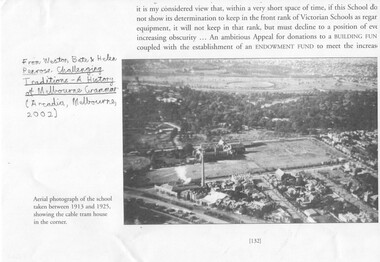
Document - Photocopies, "Challenging Traditions - A History of Melbourne Grammar', 2016
Set of three photocopies of photographs from "Challenging Traditions - A History of Melbourne Grammar (Arcdia, Melbourne 2002) showing the cable tram winding house on the corner of St Kilda Road and Bromby St in 1919 and after redevelopment c1930. .1 - looking north with steam coming from the winding house. .2 - looking south east with winding house and surround buildings .3 - after closure and redevelopment of the site, looking north east. .4 - photo of the intersection of Victoria Parade and Gisborne St showing the cable tram track, cable trams, MFB and Eye and Ear Hospital. Shows the track layout partly. A photograph from a book "Melbourne from the Air"trams, tramways, st kilda rd, cable trams, victoria parade, brunswick st, winding houses, fitzroy -
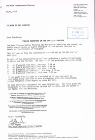
 Melbourne Tram Museum
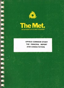
Document - Report, "Upfield Corridor Study - The Principal Report - For Consultation", Dec. 1988
Report - 50 A4 pages contained within heavy green card covers with The Met logo on the top, white comb bound titled "Upfield Corridor Study - The Principal Report - For Consultation". Published by the Metropolitan Transit Authority, Planning Division, Dec. 1988. Has a table of contents and list of tables and figures. Looks at the conversion of the Upfield Rail line to light rail, options for both rail and tram, affects on road traffic. Provides a summary.trams, tramways, upfield light rail, sydney rd, north coburg, conversion -
 Melbourne Tram Museum
Document - Report, "Public Transport in the Upfield Corridor", May. 1989
Consultative report - 8 A4 pages, stapled in the top right hand corner, titled "Public Transport in the Upfield Corridor". Prepared by Ove Arup Transportation Planning, dated May 1989. Provides an outline of the consultation process, dates, gives an outline of the options for the corridor, social costs, access to facilities, shoppers and business, costs and benefits. Two copies held. Second copy stamped 31/5/1989 -WMR Registry HDV.trams, tramways, upfield light rail, sydney rd, north coburg, conversion -
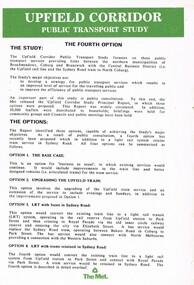 Melbourne Tram Museum
Pamphlet, "Upfield Corridor Public Transport Study", early 1989
Pamphlet - two A4 sheets - may not have been issued at the same time, titled "Upfield Corridor Public Transport Study", looking at a fourth option for the Upfield line. Lists the four options and gives details of the 4th option - retaining a tram services in Sydney Road between Bell Street and Park St during business hours. Notes the consultative period has been extended to June 1989, gives advice that Ove Arup Transportation Planning has been recently appointed, prior appoints and contact details.trams, tramways, upfield light rail, sydney rd, north coburg, conversion -
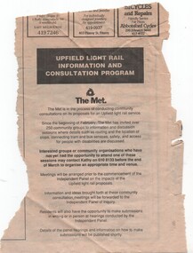 Melbourne Tram Museum
Newspaper, "Upfield Light Rail Information and Consultation Program", 1990
Newspaper clipping possibly from a local newspaper advertising that an Independent Panel of Inquiry has been formed and details will be published shortly. Advising that community group meetings have been held and that further are available. Titled "Upfield Light Rail Information and Consultation Program" On the rear has an advert for the election of Gerry Hand to the Federal seat of Melbourne.trams, tramways, light rail, upfield light rail, conversion, sydney rd