Showing 6760 items matching " rivers"
-
 National Vietnam Veterans Museum (NVVM)
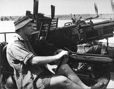
Photograph, Gibbons, Denis, Bofors Gun
Denis Gibbons (1937 – 2011) Trained with the Australian Army, before travelling to Vietnam in January 1966, Denis stayed with the 1st Australian Task Force in Nui Dat working as a photographer. For almost five years Gibbons toured with nine Australian infantry battalions, posting compelling war images from within many combat zones before being flown out in late November 1970 after sustaining injuries. The images held within the National Vietnam Veterans Museum make up the Gibbons Collection. A black and white photograph of Engineer crew of L/C Vernon Sturdie man a Bofors Gun on the Mekong River. The L/C had come under RPG fire from the river bank. photograph, bofor gun, gibbons collection catalogue, mekong river, landing craft vernon sturdie, engineers, denis gibbons -
 Orbost & District Historical Society
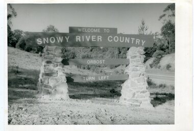
black and white photographs, second half 20th century
These photographs are pictorial records of the signs at the Orbost town entry points.Three black / white photographs. 3277.1 is a sign on stone pillars at the top of a hill - "WELCOME TO SNOWY RIVER COUNTRY ORBOST TURN LEFT". 3277.2 shows a road leading into a town. There is a sign on the left - "ORBOST" and a service station on the right. 3277.3 shows a row of newly planted trees between a road and a school.3277.1 on back - "WELCOME TO SNOWY RIVER COUNTRY - ORBOST sign - Princes Highway - Newmerella" 3277.2 on back - "East Gippsland Shire Sign on eastern approach to ORBOST., in Salisbury Street, near Orbost Secondary College" 3277.3 on back - "Tree planting in Salisbury St, Orbost in front of Orbost High School looking west towards Orbost township"photographs-orbost orbost-township-entry salisbury-street-trees town-entry road-signs-orbost -
![The Erskine River Waterfall / [by] Nicholas Caire, circa 1876](/media/collectors/550653872162f11fb04854aa/items/57831695d0cdd1176c4f24d8/item-media/57831701d0cdd1176c4f989a/item-fit-380x285.jpg) Kew Historical Society Inc
Kew Historical Society IncPhotograph, Anglo-Australasian Photographic Company, The Erskine River Waterfall, c. 1876
Nicholas Caire was born on Guernsey in the Channel Islands in 1837. He arrived in Adelaide with his parents in about 1860. In 1867, following photographic journeys in Gippsland, he opened a studio in Adelaide. From 1870 to 1876 he lived and worked in Talbot in Central Victoria. In 1876 he purchased T. F. Chuck's studios in the Royal Arcade Melbourne. In 1885, following the introduction of dry plate photography, he began a series of landscape series, which were commercially successful. As a photographer, he travelled extensively through Victoria, photographing places few of his contemporaries had previously seen. He died in 1918. Reference: Jack Cato, 'Caire, Nicholas John (1837–1918)', Australian Dictionary of Biography.An original, rare photograph from the series 'Views of Victoria: General Series' by the photographer, Nicholas Caire (1837-1918). The 60 photographs that comprise the series were issued c. 1876 and reinforced a neo-Romantic view of the Australian landscape to which a growing nationalist movement would respond. Nicholas Caire was active as a photographer in Australia from 1858 until his death in 1918. His vision of the Australian bush and pioneer life had a counterpart in the works of Henry Lawson and other nationalist poets, authors and painters.‘The Erskine River waterfall’ : Views of Victoria (General Series) No.52 : Albumen silver photograph | Photo on card with Title and Description on reverse | Mounted 24 x 30 cm; Photo 12 x 17 cm.On Reverse: ‘The River Erskine, which empties itself into Loutitt Bay, is noted for the grandeur of its scenery. Its sources, owing to the impenetrability of the bush and the mountainous nature of the country, are unknown. They may eventually be traced a long way into the Cape Otway Ranges. An idea of the difficulty with which the present very beautiful illustration was obtained may be gained from the fact that it took our assistants, several days to convey the apparatus a distance of six miles and back. The depth of the fall is 150 feet. The foliage as seen comprises the very rare staghorn tree, the myrtle, the dogwood tree, and ferns.’nicholas caire (1837-1918), lorne (vic), erskine river (vic), landscape photography -
 Kiewa Valley Historical Society
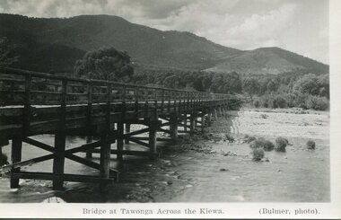
Photograph - Bridge at Tawonga 1936, 22/03/1936
First Tawonga bridge was built in 1884- destroyed by floods in 1916. New bridge constructed 1923 and destroyed in 1953. Present concrete bridge constructed in 1986 and named Ryders BridgeBridge construction over Kiewa River at TawongaBlack and white photographic postcard of the bridge at Tawonga across the Kiewa River.Handwritten in pencil on rear of photograph - Sunday 22nd March, 1936. Printed on front - Bridge at Tawonga across the Kiewa (Blumer, photo)tawonga bridge, kiewa valley -
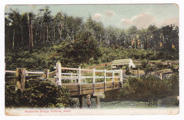
 Marysville & District Historical Society
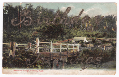
Postcard (item) - Colour tinted postcard, Nicholas John Caire, Marysville Bridge, Victoria, Austr, 1878-1904
One of a series of postcards of photographs taken by socialite photographer Nicholas John Caire.One of a series of postcards of photographs taken by socialite photographer Nicholas John Caire. N.J. Caire had a great love for the area in and surrounding Marysville and in the late 1800's took many photographs of Marysville and its surrounds. N.J. Caire was born in 1837 in Guernsey. He arrived in Adelaide about 1860 along with his parents who encouraged his early interest in photography. He opened a studio in Adelaide in 1867 after traveling extensively throughout the Gippsland taking photographs. After marrying in 1870 he moved to Talbot in Victoria until 1876 when he opened a studio in the Royal Arcade in Melbourne. After 1885 N.J. Caire gave up his city work and made his home in South Yarra and devoted the rest of his life to outdoor photography, specializing in the bush, the gullies and the mountains of south-eastern Victoria.Birthday/ Greetings POST CARD This Space may be Used/ for Correspondence The Address Only to be/ Written Here. 88421 Dear Ivy/ Wishing you/ many happy/ returns of/ the day/ from Reggie Miss Ivy Bastian/ Helston/ Fenwick Street/ Nth Carlton c1918 2nd Bridge The postage stamp has been removed. Helen Boach?marysville, victoria, nicholas john caire, bridge scene, 88421, postcard, souvenir -
 Marysville & District Historical Society
Postcard (Item) - Colour tinted postcard, Nicholas John Caire, Marysville Bridge, Victoria, Austr, 1878-1904
One of a series of postcards of photographs taken by socialite photographer Nicholas John Caire.One of a series of postcards of photographs taken by socialite photographer Nicholas John Caire. N.J. Caire had a great love for the area in and surrounding Marysville and in the late 1800's took many photographs of Marysville and its surrounds. N.J. Caire was born in 1837 in Guernsey. He arrived in Adelaide about 1860 along with his parents who encouraged his early interest in photography. He opened a studio in Adelaide in 1867 after traveling extensively throughout the Gippsland taking photographs. After marrying in 1870 he moved to Talbot in Victoria until 1876 when he opened a studio in the Royal Arcade in Melbourne. After 1885 N.J. Caire gave up his city work and made his home in South Yarra and devoted the rest of his life to outdoor photography, specializing in the bush, the gullies and the mountains of south-eastern Victoria.POST CARD This Space may be Used/ for Correspondence The Address Only to be/ Written Here. 88421 Dear Miss McNair./ We arrived home/ quite safely on Sat./ The children met/ us with Fran and/ Auntie Ethel at the/ Circular Quay. All/ were well and real/ glad to have us home/ again. We were so sorry/ we were too late/ for the train. We thought/ we saw Mr Mr McNair walking from/ the train. Love to ????/ Kisses for Ollie from A.M.G. Miss McNair/ Wattle Street/ Bendigo/ Victoriamarysville, victoria, nicholas john caire, bridge scene, 88421, postcard, souvenir -
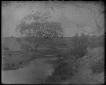 Federation University Historical Collection
Photograph - Glass Plate, Landscape by Henry Sutton
Henry Sutton was born in Ballarat into the musical Sutton Family. He is known as an important Australian inventor. Image of a landscape with river and large tree taken off a glass plate.henry sutton, glass plates, photography -
 Flagstaff Hill Maritime Museum and Village
Document - Navigation Chart, Approaches to Perak River
British Admiralty Navigation Chart - Malacca Straits - Approaches to Perak Riverwarrnambool, shipwrecked-coast, flagstaff-hill, flagstaff-hill-maritime-museum, maritime-museum, shipwreck-coast, flagstaff-hill-maritime-village, shipwrecked-artefact, navigation chart, british admiralty navigation chart, approaches to perak river, malacca straits -
 Phillip Island and District Historical Society Inc.
Photograph, Fishing boat, Penguin, launch on the Yarra River, 1940s
Matte black and white photo of the Penguin being towed on the Yarra RiverNillegg family, fishing boat- penguin, fishing boats -
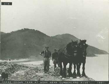 Lorne Historical Society
Photograph, Horse drawn team at work near Cumberland River 1921
Horsedrawn team of two Clydesdale horses and workmen at Cumberland River 1921g.o.r. clydesdale horse team cumberland river 1921 -
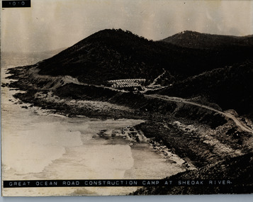 Lorne Historical Society
Photograph, Camp at She Oak River 1930's. G.O.R
Photograph of workers camp at She Oak River circa 1930's she oak river camp site: workers' campsite, sheoak river, workers camp -
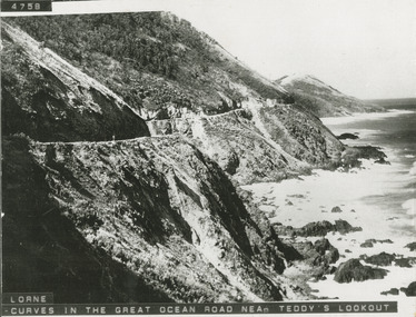 Lorne Historical Society
Photograph, Photograph West of Cumberland River on the Great Ocean Road
Photo showing the curves on the Great Ocean Road west of the Cumberland River/great ocean road: west of cumberland river; -
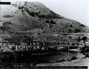 Lorne Historical Society
Photograph, St George River Bridge opening 1926
Photograph showing crowd at the opening of the bridge over the George River in 1926 g.o.r; george river bridge 1926; -
 Glenelg Shire Council Cultural Collection
Postcard - Postcard - Glenelg River, Nelson, n.d
Coloured postcard. Aerial view of the Glenelg River at Nelson, bridge in foregroundnelson, postcard -
Glenelg Shire Council Cultural Collection
Negative - Negative - Glenelg River Nelson Bridge, Victoria, n.d
Transparency for black and white photo - Glenelg River with Nelson Bridge in the distance. -
Glenelg Shire Council Cultural Collection
Painting - Photograph, c. 1963
Sourced from Casterton Town Hall (Former Shire of Glenelg)Same as 7130. Black and white photo of Glenelg River Bridge at Casterton.Back: Black stamp 003826 -
Glenelg Shire Council Cultural Collection
Negative - Negative - Glenelg River, Victoria, 1934
Part of a collection of photographs taken by Zillah Maschmedt in 1934. Zillah was a teacher from South Australia.Negative for black and white photo. Glenelg River and bridge at Nelson, Victoria.zillah maschmedt, photography, glenelg shire, river -
Glenelg Shire Council Cultural Collection
Negative - Negative - Mouth of Glenelg River, Nelson, Victoria, c. 1936
Transparency for black and white photo. Mouth of Glenelg River at Nelson Vic -
Glenelg Shire Council Cultural Collection
Photograph - Photograph - Casterton, Victoria, n.d
SOURCED FROM CASTERTON TOWN HALL (FORMER SHIRE OF GLENELG)Black and white photo. Erosion near Casterton. Car on the banks of riverBack: Round, purple photographer's stampcasterton, glenelg river -
Glenelg Shire Council Cultural Collection
Photograph - Photograph - Casterton, Victoria, n.d
Sourced from Casterton Town Hall (Former Shire of Glenelg)Black and white photo. Same as 7225 (soil erosion, river bank) -
Glenelg Shire Council Cultural Collection
Photograph - Photograph - Casterton, Victoria - Erosion bank, n.d
Sourced from Casterton Town Hall (Former Shire of Glenelg)Black and white photo, same as 7227 (soil erosion, river bank) -
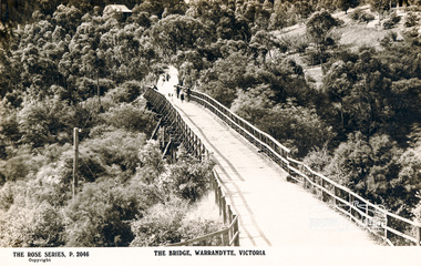 Eltham District Historical Society Inc
Photograph, The Bridge, Warrandyte, Victoria
Postcard showing old timber bridge over Yarra River at WarrandyteThe Rose Series P.2046bridges, yarra river, warrandyte, kangaroo ground road, postcards -
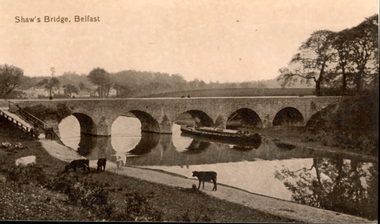 Federation University Historical Collection
Postcard - Sepia, Valentine, Shaw's Bridge, Belfast
A bridge with five arches crossed a river in Belfast. Cows graze in the foreground -
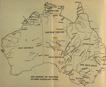 Federation University Historical Collection
Map, Australia Showing Position of Some Australian Tribes, c1945, c1945
Digitised directly from "The Australian Aborigines: How to understand them" by A.P. ElkinMap of Australia showing states, river system and some Aboriginal Tribes.aboriginal, aborigines, kurnai, worworung, wongaibon, wiradjuri, dieri, wakelbura, pittapitta, waramunga, binbinga, anula, mara, waral, mulluk, larakia, worora, djaru, karadjerri, kogara, wongaii, pankala, tabalde, buandie -
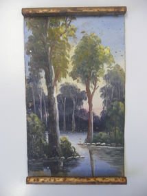 Bendigo Historical Society Inc.
Container - OIL PAINTING ON TIN
Oil painting on tin scroll showing a river scene with Eucalyptus trees.artwork, oil painting, on tin -
 Bendigo Historical Society Inc.
Postcard - POSTCARD. RIVER TORRENS ADELAIDE, 11/03/67
Postcard. River Torrens Adelaide. The Peoples Palace Pirie Street Adelaide. -
Port Melbourne Historical & Preservation Society
Photograph - Various port scenes, 1980s - 1990s
Colour photo of unidentified tug in the river. Unknown person in profile in foregroundpiers and wharves - webb dock, piers and wharves - station pier, transport - shipping -
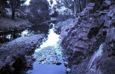 Bendigo Historical Society Inc.
Slide - DAVID MCDONALD COLLECTION: EPPALOCK. CONSTRUCTION, c1963
Eppalock. Construction. Water going down to the Campaspe River from the spillway.Agfacolorcivil engineering, water supply, eppalock -
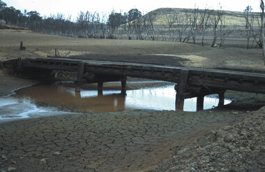 Bendigo Historical Society Inc.
Slide - VAL DENSWORTH COLLECTION: DRY LAKE EPPALOCK, May 2004
Slide. Dry Lake Eppalock. A small bridge over the river in the Lake.slide, bendigo, dry lake eppalock., dry lake eppalock. -
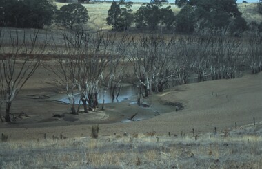 Bendigo Historical Society Inc.
Slide - VAL DENSWORTH COLLECTION: DRY LAKE EPPALOCK, May 2004
Slide. Dry Lake Eppalock. Lagoon in the river surrounded by dead trees.slide, bendigo, dry lake eppalock., dry lake eppalock.