Showing 113084 items
matching road
-
 Whitehorse Historical Society Inc.
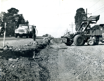
Photograph, Roadworks in Canterbury Road, Forest Hill
Black and white photo of Roadworks in Canterbury Road, Forest Hill. east of Springvale Road in conjunction with C.R.B.canterbury road, forest hill, victoria. country roads board -
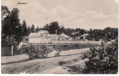
 Whitehorse Historical Society Inc.
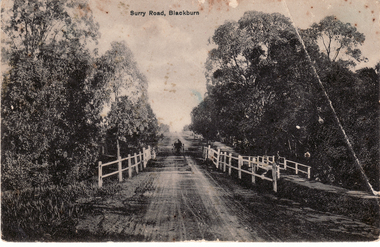
Postcard, Surry (Sic) Road, Blackburn
Black and white Postcard entitled Surry (sic) Road, Blackburn. Shows unmade road, bridge and jinker.surrey road, blackburn. -
 Whitehorse Historical Society Inc.
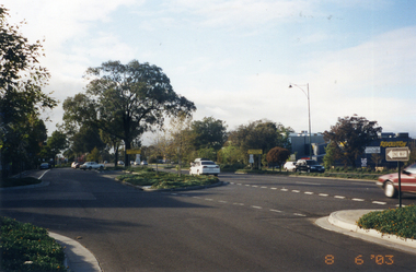
Photograph, Whitehorse Road, Mitcham
Coloured photo of Whitehorse Road looking east from the corner of Doncaster East Road. Taken 2003whitehorse road, mitcham -
 Ringwood and District Historical Society
Article - Newspaper Clipping, Land Sale Advertisements, Golden Hill Estate, Ringwood - 1965, 1966, and Plan of Survey of Lot 8, Mullum Mullum Road Ringwood, 1970
Newspaper clippings from Melbourne Sun newspaper (11th December 1965 and 15th January 1966) advertising sale of land - Golden Hill Estate, Ringwood, with summary of features and aerial photograph including artistic representation of street layout. Subdivision includes Mullum Mullum Road, Sonia Street, Jill Court, Linda Drive, Eve Court, Alma Court, and Jacynthe Court. Attachments include reference to Lot 46 as site of original Peter Vergers' orchard residence and subsequent 1970 surveyor's Plan of Survey of Lot 8 Mullum Mullum Road Ringwood, LP 67513, Cert of Title 8581/429.Agent - Aaron, King & Co., Suite 2, 33 Queens Road, Melbourne. (Phone) 26-2443, A.H. 850-2195. Plan of Survey signed on 25.7.1970 by Roger M. Gamble, Land Surveyor, 28 Summit Crescent, Ringwood 3134. -
 Coal Creek Community Park & Museum
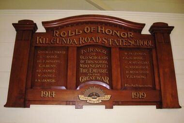
Honour Roll, Kilcunda Road School Honor Roll
This WWI Honor Roll was originally displayed in the Kilcunda Road State School (no.3337), which was located at the north east corner of the intersection of the Bena - Kongwak and Buchanans' Roads, Bena, Victoria, 3946. The school was located amongst the cypress trees at 645 Bena-Kongwak Road. The school was relocated in 2008 to the Coal Creek Community Park and Museum, 12 Silkstone Road, Korumburra, 3950 to become the Masonic Lodge building in the park display. On the west side of the intersection of the Bena - Kongwak and Buchanans' Roads is a brass plaque on a granite boulder with the following inscription TO COMMEMORATE THE DISTRICT OF KILCUNDA ROAD First Surveyed 1879. This is the site of the KILCUNDA ROAD UNITING CHURCH 1911 to 1966. Diagonally opposite at 645 Bena-Kongwak Road was the site of the KILCUNDA ROAD PRIMARY SCHOOL No: 3337, 1902 to 1975. Erected by The School Mother’s Club continuing as The Kilcunda Road Social Club 2008. One of the few remaining historic items from Kilcunda Road settlement.Honour roll of varnished wood, with three panels, an undulating shaped pediment, plain columns at sides, painted gold text and the Australian Imperial Forces insignia on base.Roll of Honor, Kilcunda Road State School. In Honor of Old Scholars of this school who served the Empire in the Great War, 1914-1919, Australian Imperial Force. (X) These made the supreme sacrifice. Sister J.E. Turner , E.N. Barge, E.F. Binding (X), E.H. Bunn, D. James (X), W.James, A. James (X), R. H. James, A.G. Rose (X), C.W. Stanlake, G. Wuchatsch, R. Wuchatsch, T.E. Young kilcunda road, honour roll, state school no.3337., wwi -
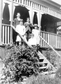 Surrey Hills Historical Society Collection
Photograph, McPhie children, of 5 Suffolk Road, Surrey Hills
5 Suffolk Road was the Mounted Police Station from 1889 - 1914.Image of a five young (school age or younger) children (three boys, two girls) standing on the exterior steps of a building identified as the Mounted Police Station, 5 Suffolk Road, Surrey Hills. The children are identified as the family of Sgt. David McPhie. The children are dressed in 'best clothes.' The main part of the building is not visible however it does have a decorative wooden verandah.people, families, family groups, children, girls, boys, police, policemen, surrey hills mounted police station, structures and establishments, police stations, david mcphie -
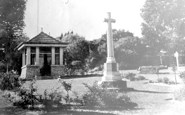 Surrey Hills Historical Society Collection
Photograph, City of Camberwell Council, Surrey Gardens, looking east from Union Road, 1933
The Honor Roll and Shrine in the Surrey Gardens were opened on Sunday 7 April 1918, prior to the cessation of fighting. Mrs Charles H D Steele (MS: Sarah Margaret Russell), president of the local Patriotic League, is credited with the idea of building The Shrine as a fitting memorial to the soldiers of the district. The Surrey Hills Progress Association coordinated raising funds from local residents. John Kendrick Blogg carved the beautiful honor roll in Indian teak and Australian white mahogany and the design of The Shrine was by architectural firm Gawler & Drummond. John Stevens Gawler was a partner in the firm, lived locally and also enlisted. Although he may have been overseas during some of the design process he is often credited with the design. Both men donated their services. The 2 cannons in the gardens were acquired by Mr Arthur Brookes in 1901 to commemorate the end of the Boer War. He was popularly known as 'Empire Brooks' and the cannons as 'Brooks' Babies'. They were originally placed in the grounds of the Guildford Road Recreation Oval. Arthur Brooks was an active community member and one of the founding members of the Surrey Hills Progress Association. Original photo was contained in a booklet printed by Camberwell Council in 1933.This is one of the earliest known photos of 3 elements important in designating the Surrey Gardens as one of the City of Boroondara's heritage gardens, now protected by a heritage overlay. The Shrine was one of the first WW1 memorials to be built in Australia and possibly the first in Victoria. It was unveiled prior to the end of hostilities and was built entirely through local community effort. The design of The Shrine, reflective of domestic architecture, is unusual. Its Honor Roll is also a noted example of sculptor John Kendrick Blogg's work and valued especially for its incorporation of Australian motifs, wattle blossom and gum leaves. The boomerang over the full width of the monument was said to be symbolic of both those who did and did not return. Black and white photo of part of the Surrey Gardens, located between Union Road and Norfolk Road, Surrey Hills. It shows The Shrine, the cannons installed to commemorate the end of the Boer War and the Memorial Cross. Taken from within the park looking east. surrey gardens, shrine of remembrance, monuments and memorials, boer war, mr john kendrick blogg, mr arthur brooks, mrs charles steele, mrs sarah steele, miss sarah margaret russell, cannons, mr john gawler -
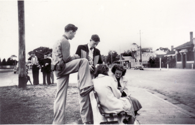 Whitehorse Historical Society Inc.
Photograph, Group at Corner Whitehorse Road and Mitcham Road, 1958
Black and white photo of Group at Corner Whitehorse Road and Mitcham Road. Mitcham Hotel on right.| Two young men nearest camera are:| - Closest is Wally Belfield| - 2nd closest is Laurie O'Rourke.|Directly opposite Opies' Milk Bar and older version of Mitcham's Reserve Hotel.o'rourke, l., mitcham hotel -
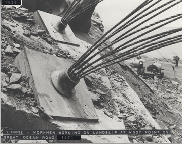 Lorne Historical Society
Photograph, Great Ocean Road. Windy point land slip
1971. This was some of the machinery used in stabilsing the Great Ocean Road between the St George's River and the Sheok River. Holes were drilled in the rock and large cables inserted and concrete forced in around themGreat Ocean Road. This was some of the machinery used in stabilizing the G.O.R. at Windy Point, between the St George River and the Sheoak River. Holes were drilled in the rock and large cables inserted and concrete fixed around them. This took place in late 1971great ocean road. g.o.r. landslip. windy point. 1971 -
![Map, Plan showing proposed deviation of the road through McKenzie's Flat to Bacchus Marsh. [Undated]](/media/collectors/5e461d8021ea67224c82f2a1/items/677d22f37f2053f3e5d500dc/item-media/677d25247f2053f3e5d50950/item-fit-380x285.jpg) Bacchus Marsh & District Historical Society
Bacchus Marsh & District Historical SocietyMap, Plan showing proposed deviation of the road through McKenzie's Flat to Bacchus Marsh. [Undated]
The date of this map or plan is uncertain. McKenzie's Flat is a bushland picnic area on the Lerderderg River in the Lerderderg State Park close to Bacchus Marsh. The proposed road deviation shown on this map is very close to a sharp bend in the Lerderderg River which shows an island in the centre of that bend. The name of a landholder, J.B. Perry is shown on the map close to the area of the road deviation.The land shown is identified as within the Parish of Merrimu.Single page map showing a proposed deviation of the road from McKenzie's Flat to Bacchus Marsh. Scale: 5 chains to 1 inch. Part of a set of maps which are pasted into a bound volume containing 76 maps or plans in total. High resolution digital image stored on BMDHS computer network. mckenzies flat bacchus marsh, bacchus marsh roads and streets -
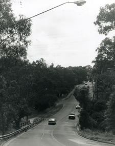 Whitehorse Historical Society Inc.
Photograph, Deep Creek Road, Mitcham, 1/01/2001
Black and white photograph of Deep Creek Road, taken from lower entrance of Schwerkolt Cottage Reserve showing Glenvale Road on left. Taken before work started on new bridge and road.deep creek road, mitcham, glenvale road, ringwood -
 Whitehorse Historical Society Inc.
Postcard, Blackburn Road and Railway Road Blackburn C1908, 1908
Black and white postcard entitled 'Blackburn' Scene shows corner Railway and Blackburn Roads, Albert Street unmade.railway road, blackburn, hooke, janet emily, blackburn road blackburn, albert arthur -
 Whitehorse Historical Society Inc.
Legal record - Land Title, Springvale Road, 1960
Aerial photograph of cnr. Springvale Road and Burwood Highway, south past Highbury Road and east to Vermont South.Aerial photograph of cnr. Springvale Road and Burwood Highway, south past Highbury Road and east to Vermont South.Aerial photograph of cnr. Springvale Road and Burwood Highway, south past Highbury Road and east to Vermont South.aerial photographs, springvale road, burwood east, burwood highway, burwood east, highbury road, burwood east, vermont south -
Whitehorse Historical Society Inc.
Correspondence, Healesville Road, 24/03/1937
Claim for reimbursement from the Country Roads Board of amounts expended on Main Healesville Road by Shire of Blackburn and Mitchamhealesville road, victoria. country roads board, shire of blackburn and mitcham, roads and streets -
Whitehorse Historical Society Inc.
Document - Correspondence, Healesville Road, 9/04/1937
Claim for reimbursement from the Country Roads Board of amounts expended on the Main Healesville Road by Shire of Blackburn and Mitchamhealesville road, shire of blackburn and mitcham, victoria. country roads board, roads and streets -
Whitehorse Historical Society Inc.
Document - Correspondence, Healesville Road, 26/04/1937
Claim for reimbursement from Country Roads Board for amounts expended on Main Healesville Road by Shire of Blackburn and Mitchamshire of blackburn and mitcham, victoria. country roads board, roads and streets, healesville road -
Whitehorse Historical Society Inc.
Document - Correspondence, Healesville Road, 18/06/1937
Claim for reimbursement from Country Roads Board of amounts expended on Main Healesville Road by Shire of Blackburn and Mitchamshire of blackburn and mitcham, victoria. country roads board, roads and streets, healesville road -
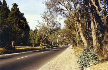 Whitehorse Historical Society Inc.
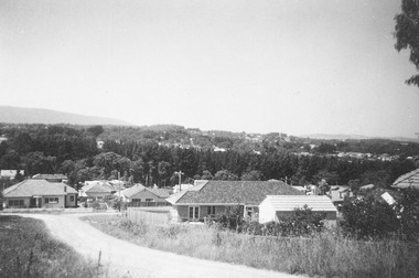
Photograph, Canterbury Road, Vermont, 1967
Part of Tim Shambrook's Collection for 'This is Vermont'. Not used.Coloured photo of Canterbury Road, Vermont, taken in 1967 showing one lane road and heavily treed verge.canterbury road, vermont, shambrook, tim -
 Whitehorse Historical Society Inc.
Photograph, Brunswick Road, Mitcham, 8/09/1958 12:00:00 AM
Black and white photo of Brunswick Road, Mitcham. (Was previously Northcote Road.) Comments as for Forster Street Mitcham. - NP1075.o'rourke, l. -
 Glen Eira Historical Society
Album - Album page, Bureel (Kooyong Road), Circa 1972
This photograph is part of the Caulfield Historical Album 1972. This album was created in approximately 1972 as part of a project by the Caulfield Historical Society to assist in identifying buildings worthy of preservation. The album is related to a Survey the Caulfield Historical Society developed in collaboration with the National Trust of Australia (Victoria) and Caulfield City Council to identify historic buildings within the City of Caulfield that warranted the protection of a National Trust Classification. Principal photographer thought to be Trevor Hart, member of Caulfield Historical Society. Most photographs were taken between 1966-1972 with a small number of photographs being older and from unknown sources. All photographs are black and white except where stated, with 386 photographs over 198 pages. From: Glen Eira Heritage Management Plan 1996 by Andrew Ward In 1856, John Allee, a builder from Brighton, purchased C.A. 37 on the south-west corner of Glenhuntly and Kooyong Roads. The land comprised just over 45 acres. By 1863, Francis John Sidney Stephen, a lawyer and cousin of J. Wilberforce Stephen, owned most of lot 37. By 1866, Stephen had a built a "small mansion" named ''Burreel". It was a brick house and Stephen lived there until 1882. By 1884, Mrs Buxton of Hillside Terrace, East Melbourne, had purchased the property. Richard Buxton, a gentleman was listed as occupant and the house described as "brick, eight rooms". NAV was £300. Richard Buxton continued residency in 1887 however in 1888, George Allen, music seller, became occupant. At that time the house had thirteen rooms on twenty-three acres of land. Twelve people lived there and NAV was £920. In 1900, Daniel Luxton, stock and sharebroker and the Honourable John Taverner, M.H.A. leased the property. Fourteen people lived there. Mrs Buxton continued as owner. By 1910, ownership had passed to Mrs Mary Neate, who converted the house to a nursing home. The land had been subdivided by 1913 and sold by ''Buxtons Estate". Burreel Avenue, Baxter, Buxton and Hoddle Streets were created. "Burreel" was rated to Burreel Avenue and stood on lot 13 with frontages to Burreel Avenue and Kooyong Road of 198' and 214'. The house had ten rooms. NAV was £60. Mary Neate, a nurse, continued as owner/ operator of ''Burreel" nursing home in 1927. At that time there were sixteen rooms and fourteen residents. NAV was £100. Mrs Neat remained there until 1947. In 1948, the house was turned into apartments. In the 1980's, the Alexander family purchased it and restored it to a private residence.Burreel 331 Kooyong Road, ELSTERNWICK VIC 3185 - Property No B4950 National Trust https://vhd.heritagecouncil.vic.gov.au/places/65648 This is a large and substantially intact example of the grand villas of nineteenth century Melbourne. The bulk of the house most probably was built in 1866-1868 for Francis John Sidney Stephen, a prominent and highly regarded Melbourne solicitor and a member of an illustrious legal family. Stephen conducted a lucrative private practice and in 1845 was appointed first solicitor to the City of Melbourne; a position he held until his death in 1895. He took an active part in the development of Caulfield and was Shire President in 1874 and 1877. He was a resident at Burreel from 1868 to 1882. The house has evolved in stages, the rear wings possibly remaining from a house built during the 1850s. The existing ornate cast iron verandah was probably built between 1882 and 1888 during the residence of Richard Buckhurst Buxted, a notable boom period auctioneer and real estate agent. George Allan, the founder of Allan's music store, was another important occupier from 1888 to 1991. Bureel's essentially residential quality has been retained and the interior has been well preserved. The significance of this building does not rest in any single unusual outstanding architectural feature, or in its association with a particularly prominent member of society in the past, but rather in the consistent integrity of both the interior and exterior, which results in the survival of an outstanding example of this type of residential building and its associations with two notable citizens. Classified:11/08/1990Page 113 of photograph album with 1 photograph of Burreel in its garden.Handwritten: Bureel [top left] / 113 [bottom left]trevor hart, caulfield, caulfield north, kooyong road, thomas king, mansion, 1860's, bureel, burreel, francis john sidney stephen, city of melbourne, shire president, 1850's, verandah, nursing home, john allee, ornamented corner stones, new orleans manner, plaster rendered, mrs luxton, vincent willis, alexander family, victorian architectural style, ornate cast iron work, lawyers, brick houses, richard buxton, richard buckhurst buxton, george allen, george leavis allan, allans music, daniel luxton, john taverner, mary neate, buxtons estate, land subdivision, mary neat, gardens -
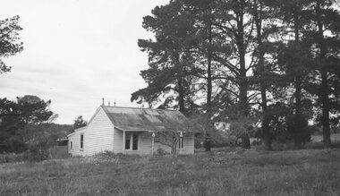 Ringwood and District Historical Society
Photograph, House in Mullum Road (undated)
Weatherboard cottage with tin roof amongst pine trees.Typed below photograph, "House in Mullum Road" -
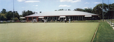 Ringwood and District Historical Society
Photograph, Ringwood Bowling Club- New clubhouse at Loughnan Road, 1997
Colour photograph.The new clubhouse. The synthetic green at Loughnan Road. -
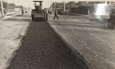 Kew Historical Society Inc
Photograph, City of Kew, Public Works, Road Construction, c.1920s
An original photograph donated to the Kew Historical Society by the City's Engineering Department before the amalgamation of Kew into the City of Boroondara in 1994.While not all of the photographs are of Studley Park, Kew or East Kew, each photo provides a fine snapshot of the work of local government engineering departments of the period. They reveal they types of labour conducted, the techniques used and the equipment and machinery in the possession of the local government authority. Public works. A photograph of a suburban street under construction using a steamroller. Neither the street nor the location has been identified. It is believed that the photograph can be dated to the 1920s. Inscription on reverse: "Road making. (?1920s cars)".steamroller, road construction building, city of kew, city of kew (engineering department) -
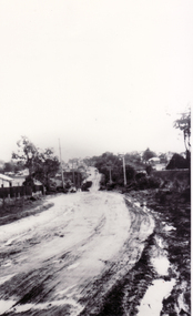
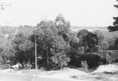 Ringwood and District Historical Society
Photograph, No.14 Glenvale Road, North Ringwood, towards Mitcham. 1982
Written on back of photograph, "21/4/82. No.14 Glenvale Road towards Mitcham. Deep Creek Road in background left." -
 Ringwood and District Historical Society
Photograph, Jewkes pine forest in Mullum Road. Ringwood. 1958
Written next to photograph, "Jewkes pine forest in Mullum Road. Looking down from Wonga Road to Collett Avenue, 1958." -
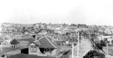 Surrey Hills Historical Society Collection
Photograph, Surrey Hills viewed from 'Quamby' at 293 Mont Albert Road, c 1915, 1915
Quamby was built in 1898. From 1900/1903-1924 it was the home of Andrew Sherar and family. From 1924-1960s it operated as Mosgiel Hospital under the direction of Matron Elizabeth Anderson. Until Box Hill Hospital opened most Surrey Hills children were born at Mosgiel or at Nethercourt Hospital in Wilson Street or later in Union Road when Matron Tank moved her hospital here. Mosgiel Hospital was demolished c 1975 after it was sold by Box Hill Hospital. It was replaced by units. Andrew Sherar was conductor of the Wyclif Church choir for many years and was a member of the Melbourne Liedertafel. Isie Sherar was organist at Wyclif Church and also taught piano in Union Road. Connie Sherar was in the Wyclif choir and married Ernest Swan, an elocutionist and orator. Dorothy Sherar was a pianist and accompanist. Elsie Sherar was also in the Wyclif choir and was a soloist; she later moved to Templestowe. Ken Sherar was a boy soprano at St Paul's Cathedral; he later moved to Queensland.Black and white photo looking south down Vincent Street from 'Quamby', located at 293 Mont Albert Road, Surrey Hills. In the centre foreground is a timber house with 2 chimneys and a tiled hip roof. It has a return veranda and is fenced on 2 sides by paling fences and picket fences on the other two. In the background are many more houses. A road lined with power poles runs from the right foreground to the middle distance.quamby, vincent street, edwardian style, topography, andrew sherar, isie sherar, connie sherar, dorothy sherar, ken sherar, elsie wappet -
Surrey Hills Historical Society Collection
Planning report, City of Boroondara, City of Boroondara planning report re 171 Union Road, Surrey Hills, 19/07/2004
171 Union Road was part of the Thomas Zeplin estate. It originally had a Victorian house on it built by the Zeplin family. This was leased by Dr Percy Liddle and then Dr James Landells Blakie. Dr Blakie purchased land diagonally opposite at 174 Union Road and had a purpose-built home / surgery constructed. Later the site was occupied by COR then a BP petrol station.A detailed proposal regarding the redevelopment of the petrol station site on the corner of Union Road and Montrose Street, Surrey Hills into a 2 storey office and shop building with basement parking and access from Montrose Street. It includes attachments showing plans, elevations and details regarding objectors. The application was granted subject to additional conditions being met. union road, redevelopment, shops, town planning -
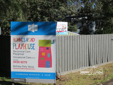 Eltham District Historical Society Inc
Photograph, Liz Pidgeon, Hohnes Road Playhouse, 1 July 2017
Photo taken as part of an EDHS Heritage Excursion - Saturday 1st July - Eltham Lower Park - Walk and Talk. "Eltham Lower Park has played an important part in the history of our area since the early days of European settlement when it was used by local residents as an informal racecourse. Prior to that its location at the junction of the Diamond Creek and the Yarra River made it an important meeting place for the Wurundjeri people. The park combines formal elements and sporting facilities with remnant bushland that is of environmental significance. It is home to sporting and horse riding clubs, popular play spaces and the Diamond Valley Miniature Railway, which attracts large numbers of visitors.The park will be the venue for our July excursion which will comprise a walk of about 3.5 km around the park and adjacent areas. Along the way we will discuss the history and natural history of the area. The path along the creek and the river provides a pleasant and scenic walk.This walk on Saturday 1st July is about 3.5 km in length and will take 2 to 2.5 hours. It will start at 2pm at the Main Road car park at the front of the park. (Melway ref 21 H 10)". Newsletter No., 234, June 2017 Born Digitalheritage excursion, activities, eltham district historical society, eltham lower park, sign, hohnes road playhouse -
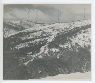 Falls Creek Historical Society
Photograph - Upper Kiewa Valley Road, Falls Creek
MEYER COLLECTION - FALLS CREEK PHOTOS In 1947 a determined group of like-minded State Electricity Commission (SEC) staff including Ray Meyer, the chief surveyor of the Kiewa Hydro-Electric Scheme, had a common interest that revolved around the skiing potential of the snow-covered high plains which included what is now the resort of Falls Creek. The six SEC employees, Toni St Elmo, Ray Meyer, Jack Minogue, Lloyd Dunn, Adrian Ruffenacht and Dave Gibson (together with their families) banded together to secretly build a 'hut' that was the first ski lodge at Falls Creek. Using a road built in 1930s to gain access to Falls Creek, their hut project was carried out in secret as efforts by other skiers were blocked by H.H.C. Williams – the engineer in charge of the Hydro Scheme. In 1946 Ray Meyer made a trip to the Lands Office in Melbourne. He came away with a 99-year lease on three acres that was ideally suited for a hut designed by Lloyd Dunn. Adrian Ruffenacht (Design Engineer for the KHS) had suggested where the group should build because of easy access to a spring for water. Much of the building material required was scavenged from derelict huts on the high plains. Due to the need for secrecy, the determined group worked on the hut in the evenings and weekends to avoid detection. During the building period the group had met at Echidna Rock (now known as Eagle Rock) where Skippy St Elmo announced, "This is my favourite ‘Skyline’.” And so the first lodge in the area at Falls Creek Ski Resort came into existence. With the development of the International Poma in the 1970s, the Skyline Lodge, which was sited between the ski-lift’s pole one and pole two, was demolished. However, the legacy of Ray Meyer, Toni St Elmo, Jack Minogue, Lloyd Dunn, Adrian Ruffenacht and Dave Gibson and Skyline lives on in the vibrant atmosphere of Falls Creek Resort. The MEYER COLLECTION documents developments on the Kiewa Hydro Scheme and their life at Falls Creek from the mid 1930s to 1960s.This image is significant because it depicts aspects of the life of a pioneering family of Falls Creek and the founders of "Skyline", the first lodge at Falls Creek.A photo of the Upper Kiewa Valley Road, Falls Creek. Arrows have been marked on the photo to indicate key locations. L to R:- Tony's Old place; Windy Corner: Tony's Preb./ Road.falls creek, toni st elmo, toni beveridge hydrographer -
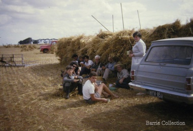 Melton City Libraries
Photograph, Stacking at Ferris Road, Unknown
Hay stacking at Ferris Roadagriculture, local identities