Showing 2754 items
matching 1933
-
 Eltham District Historical Society Inc
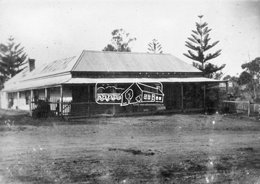
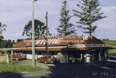
Photograph, C. Wraight's Kangaroo Ground Supply Store, c.1910
Cornelius (Con) and his wife Elizabeth ran the store and post office from about 1904. Their son Donald became involved with the store in the 1930s. A petrol bowser was added in early 1933 and a second in 1937. The Wraights ran the store till the 1940s. Elizabeth died 10 April 1952 and Cornelisu May 30, 1954.This photo forms part of a collection of photographs gathered by the Shire of Eltham for their centenary project book,"Pioneers and Painters: 100 years of the Shire of Eltham" by Alan Marshall (1971). The collection of over 500 images is held in partnership between Eltham District Historical Society and Yarra Plenty Regional Library (Eltham Library) and is now formally known as the 'The Shire of Eltham Pioneers Photograph Collection.' It is significant in being the first community sourced collection representing the places and people of the Shire's first one hundred years.Digital image (negative of original print missing)shire of eltham pioneers photograph collection, kangaroo ground, cornelius wraight, eltham-yarra glen road, general store, kangaroo ground store -
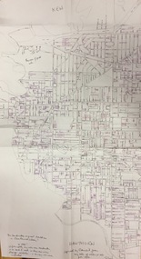
 Kew Historical Society Inc
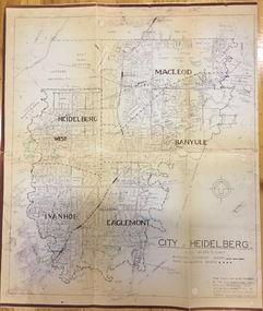
Plan, City Engineers Department (Heidelberg), City of Heidelberg Plan: Scale 20 chns to 1 inch, 1970-1993
Gwen Barton McWilliam (nee: Nelson), OAM, BA (1933- ). Gwen McWilliam is well known as an authority on the history of Boroondara and the author of a large number of books and pamphlets about the City. She was awarded the medal of the Order of Australia in 2001 ‘for service to the community of Hawthorn and district, particularly through the research, documentation and publication of its history.’ Primary source annotated by a distinguished local historian.Plan of number of areas in the City of Heidelberg showing municipal and ward boundaries, subsequently annotated by the historian Gwen McWilliam, identifying significant landholdings, subdivisions and key dates.The base map was printed in 1970 and annotated c.1993. The plan was donated to the Kew Historical Society by Gwen McWilliam. Handwritten annotations by Gwen McWilliam, 1993city of heidelberg, maps -- heidelberg (vic.), gwen mcwilliam -
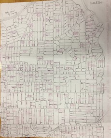
 Kew Historical Society Inc
Plan, Gwen McWilliam, Annotated Plan of Kew & Hawthorn, 1993
Gwen Barton McWilliam (nee: Nelson), OAM, BA (1933- ). Gwen McWilliam is well known as an authority on the history of Boroondara and the author of a large number of books and pamphlets about the City. She was awarded the medal of the Order of Australia in 2001 ‘for service to the community of Hawthorn and district, particularly through the research, documentation and publication of its history.’ Plan of Kew and Hawthorn, forming part of a larger plan of the City of Boroondara, including annotations by the historian Gwen McWilliam, identifying significant landholdings, subdivisions and key dates. The plan was donated to the Kew Historical Society by Ms McWilliam. city of boroondara, subdivisions - hawthorn, subdivisions - kew, gwen mcwilliam -
 Kew Historical Society Inc
Plan, Gwen McWilliam, Annotated Plan of the City of Camberwell, 1993
Gwen Barton McWilliam (nee: Nelson), OAM, BA (1933- ). Gwen McWilliam is well known as an authority on the history of Boroondara and the author of a large number of books and pamphlets about the City. She was awarded the medal of the Order of Australia in 2001 ‘for service to the community of Hawthorn and district, particularly through the research, documentation and publication of its history.’ Plan of Camberwell, Canterbury, Balwyn and Surrey Hills, forming part of a larger plan of the City of Boroondara, including annotations by the historian Gwen McWilliam, identifying significant landholdings, subdivisions and key dates. The plan was donated to the Kew Historical Society by Ms McWilliam. city of boroondara, subdivisions - camberwell, subdivisions - balwyn, subdivisions - surrey hills, subdivisions - canterbury, gwen mcwilliam -
 Kew Historical Society Inc
Plan, Gwen McWilliam, Annotated Plan of City of Boroondara, c.1995
Gwen Barton McWilliam (nee: Nelson), OAM, BA (1933- ). Gwen McWilliam is well known as an authority on the history of Boroondara and the author of a large number of books and pamphlets about the City. She was awarded the medal of the Order of Australia in 2001 ‘for service to the community of Hawthorn and district, particularly through the research, documentation and publication of its history.’ Digitally annotated part plan of the City of Boroondara, created by Council (Library?) staff, based on annotated plans provided by the historian Gwen McWilliam, identifying significant landholdings, subdivisions and key dates. On the plan Gwen McWilliam noted that the attempt to copy her annotations had resulted in incorrect data being included, so the plans were never published. For plans including her original 1993 annotations, see 2017.0143 and 2017.0144.Council markings in pinksubdivisions - hawthorn, subdivisions - kew, subdivisions - camberwell, subdivisions - balwyn, subdivisions - surrey hills, subdivisions - canterbury, gwen mcwilliam -
 Kew Historical Society Inc
Plan, Gwen McWilliam, Annotated Plan of City of Boroondara, c.1995
Gwen Barton McWilliam (nee: Nelson), OAM, BA (1933- ). Gwen McWilliam is well known as an authority on the history of Boroondara and the author of a large number of books and pamphlets about the City. She was awarded the medal of the Order of Australia in 2001 ‘for service to the community of Hawthorn and district, particularly through the research, documentation and publication of its history.’ Digitally annotated part plan of the City of Boroondara, created by Council (Library?) staff, based on annotated plans provided by the historian Gwen McWilliam, identifying significant landholdings, subdivisions and key dates. On the plan Gwen McWilliam noted that the attempt to copy her annotations had resulted in incorrect data being included, so the plans were never published. For plans including her original 1993 annotations, see 2017.0143 and 2017.0144.Council additions in pinksubdivisions - hawthorn, subdivisions - kew, subdivisions - camberwell, subdivisions - balwyn, subdivisions - surrey hills, subdivisions - canterbury, gwen mcwilliam -
 Kew Historical Society Inc
Plan, Gwen McWilliam, Annotated Plan of City of Boroondara, c.1995
Gwen Barton McWilliam (nee: Nelson), OAM, BA (1933- ). Gwen McWilliam is well known as an authority on the history of Boroondara and the author of a large number of books and pamphlets about the City. She was awarded the medal of the Order of Australia in 2001 ‘for service to the community of Hawthorn and district, particularly through the research, documentation and publication of its history.’ Digitally annotated part plan of the City of Boroondara, created by Council (Library?) staff, based on annotated plans provided by the historian Gwen McWilliam, identifying significant landholdings, subdivisions and key dates. On the plan Gwen McWilliam noted that the attempt to copy her annotations had resulted in incorrect data being included, so the plans were never published. For plans including her original 1993 annotations, see 2017.0143 and 2017.0144.Additions in pink by City of Boroondarasubdivisions - hawthorn, subdivisions - kew, subdivisions - camberwell, subdivisions - balwyn, subdivisions - surrey hills, subdivisions - canterbury, gwen mcwilliam -
 Eltham District Historical Society Inc
Photograph - Colour Print, Kangaroo Ground Store, 280 Eltham-Yarra Glen Rd, Kangaroo Ground, 22 July 1993
Cornelius (Con) and his wife Elizabeth ran the store and post office from about 1904. Their son Donald became involved with the store in the 1930s. A petrol bowser was added in early 1933 and a second in 1937. The Wraights ran the store till the 1940s. Elizabeth died 10 April 1952 and Cornelius May 30, 1954.Colour photo print 10 x 15 cm, originally stuck down on corflute for displaycornelius wraight, eltham-yarra glen road, general store, kangaroo ground, kangaroo ground store, kangaroo ground supply store, milk bar, post office, service station -
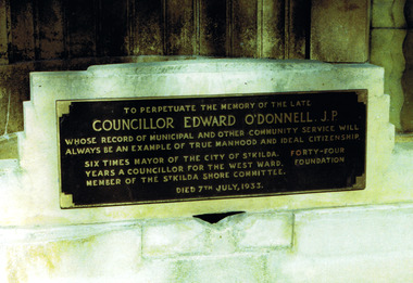 St Kilda Historical Society
Photograph, Plaque commemorating Edward O'Donnell
Plaque in O'Donnell Gardens: memorial to Edward O'Donnell, six times Mayor of St Kildacolour photograph unmountedTo perpetuate the memory of the late Councillor Edward O'Donnell JP whose records of municipal and other community service will always be an example of true manhood and ideal citizenship. 6 times mayor of the City of St Kilda. 44 years a councillor for the West Ward. Foundation Member of the St Kilda Shore Committee. Died 7 July 1933. -
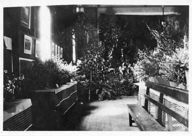 Halls Gap & Grampians Historical Society
Photograph - B/W, C 1938
A photo taken in the Halls Gap Hall at what is said to be one of the best of the early Flower Shows of native flowers. The first flower show was held in 1933 at the suggestion of local resident Jack Watson. Four years later head teacher Grant Greenwood suggested a show be held and due to its success it continues to this day (2010).The photo shows floral displays, arranged on tables along walls and in the centre of a room. There is a bench seat in front of the table in the centre of the room (right side of the photo). Photos and paintings can be seen on the wall on the left side of the photo. "One of the first flower shows Native Flowers Ida Stanton" hand written in pen on back of phto.events, wildflower show -
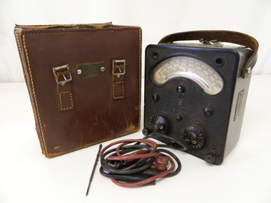 Kiewa Valley Historical Society
Case Leather, circa mid to late 1900's
When this AVOMETER leather case was being utilised in the early 1950's it contained the "leading" edge of electrical measuring instrumentation.The first meter was produced by Automatic Coil Winder and Electrical Equipment Co. in 1923. This model was produced in the time from 1933 to 1951 when it was superseded by the most popular model, Model 8 (1951 to 2008).This leather case which holds its AVO Meter brought the measuring of three electrical power indicators i.e., amps, volts and ohms into one measuring unit. By using a "one fits all" unit, the carrying of separate measuring devices was reduced considerably. The need for a mountainous and a large area of operational requirements, such as the SEC Vic Kiewa Hydro Electricity Scheme, to minimise the weight of equipment carried by electricians and technicians was of the utmost relevance. The significance of this meter to the Kiewa Valley region relates to the impact of modern technology (at that time) upon a mainly rural environment. This equipment shows how the boost of "modern" equipment into the area because of the "Hydro Scheme" was facilitated a lot faster than would have taken under "normal" evolutionary time. The speed of information on all "new technology" had a relatively slow assimilation rate to those living in rural communities. The use of solid leather carrying bags for transporting equipment up and down the mountains provided some form of protection against bumps and dust.This carry case for its AVO meter has an outer leather covering with an inner thick cardboard liner. The case has two mild steel buckles but stitched onto one side but no lid to fasten down. The sides are stitched together with strong tick twine. On either side there are small strap holds. On the bottom are four large chromed metal lugs acting as feet to keep the bottom from lying flat on any floor. The outside bottom has been branded "SOLID COWHIDE"Between the front two buckles is a identification plate riveted onto the cowhide "STATE ELECTRICITY COMMISSION OF VICTORIA ELECTRICAL ENGINEERING SECTION"electrical meters, electrical equipment, sec vic., state electricity commission of victoria, mount beauty, bogong village -
Unions Ballarat
Correspondence with the Central Unemployed Committee, Melbourne. Ballarat Sustenance and Relief Workers' Union, April-October 1939
Ballarat Sustenance and Relief Workers' Union was a Trades Hall Council-sponsored organisation co-ordinating the self help activities of the Ballarat unemployed during the 1930s depression. (1935-1940) Central Unemployed Committee was established in Melbourne by Victorian Trades Hall Council in 1933. The Committee was known to actively lobby against work for the dole schemes.The file forms part of the history of "unemployed unions" during The Great Depression. It also highlights attempts by previous Australian governments to impose "work for the dole" on to unemployed persons in exchange for unemployment benefits. Paper in folder.unemployment, dole, central unemployed committee, victorian trades hall council, btlc, ballarat trades hall, ballarat trades and labour council, work for the dole, ballarat sustenance and relief workers' union, the great depression -
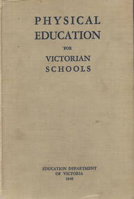 Hume City Civic Collection
Book, Education Department of Victoria, Physical Education for Victorian Schools, 1946
A physical education course of study for primary and secondary school teachersA 480 paged bound text book with a grey cloth cover and navy blue printing on the cover and spine.non-fictionA physical education course of study for primary and secondary school teachers physical education, reference books, schools, teachers -
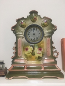 Tatura Irrigation & Wartime Camps Museum
Decorative object - French Mantle Clock
This clock originally belonged to Mrs Helen Cross of Tatura. It may have been a wedding present in 1880. It was handed down to her daughter Mrs W Dick (1933) of Harston, then to her daughter Mrs Ruby Williams (1952) of Tatura and then to her son Brian Williams in 1997. Mrs Cross was formally Miss Brideson of Rushworth. China Mantle Clock with brass face. Decorative edging. Olive Green glaze with pink trim. Floral decorations on front.128 on baseharston, tatura, rushworth, clock -
 Mt Dandenong & District Historical Society Inc.
Photograph, Harmony Vale Homestead
This photograph of 'Harmony Vale' homestead was taken by Daisy Rowse c1917. It is a copy of the original. 'Harmony Vale' was the home built c1860 by early settler Jabez Richardson and his wife Sarah Ann. Jabez Richardson arrived in 1855 with the Child and Jeeves families. The building and barn stood until 1933. The name Harmony Vale was given to the early settlement.Black and white photograph with the roof of a house in centre surrounded by trees. harmony vale, daisy rowse, jabez richardson, richardson, homestead -
 Melton City Libraries
Photograph, George Tinkler, Edna Barrie and Pearl Walker at First Hundred Years Celebration Melton State School 430, 1970
Edna attended Melton State School 430 from 1924 – 1933. Her father Fred had also attended the same school. Edna was also the co-author with Mabel Rogers “The First 100 Years, 1870 – 1970”, and assembled a collection of School Class Photograph and identified and compiled lists of names for future school history. George Tinkler, Edna Barrie and Pearl Walker at First Hundred Years Celebration Melton State School 430. This event was held at Mechanics Hall, Melton.education, local identities, local significant events -
 Bendigo Historical Society Inc.
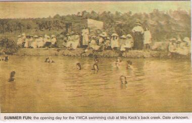
Newspaper - JENNY FOLEY COLLECTION: SUMMER FUN
This photo originally appeared in the "Bendigonian" 20th January 1914. Ada Keck was born in Sandhurst 24/7/1856 to William and Mary Reynolds (nee Williams). In 1906, she married Herbert Keck (1859-1937). Herbert went on to become a MLA. Ada died 14/1/1933 and had had a long association with the YWCA.Bendigo Advertiser ''The way we were'' from 2002. Summer fun: the opening day for the YMCA swimming club at Mrs. Keck's, Back Creek. Date unknown. The clip is in a folder.newspaper, bendigo advertiser, the way we were -
 Kew Historical Society Inc
Plan, Studley Park Estate, 1910
Prue Sanderson, in her groundbreaking ‘City of Kew Urban Conservation Study : Volume 2 - Development History’ (1988), summarised the periods of urban development and subdivisions of land in Kew. The periods that she identified included 1845-1880, 1880-1893, 1893-1921, 1921-1933, 1933-1943, and Post-War Development. These periods were selected as they represented periods of rapid growth or decline in urban development. An obvious starting point for Sanderson’s groupings involved population growth and the associated economic cycles. These cycles also highlighted urban expansion onto land that was predominantly rural, although in other cases it represented the decline and breakup of large estates. A number of the plans in the Kew Historical Society’s collection can also be found in other collections, such as those of the State Library of Victoria and the Boroondara Library Service. A number are however unique to the collection.The Kew Historical Society collection includes almost 100 subdivision plans pertaining to suburbs of the City of Melbourne. Most of these are of Kew, Kew East or Studley Park, although a smaller number are plans of Camberwell, Deepdene, Balwyn and Hawthorn. It is believed that the majority of the plans were gifted to the Society by persons connected with the real estate firm - J. R. Mathers and McMillan, 136 Cotham Road, Kew. The Plans in the collection are rarely in pristine form, being working plans on which the agent would write notes and record lots sold and the prices of these. The subdivision plans are historically significant examples of the growth of urban Melbourne from the beginning of the 20th Century up until the 1980s. A number of the plans are double-sided and often include a photograph on the reverse. A number of the latter are by noted photographers such as J.E. Barnes.Coloured lithograph of a subdivision plan of the Studley Park Estate, bordered by Yarra, Willsmere Road and the Outer Circle Railway line. The estate was listed in 1910 and was the subject of a planning dispute between the developer and the Town of Kew in relation to flood levels and the suitability of the land for housing. In many cases the names of streets were subsequently changed. The layout was also affected by the creation of the Eastern Freeway. A newspaper report of the day described the subdivision as a: "GOLDEN OPPORTUNITY. We are pleased to submit for PRIVATE SALE that magnificent ESTATE, situated only 4 1/2 miles from the Melbourne General Post Office, STUDLEY PARK ESTATE. KF/NV. Doubtless the CHEAPEST LAND EVER OFFERED having extensive frontages to the prettiest spot on the River Yarra and the National Park, commanding lovely river and landscape views, and acknowledged to be the finest land available so close to the city. The PRICES ARE EXTREMELY MODERATE; The TERMS ARE SIMPLY MARVELLOUS. NO DEPOSIT. NO DEPOSIT. NO DEPOSIT. Allotments and prices to suit everyone."subdivision plans - kew, studley park estate -
 Kew Historical Society Inc
Plan, Studley Heights Estate, 1936
Pru Sanderson, in her groundbreaking ‘City of Kew Urban Conservation Study : Volume 2 - Development History’ (1988), summarised the periods of urban development and subdivisions of land in Kew. The periods that she identified included 1845-1880, 1880-1893, 1893-1921, 1921-1933, 1933-1943, and Post-War Development. These periods were selected as they represented periods of rapid growth or decline in urban development. An obvious starting point for Sanderson’s groupings involved population growth and the associated economic cycles. These cycles also highlighted urban expansion onto land that was predominantly rural, although in other cases it represented the decline and breakup of large estates. A number of the plans in the Kew Historical Society’s collection can also be found in other collections, such as those of the State Library of Victoria and the Boroondara Library Service. A number are however unique to the collection.Subdivision plans are historically important documents used as evidence of the growth of suburbs in Australia. They frequently provide information about when the land was sold on which a built structure was subsequently constructed as well as evidence relating to surveyors and real estate and financial agents. The numerous subdivision plans in the Kew Historical Society's collection represent working documents, ranging from the initial sketches made in planning a subdivision to printed plans on which auctioneers or agents listed the prices for which individual lots were sold. In a number of cases, the reverse of a subdivision plan in the collection includes a photograph of a house that was also for sale by the agent. These photographs provide significant heritage information relating house design and decoration, fencing and household gardens.The ‘Studley Heights Estate’ on the South Side of Studley Park Road was launched in 1936. The seventeen allotments in the subdivision fronted Hyton Crescent and Studley Park Road.subdivision plans - kew, studley heights estate -
![Monnington [Estate], 1935](/media/collectors/550653872162f11fb04854aa/items/5907eb86d0ce0c14e82385c8/item-media/5907ecafd0ce0c14e823e87f/item-fit-380x285.jpg) Kew Historical Society Inc
Kew Historical Society IncPlan - Subdivision Plan, Monnington [Estate], 1935, 1935
Pru Sanderson, in her groundbreaking ‘City of Kew Urban Conservation Study : Volume 2 - Development History’ (1988), summarised the periods of urban development and subdivisions of land in Kew. The periods that she identified included 1845-1880, 1880-1893, 1893-1921, 1921-1933, 1933-1943, and Post-War Development. These periods were selected as they represented periods of rapid growth or decline in urban development. An obvious starting point for Sanderson’s groupings involved population growth and the associated economic cycles. These cycles also highlighted urban expansion onto land that was predominantly rural, although in other cases it represented the decline and breakup of large estates. A number of the plans in the Kew Historical Society’s collection can also be found in other collections, such as those of the State Library of Victoria and the Boroondara Library Service. A number are however unique to the collection.Subdivision plans are historically important documents used as evidence of the growth of suburbs in Australia. They frequently provide information about when the land was sold on which a built structure was subsequently constructed as well as evidence relating to surveyors and real estate and financial agents. The numerous subdivision plans in the Kew Historical Society's collection represent working documents, ranging from the initial sketches made in planning a subdivision to printed plans on which auctioneers or agents listed the prices for which individual lots were sold. In a number of cases, the reverse of a subdivision plan in the collection includes a photograph of a house that was also for sale by the agent. These photographs provide significant heritage information relating house design and decoration, fencing and household gardens.The first subdivision of Monnington took place in 1935. At that time, Monnington and 10 new allotments were offered for sale bordering Adeney and Marshall Avenues. In this subdivision plan, Monnington is one of 13 lots for sale. The subdivision created the irregular land holding of Monnington today. The excision of southwest corner of Monninton was caused by the need to have regular allotments facing the curve in Marshall Avenue.monnington - adeney avenue -- kew (vic.), subdivision plans -- kew (vic.) -
 Kew Historical Society Inc
Plan - Subdivision Plan, Goldthorns House Estate, 1940
Pru Sanderson, in her groundbreaking ‘City of Kew Urban Conservation Study : Volume 2 - Development History’ (1988), summarised the periods of urban development and subdivisions of land in Kew. The periods that she identified included 1845-1880, 1880-1893, 1893-1921, 1921-1933, 1933-1943, and Post-War Development. These periods were selected as they represented periods of rapid growth or decline in urban development. An obvious starting point for Sanderson’s groupings involved population growth and the associated economic cycles. These cycles also highlighted urban expansion onto land that was predominantly rural, although in other cases it represented the decline and breakup of large estates. A number of the plans in the Kew Historical Society’s collection can also be found in other collections, such as those of the State Library of Victoria and the Boroondara Library Service. A number are however unique to the collection.The Kew Historical Society collection includes almost 100 subdivision plans pertaining to suburbs of the City of Melbourne. Most of these are of Kew, Kew East or Studley Park, although a smaller number are plans of Camberwell, Deepdene, Balwyn and Hawthorn. It is believed that the majority of the plans were gifted to the Society by persons connected with the real estate firm - J. R. Mathers and McMillan, 136 Cotham Road, Kew. The Plans in the collection are rarely in pristine form, being working plans on which the agent would write notes and record lots sold and the prices of these. The subdivision plans are historically significant examples of the growth of urban Melbourne from the beginning of the 20th Century up until the 1980s. A number of the plans are double-sided and often include a photograph on the reverse. A number of the latter are by noted photographers such as J.E. Barnes.The first subdivision of Goldthorns created the Goldthorns Hill Estate. Following that subdivision, seven additional lots were offered between Normanby Road, Argyle Road and Lady Loch’s Drive on the proviso that the estate, including Goldthorns was not sold as a single lot. The subdivision plan advises that the lots are situated in one of the most charming and popular residential areas in Kew and is surrounded by modern homes. Typically, the subdivision plan proposes the advantage of its proximity to Cotham Road and the tram to Collins Street. Because of the elevation of Goldthorns, much is made of the ‘bright, sunny and extensive outlook to the Northern Ranges’ and that it overlooks the Yarra Valley. One of the more interesting aspects of the plan is that it shows the outline of Goldthorns in the mid to late 1920s. Its profile today remains virtually the same."Goldthorns" House Estate at topsubdivision plans - kew, goldthorns house estate -
 Kew Historical Society Inc
Plan, Sydney Arnold Best & Co, Field Place, Kew, c.1929
Pru Sanderson, in her groundbreaking ‘City of Kew Urban Conservation Study : Volume 2 - Development History’ (1988), summarised the periods of urban development and subdivisions of land in Kew. The periods that she identified included 1845-1880, 1880-1893, 1893-1921, 1921-1933, 1933-1943, and Post-War Development. These periods were selected as they represented periods of rapid growth or decline in urban development. An obvious starting point for Sanderson’s groupings involved population growth and the associated economic cycles. These cycles also highlighted urban expansion onto land that was predominantly rural, although in other cases it represented the decline and breakup of large estates. A number of the plans in the Kew Historical Society’s collection can also be found in other collections, such as those of the State Library of Victoria and the Boroondara Library Service. A number are however unique to the collection.The Kew Historical Society collection includes almost 100 subdivision plans pertaining to suburbs of the City of Melbourne. Most of these are of Kew, Kew East or Studley Park, although a smaller number are plans of Camberwell, Deepdene, Balwyn and Hawthorn. It is believed that the majority of the plans were gifted to the Society by persons connected with the real estate firm - J. R. Mathers and McMillan, 136 Cotham Road, Kew. The Plans in the collection are rarely in pristine form, being working plans on which the agent would write notes and record lots sold and the prices of these. The subdivision plans are historically significant examples of the growth of urban Melbourne from the beginning of the 20th Century up until the 1980s. A number of the plans are double-sided and often include a photograph on the reverse. A number of the latter are by noted photographers such as J.E. Barnes.An unnamed subdivision in Studley Park including five lots for sale in Studley Park Road, Highfield Grove and Tara Avenue. Unidentified on the plan, but clearly existing, are the Henty family mansion of Field Place and Tara Hall in Studley Park Road. The first attempted subdivision of Tara Hall was advertised in 1927 in which Lots 5, 6 and 7 in this plan were also advertised. Unusually, Lot 2 in Studley Park Road was created from the northern part of the Henty mansion, rather than Tara Hall. In the subdivision, lots were advertised at varying prices, with the highest price for land being Lot 2 in Studley Park Road. The plan notes that only one villa is to be allowed on each allotment.subdivision plans - kew, field place subdivision -- studley park – kew (vic.), highfield grove – kew (vic.), tara avenue – kew (vic.) -
 Kew Historical Society Inc
Plan - Subdivision Plan, Altyre Estate, 1920, 1920
Pru Sanderson, in her groundbreaking ‘City of Kew Urban Conservation Study : Volume 2 - Development History’ (1988), summarised the periods of urban development and subdivisions of land in Kew. The periods that she identified included 1845-1880, 1880-1893, 1893-1921, 1921-1933, 1933-1943, and Post-War Development. These periods were selected as they represented periods of rapid growth or decline in urban development. An obvious starting point for Sanderson’s groupings involved population growth and the associated economic cycles. These cycles also highlighted urban expansion onto land that was predominantly rural, although in other cases it represented the decline and breakup of large estates. A number of the plans in the Kew Historical Society’s collection can also be found in other collections, such as those of the State Library of Victoria and the Boroondara Library Service. A number are however unique to the collection.The Kew Historical Society collection includes almost 100 subdivision plans pertaining to suburbs of the City of Melbourne. Most of these are of Kew, Kew East or Studley Park, although a smaller number are plans of Camberwell, Deepdene, Balwyn and Hawthorn. It is believed that the majority of the plans were gifted to the Society by persons connected with the real estate firm - J. R. Mathers and McMillan, 136 Cotham Road, Kew. The Plans in the collection are rarely in pristine form, being working plans on which the agent would write notes and record lots sold and the prices of these. The subdivision plans are historically significant examples of the growth of urban Melbourne from the beginning of the 20th Century up until the 1980s. A number of the plans are double-sided and often include a photograph on the reverse. A number of the latter are by noted photographers such as J.E. Barnes.The Altyre Estate was advertised for sale by auction in 1920. A colour lithograph in the State Library of Victoria, in contrast to this monochrome version, notes the proximity of the subdivision to the Auburn Heights Bowling Club and to a range of transport options. The subdivision included fifty-one allotments as well as the original house ‘Altyre’ in Barkers Road. This version includes the amounts paid as deposit on a number of lots.subdivision plans - kew, altyre estate – kew (vic), barkers road – kew (vic), walsh street – kew (vic), ross street – kew (vic), loxton street – kew (vic), mount street – kew (vic), auburn heights bowling club, altyre -
 Kew Historical Society Inc
Plan - Subdivision Plan, Wimba Estate, Kew, c.1925-c.1929, ca. 1925-ca. 1929
Pru Sanderson, in her groundbreaking ‘City of Kew Urban Conservation Study : Volume 2 - Development History’ (1988), summarised the periods of urban development and subdivisions of land in Kew. The periods that she identified included 1845-1880, 1880-1893, 1893-1921, 1921-1933, 1933-1943, and Post-War Development. These periods were selected as they represented periods of rapid growth or decline in urban development. An obvious starting point for Sanderson’s groupings involved population growth and the associated economic cycles. These cycles also highlighted urban expansion onto land that was predominantly rural, although in other cases it represented the decline and breakup of large estates. A number of the plans in the Kew Historical Society’s collection can also be found in other collections, such as those of the State Library of Victoria and the Boroondara Library Service. A number are however unique to the collection.Subdivision plans are historically important documents used as evidence of the growth of suburbs in Australia. They frequently provide information about when the land was sold on which a built structure was subsequently constructed as well as evidence relating to surveyors and real estate and financial agents. The numerous subdivision plans in the Kew Historical Society's collection represent working documents, ranging from the initial sketches made in planning a subdivision to printed plans on which auctioneers or agents listed the prices for which individual lots were sold. In a number of cases, the reverse of a subdivision plan in the collection includes a photograph of a house that was also for sale by the agent. These photographs provide significant heritage information relating house design and decoration, fencing and household gardens.In 1925, the City of Kew called for tenders for the construction of Wimba Avenue, Cadow Street and Lalla Street. Subsequent advertisements for the sale of land in Wimba Avenue continued from 1926 to 1929. The 18 lots (and a further five allotments on the eastern side of the street) offered for sale were unofficially described in the subdivision plan as the ‘Wimba Estate’. These lots began in Park Hill Road and extended almost to Cotham Road. The subdivision took its name from the house ‘Wimba’ in Cotham Road, which may have formed the southern boundary of the subdivision. (Wimba, at 235 Cotham Road was constructed between 1862-70). The Plan highlights the proximity and advantage of ‘electric’ trams in Cotham and Glenferrie Roads, and the Kew and Glenferrie Railway Stations. An oddity in the Plan is the reference to the electric tram terminus at Burke Road, given that the tramline had already been extended to Mont Albert in 1916.wimba estate, subdivision plans - kew, parkhill road – kew (vic.), normanby road – kew (vic.), wimba avenue – kew (vic.) -
 Kew Historical Society Inc
Plan - Subdivision Plan, Summerhill Estate, 1920-1940
Pru Sanderson, in her groundbreaking ‘City of Kew Urban Conservation Study : Volume 2 - Development History’ (1988), summarised the periods of urban development and subdivisions of land in Kew. The periods that she identified included 1845-1880, 1880-1893, 1893-1921, 1921-1933, 1933-1943, and Post-War Development. These periods were selected as they represented periods of rapid growth or decline in urban development. An obvious starting point for Sanderson’s groupings involved population growth and the associated economic cycles. These cycles also highlighted urban expansion onto land that was predominantly rural, although in other cases it represented the decline and breakup of large estates. A number of the plans in the Kew Historical Society’s collection can also be found in other collections, such as those of the State Library of Victoria and the Boroondara Library Service. A number are however unique to the collection.The Kew Historical Society collection includes almost 100 subdivision plans pertaining to suburbs of the City of Melbourne. Most of these are of Kew, Kew East or Studley Park, although a smaller number are plans of Camberwell, Deepdene, Balwyn and Hawthorn. It is believed that the majority of the plans were gifted to the Society by persons connected with the real estate firm - J. R. Mathers and McMillan, 136 Cotham Road, Kew. The Plans in the collection are rarely in pristine form, being working plans on which the agent would write notes and record lots sold and the prices of these. The subdivision plans are historically significant examples of the growth of urban Melbourne from the beginning of the 20th Century up until the 1980s. A number of the plans are double-sided and often include a photograph on the reverse. A number of the latter are by noted photographers such as J.E. Barnes.The Summerhill Estate was a subdivision in Glen Iris of 24 ‘choice allotments’. The lots were primarily on both sides of Dillon Grove. Other lots at each end of the subdivision faced Margaret Street and Summerhill Road. It was from the latter that the subdivision took its advertised title. The lots were originally advertised for £10 deposit with 20 subsequent payments over five years. Pencilled on the printed plan is a change to the deposit required; a reduction to 20/-. Annotations indicate that the new deposits ranged from 30/- to 45/-. The most expensive lots faced Summerhill Road. This subdivision plan is unusual in that the front and rear of the card are for subdivisions in different localities.subdivision plans - glen iris, summerhill estate -
 Kew Historical Society Inc
Plan - Subdivision Plan, Old Kew Golf Links Estate - Third Section, 1920-1929
Pru Sanderson, in her groundbreaking ‘City of Kew Urban Conservation Study : Volume 2 - Development History’ (1988), summarised the periods of urban development and subdivisions of land in Kew. The periods that she identified included 1845-1880, 1880-1893, 1893-1921, 1921-1933, 1933-1943, and Post-War Development. These periods were selected as they represented periods of rapid growth or decline in urban development. An obvious starting point for Sanderson’s groupings involved population growth and the associated economic cycles. These cycles also highlighted urban expansion onto land that was predominantly rural, although in other cases it represented the decline and breakup of large estates. A number of the plans in the Kew Historical Society’s collection can also be found in other collections, such as those of the State Library of Victoria and the Boroondara Library Service. A number are however unique to the collection.The Kew Historical Society collection includes almost 100 subdivision plans pertaining to suburbs of the City of Melbourne. Most of these are of Kew, Kew East or Studley Park, although a smaller number are plans of Camberwell, Deepdene, Balwyn and Hawthorn. It is believed that the majority of the plans were gifted to the Society by persons connected with the real estate firm - J. R. Mathers and McMillan, 136 Cotham Road, Kew. The Plans in the collection are rarely in pristine form, being working plans on which the agent would write notes and record lots sold and the prices of these. The subdivision plans are historically significant examples of the growth of urban Melbourne from the beginning of the 20th Century up until the 1980s. A number of the plans are double-sided and often include a photograph on the reverse. A number of the latter are by noted photographers such as J.E. Barnes.When the old Kew Golf Links was subdivided in the mid 1920s, the developers were able to break the sale into sections. The third section included eighty lots. The lots faced Kilby Road, Kodak Avenue, Belford Road, Baker Avenue, Mathers Avenue, and White Avenue. [Kodak Avenue was renamed Page Avenue at a later date].The ‘Kew Conservation Study (1988) notes that ‘On the subdivision plan, Kodak’s involvement is commemorated by the naming of the streets after Company directors, and their decision to not proceed with the construction of the factory is explained as a response to the increase in the value of the land. This explanation may have been Estate Agent’s hyperbole, as the Kodak Company records suggest that the land, with its wide creek gully, was unsuitable and too small for its purposes.subdivision plans - kew, old kew golf links estate - third section -
 Kew Historical Society Inc
Plan - Subdivision Plan, Birdwood Estate, 1920
Pru Sanderson, in her groundbreaking ‘City of Kew Urban Conservation Study : Volume 2 - Development History’ (1988), summarised the periods of urban development and subdivisions of land in Kew. The periods that she identified included 1845-1880, 1880-1893, 1893-1921, 1921-1933, 1933-1943, and Post-War Development. These periods were selected as they represented periods of rapid growth or decline in urban development. An obvious starting point for Sanderson’s groupings involved population growth and the associated economic cycles. These cycles also highlighted urban expansion onto land that was predominantly rural, although in other cases it represented the decline and breakup of large estates. A number of the plans in the Kew Historical Society’s collection can also be found in other collections, such as those of the State Library of Victoria and the Boroondara Library Service. A number are however unique to the collection.The Kew Historical Society collection includes almost 100 subdivision plans pertaining to suburbs of the City of Melbourne. Most of these are of Kew, Kew East or Studley Park, although a smaller number are plans of Camberwell, Deepdene, Balwyn and Hawthorn. It is believed that the majority of the plans were gifted to the Society by persons connected with the real estate firm - J. R. Mathers and McMillan, 136 Cotham Road, Kew. The Plans in the collection are rarely in pristine form, being working plans on which the agent would write notes and record lots sold and the prices of these. The subdivision plans are historically significant examples of the growth of urban Melbourne from the beginning of the 20th Century up until the 1980s. A number of the plans are double-sided and often include a photograph on the reverse. A number of the latter are by noted photographers such as J.E. Barnes.Bordering Burke Road, the Birdwood Estate included a subdivision of 34 lots on either side of Birdwood Street, Balwyn. Six of the lots faced Burke Road. At the other end of the subdivision a line would indicate that a creek once bordered the subdivision. Lots were advertised for sale at a low figure on five-year terms. Purchasers could pay off the balance in twenty quarterly instalments (i.e. over five years).subdivision plans - balwyn, birdwood estate -
 Kew Historical Society Inc
Plan - Subdivision Plan, Bonnie Doon Estate, c.1908
Pru Sanderson, in her groundbreaking ‘City of Kew Urban Conservation Study : Volume 2 - Development History’ (1988), summarised the periods of urban development and subdivisions of land in Kew. The periods that she identified included 1845-1880, 1880-1893, 1893-1921, 1921-1933, 1933-1943, and Post-War Development. These periods were selected as they represented periods of rapid growth or decline in urban development. An obvious starting point for Sanderson’s groupings involved population growth and the associated economic cycles. These cycles also highlighted urban expansion onto land that was predominantly rural, although in other cases it represented the decline and breakup of large estates. A number of the plans in the Kew Historical Society’s collection can also be found in other collections, such as those of the State Library of Victoria and the Boroondara Library Service. A number are however unique to the collection.The Kew Historical Society collection includes almost 100 subdivision plans pertaining to suburbs of the City of Melbourne. Most of these are of Kew, Kew East or Studley Park, although a smaller number are plans of Camberwell, Deepdene, Balwyn and Hawthorn. It is believed that the majority of the plans were gifted to the Society by persons connected with the real estate firm - J. R. Mathers and McMillan, 136 Cotham Road, Kew. The Plans in the collection are rarely in pristine form, being working plans on which the agent would write notes and record lots sold and the prices of these. The subdivision plans are historically significant examples of the growth of urban Melbourne from the beginning of the 20th Century up until the 1980s. A number of the plans are double-sided and often include a photograph on the reverse. A number of the latter are by noted photographers such as J.E. Barnes.The subdivision advertised as the Bonnie Doon Estate in Greensborough was first advertised in 1908. At that stage, the new subdivision included 15 allotments of between one and four acres. By the time the subdivision plan in the Kew Collection was created, only 12 lots of between ¾ and 2½ acres remained. Both the State Library and Kew plans emphasise the distance to the city being 13½ miles, which could be reached by train on weekdays and weekends. Unusually, the plan describes the suitability of lots as locations for ‘Week-end Homes’. Correspondingly, the train line is described as ‘The Holiday Resort for the Northern Suburbs’.bonnie doona estate, subdivision plans - greensborough -
 Kew Historical Society Inc
Plan - Subdivision Plan, Cotham Vale Estate, 1919
Pru Sanderson, in her groundbreaking ‘City of Kew Urban Conservation Study : Volume 2 - Development History’ (1988), summarised the periods of urban development and subdivisions of land in Kew. The periods that she identified included 1845-1880, 1880-1893, 1893-1921, 1921-1933, 1933-1943, and Post-War Development. These periods were selected as they represented periods of rapid growth or decline in urban development. An obvious starting point for Sanderson’s groupings involved population growth and the associated economic cycles. These cycles also highlighted urban expansion onto land that was predominantly rural, although in other cases it represented the decline and breakup of large estates. A number of the plans in the Kew Historical Society’s collection can also be found in other collections, such as those of the State Library of Victoria and the Boroondara Library Service. A number are however unique to the collection.The Kew Historical Society collection includes almost 100 subdivision plans pertaining to suburbs of the City of Melbourne. Most of these are of Kew, Kew East or Studley Park, although a smaller number are plans of Camberwell, Deepdene, Balwyn and Hawthorn. It is believed that the majority of the plans were gifted to the Society by persons connected with the real estate firm - J. R. Mathers and McMillan, 136 Cotham Road, Kew. The Plans in the collection are rarely in pristine form, being working plans on which the agent would write notes and record lots sold and the prices of these. The subdivision plans are historically significant examples of the growth of urban Melbourne from the beginning of the 20th Century up until the 1980s. A number of the plans are double-sided and often include a photograph on the reverse. A number of the latter are by noted photographers such as J.E. Barnes.The Cotham Vale Estate was a subdivision of land between Alfred, Thomas, Rowland and John Streets. It was promoted in the same time as the nearby Normanby Heights Estate. Cotham Vale included 28 allotments. Contemporary newspaper advertisements noted that the Estate ‘is most conveniently situated in a well elevated position, only 2 minutes from Cotham rd. Electric Cars, penny section to Kew station’.subdivision plans - kew, cotham vale estate, rowland street -- kew (vic.), thomas street -- kew (vic.), john street -- kew (vic.) -
 Kew Historical Society Inc
Plan - Subdivision Plan, Golf View Estate, c.1922
Pru Sanderson, in her groundbreaking ‘City of Kew Urban Conservation Study : Volume 2 - Development History’ (1988), summarised the periods of urban development and subdivisions of land in Kew. The periods that she identified included 1845-1880, 1880-1893, 1893-1921, 1921-1933, 1933-1943, and Post-War Development. These periods were selected as they represented periods of rapid growth or decline in urban development. An obvious starting point for Sanderson’s groupings involved population growth and the associated economic cycles. These cycles also highlighted urban expansion onto land that was predominantly rural, although in other cases it represented the decline and breakup of large estates. A number of the plans in the Kew Historical Society’s collection can also be found in other collections, such as those of the State Library of Victoria and the Boroondara Library Service. A number are however unique to the collection.The Kew Historical Society collection includes almost 100 subdivision plans pertaining to suburbs of the City of Melbourne. Most of these are of Kew, Kew East or Studley Park, although a smaller number are plans of Camberwell, Deepdene, Balwyn and Hawthorn. It is believed that the majority of the plans were gifted to the Society by persons connected with the real estate firm - J. R. Mathers and McMillan, 136 Cotham Road, Kew. The Plans in the collection are rarely in pristine form, being working plans on which the agent would write notes and record lots sold and the prices of these. The subdivision plans are historically significant examples of the growth of urban Melbourne from the beginning of the 20th Century up until the 1980s. A number of the plans are double-sided and often include a photograph on the reverse. A number of the latter are by noted photographers such as J.E. Barnes.The subdivision advertised as the Golf View Estate in Camberwell included 32 allotments bordering on Glen Iris Road, Smith Street (now Smith Road), St Andries Street and Camberwell Road. In the post-war period in which the subdivision took place, the significance of Camberwell as the ‘Heathiest of Suburbs’ because of the undulating nature of its terrain and its high altitude was promoted. The sales pitch aimed at attracting and selling to ‘Gentlemen’ who could take advantage of the nearby trams, which would take them to the ‘heart of the city’.subdivision plans - camberwell, golf view estate