Showing 25579 items matching "plenty-township-estate"
-
 Whitehorse Historical Society Inc.
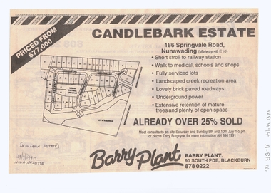
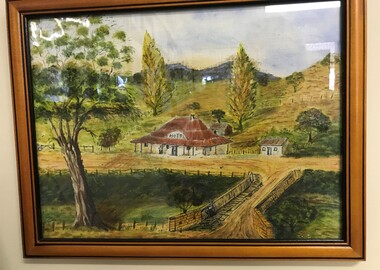
Article, Candlebark Estate, 27/07/1994 12:00:00 AM
Advertisement in Nunawading Gazette for the old Winlaton EstateAdvertisement in Nunawading Gazette for the old Winlaton Estate, Springvale Road, Nunawading being subdivided. Agent Barry Plant. 27 July 1994.Advertisement in Nunawading Gazette for the old Winlaton Estateland subdivision, springvale road, nunawading, candlebark lane, sugargum court, newburn court, barry plant -
 Whitehorse Historical Society Inc.
Document, Heatherdale Road Estate, Unknown
Third subdivision, Heatherdale Road Estate, Mitcham comprising 188 lots. Includes plans, price list and advertising material. 2 copies.brady, john f., heatherdale road, mitcham, purches street, kulnine avenue, culwell avenue, blossom street, nymph street, land subdivision, walwa street -
 Whitehorse Historical Society Inc.
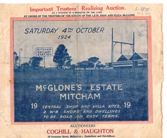
Document, McGlone Estate Mitcham
Pamphlet on auction of McGlone's Estate,Pamphlet on auction of McGlone's Estate, Mitcham 1924. Bordered by McGlone Street, Whitehorse Road, Station Street and Mitcham Railway line and stationPamphlet on auction of McGlone's Estate, land sales, auctions, mcglone estate, mcglone, john, elizabeth, station street, mitcham, whitehorse road, mitcham railway station, coghill & haughton -
 Greensborough Historical Society
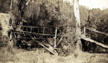
Photograph - Digital image, Rose McLaughlin and others - bridge over Plenty River 1935, 1935_
Rose McLaughlin, Frank Oxley (Cousin of John McLaughlin) Myrtle McLaughlin - Bridge over Plenty River 1935. John McLaughlin and Rosalie Ellen Whatmough came to Greensborough in 1840 from Belfast. These photographs from the collection of Myrtle McLaughlin show friends and relatives from the Greensborough and Plenty area.This photograph shows some of the primitive conditions in the area.Digital copy of black and white photograph.myrtle mclaughlin, rosalie mclaughlin, frank oxley -
 Greensborough Historical Society
Newspaper clipping, Diamond Valley Leader, Enlisting help: stories honour Anzacs; with Yarra Plenty Regional Library flyer advertising Discover your Anzac story program, 26/11/2014
Research by Maureen Jones about Sgt. Reginald Simms and Nurse Elizabeth Gallagher as part of Yarra Plenty Regional Library publication program about people from Nillumbik, Banyule and Whittlesea who served in World War 1. Includes Yarra Plenty Regional Library flyer about the project.Front page colour image and article and image p. 5. Small colour flyer.world war 1, maureen jones, yarra plenty regional library, reginald simms, elizabeth gallagher -
 Greensborough Historical Society
Photograph - Digital Image, Blackjack: Greensborough flats and house on the Plenty River, 1953_
Greensborough flats and house on the Plenty River at Blackjack, the home of the Robinson family to late 1956. The Blackjack property, house and acres of fruit orchards ran down to the Plenty River off Hume Street Greensborough. The photographs were taken as slides by Frank Robinson and digitised by his son James in 2015.Digital copy of colour photograph.blackjack, robinson family, plenty river -
 City of Moorabbin Historical Society (Operating the Box Cottage Museum)
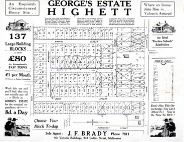
Flyer - George's Estate, Highett
At the end of World War One, there was a renewed interest in residential land and a number of estates opened up in the Municipality of Moorabbin.Example of the progress of the Municipality of MoorabbinAdvertising flyer for auction of real estate sales - plan of building blocks for saleGeorge's Estate Highett - 137 building blocksgeorge street, haynes street, dorothea street, barnett street, rose street, highett road, highett, real estate, auctions -
 Greensborough Historical Society
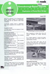
Newsletter, Vic Roads, Vic Roads , Greensborough Bypass Upgrade - Duplication of Plenty River Bridge, August 2005
Vic Roads Newsletter regarding the Greensborough Bypass Upgrade and duplication of the Plenty River Bridge.2 page Newsletter with print and black & white photosgreensborough bypass, vicroads, plenty ri, plenty river bridge -
 Greensborough Historical Society
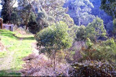
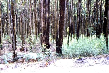
Slide - Photograph, John Ramsdale, Plenty Gorge with blackberries: Slide 87, 1990s
Photograph shows a track through trees and retaining wall. This is Plenty Gorge with blackberries in foreground.Part of the John Ramsdale collection of slides and audio visual material.Colour photograph scanned from slide.No maker's marks. No caption on slide.plenty gorge, blackberries -
 Greensborough Historical Society
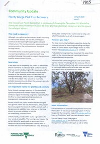
Booklet, Parks Victoria et al, Plenty Gorge Park fire recovery, 15/04/2020
Community update on rehabilitation of the section of Plenty Gorge Park affected by a bushfire in December 20196 p. text and colour photographs and mapplenty gorge park, bushfires, blue lake, yellow gum park, plenty -
 Greensborough Historical Society
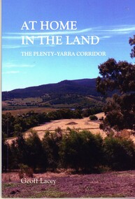
Book, Geoff Lacey, At home in the land: the Plenty-Yarra corridor, 2021
111 p., paperback, col. photographs, mapsnon-fictionindigenous plants, indigenous fauna, plenty river, yarra river -
 Greensborough Historical Society
Slide - Photograph, John Ramsdale, Post bushfire regrowth, Upper Plenty: Slide 31, 1990s
Photograph shows a bush scene with trees that are regenerating after a bushfire in the Upper Plenty area.Part of the John Ramsdale collection of slides and audio visual material.Colour photograph scanned from slide.No maker's marks. Caption on slide "T & Bs"bushfires, upper plenty, vegetation -
 Greensborough Historical Society
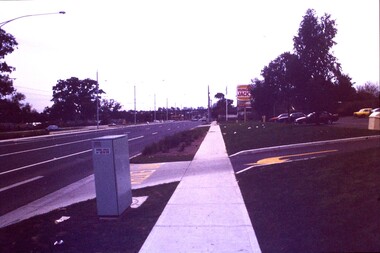
Slide - Photograph, John Ramsdale, Plenty Road: Slide 13, 1990s
Photograph shows a 3 lane road with Hungry Jacks sign - Plenty Road Bundoora.Part of the John Ramsdale collection of slides and audio visual material.Colour photograph scanned from slide.No maker's marks. No caption on slide.plenty road bundoora -
 Greensborough Historical Society
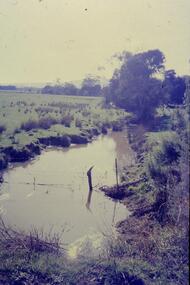
Slide - Photograph, John Ramsdale, Plenty River: Slide 19, 1990s
Photograph shows low water flow on the Plenty River near South Morang or Mernda.Part of the John Ramsdale collection of slides and audio visual material.Colour photograph scanned from slide.No maker's marks. No caption on slide.south morang, mernda, plenty river -
 Greensborough Historical Society
Painting, Lower Plenty Hotel, by Sylvia Jones, 1960-1970
Painted by Sylvia Jones 1960s from a photograph of Lower Plenty Hotel taken 1940s.Oil on canvas painting, framed and glazedlower plenty hotel, sylvia jones -
 Greensborough Historical Society
Photograph - Digital image, Jessie and Gordon Scholes with Tom Vickers, Plenty River, 1943c
Photograph of Jessie Scholes (nee Partington), Gordon Scholes and Tom Vickers at the Plenty River.Digital copy of black and white photograph.jessie scholes, jessie partington, gordon scholes, tom vickers, plenty river -
 Greensborough Historical Society
Photograph, Plenty River Greensborough, 1910c
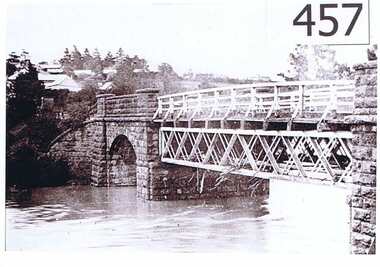
It shows the Plenty river in Greensborough in flood and the bluestone bridge at the bottom of the Main Street hill.The bluestone bridge was built in the mid 1860's and was demolished 1970's.A black and white photograph of a bridge over a river in flood.Nilgreensborough, plenty river, floods, bridges, bluestone -
 Greensborough Historical Society
Photograph - Digital image, Marilyn Smith, Railway Road Rail Bridge over Plenty River Briar Hill, 17/09/2014
Para Road bridge over Plenty River Greensborough, taken from the banks of the river.Digital copy of colour photographpara road greensborough, plenty river -
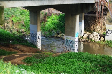 Greensborough Historical Society
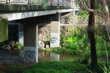
Photograph - Digital image, Marilyn Smith, Railway Road Rail Bridge over Plenty River Briar Hill, 17/09/2014
Para Road bridge over Plenty River Greensborough, showing graffiti on bridge supports.Digital copy of colour photographpara road greensborough, plenty river -
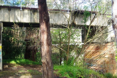 Greensborough Historical Society
Photograph - Digital image, Marilyn Smith, Railway Road Rail Bridge over Plenty River Briar Hill, 17/09/2014
Para Road bridge over Plenty River Greensborough, taken from the banks of the river.Digital copy of colour photographpara road greensborough, plenty river -
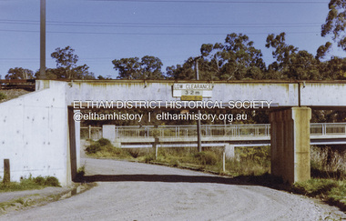
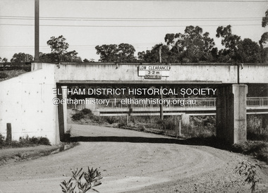 Eltham District Historical Society Inc
Photograph - Black and White Print, Railway Bridge across Plenty River near Railway Road, Briar Hill, Vic, c. August 1977
Para Road bridge across Plenty River can be seen behind railway bridge.Black and white photographinfrastructure, bridge, greensborough, para road bridge, railway road bridge, shire of eltham infrastructure -
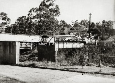
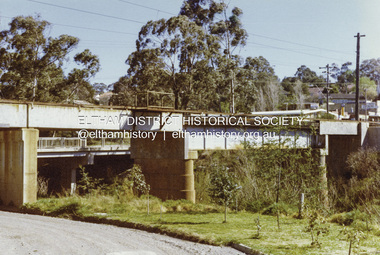
 Eltham District Historical Society Inc
Photograph - Colour Print, Railway Bridge across Plenty River near Railway Road, Briar Hill, Vic, c. August 1977
Para Road bridge across Plenty River can be seen behind railway bridge.Colour photographinfrastructure, bridge, greensborough, para road bridge, railway road bridge, shire of eltham infrastructure -
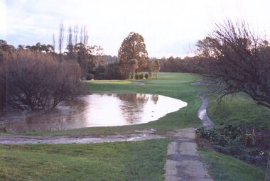 Heidelberg Golf Club
Photograph, Plenty River flooding across 2nd fairway, July 1997, July 1997
Plenty River flooding across 2nd fairway, July 1997, Heidelberg Golf ClubColour photograph of a golf courseheidelberg golf club, 2nd fairway -
 Melbourne Tram Museum
Document - Report, Parliamentary Public Works Committee, "Parliamentary Public Works Committee Report Plenty Road, Preston, Tramway Extension Enquiry, 1967
Report contained within a light brown card folder, containing a photocopy of report titled "Parliamentary Public Works Committee Report (including map) on The Plenty Road, Preston, Tramway Extension Enquiry - 1967". Report stapled in top right hand corner, 15 pages examining the extension of the East Preston route to Bolderwood Parade. Map shows extension proposed, bus routes, railway lines, streets - folded into 4.AETA stamp on front and inside sheet and "4E6" in ink on front cover. AETA stamp on the bottom right hand corner of the map.trams, tramways, east preston, new tramway, bolderwood parade, proposals -
 Greensborough Historical Society
Map, Melbourne and Metropolitan Board of Works. Survey Division, MMBW, Yarra 2500 / 11.21. Bundoora, east of Plenty Road, 1979_01
Melbourne and Metropolitan Board of Works. Yarra 2500 [base map] 11-21. Bundoora, east of Plenty Road. Parish of Keelbundoora 2856, Municipalities of Diamond Valley 257, Preston 225 and Whittlesea 239. Prominent streets include: Grimshaw Street, Settlement Road and Plenty Road. Includes Yulong Park.MMBW Map in 1:2500 [scale] series. Cream parchment with green tape reinforcing on edges and punched holes on left edge.mmbw, melbourne and metropolitan board of works, shire of diamond valley, bundoora - maps -
 Greensborough Historical Society
Map, Melbourne and Metropolitan Board of Works. Survey Division, MMBW, Yarra 2500 / 13.24. Plenty, Memorial Drive, 1979_03
Melbourne and Metropolitan Board of Works. Yarra 2500 [base map] 13-24. Plenty, Memorial Drive. Parish of Morang 3183. Municipalities of Diamond Valley 257 and Whittlesea 239. Prominent streets include: Oatland Road, River Avenue and Memorial Drive. Includes Plenty River and SEC Transmission easement.MMBW Map in 1:2500 [scale] series. Cream parchment with green tape reinforcing on edges and punched holes on left edge.mmbw, melbourne and metropolitan board of works, shire of diamond valley, plenty - maps -
 Greensborough Historical Society
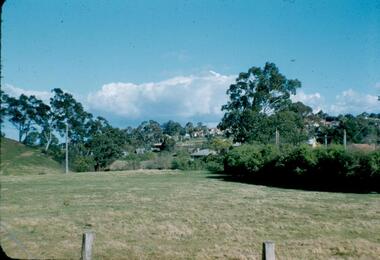
Photograph - Digital image, Frank Robinson, Greensborough near Plenty River bridge and football ground, 1954_
Greensborough near Plenty River bridge and football ground. The Blackjack property, house and acres of fruit orchards ran down to the Plenty River off Hume Street Greensborough and was the home of the Robinson family to late 1956. The photographs were taken as slides by Frank Robinson and digitised by his son James in 2015.Digital copy of colour photograph.robinson family, plenty river, blackjack -
 Greensborough Historical Society
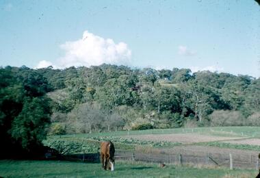
Photograph - Digital image, Frank Robinson, Looking across the Plenty River from Pope's paddock to Blackjack, 1954_
Looking across the Plenty River from Pope's paddock to Blackjack. The Blackjack property, house and acres of fruit orchards ran down to the Plenty River off Hume Street Greensborough and was the home of the Robinson family to late 1956. The photographs were taken as slides by Frank Robinson and digitised by his son James in 2015.Digital copy of colour photograph.blackjack, popes paddock, robinson family