Showing 1813 items
matching shown
-
 Ballarat Tramway Museum
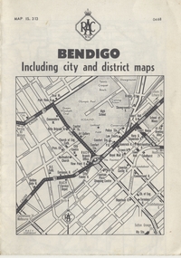
Map, Royal Automobile Club of Victoria, "Bendigo Including city and district maps - RACV", c1968
Printed street map titled "Bendigo Including city and district maps", published by the RACV, showing the central part of Bendigo on the front cover, Bendigo Outlets and notes on the city itself. Has the tram lines shown dotted, only shows the full extent of the Golden Square line. Inside has a district road map. The front cover has the number "0468" in the bottom left hand corner, indicating the publication date.in ink on the Bendigo Outlet map, has various notes showing the location of crossing loops on and off the map and the location of the tram depot itself.trams, tramways, map, bendigo, racv, railways -
 Bayside Gallery - Bayside City Council Art & Heritage Collection
Photograph, Department of Crown Lands and Survey, Victoria, Brighton, Elwood and Elsternwick, c. 1965-71
The Department of Crown Lands and Survey (1857-1983) was responsible for the administration of survey and mapping and the sale, occupation and management of crown land throughout its existence. This aerial photograph shows parts of Brighton, Elwood and Elsternwick and was taken circa 1965-71.brighton, department of crown lands and survey, aerial photograph, bayside, port phillip bay, map, cartographic material, elwood, elsternwick, elsternwick park, elwood tram depot, elwood pier, new street, glen huntly road, st kilda street, nepean highway -
 Bendigo Historical Society Inc.
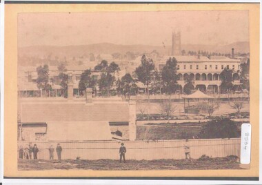
Photograph - Pall Mall shops
BHS CollectionA4 copy of original photograph. Pall Mall shops viewed from Government Camp, prior to 1870 (when Post Office and Court House were erected). View shows the Shamrock Hotel and the Royal Exchange Hotel with linked verandahs, the bell tower of St Paul's Anglican Church; and band stand (on the site of Post Office) beyond the creek. In the foreground part of the Government Offices with eight men shown on fence line.bendigo buildings, early buildings in bendigo late 1800s -
 University of Melbourne, Burnley Campus Archives
Plan, A. Lucy, Burnley Gardens Site Works, 1958
Plan showing layout of Gardens bound by Swan St and the Yarra Boulevard. Buildings shown include Fernery, Silo, Residence, Glasshouses, Manure Bins, Store, Milking Sheds, Admin. Building, Laying Sheds, Breeder Shed, Chicken Run, Potting Shed and Plant Research Lab. Also showing proposed paths and kerbing. Public Works Dept., Chief Engineer's Dept. drawn by A. Lucy. Scale 1 in:40 ftgardens, sheds, glasshouses, buildings, a. lucy -
 Bendigo Historical Society Inc.
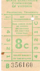
Memorabilia - PROVINCIAL TRAMWAYS TICKET
BHS CollectionA Collection of Provincial Tramways Ticket: Cream paper with green print value 8c.. State Electricity Commission of Victoria Provincial Tramways. 20 Tickets all with a hole punched in the *in* section. Not Transferable. This check must be shown on demand or another fare paid. 8c. Issued subject to the By-Laws. Tickets have various numbers of six digits and all starting with 3561.. All with the letter B. On the back is a green checked pattern.government, state, state electricity commission of vic, state electricity commission of victoria provincial tramways. -
 Melbourne Tram Museum
Document - Form/s, Yarra Trams, "Despatch Sheet", 14/10/2006 12:00:00 AM
Partly completed form or report - Despatch Sheet - A4 printed sheet for Friday 14/10/2006? showing Run, driver number, start place, times in and out. kilometres travelled, class of tram, number, track and with remarks. Yarra Trams. Noted that it was found in Z3 142, which is shown on the sheet. On the rear of the sheet is a ink drawing showing lines to Preston Workshops with 142/Z? on the top right hand corner.In pencil "found in pencil" and date filled in with a ? along the top line.trams, tramways, operations, yarra trams, preston workshops -
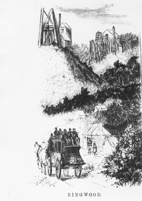 Ringwood and District Historical Society
Photograph, Sketch: Ringwood. An artists impression 1881 or 1891
Typed below photograph of sketch, "Ringwood. An artists impression 1891. Note some of the antimony mines and miners huts shown". Other copy states, "Artist impression of Ringwood, 1881." Written on backing sheet, "Illustrated Australian News, 29/1/1881. p.4. Impressions of Ringwood with miners cottages and poppet heads." -
 Phillip Island and District Historical Society Inc.
Photograph, Churchill Island cannon, 1973
This cannon was always called the Shenandoah cannon as it was believed to be from the Confederate warship, Shenandoah. However recent research has shown this was not true. In 1981 the American Civil War Round Table of Australia claimed the cannon was not government issue.It was older than the Shenandoah warship.It is possibly a 4 lb that was sent from Sydney in 1826 when Western Port was settled and had been left behind.Historical3 small coloured photographs mounted on cardboard of Churchill Island homestead, 2 men standing beside the cannon and the cannon.Churchill Island homestead, Shenandoah cannon, S.J.McFee, F. Jansson, Shenandoah cannon. 1973churchill island, churchill island - homestead, cannon, stan mcfee, frank jansson -
 Eltham District Historical Society Inc
Slide - Photograph, Unidentified location, Eltham district, c.Aug. 1990
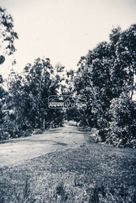
Part of a presentation, "Roads and Byways of the Shire of Eltham", by Russell Yeoman to the 12 September 1990 Society meeting. Slides shown included copies of old photos and recent images ranging from the suburban streets of Eltham and Montmorency to the mountain roads of Kinglake. In the byways category are views of some iof the Shire's bicycle paths including then recently completed sections of the Main Yarra Trail at Lower Plenty.35mm colour positive transparency (1 of 37) Mount - Agfachrome Agfa CS System black 8 dotseltham, infrastructure, roads, unidentified -
 Eltham District Historical Society Inc
Slide - Photograph, Unidentified location, Eltham district, c.Aug. 1990
Part of a presentation, "Roads and Byways of the Shire of Eltham", by Russell Yeoman to the 12 September 1990 Society meeting. Slides shown included copies of old photos and recent images ranging from the suburban streets of Eltham and Montmorency to the mountain roads of Kinglake. In the byways category are views of some iof the Shire's bicycle paths including then recently completed sections of the Main Yarra Trail at Lower Plenty.35mm colour positive transparency (1 of 37) Mount - Agfachrome Agfa CS System black 8 dotseltham, infrastructure, roads, unidentified -
 Eltham District Historical Society Inc
Slide - Photograph, Near the old Lower Plenty Bridge (present day Edward Willis Court), c.Aug. 1990
Part of a presentation, "Roads and Byways of the Shire of Eltham", by Russell Yeoman to the 12 September 1990 Society meeting. Slides shown included copies of old photos and recent images ranging from the suburban streets of Eltham and Montmorency to the mountain roads of Kinglake. In the byways category are views of some iof the Shire's bicycle paths including then recently completed sections of the Main Yarra Trail at Lower Plenty.35mm colour positive transparency (1 of 37) Mount - Agfachrome Agfa CS System black 8 dotsinfrastructure, roads, edward willis court, lower plenty, lower plenty bridge -
 Eltham District Historical Society Inc
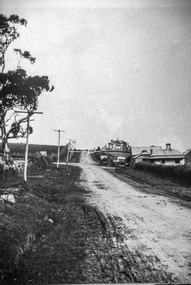
Slide - Photograph, Main Road, Eltham, c.1910, c.Aug. 1990
Part of a presentation, "Roads and Byways of the Shire of Eltham", by Russell Yeoman to the 12 September 1990 Society meeting. Slides shown included copies of old photos and recent images ranging from the suburban streets of Eltham and Montmorency to the mountain roads of Kinglake. In the byways category are views of some iof the Shire's bicycle paths including then recently completed sections of the Main Yarra Trail at Lower Plenty.35mm colour positive transparency (1 of 37) Mount - Agfachrome Agfa CS System black 8 dotsinfrastructure, roads, main road, eltham -
 Eltham District Historical Society Inc
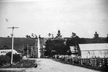
Slide - Photograph, Eltham-Yarra Glen Road, Kangaroo Ground c.1910, c.Aug. 1990
Part of a presentation, "Roads and Byways of the Shire of Eltham", by Russell Yeoman to the 12 September 1990 Society meeting. Slides shown included copies of old photos and recent images ranging from the suburban streets of Eltham and Montmorency to the mountain roads of Kinglake. In the byways category are views of some iof the Shire's bicycle paths including then recently completed sections of the Main Yarra Trail at Lower Plenty.35mm colour positive transparency (1 of 37) Mount - Agfachrome Agfa CS System black 8 dotsinfrastructure, roads, eltham-yarra glen road, kangaroo ground -
 Eltham District Historical Society Inc
Slide - Photograph, Unidentified location, Eltham district, c.Aug. 1990
Part of a presentation, "Roads and Byways of the Shire of Eltham", by Russell Yeoman to the 12 September 1990 Society meeting. Slides shown included copies of old photos and recent images ranging from the suburban streets of Eltham and Montmorency to the mountain roads of Kinglake. In the byways category are views of some iof the Shire's bicycle paths including then recently completed sections of the Main Yarra Trail at Lower Plenty.35mm colour positive transparency (1 of 37) Mount - Agfachrome Agfa CS System black 8 dotsinfrastructure, roads, houses, private street scheme, residential, unidentified -
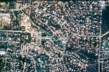
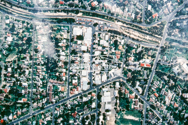
 Eltham District Historical Society Inc
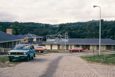
Slide - Photograph, Aerial Photo (c.1987): Main Road, Eltham from Pitt Street to Elsa Court, c.Aug. 1990
Part of a presentation, "Roads and Byways of the Shire of Eltham", by Russell Yeoman to the 12 September 1990 Society meeting. Slides shown included copies of old photos and recent images ranging from the suburban streets of Eltham and Montmorency to the mountain roads of Kinglake. In the byways category are views of some iof the Shire's bicycle paths including then recently completed sections of the Main Yarra Trail at Lower Plenty.35mm colour positive transparency (1 of 37) Mount - Agfachrome Agfa CS System black 8 dotsinfrastructure, roads, aerial photographs, alistair knox park, bridge street, central park, diamond street, elsa court, eltham, eltham common, eltham railway station, eltham town park, main road, pitt street -
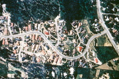
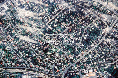
 Eltham District Historical Society Inc
Slide - Photograph, Aerial Photo (c.1987): Woodridge Estate, Eltham, c.Aug. 1990
Part of a presentation, "Roads and Byways of the Shire of Eltham", by Russell Yeoman to the 12 September 1990 Society meeting. Slides shown included copies of old photos and recent images ranging from the suburban streets of Eltham and Montmorency to the mountain roads of Kinglake. In the byways category are views of some iof the Shire's bicycle paths including then recently completed sections of the Main Yarra Trail at Lower Plenty.35mm colour positive transparency (1 of 37) Mount - Agfachrome Agfa CS System black 8 dotsinfrastructure, roads, aerial photographs, eltham, housing estate, woodridge estate -
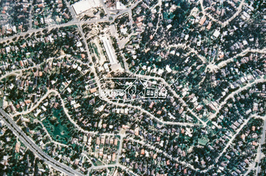
 Eltham District Historical Society Inc
Slide - Photograph, Aerial Photo (c.1987): Main Road and Leanne Drive, Eltham, c.Aug. 1990
Part of a presentation, "Roads and Byways of the Shire of Eltham", by Russell Yeoman to the 12 September 1990 Society meeting. Slides shown included copies of old photos and recent images ranging from the suburban streets of Eltham and Montmorency to the mountain roads of Kinglake. In the byways category are views of some iof the Shire's bicycle paths including then recently completed sections of the Main Yarra Trail at Lower Plenty.35mm colour positive transparency (1 of 37) Mount - Agfachrome Agfa CS System black 8 dotsinfrastructure, roads, aerial photographs, eltham, leanne drive, main road -
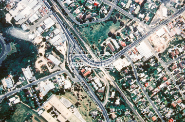
 Eltham District Historical Society Inc
Slide - Photograph, Aerial Photo (c.1987): Main Road, Fitzsimons Lane, Lower Plenty, c.Aug. 1990
Part of a presentation, "Roads and Byways of the Shire of Eltham", by Russell Yeoman to the 12 September 1990 Society meeting. Slides shown included copies of old photos and recent images ranging from the suburban streets of Eltham and Montmorency to the mountain roads of Kinglake. In the byways category are views of some iof the Shire's bicycle paths including then recently completed sections of the Main Yarra Trail at Lower Plenty.35mm colour positive transparency (1 of 37) Mount - Agfachrome Agfa CS System black 8 dotsinfrastructure, roads, aerial photographs, roundabout, bolton steet, bolton steet shops, eltham, fitzsimons lane, lower plenty, main road -
 Eltham District Historical Society Inc
Slide - Photograph, Aerial Photo (c.1987): Montmorency South Primary School, Grand Boulevard and Main Road, c.Aug. 1990
Part of a presentation, "Roads and Byways of the Shire of Eltham", by Russell Yeoman to the 12 September 1990 Society meeting. Slides shown included copies of old photos and recent images ranging from the suburban streets of Eltham and Montmorency to the mountain roads of Kinglake. In the byways category are views of some iof the Shire's bicycle paths including then recently completed sections of the Main Yarra Trail at Lower Plenty.35mm colour positive transparency (1 of 37) Mount - Agfachrome Agfa CS System black 8 dotsinfrastructure, roads, aerial photographs, main road, montmorency, montmorency south primary school, grand boulevard -
 Eltham District Historical Society Inc
Slide - Photograph, Aerial Photo (c.1987): Main Road, Lower Plenty from Heidelberg Golf Course to Plenty River, c.Aug. 1990
Part of a presentation, "Roads and Byways of the Shire of Eltham", by Russell Yeoman to the 12 September 1990 Society meeting. Slides shown included copies of old photos and recent images ranging from the suburban streets of Eltham and Montmorency to the mountain roads of Kinglake. In the byways category are views of some iof the Shire's bicycle paths including then recently completed sections of the Main Yarra Trail at Lower Plenty.35mm colour positive transparency (1 of 37) Mount - Agfachrome Agfa CS System black 8 dotsinfrastructure, roads, aerial photographs, heidelberg golf club, lower plenty, lower plenty bridge, main road, plenty river -
 Eltham District Historical Society Inc
Slide - Photograph, Aerial Photo (c.1987): Sherbourne Road overpass, Briar Hill, c.Aug. 1990
Part of a presentation, "Roads and Byways of the Shire of Eltham", by Russell Yeoman to the 12 September 1990 Society meeting. Slides shown included copies of old photos and recent images ranging from the suburban streets of Eltham and Montmorency to the mountain roads of Kinglake. In the byways category are views of some iof the Shire's bicycle paths including then recently completed sections of the Main Yarra Trail at Lower Plenty.35mm colour positive transparency (1 of 37) Mount - Agfachrome Agfa CS System black 8 dotsinfrastructure, roads, aerial photographs, briar hill, overpass, para road, railway bridge, sherbourne road -
 Eltham District Historical Society Inc
Slide - Photograph, Aerial Photo (c.1987): Were Street, Montmorency, c.Aug. 1990
Part of a presentation, "Roads and Byways of the Shire of Eltham", by Russell Yeoman to the 12 September 1990 Society meeting. Slides shown included copies of old photos and recent images ranging from the suburban streets of Eltham and Montmorency to the mountain roads of Kinglake. In the byways category are views of some iof the Shire's bicycle paths including then recently completed sections of the Main Yarra Trail at Lower Plenty.35mm colour positive transparency (1 of 37) Mount - Agfachrome Agfa CS System black 8 dotsinfrastructure, roads, aerial photographs, montmorency, were street -
 Eltham District Historical Society Inc
Slide - Photograph, Aerial Photo (c.1987): Montmorency, north of railway, c.Aug. 1990
Part of a presentation, "Roads and Byways of the Shire of Eltham", by Russell Yeoman to the 12 September 1990 Society meeting. Slides shown included copies of old photos and recent images ranging from the suburban streets of Eltham and Montmorency to the mountain roads of Kinglake. In the byways category are views of some iof the Shire's bicycle paths including then recently completed sections of the Main Yarra Trail at Lower Plenty.35mm colour positive transparency (1 of 37) Mount - Agfachrome Agfa CS System black 8 dotsinfrastructure, roads, aerial photographs, montmorency -
 Eltham District Historical Society Inc
Slide - Photograph, Army Map, Yan Yean (Part, 1934), c.Aug. 1990
Part of a presentation, "Roads and Byways of the Shire of Eltham", by Russell Yeoman to the 12 September 1990 Society meeting. Slides shown included copies of old photos and recent images ranging from the suburban streets of Eltham and Montmorency to the mountain roads of Kinglake. In the byways category are views of some iof the Shire's bicycle paths including then recently completed sections of the Main Yarra Trail at Lower Plenty.35mm colour positive transparency (1 of 37) Mount - Agfachrome Agfa CS System black 8 dotsinfrastructure, roads, map, shire of eltham -
 Eltham District Historical Society Inc
Slide - Photograph, Shalbury Avenue, Eltham, c.Aug. 1990
Part of a presentation, "Roads and Byways of the Shire of Eltham", by Russell Yeoman to the 12 September 1990 Society meeting. Slides shown included copies of old photos and recent images ranging from the suburban streets of Eltham and Montmorency to the mountain roads of Kinglake. In the byways category are views of some iof the Shire's bicycle paths including then recently completed sections of the Main Yarra Trail at Lower Plenty.35mm colour positive transparency (1 of 37) Mount - Agfachrome Agfa CS System black 8 dotseltham, infrastructure, shalbury avenue -
 Eltham District Historical Society Inc
Slide - Photograph, Main Yarra Trail, Lower Plenty, c.Aug. 1990
Part of a presentation, "Roads and Byways of the Shire of Eltham", by Russell Yeoman to the 12 September 1990 Society meeting. Slides shown included copies of old photos and recent images ranging from the suburban streets of Eltham and Montmorency to the mountain roads of Kinglake. In the byways category are views of some iof the Shire's bicycle paths including then recently completed sections of the Main Yarra Trail at Lower Plenty.35mm colour positive transparency (1 of 37) Mount - Agfachrome Agfa CS System black 8 dotsinfrastructure, bonds road, lower plenty, main yarra trail, roads, significant trees -
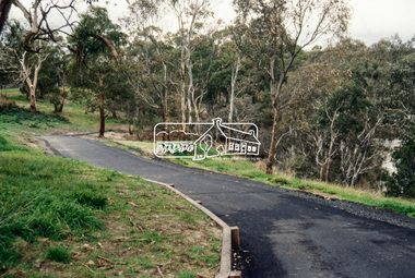 Eltham District Historical Society Inc
Slide - Photograph, Main Yarra Trail, Lower Plenty, c.Aug. 1990
Part of a presentation, "Roads and Byways of the Shire of Eltham", by Russell Yeoman to the 12 September 1990 Society meeting. Slides shown included copies of old photos and recent images ranging from the suburban streets of Eltham and Montmorency to the mountain roads of Kinglake. In the byways category are views of some iof the Shire's bicycle paths including then recently completed sections of the Main Yarra Trail at Lower Plenty.35mm colour positive transparency (1 of 37) Mount - Agfachrome Agfa CS System black 8 dotsinfrastructure, bonds road, lower plenty, main yarra trail, roads, yarra river -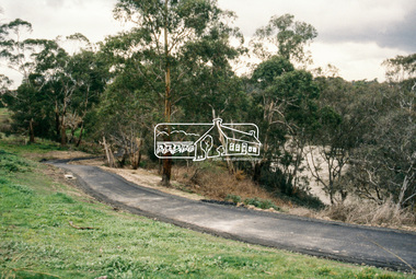
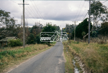 Eltham District Historical Society Inc
Slide - Photograph, Main Yarra Trail, Lower Plenty, c.Aug. 1990
Part of a presentation, "Roads and Byways of the Shire of Eltham", by Russell Yeoman to the 12 September 1990 Society meeting. Slides shown included copies of old photos and recent images ranging from the suburban streets of Eltham and Montmorency to the mountain roads of Kinglake. In the byways category are views of some iof the Shire's bicycle paths including then recently completed sections of the Main Yarra Trail at Lower Plenty.35mm colour positive transparency (1 of 37) Mount - Agfachrome Agfa CS System black 8 dotsinfrastructure, bonds road, lower plenty, roads