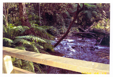
Showing 16825 items
matching snowy-river-bridge-1976
-
 Phillip Island and District Historical Society Inc.
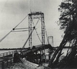
Photograph, Suspension Bridge, 1939-40
Phillip Island Suspension Bridge under construction - completed in 1940Phillip Island Suspension Bridge taken from shore on angle - Phillip Island side - trees pushed onto right hand side.local history, photographs, civil engineering, bridges, phillip island suspension bridge, black & white photograph, jack jenner collection, phillip island bridges -
 The Beechworth Burke Museum
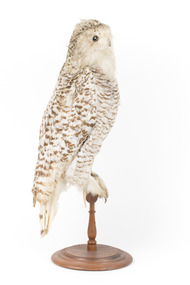
Animal specimen - Snowy Owl, Trustees of the Australian Museum, 1860- 1880
The Snowy owl is a large and powerful bird. It is one of the largest species of owl, and in North America, it is on average the heaviest owl species. The adult male is virtually pure white, but females and young birds have some dark spots; the young are heavily barred, and dark spotting may even predominate. Thick plumage, heavily feathered taloned feet, and coloration render the Snowy owl well-adapted for life north of the Arctic Circle. This Snowy Owl example is slightly discoloured and in real life the Snowy Owl displays much more brilliant white feathers. This specimen is part of a collection of almost 200 animal specimens that were originally acquired as skins from various institutions across Australia, including the Australian Museum in Sydney and the National Museum of Victoria (known as Museums Victoria since 1983), as well as individuals such as amateur anthropologist Reynell Eveleigh Johns between 1860-1880. These skins were then mounted by members of the Burke Museum Committee and put-on display in the formal space of the Museum’s original exhibition hall where they continue to be on display. This display of taxidermy mounts initially served to instruct visitors to the Burke Museum of the natural world around them, today it serves as an insight into the collecting habits of the 19th century.This specimen is part of a significant and rare taxidermy mount collection in the Burke Museum. This collection is scientifically and culturally important for reminding us of how science continues to shape our understanding of the modern world. They demonstrate a capacity to hold evidence of how Australia’s fauna history existed in the past and are potentially important for future environmental research. This collection continues to be on display in the Museum and has become a key part to interpreting the collecting habits of the 19th century.This Snowy Owl adult male is virtually pure white with brown spot markings and a pale brownish wash. It has thick plumage and heavily feathered taloned feet. This specimen stands upon a wooden platform and has an identification tag tied around its leg.Swing tag: [torn] snowy owl / See catalogue, page 54 / Metal tag: 4054 /taxidermy mount, taxidermy, animalia, burke museum, beechworth, australian museum, skin, reynell eveleigh johns, bird, owl, snowy owl, arctic circle -
 Charlton Golden Grains Museum Inc
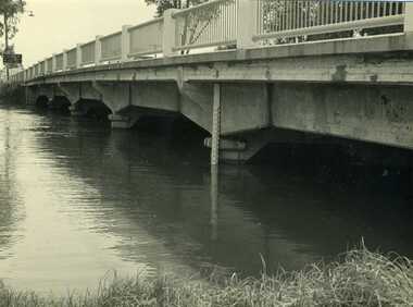
Photograph, Ian Cameron, 1973 February Flood, Feb 1973
1973 flood. High water depth under Paterson Bridge, Charlton Victoria,B/W photograph of 1973 flood. High water depth under Paterson Bridge.flood, james paterson bridge, charlton -
 Phillip Island and District Historical Society Inc.
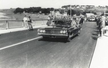
Photograph, Phillip Island Bridge Opening, 1969
First traffic across 2nd Bridge, 1969, between Sand Remo & Newhaven, after official opening ceremony. From the Jack Jenner Collection.Minister's Car driving across newly opened Bridge between San Remo & Phillip Island 1969.local history, photographs, civil engineering, bridges, opening of phillip island bridge, black & white photograph, jack jenner collection, phillip island bridges, public construction -
 Clunes Museum
Photograph
PHOTOGRAPH TAKEN LOOKING DOWNSTREAM TULLAROOP CREEK, ABOUT 1900. GOVERNMENT BRIDGE IN FOREGROUND, JULILEE BRIDGE IN MIDDLE DISTANCE, PORT PHILLIP MINE POPPET HED IN DISTANCE..1 ORIGINAL PHOTOGRAPH OF GOVERNMENT BRIDGE AND JUBILEE BRIDGE. TAKEN FROM CREEK PARADE. THE GOVERNMENT BRIDGE WAS BUILT CIRCA 1900. .2 ENLARGED PHOTOCOPY IN HANDWRITING : LOOKING DOWN-STREAM TULLAROOP CREEKABOUT 1900 GOVERMENT BRIDGE IN FOREGROUND JUBILEE BRIDGE IN THE MIDDLEbridges, jubilee bridge, goverment bridge -
 Greensborough Historical Society
Photograph - Digital Image, Marilyn Smith, Plenty River at the aqueduct crossing Greensborough 2019, 02/07/2019
The Plenty River at the aqueduct crossing, 2019, showing graffiti on the river bank rocks. Originally part of the Maroondah Aqueduct pipeline, all that remains is the bridge that once carried the pipe over the Plenty River. This photograph was taken from the Plenty River Trail in Greensborough. 2 colour digital photographsplenty river trail, maroondah pipetrack, maroondah aqueduct, plenty river, graffiti -
 Marysville & District Historical Society
Photograph (Item) - Black and white photograph, Bridge Over The Cumberland, c1900
An early black and white photograph of a bridge over the Cumberland Creek near Marysville in Victoria.An early black and white photograph of a bridge over the Cumberland Creek near Marysville in Victoria. The Cumberland Creek is in the Cumberland Valley near Cambarville which was a timber town near Marysville. Cambarville is notable for its giant mountain ash (Eucalyptus regnans) trees within the Cumberland Memorial Scenic Reserve, and relics from former sawmills and gold mining. The Big Culvert is located nearby on the Marysville - Woods Point Road, which was historically part of the Yarra Track. Cambarville was established as a timber mill town in the 1940s. Timber mill owners A Cameron and FJ Barton named Cambarville. They established the mill to salvage timber from trees destroyed in the 1939 bushfires. Cambarville was impacted by the 2009 Black Saturday bushfires and any remaining structures were destroyed.ARMSTRONG COLLECTION 42 STATION STREET/ SANDRINGHAM 3191/ TEL. (03) 9521 5442/ IAN M.L. ARMSTRONG OAMcumberland creek, marysville, victoria, cumberland valley, cambarville, mountain ash, eucalyptus regnans, cumberland memorial reserve, the big culvert, marysville-wood's point road, yarra track, a cameron, fj barton, 2009 black saturday bushfires -
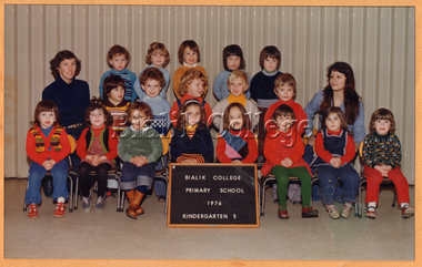 Bialik College
Photograph, Kindergarten 5, 1976, 1976
Kindergarten 5, 1976. Please contact [email protected] to request access to this record.shakespeare grove, kindergarten, elc, early learning centre, class photograph, 1970s -
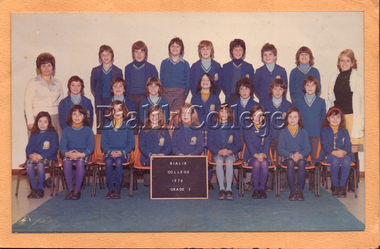 Bialik College
Photograph, Grade 3, 1976, 1976
Grade 3, 1976. Please contact [email protected] to request access to this record.1970s, class photograph -
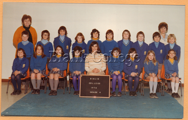 Bialik College
Photograph, Grade 4, 1976, 1976
Grade 4, 1976. Please contact [email protected] to request access to this record.1970s -
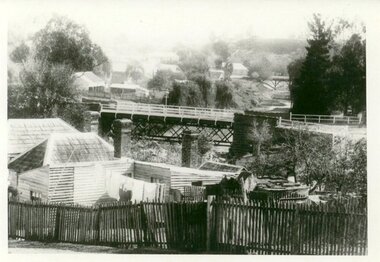
 Lakes Entrance Regional Historical Society (operating as Lakes Entrance History Centre & Museum)
Photograph, 1/12/2027 12:00:00 AM
Also a black and white photograph 10 x 15 of same 04470.1 donated by Marion Holding 21 November 2013Sepia toned photograph of a lifter bridge over the Tambo River built as a temporary crossing after the collapse of the original draw Bridge in 1925 at Swan Reach VictoriaTambo River Christmas 1927 on reversereligion, buildings -
 Warrnambool and District Historical Society Inc.
Map - An Angler's map of the Hopkins River Estuary, Angler's map Hopkins River, 1980s
This is a map of the Hopkins River Estuary prepared by Dr John Sherwood for the benefit of anglers. The information on the sheet includes the location of sand banks, the water depths, boat ramp facilities and public access facilities. Some of the information has been gathered from aerial photographs. The map has been produced by the Warrnambool Institute of Advanced Education which was developed in the late 1960s from the tertiary section of the Warrnambool Technical College and with all its departments established by 1984 at the Sherwood Campus five kilometres from Warrnambool on the Princes Highway. Today the site is occupied by Deakin University, Warrnambool campus. The Warrnambool Anglers’ Club has its headquarters on the banks of the Hopkins River near the mouth of the river and the Lyndoch Aged Care facility.This map is of interest as a specialist one, providing fishermen with detailed information on all aspects of the Hopkins river estuary. Fishing has been both a profession and a popular recreational pursuit for Warrnambool residents since the early days of the city’s settlement. The Hopkins River Estuary has been a focal point for fishermen throughout Warrnambool’s history. This is a sheet of paper folded three times to produce a folded map. The front cover has a black and white photograph of two fishermen with a large fish. The map of the Hopkins River Estuary is in yellow, blue and black and covers the side of one sheet and three quarters of the other side. There is an advertisement for the Hopkins River Boathouse with a black and white sketch of the boathouse and notes on the map written by Dr John Sherwood. There are several diagrams showing the water depths. The map has some silverfish damage and some tearing at the folds. warrnambool anglers’ club, history of warrnambool, hopkins river, hopkins river estuary, john sherwood -
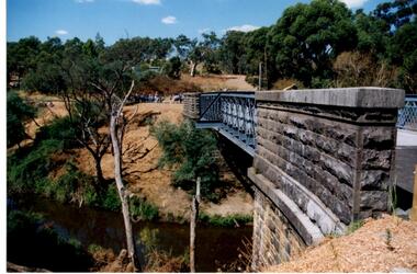
 Greensborough Historical Society
Report, Examining Draughtsman's Report - Watts River Aqueduct, 20/07/1897
This Field Survey was commissioned by the Melbourne Board of Works and was used to position the Maroondah Aqueduct bridge north of Greensborough at its crossing point on the Plenty River. It incorporated the use of wrought iron water pipes and therefore is of lighter construction than other similar bridges in the district. It features a traverse of the Plenty RiverThe Maroondah Aqueduct bridge is a significant example of late 19th century engineering. A 4 page reproduction of an Office of Titles document. Copy of handwritten report includes maps.maroondah aqueduct, watts river aqueduct, bridge, greensborough, office of titles, 1897, wrought iron water pipes, plenty river, melbourne board of works -
 Marysville & District Historical Society
Postcard (item) - Colour postcard, Nicholas John Caire, Scene Watt's River, Fernshaw, 1858-1918
One of a series of postcards of photographs taken by socialite photographer Nicholas John Caire. N.J. Caire had a great love for the area and in the late 1800's took many photographs of Marysville and its surrounds.One of a series of postcards of photographs taken by socialite photographer Nicholas John Caire. N.J. Caire had a great love for the area in and surrounding Marysville and in the late 1800's took many photographs of Marysville and its surrounds. N.J. Caire was born in 1837 in Guernsey. He arrived in Adelaide about 1860 along with his parents who encouraged his early interest in photography. He opened a studio in Adelaide in 1867 after traveling extensively throughout the Gippsland taking photographs. After marrying in 1870 he moved to Talbot in Victoria until 1876 when he opened a studio in the Royal Arcade in Melbourne. After 1885 N.J. Caire gave up his city work and made his home in South Yarra and devoted the rest of his life to outdoor photography, specializing in the bush, the gullies and the mountains of south-eastern Victoria. POST CARD This Space may be used for Correspondence (FOR ADDRESS ONLY) Orange one penny postage stamp with an image depicting Queen Victoria Date stamp/ 8.3.06/ 4AM/ MELBOURNE/ 14 7.3.06 My Dear Em/ I received your kind/ note and will be very pleased/ to go out & see you tomorrow/ but cannot say what/ train I will catch as/ I do not know how/ they run. I will try/ not to miss the train/ though. I heard Vic was/ down will be glad to see/ her love to you both/ Yours in health Mary. Mrs Tribeau/ "Hazel Dell"/ Connell Street/ Hawthornwatt's river, fernshaw, victoria, nicholas john caire, postcard, souvenir -
 Stawell Historical Society Inc
Book, P. Van Diesen, Tobacco Growing in Dadswells Bridge, 1991
History Option H.3.C. Tobacco Industry at Dadwells Bridge Contains various photographs.Clear Plastic cover with dark blue edge. on Plastic History Option P. Van Diesen. On Paper underneath cover Tobacco Growing in Dadswell Bridgestawell farming -
 Phillip Island and District Historical Society Inc.
Photograph, Phillip Island Bridge Opening, 1969
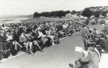
Official Opening of 2nd San Remo - Newhaven Bridge, 1969 by Hon. Porter, Minister of Public Works. From the Jack Jenner Collection.Large crowd, some seated, on road approach to New Bridge San Remo side, on day of Opening 1969.local history, photographs, civil engineering, bridges, phillip island bridge, black & white photograph, jack jenner collection, phillip island bridges, public construction -
 Eltham District Historical Society Inc
Photograph, Oxley Bridge construction, Henley Road, Kangaroo Ground, 1962, 1962
This is copy of a photograph taken 1962, during the construction of Oxley Bridge at Kangaroo GroundBlack and white photograph of Oxley Bridge construction over Watsons Creek, Henley Road, Kangaroo Ground, circa Aug-Sep 1962kangaroo ground, oxley bridge, watsons creek, henley road, bridges -
 Greensborough Historical Society
Photograph - Digital Image, Anne Paul, Opening of restored Old Lower Plenty Bridge 2001 - side view of bridge, 14/03/2001
The opening of the restored Old Lower Plenty Bridge, opened on 14/03/2001 by the Minister for Environment and Conservation Sherryl Garbutt MLA and Mayor of Banyule Cr Dale Peters. The project was jointly funded by Banyule Council and Parks Victoria. The restored bridge is the oldest remaining bridge in the former Shire of Eltham and forms part of the Plenty River Trail. This photograph shows the bridge from the side elevation, showing the bluestone and iron construction.Digital copy of colour photographlower plenty, lower plenty bridge, sherryl garbutt, dale peters, banyule council, parks victoria -
 Marysville & District Historical Society
Photograph (item) - Colour photograph, 15-05-2008
A colour photograph of a wooden bridge crossing over the Taggerty River.A colour photograph of a wooden bridge crossing over the Taggerty River.2008 05 15taggerty river, wooden bridge -
 Kew Historical Society Inc
Administrative record - Documents, Auburn Heights Men's Bowling Club Minutes of Meetings 1976-77, 1976-1977
Sports Clubs in Kew in the final decades of the 19th century and in the early 20th century were often umbrella organisations with facilities for a number of sports. Typically in Kew, this included teams in lawn bowls, tennis and croquet. The Kew Bowling Club was formed in 1880 while the privately owned Auburn Heights Recreation Club was opened in 1904. By 1998, the two Clubs decided to amalgamate at the Auburn Heights site in Barkers Road, forming the Kew Heights Sports Club. The combined club was itself taken over by the Melbourne Cricket Club in 2012 becoming MCC Kew Sports Club. In 2017 MCC Kew closed and its landholding was subsequently sold to Carey Baptist Grammar School. Both the Kew and Auburn Heights Clubs assembled important collections. These historically significant and large collections were donated to the Society in 2020. The collections include manuscripts, pictures, trophies, plans, honour boards etc. References Barnard FGA 1910, 'Sports and Pastimes' in Jubilee History of Kew Victoria: Its origin & progress 1803-1910. Chapman J & C 1999, The history of the Auburn Heights Recreation Club, 1904 to 1908. Reeve S 2012, City of Boroondara: Thematic Environmental History, p.216.The combined collections of the four sporting clubs making up the collection number hundreds of items that are historically significant locally. They are also significant to the sporting history of the greater Melbourne area and to the sports of lawn bowls and tennis in Australia in the 19th and 20th centuries. The collection illuminates two of the Victorian historic themes - 'Building community life' through forming community organisations and 'Shaping cultural and creative life' by participating in sport and recreation.Unbound minutes of meetings of the Auburn Heights Men's Bowling Club covering the period 1976 to 1977. [The item forms part of the large historic Auburn Heights Recreation Club collection, with items relating to the sports of lawn bowls, tennis and croquet, gifted to the Kew Historical Society in 2020].auburn heights men's bowling club - barkers road - kew (vic), auburn heights men's bowling club - minute books -
 Greensborough Historical Society
Photograph - Digital Image, Marilyn Smith, Aqueduct crossing the Plenty River, Greensborough 2019, 02/07/2019
The aqueduct crossing the Plenty River, 2019, overgrown with vegetation. Originally part of the Maroondah Aqueduct pipeline, all that remains is the bridge that once carried the pipe over the Plenty River. This photograph was taken from the Plenty River Trail in Greensborough. 3 colour digital photographsplenty river trail, maroondah pipetrack, maroondah aqueduct, plenty river, graffiti -
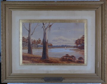 Glenelg Shire Council Cultural Collection
Painting, Scene on the River Murray, n.d
Art Collection Previously located in History HouseThe painting depicts a body of water with two large trees in the foreground. The two trees are situated on the left side of the riverbank which extends across the foreground of the work. The trees extend beyond the borders of the work with only a few branches visible at the top of the work. To the right of the trees, on the surfaceof the water, is a boat with a large white sail. The river bed continues on the left and right sides of the work and is covered with brown trees. The background features a distant view of the riverbank covered in blue trees. The work has a gilded ornate frame with cardboard and gilded mount and glass.Front: A.S. Murray plaque attached to frame: SCENE on the RIVER MURRAY Back: W. HAMER __________Street, Ballarat -
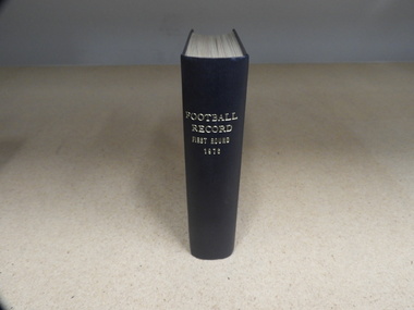 Carlton Football Club
Hardcover Book, Football Record - First Round - 1976 - Carlton, 1976
Hardcover book made in 1976 made to keep original copies of “The Football Record”. This book contains all Football Records relating to Carlton games for the home and away season of 1976. Captain: Alex Jesaulenko Coach: Ian Thorogood Leading Goal-kicker: Robert Walls - 55 goals Best & Fairest: Trevor KeoghHardcover book, navy blue -
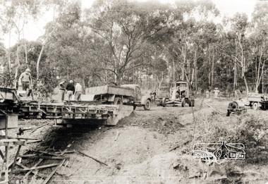
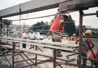
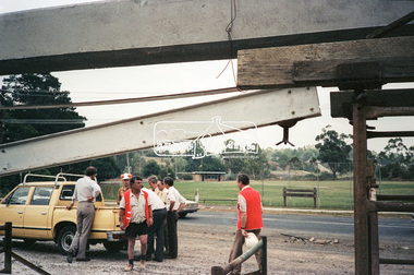
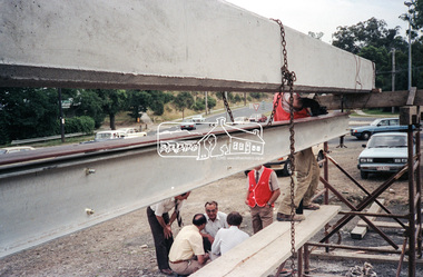
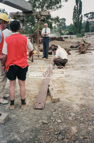 Eltham District Historical Society Inc
Negative - Photograph, Construction work, Main Street Bridge, Greensborough, c.Dec. 1983
The original bridge over the Plenty River was replaced by a single lane bridge each way fed by two lanes each way on either side. As traffic grew a second bridge was added to complete the divided road across the riverFilm - Kodak CM 400 5079 7 strips, 26 framesinfrastructure, roads, bridge construction, greensborough, main street bridge, road construction -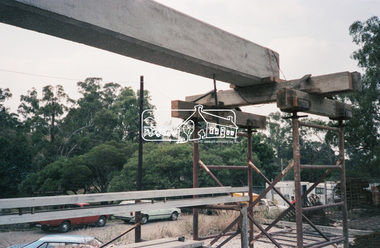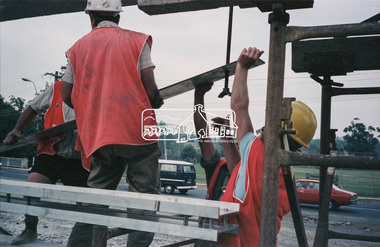
 Eltham District Historical Society Inc
Negative - Photograph, Construction work, Main Street Bridge, Greensborough, c.Aug. 1978
The original bridge over the Plenty River was replaced by a single lane bridge each way fed by two lanes each way on either side. As traffic grew a second bridge was added to complete the divided road across the riverFilm - Kodak CM 400 5079 7 strips, 26 framesinfrastructure, roads, bridge construction, greensborough, main street bridge, road construction -
 Eltham District Historical Society Inc
Negative - Photograph, Construction work, Main Street Bridge, Greensborough, c.Dec. 1983
The original bridge over the Plenty River was replaced by a single lane bridge each way fed by two lanes each way on either side. As traffic grew a second bridge was added to complete the divided road across the riverFilm - Kodak CM 400 5079 7 strips, 26 framesinfrastructure, roads, bridge construction, greensborough, main street bridge, road construction -
 Eltham District Historical Society Inc
Negative - Photograph, Construction work, Main Street Bridge, Greensborough, c.Dec. 1983
The original bridge over the Plenty River was replaced by a single lane bridge each way fed by two lanes each way on either side. As traffic grew a second bridge was added to complete the divided road across the riverFilm - Kodak CM 400 5079 7 strips, 26 framesinfrastructure, roads, bridge construction, greensborough, main street bridge, road construction