Showing 1166 items matching "victoria point"
-
 Lakes Entrance Historical Society
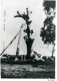
Photograph - Lookout tree, Bulmer H D, 1910 c
Also copy 15 x 10 same imageBlack and white photograph copied from a postcard of the LookOut Tree on Jemmys Point, shows the standing dead grey box tree supported by two heavy logs, a 35 foot ladder attached for access to top. Lakes Entrance Victoria.historic sites, navigation -
 Lakes Entrance Historical Society
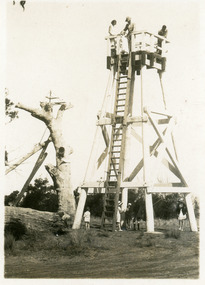
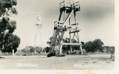
Postcard - Lookout tower Jemmys Point, 1929
... erected on Jemmys Point, Lakes Entrance, Victoria, showing..., 'LookOut Jemmys Point, Lakes Entrance' Small format postcard ...Also, two enlargements, 10 x 15 cm, and one enlargement 17 x 25 cm, all purchasedSmall format postcard showing the first observation lookout erected on Jemmys Point, Lakes Entrance, Victoria, showing a timber structure about 30 feet high with a fenced platform on top, narrow ladder leading straight to top from ground. Five people on ground, three on platform. Old LookOut Tree standing in background.On reverse, 'LookOut Jemmys Point, Lakes Entrance'historic sites, navigation -
 Lakes Entrance Historical Society
Postcard - Lookout tower Jemmy's Point, 1940
... observation lookout at Jemmys Point, Lakes Entrance, Victoria, showing... format postcard of the timber observation lookout at Jemmys Point ...Black and white small format postcard of the timber observation lookout at Jemmys Point, Lakes Entrance, Victoria, showing the updated and safer steps from ground to observation deck, with fenced landing at halfway point. Old log and seat still nearby, signal light on steel tower a short distance away.historic sites, navigation, fences -
 Lakes Entrance Historical Society
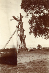
Photograph - Lookout tree, 1910
Black and white small format photograph of the LookOut Tree at Jemmys Point, showing dead tree supported by two logs, a woman two-thirds of the way up the 35 foot ladder which reaches the top. Lakes Entrance, Victoriahistoric sites, navigation -
 Lakes Entrance Historical Society
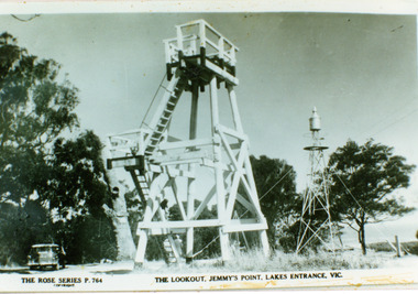
Photograph - Lookout tower Jemmy's Point, The Rose Series, 1950
Identical copy 10 x 15Black and white photograph copied from a postcard showing the timber lookout tower and signal light on Jemmys Point, old lookout tree in background appears to have some of the top missing. Lakes Entrance Victoria.The Lookout Jemmy's Point Lakes Entrancehistoric sites, navigation -
 Lakes Entrance Historical Society
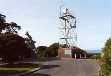
Photograph - Lookout tower Jemmy's Point, Price Wendy, 2008
... on Jemmys Point. Lakes Entrance Victoria.... and steel signal light tow on Jemmys Point. Lakes Entrance Victoria ...This is the after paired photograph used in the 150 year Lakes entrance 1858-2008 display.|The before paired photograph number 02269|Also one 12 x 16 framed photograph used in room display.Colour photograph lookout tree and steel signal light tow on Jemmys Point. Lakes Entrance Victoria.historic sites, navigation -
 Lakes Entrance Historical Society
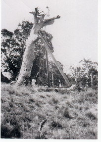
Photograph - Lookout tree, 1927
Black and white photograph of the Lookout Tree on Jemmys Point showing a standing dead grey box tree supported by two long timbers. Access to the top via a 35 foot ladder. Thelma Roder standing on top beside signal structure, two women and child standing near base. Lakes Entrance Victoria,historic sites, navigation -
 Lakes Entrance Historical Society
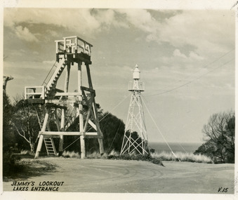
Postcard - Lookout tower Jemmy's Point, Valentine Series, 1940
... observation lookout at Jemmys Point, Lakes Entrance, Victoria, showing... lookout at Jemmys Point, Lakes Entrance, Victoria, showing ...Black and white small format postcard of the timber observation lookout at Jemmys Point, Lakes Entrance, Victoria, showing the timber tower with observation deck, signal light on steel tower nearby. Top of old standing lookout tree just visible.Jemmys Lookout Lakes Entrancehistoric sites, navigation -
 Lakes Entrance Historical Society
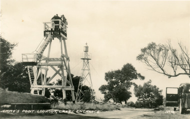
Postcard - Lookout tower Jemmy's Point, Bulmer H D, 1950
Black and white postcard of the timber lookout on Jemmys Point, with the signal light on steel tower nearby. Lakes Entrance Victoria,The Lookout, Lakes Entrancehistoric sites, navigation -
 Lakes Entrance Historical Society
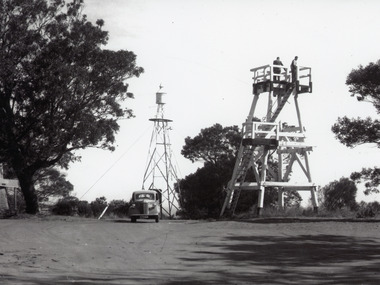
Photograph - Lookout tower Jemmy's Point, 1960
Also one other photograh similar showing steps, landing, and Carpenters Chev car parked.Black and white photograph of the timber lookout on Jemmys Point, steel tower with signal light in background, base of old lookout tree visible on left of image. Lakes Entrance, Victoria.historic sites, navigation -
 Lakes Entrance Historical Society
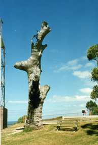
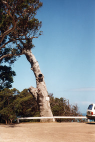
Photograph - Lookout tree, 1990
Colour photograph of the old lookout tree on Jemmys Point, showing a standing dead grey box tree, remains of three branches at top which once held a platform and signal structure. Two timber seats on lawn at base, roadway in foreground. Lakes Entrance, Victoria,2008historic sites, navigation -
 Lakes Entrance Historical Society
Photograph - Lookout tree, 1990
Colour photograph of the old lookout tree on Jemmys Point, showing a standing dead grey box tree, remains of three branches at top which once held a platform and signal structure. Two timber seats on lawn at base, roadway in foreground. Lakes Entrance, Victoria,historic sites, navigation -
 Lakes Entrance Historical Society
Book, Smyth Chris, Baltuiks Isabel, Roberts Lorelle, Roberts Maurice, Stooping Stones a Guide to Mallacoota and District, 1986
Description guide to Mallacoota Victoria and the surrounding district of far East Gippsland including Genoa Gipsy Point and Betka River illustrated with sketch maps photographs and sketches.township -
 Lakes Entrance Historical Society
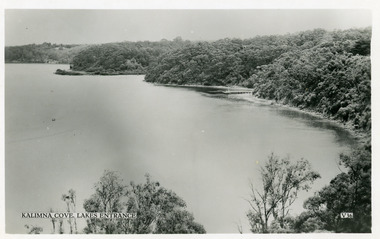
Postcard - Reeve's Channel, Valentine Series, 1940
Black and white postcard taken from elevation on Jemmys Point, showing Reeves Channel, Gippsland Lakes, including Kalimna Jetty and Sawmill Flat at entrance to Maringa Creek, timbered cliffs above lake. Lakes Entrance VictoriaKalimna at Lakes Entrance boats and boating, waterways, topography -
 Victorian Railway History Library
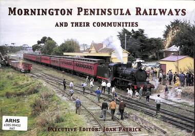
Book, Patrick, Joan, Mornington Peninsula Railway and their communities, 2004
A history of the Mornington Peninsula Railways in Victoria, including to Mornington, Red Hill & Stony Point.ill, maps, p.74.non-fictionA history of the Mornington Peninsula Railways in Victoria, including to Mornington, Red Hill & Stony Point.railroad construction - victoria - history, mornington peninsula - railways - history -
 Bendigo Military Museum
Photograph - Royal Australian Survey Corps - Map Production Processes, c1990
This is a collection of 20 photographs of Royal Australian Survey Corps phases of map production at the School of Military Survey, Bonegilla, the Army Survey Regiment, Bendigo, and the Army Map Depot, Bandiana circa 1990. Colour photos are on 35mm slide film and were scanned at 96 dpi. They are part of the Army Survey Regiment’s Collection. Photo .1P was probably taken on a survey station overlooking Lake Hume near Albury-Wodonga. The field party occupying the survey station was likely from a Map Control Survey course conducted by the School of Military Survey, Bonegilla. This survey station was part of a geodetic network used in field survey training and RASvy’s Lake Hume Test Range. Photos .3P to .16P were taken at the Army Survey Regiment, Bendigo and photos .17P & .18P were taken at the Army Map Depot, Bandiana. Photo .19P depicts a map of RASvy’s ARA units before the disbandment of 5th Field Survey Squadron, Perth and 2nd Field Survey Squadron, Sydney in 1990. This is a collection of 20 photographs of map production processes taken at the School of Military Survey, Bonegilla, the Army Survey Regiment, Bendigo, and the Army Map Depot, Bandiana circa 1990. Colour photos are on 35mm slide film and were scanned at 96 dpi. They are part of the Army Survey Regiment’s Collection. Photo .2P is printed on photographic and scanned at 300 dpi. .1) – Photo, colour, c1980s. Geodetic Surveying: AN/PRR-14 Geoceiver antenna on hill surrounding Lake Hume. Series 3 Land Rover, field party tent and survey station beacon in background. .2) – Photo, black & white, c1980s. Geodetic Surveying: AN/PRR-14 Geoceiver antennas set up at the School of Military Survey, Bonegilla, Victoria. .3) – Photo, colour, c1990. Aerotriangulation: Wild PUG4 point transfer device, SSGT Bruce Hammond. .4) – Photo, colour, c1990. Aerotriangulation: Zeiss (Jena) Stecometer, SSGT Bruce Hammond. .5) – Photo, colour, c1990. Aerotriangulation: computer tape maintenance, SSGT Noel McNamara. .6) – Photo, colour, c1990. AUTOMAP 2: computer tape maintenance, SPR Nadine (Paul) Read. .7) - Photo, colour, c1990s. AUTOMAP 2: Optronics 4040 scanning/film output in Lithographic Squadron, SGT Sherri (Dally) Burke. .8) - Photo, colour, c1990s. AUTOMAP 2: Benson verification plotter output, SPR Nadine (Paul) Read. .9) – Photo, colour, c1990. Aerotriangulation: data management, SGT Neil ‘Ned’ Kelly. .10) & .11) - Photo, colour, c1990s. AUTOMAP 2: Wild B8 Aviograph stereoplotter Feature Extraction, unidentified technician. .12) - Photo, colour, c1990s. AUTOMAP 2: Graphic Edit Workstation, SPR Nadine (Paul) Read. .13) - Photo, colour, c1990s. AUTOMAP 2: Graphic Edit Workstation, SPR Dawn Hoadley. .14) & .15) - Photo, colour, c1990s. AUTOMAP 2: Graphic Edit Workstation, unidentified technician. .16) – Photo, colour, c1990s. Heidelberg Speedmaster 102 computer-controlled five colour lithographic offset printing press. .17) & .18) – Photo, colour, c1990s. Army Map Depot, unidentified storeman, Bandiana. .19) – Photo, colour, c1990. RASvy ARA Unit Locations before disbandment of field units in Perth and Sydney. .20) – Photo, colour, c1990. Set of overlapping aerial photography..1P, .3P to .20P - Some equipment is identified on the frame of the 35mm slides.royal australian survey corps, rasvy, army survey regiment, army svy regt, fortuna, asr, school of military survey, army map depot -
 Hymettus Cottage & Garden Ballarat
Newspaper - MX, There aren't enough hugs to make this pain go away
Marion Taffe was Features Editor for Melbourne's MX commuter newspaper and wrote this feature following the loss of her cousin and family at Kinglake in Victoria's Black Saturday bushfires of 2009. Her article was published in newspapers worldwide.non-fictionMarion Taffe was Features Editor for Melbourne's MX commuter newspaper and wrote this feature following the loss of her cousin and family at Kinglake in Victoria's Black Saturday bushfires of 2009. Her article was published in newspapers worldwide.bushfire, black saturday bushfires, victorian bushfires, kinglake, warnambool, marion taffe, mx, newspaper, davey family -
 Lakes Entrance Historical Society
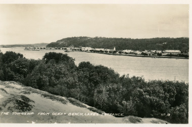
Postcard - Township, 1935c
Black and white small format postcard of town, taken from south shore of the lake. It shows a panoramic view of Esplanade and buildings, jetties, Great War Memorial cypress trees, Jemmys Point and Kalimna Heights in background. Vegetation of sand hummocks in foreground. Lakes Entrance VictoriaThe Township from Ocean Beach Lakes Entrance No 13memorials, vegetation, waterfront, township -
 Lakes Entrance Historical Society
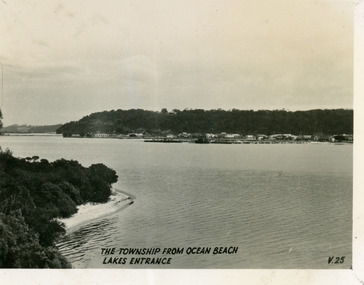
Postcard - Township, 1930c
Black and white small format postcard of the town, taken from the south shore of the lake. It shows a distant view of the town with Jemmys Point and Kalimna Heights in the background, portion of vegetation and south shore beside lake in foreground. Lakes Entrance VictoriaThe Township from Ocean Beach, Lakes Entrance V25vegetation, township, waterfront -
 Lakes Entrance Historical Society
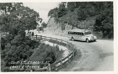
Postcard - Transport, Bulmer H D, 1960c
1 other copyBlack and white postcard of a bend in the Princes Highway at Jemmys Point. It shows two tourist coaches on the road between the steep road cutting and the post and rail fence, gravel footpath on road side of fence. Man directing traffic. Lakes Entrance VictoriaTourist coaches at Lakes Entrance, Victourism, transport, roads and streets -
 Lakes Entrance Historical Society
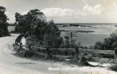
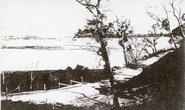
Postcard, Bulmer H D, 1920c
Black and white copy same sizeTinted postcard of a bend in the Princes Highway, Jemmys Point. It shows the road between the steep cutting and post and rail fence. Glimpse of footbridge to Bullock Island, entrance and hummocks. Lakes Entrance VictoriaPrinces Highway, Lakes Entrance topography, waterways, roads and streets -
 Lakes Entrance Historical Society
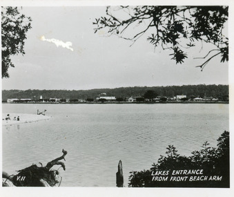
Postcard, 1945c
Black and white small format postcard showing a distant view of the town, taken from the southern shore of the lake. The view shows a glimpse of the beach known formerly as Play Point, the picture framed by native vegetation. Lakes Entrance VictoriaLakes Entrance from front beach armtownship, waterfront -
 Lakes Entrance Historical Society
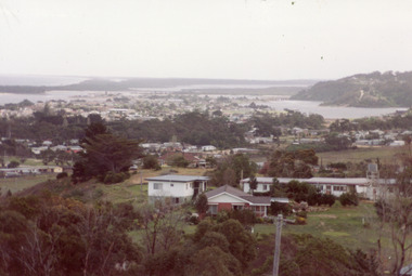
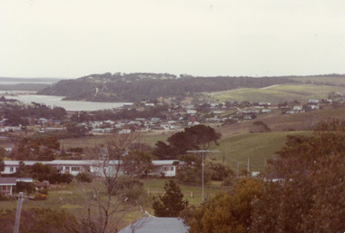
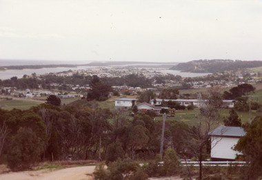
Photograph - Township, Fish, Marie, 1985c
\Colour photograph of township showing, North Arm and North Arm Bridge, Jemmys Point, Mount Barkly, Kalimna Heights on right, Cunninghame Arm and sand dunes on left. Looking towards Bullock Island and Rigby Island and Hopetoun Channel in centre background. Sea Vista flats in foreground. Photo take from near Telecom Tower on Merrangbaur Hill circa 1985. Lakes Entrance Victoria bridges, waterways, township -
 Lakes Entrance Historical Society
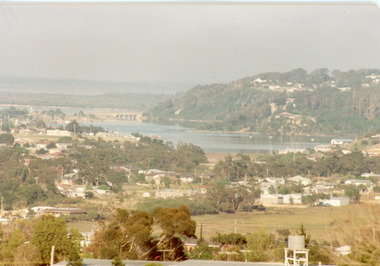
Photograph - Township, Fish, Marie, 1985c
Colour photograph of township showing, North Arm and North Arm Bridge, Jemmys Point, Mount Barkly, Kalimna Heights on right, Cunninghame Arm and sand dunes on left. Looking towards Bullock Island and Rigby Island and Hopetoun Channel in centre background. Sea Vista flats in foreground. Photo take from near Telecom Tower on Merrangbaur Hill circa 1985. Lakes Entrance Victoria bridges, waterways, township -
 Lakes Entrance Historical Society
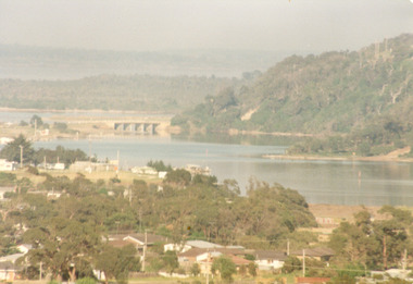
Photograph - Township, Fish, Marie, 1985c
Colour photograph, image of part of township, showing Jemmys Point, Mount Barkly, North Arm and old North Arm bridge, football ground mid picture. View towards Rigby Island, Hopetoun Channel and dunes. Photo taken using telephoto lenses from near Telecom Tower on Merrangbaur Hill. Lakes Entrance Victoria bridges, waterways, township -
 Lakes Entrance Historical Society
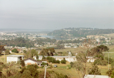
Photograph - Township, Fish, Marie, 1985c
Colour photograph of township, showing buildings, Jemmys Point, Mount Barkly, Kalimna Heights, North Arm and old North Arm bridge, and Rigby Island beyond. Sea Vista flats in foreground. Photo taken from near Telecom Tower on Merrangbaur Hill. Lakes Entrance Victoriatopography, township, waterways, bridges -
 Lakes Entrance Historical Society
Photograph - Township, Fish, Marie, 1985c
Colour photograph of part of township showing Jemmys Point, Mount Barkly, Kalimna Heights, North Arm & old North Arm bridge, looking beyond to Rigby Island. Photo taken from near Telecom Tower on Merrangbaur Hill. Lakes Entrance Victoriatopography, township, waterways, bridges -
 Lakes Entrance Historical Society
Photograph - Township
Colour photograph of township of Lakes Entrance showing North Arm, North Arm Bridge, Jemmys Point, Mount Barclay, Kalimna Heights, Cunningham Arm and sand dunes on left. Looking west to Bullock Island and Rigby Island. Photo taken from near Telecom Tower on Merrangbaur Hill. Lakes Entrance Victoria bridges, waterways, islands, township -
 Warrnambool and District Historical Society Inc.
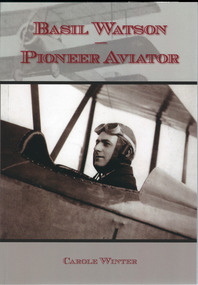
Book, Basil Watson Pioneer Aviator, March 2015
This book gives details on the life and work of Basil Watson (1893-1917), a pioneer aviator in AustraliaThis is a paper back book with a plastic-laminated cover. There are 61 pages with diagrams, photographs, illustrations, advertisements, posters and newspaper cuttings. The cover is mainly grey and white in colour with printed material in a red insert and two photographs superimposed over the background.This book gives details on the life and work of Basil Watson (1893-1917), a pioneer aviator in Australiabasil watson, warrnambool and aviation pioneer, australian aviators -
 Lakes Entrance Historical Society
Photograph - The Entrance, 1910c
Black and white photograph of the Princes Highway at Kalimna. It shows the road around Jemmys Point. Bullock Island and a distant view of the man made entrance. Gumtrees along roadside. Lakes Entrance VictoriaThe Entrance from Princes Highwayroads and streets, vegetation, fences, waterways