Showing 32289 items matching " building"
-
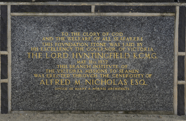 Mission to Seafarers Victoria
Photograph - Digital photograph
Sponsored by Alfred M. Nicholas the Deco era Mission building facing Beach street built by Architect Harry Norris opened in 1937. The building was then in WW2 requisitioned with the Mission returning to full use of the complex some years after the War ended. The building in later years was relinquished due to decreasing shipping at Port Melbourne and need to consolidate seafarers services in the Central Mission at 717 Flinders St. The building was used as an art centre just prior to demolition in the 1990s. The Port Melbourne Historical and Preservation Society was instrumental in ensuring the the old foundation stone was preserved in the sea wall opposite the original site. A single brick from the building is also part of the MtSV Heritage Collection. This stone is one of the few items remaining from this building demolished in 1995.Photograph depicting the foundation stone laid on the 18 May 1937 for the new Mission in Port Melbourne.TO THE GLORY OF GOD/AND THE WELFARE OF ALL SEAFARERS / THIS FOUNDATION STONE WAS LAID BY / HIS EXCELLENCY THE GOVERNOR OF VICTORIA / THE LORD HUNTINGFIELD K.C.M.G. / MAY 18th 1937 / THIS BRANCH INSTITUTE OF / THE VICTORIA MISSIONS TO SEAMEN / WAS ERECTED THROUGH THE GENEROSITY OF / ALFRED M.NICHOLAS ESQ. / OFFICE OF HARRY A.NORRIS ARCHITECTSfoundation stone, lord huntingfield, port melbourne, beach street, art deco, brick, harry a. norris, alfred m. nicholas, maurice nicholas -
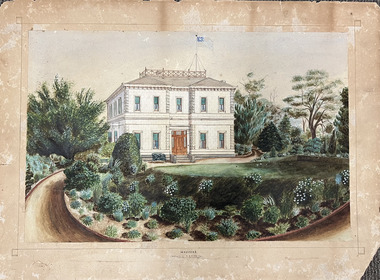 Kew Historical Society Inc
Work on paper, Madford: the property of A.S. King Esq
The Victorian-era mansion Madford in Wellington Street had several incarnations before it was finally demolished. While the precise details of its original construction have not been discovered, we know that it was originally named Elm Lodge, and that the property was offered for sale in 1863 by Thomas Mitchell, of the firm Mitchell & Bonneau, wholesale ironmongers and merchants. The house was sold in about 1873 to William Siddeley (1827-1905), who was described on the occasion of his death as ‘the father of Australian shipping’. The next owner was Arthur Septimus King (1827- 99), who renamed the house Madford after his purchase of the property in 1875. It was A.S. King for whom this artwork was completed. Following King’s death in 1899, portions of the property were sold, including to the Borough of Kew in 1905, to form the Alexandra Gardens. Then, in 1920, the house and its remaining lands were sold to the Catholic Church who opened St Anthony’s Home for Children on the site in 1922. That building was promptly demolished, and the site redeveloped circa 1976.Gift of James Pearson, 2022This fine perspective drawing of the architectural elements of Madford [formerly Elm Lodge, later St Anthony's Home for Babies] is contrasted with the freer addition in watercolour of the layout and plants of the garden facing Wellington Street. The view selected is the south-facing main facade and the west facing side. After A.S. King purchased the house in 1875, it was extended with new wings at the rear to accommodate his large family. There is no indication of these extensions in the painting so its creation must predate the renovations, and probably depicts the original building on the site."MADFORD / The Property of A. S. KING Esq"elm lodge, madford, st anthony's home for babies, houses -- wellington street -- kew (vic.), thomas mitchell, william siddeley, arthur septimus king -
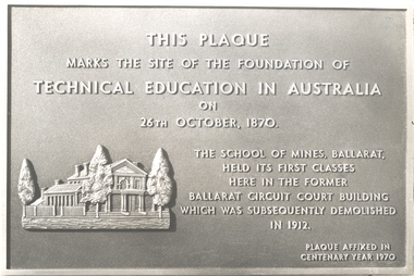 Federation University Historical Collection
Photograph, Ballarat School of Mines Centenary Plaque, 1c970
The Ballarat School of MInes is a predecessor institution of Federation University Australia.This plaque marks the site of the foundation of technical education in Australia on 26th October, 1870. The School of Mines, Ballarat held its first classes here in the former Ballarat Circuit Court Building which was subsequently demolished in 1912. Plaque affixed in centenary year 1970ballarat school of mines, plaque, former ballarat circuit court, centenary, anniversary -
 Mission to Seafarers Victoria
Domestic object - Mug, The Mission to Seafarers; Caring for Seafarers since 1857, 2018
Production of the mugs was inspired by the interest of visitors in purchasing a mug like the ones on display created by an artist Catherine Bell in 2017 for the Sounding Histories exhibitions.This mug added to the Mission collection as a contemporary example of MTSV memorabilia and promotion and features bth current logo and image of the building complex.Pale gray ceramic drinking mug with a mid-blue lining and a large handle (1668). Colour image transfers decorating outer walls.The Mission to Seafarers logo in a blue oval with 'Caring for Seafarers since 1857' printed in blue underneath is printed on the front. On the back in dark gray is a stamped effect of a street scape with Mission buildings with 'www.missiontoseafarers.com.au . On the underside a paper lined is adhered with a printed barcode and price of $12.00. mtsv memorabillia, mug, souvenir, mtsv shop, marketing -
 Federation University Historical Collection
Document, Kim Durban, University of Ballarat Arts Academy Opening Speech, 2012, 15/06/2017
Kim Durban's speech at the opening of the Arts Academy at Camp Street Ballarat.From: Kim Durban Sent: Tuesday, 13 June 2017 3:14 PM To: Clare Gervasoni kim durban, arts academy, opening, camp street -
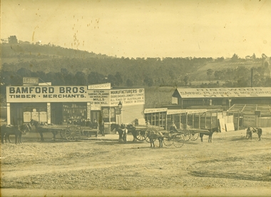 Ringwood and District Historical Society
Photograph, Maroondah Highway Central, Ringwood. Bamford's Timber Yard, 1910
Sepia photographImage shows timber yard with men and horse-drawn vehicle outside building. Warrandyte Road on right leading to Kennedy's orchard. Shop on corner was 'A. Wagner, Hairdresser. Photograph received from a Mr. Harrison, E.S.& A Bank Manager , Frankston. (Peter Paynes photographer). -
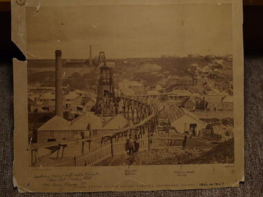 Clunes Museum
Photograph, C. NETTLETON
.1 SEPIA PHOTOGRAPH OF CLUNES UNITED QUARTZ MINE .2 BLACK AND WHITE PHOTO PRINT .3 SMALL BLACK AND WHITE PHOTO PRINT WITH HISTORY WRITTEN ON BACK BY F C WEICKHARDT .4 SMALL BLACK AND WHITE PHOTO PRINT .5 SMALL SEPIA PRINTCLUNES UNITED QUARTZ MINING COMPANY, REGISTERED, CLUNES. WITH HANDWRITTEN NOTES: LOOKING FROM NORTH SIDE OF CREEK NEAR PORT PHILLIP HILL OVER LOWER FRASER STREET VARIOUS NOTATIONS INCLUDING LOCATION OF BUILDINGS, INCLUDING ALBION HOTEL, CRITERION HOTELlocal history, photography, photographs, mining -
 Kew Historical Society Inc
Plan, Borough of Kew Detail Plan No.1577, 1904
The Melbourne and Metropolitan Board of Works (MMBW) plans were produced from the 1890s to the 1950s. They were crucial to the design and development of Melbourne's sewerage and drainage system. The plans, at a scale of 40 feet to 1 inch (1:480), provide a detailed historical record of Melbourne streetscapes and environmental features. Each plan covers one or two street blocks (roughly six streets), showing details of buildings, including garden layouts and ownership boundaries, and features such as laneways, drains, bridges, parks, municipal boundaries and other prominent landmarks as they existed at the time each plan was produced. (Source: State Library of Victoria)This plan forms part of a large group of MMBW plans and maps that was donated to the Society by the Mr Poulter, City Engineer of the City of Kew in 1989. Within this collection, thirty-five hand-coloured plans, backed with linen, are of statewide significance as they include annotations that provide details of construction materials used in buildings in the first decade of the 20th century as well as additional information about land ownership and usage. The copies in the Public Record Office Victoria and the State Library of Victoria are monochrome versions which do not denote building materials so that the maps in this collection are invaluable and unique tools for researchers and heritage consultants. A number of the plans are not held in the collection of the State Library of Victoria so they have the additional attribute of rarity.Original survey plan, issued by the MMBW to a contractor with responsibility for constructing sewers in the area identified on the plan within the Borough of Kew. The plan was at some stage hand-coloured, possibly by the contractor, but more likely by officers working in the Engineering Department of the Borough and later Town, then City of Kew. The hand-coloured sections of buildings on the plan were used to denote masonry or brick constructions (pink), weatherboard constructions (yellow), and public buildings (grey). MMBW Plan No.1577 includes some of the most significant houses in Kew: Herbert Henty’s ‘Roxeth’ (now part of Trinity Grammar), ‘Butleigh Wooton’, ‘Bokara’ and ‘Harrow’. It also includes the streets that have since changed their names. That part of College Parade linked to Glenferrie Road is now named College Place, College Parade now extends further north, and Charles Street did not yet reach Barkers Road. Roxeth is one of a number of Henty houses in Kew. Herbert Henty made his home here and was elected a member of Kew Municipal Council in 1864 and mayor in 1868-69. Walter Henry Serle, of Harrow served in the First World War. He was awarded the Military Medal ‘’For conspicuous bravery and devotion to duty. On 29th September near BELLICOURT he showed the greatest bravery and determination when his platoon was attacked by enemy bombing parties. It was due largely to his personal efforts that all the attacks were repulsed. Until wounded, his utter disregard of personal safety and boldness in dealing with the attacks were the means of saving the situation and were an inspiring example to his men.’melbourne and metropolitan board of works, detail plans, maps - borough of kew, mmbw 1577, cartography -
 Kew Historical Society Inc
Plan, Melbourne & Metropolitan Board of Works : Borough of Kew : Detail Plan No.1588, 1904
The Melbourne and Metropolitan Board of Works (MMBW) plans were produced from the 1890s to the 1950s. They were crucial to the design and development of Melbourne's sewerage and drainage system. The plans, at a scale of 40 feet to 1 inch (1:480), provide a detailed historical record of Melbourne streetscapes and environmental features. Each plan covers one or two street blocks (roughly six streets), showing details of buildings, including garden layouts and ownership boundaries, and features such as laneways, drains, bridges, parks, municipal boundaries and other prominent landmarks as they existed at the time each plan was produced. (Source: State Library of Victoria)This plan forms part of a large group of MMBW plans and maps that was donated to the Society by the Mr Poulter, City Engineer of the City of Kew in 1989. Within this collection, thirty-five hand-coloured plans, backed with linen, are of statewide significance as they include annotations that provide details of construction materials used in buildings in the first decade of the 20th century as well as additional information about land ownership and usage. The copies in the Public Record Office Victoria and the State Library of Victoria are monochrome versions which do not denote building materials so that the maps in this collection are invaluable and unique tools for researchers and heritage consultants. A number of the plans are not held in the collection of the State Library of Victoria so they have the additional attribute of rarity.Original survey plan, issued by the MMBW to a contractor with responsibility for constructing sewers in the area identified on the plan within the Borough of Kew. The plan was at some stage hand-coloured, possibly by the contractor, but more likely by officers working in the Engineering Department of the Borough and later Town, then City of Kew. The hand-coloured sections of buildings on the plan were used to denote masonry or brick constructions (pink), weatherboard constructions (yellow), and public buildings (grey). This plan shows the original configuration of the Kew Post Office, Court House and Police Station, which had opened in 1888. This configuration was to essentially remain until the purchase of the Court House and Police Station by the City of Boroondara in 2007 and its subsequent renovation. Interestingly, the MMBW surveyors incorrectly labelled parts of the complex. In the triangle in front of the Post Office, before the erection of the Kew Cenotaph in 1925, was located a lawn and the Queen Victoria Jubilee Fountain. While many of the shops on the south side of High street had been constructed by 1903 a number of sites were still used as vegetable gardens. Further along High Street, on the corner of Charles Street, the Salvation Army Barracks can be seen on the plan. These Barracks predate the later Citadel and ‘Young People’s Hall’ that were opened in 1919. At 22 Charles Street can be seen the house of James Venn Morgan. Hailed as the ‘father of Kew’, Morgan arrived in Melbourne in 1840. He was first engaged as a bookmaker, but a fortunate venture on the goldfields enabled him to purchase land in Kew. He conducted a market garden and dairy in Kew for many years.melbourne and metropolitan board of works, detail plans, maps - borough of kew, mmbw 1588, cartography -
 Kew Historical Society Inc
Plan, Melbourne & Metropolitan Board of Works : Borough of Kew : Detail Plan No.1591, 1905
The Melbourne and Metropolitan Board of Works (MMBW) plans were produced from the 1890s to the 1950s. They were crucial to the design and development of Melbourne's sewerage and drainage system. The plans, at a scale of 40 feet to 1 inch (1:480), provide a detailed historical record of Melbourne streetscapes and environmental features. Each plan covers one or two street blocks (roughly six streets), showing details of buildings, including garden layouts and ownership boundaries, and features such as laneways, drains, bridges, parks, municipal boundaries and other prominent landmarks as they existed at the time each plan was produced. (Source: State Library of Victoria)This plan forms part of a large group of MMBW plans and maps that was donated to the Society by the Mr Poulter, City Engineer of the City of Kew in 1989. Within this collection, thirty-five hand-coloured plans, backed with linen, are of statewide significance as they include annotations that provide details of construction materials used in buildings in the first decade of the 20th century as well as additional information about land ownership and usage. The copies in the Public Record Office Victoria and the State Library of Victoria are monochrome versions which do not denote building materials so that the maps in this collection are invaluable and unique tools for researchers and heritage consultants. A number of the plans are not held in the collection of the State Library of Victoria so they have the additional attribute of rarity.Original survey plan, issued by the MMBW to a contractor with responsibility for constructing sewers in the area identified on the plan within the Borough of Kew. The plan was at some stage hand-coloured, possibly by the contractor, but more likely by officers working in the Engineering Department of the Borough and later Town, then City of Kew. The hand-coloured sections of buildings on the plan were used to denote masonry or brick constructions (pink), weatherboard constructions (yellow), and public buildings (grey). That area of Kew bordered by Cotham Road, Park Hill Road, Ermington Lane (now Ermington Place), and Belmont Avenue contained some of the significant homes owned by Kew pioneers. Chief among these was ‘Park Hill’ on an enormous lot facing Park Hill Road. The Jubilee History of 1910 noted, six years after this plan was drawn, that: ‘Park Hill Road, forming the southern boundary of the cemetery, takes its name from Park Hill, the residence of Mr. Thomas Judd, who has resided there since December, 1852.’ Other named houses on the plan include ‘Ferndale’ facing Cotham Road; ‘Ermington’ adjacent to Judd’s Park Hill, facing Park Hill Road; and ‘Gilden’ and ‘Mont Belmont’ facing Belmont Avenue. Mont Belmont was designed by the architectural firm of Reed, Henderson and Smart for William George Lilley in 1887 and was completed in 1888. Lilley was Mayor of Kew in 1887-88, a Justice of the Peace and a member of the first Board of Guardians of Kew’s St. Hilary’s Church of England.melbourne and metropolitan board of works, detail plans, survey plans - borough of kew, mmbw 1591, cartography -
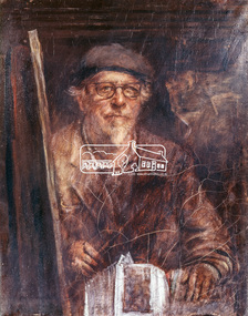 Eltham District Historical Society Inc
Photograph, Jorgensen, Justus, 1893-1975, Self portrait, Justus Jorgensen, founder of Montsalvat, c.1955
Founder of Montsalvat Reproduced Page 106 of Pioneers & Painters, edited by Alan Marshall (1971) Note: print in book and print copy are mirror imaged There was probably little earth building done in the district in this century until 1934, when Justus Jorgensen, architect and artist, bought land in Eltham and with his students and followers commenced to build the fascinating complex of buildings now know as ‘Montsalvat’. These buildings and his use of materials, both local stone and earth, and reclaimed materials, were to have a remarkable influence on the Eltham district-particularly in the period following World War II. The first building at ‘Montsalvat’ was a picturesque house of or rammed earth with a high-pitched roof. Jorgensen has used a variety of building materials but it is possibly his use of earth, both pise-de-terre and mud brick, which has had the most influence on the environmental building in Eltham in the post war years. By the end of the 1940s, an impressive array of adobe and pise buildings had been completed. – Alan Marshall, 1971, “Pioneers & Painters”This photo forms part of a collection of photographs gathered by the Shire of Eltham for their centenary project book,"Pioneers and Painters: 100 years of the Shire of Eltham" by Alan Marshall (1971). The collection of over 500 images is held in partnership between Eltham District Historical Society and Yarra Plenty Regional Library (Eltham Library) and is now formally known as the 'The Shire of Eltham Pioneers Photograph Collection.' It is significant in being the first community sourced collection representing the places and people of the Shire's first one hundred years.Digital image 4 x 5 inch Clr Reversal (3) Print 21 x 16.5 cm (printed in mirror image)justus jorgensen, montsalvat, pioneers and painters, shire of eltham pioneers photograph collection -
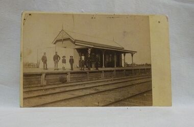 Wycheproof & District Historical Society Inc.
Sepia photo, Photographer unknown, Historic Wycheproof Railway Station, 1904 (estimated)
This railway station building was erected in 1887 and closed in 1990. Now a new chapter begins with a newly restored station building amd platform that re-opened in October 2010 to be used by the Wycheproof Community.The Wycheproof Railway station constructed by Hossack & Brown in 1887 is Heritage listed and is on the Government Buildings Register. This photo is one of only a few available of the early days of the Station.The complex is historically significant at a State level AHC A.4. The Railway station contains significant detailing such as in the turned timber posts and overall composition. This early photo of Wycheproof railway station, shows a construction of timber with corrugated iron clad roof,in c.1904. Features of the design are the timber verandah posts with decorative elements which include chamfers and supporting diagonal timber brackets. The gabled roof has finials on the east and west ends. Seven people pose on the platform,the staff in uniform of the times.Nilregister, , railways, wycheproof, historic buildings, 1900s -
Alexandra Timber Tramway & Museum
Mr Sapsford, rubicon .Near power house (tin hut)
Power house was called the tin hut by those who built it and other locals . the building of Rubicon power house was helped by the timber indusary .As the timber and locals were helped by the building and supply of powerUn replaceablerubicon photo black and white of power house ,in forground chonnel running over the rubicon river , mens camp for workers in back ground . taken by Mr Sapsford of Alexandar . in good condrubicon . near power house (tin hut) -
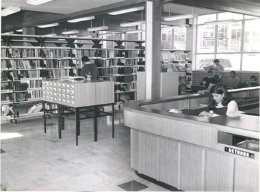 Federation University Historical Collection
Photograph - Photograph - Black and White, Mount Helen Library, c1972, pre 1973
The library depicted in the photograph was the temporary library used before a library building was built on the Mt Helen Campus. The temporary library was in the ground floor of F building, near the 2009 office number 212. Two photographs relating to the first library at the Mt Helen Campus (Ballarat Institute of Advanced Education). .1) A female and males stands at a bookcase - as of 18/06/2019 this photo is unavailable. .2) The library loans deskballarat institute of advanced education, library, mt helen, dunn, cochrane, librarian -
City of Moorabbin Historical Society (Operating the Box Cottage Museum)
Book - The Living Harvest - A history of St. Peter's Parish, East Bentleigh, by W. T. Dobson, 1974
The first building that was erected in the Parish of St Peter's was a little wooden school house, built by local market gardeners in February 1865. The school was demolished and a brick school building was erected and opened in1903. St Peter's School, East Bentleigh was erected by the many Irish Market Gardeners of Moorrabin in 1865 and was integral to the education, spiritual well being and social life of the early settlers.A book on the history of St Peter's Parish, Centre Road, East Bentleigh, with pictures. 57 pages. Contains local history, history of early pioneer families, St Peter's School and the church.early settlers, parish of moorabbin, city of moorabbin, county of bourke, shire of moorabbin, market gardeners, center road, irish settlers, east bentleigh, st peter's church east bentleigh, religion, catholic -
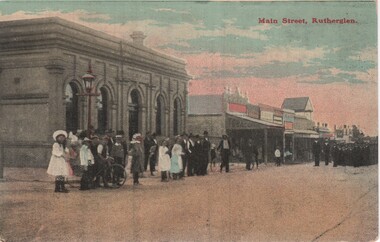 Rutherglen Historical Society
Image, F. Harrison, Main Street, Rutherglen, c1890
View is from the corner of Main and High Streets. On the corner is the bank that is now the NAB. Further along the road, with the gabled roof above the other buildings, is the Rutherglen Hotel while it was still a weatherboard building.Coloured postcard photograph, showing a view of Main Street Rutherglen with a group of people waiting to see the parade coming up the street.Printed on back of card: "Published by F. Harrison, Rutherglen"main street, parades, rutherglen hotel, banks -
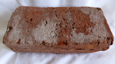 Warrnambool and District Historical Society Inc.
Functional object - Brick, 94 Merri Street Warrnambool, Circa 1850
The building at 94 Merri St is amongst the earliest buildings in Warrnambool. It was possibly constructed before 1854 and maybe as early as 1848. The original building consisted of four main rooms under a hip roof. The outer walls were masonry , apparently rubble The Heritage Council indcate that on the balance of probabilities this was the general store of Richard Osbourne and John Moffat Chisholm built in 1847-48.The building at 94 Merri Street had historical and architectural significance to the state of Victoria. It was a rare example of surviving, pre separation building with associated interest in its materials and components It is associated with Richard Osbourne who founded the Warrnambool Examiner(1851_1889) and the town’s first historian. Architecturally, the significance of the house lay in the hand -wrought timber framing. All the major timbers in this building had been hand sawn. The Gold rush of the 1850’s saw this process mechanised. A kitchen fireplace in the rear skillion included a large block of Merri Creek Mudstone, a combination of “tufa” and clay that was used in the Warrnambool District as an excellent substitute for fire bricks. The house was demolished in 2011 and items of significance were salvaged, this brick being one. While some bricks were imported, there is evidence that there were a number of brick burning businesses in operation around this time. However it is difficult to ascertain to which group this brick belongs. Red clay rectangular brick. Contains some small gravel like material, possibly ferrous buckshot, grey mortar remnants on side and diagonal crack along one side.warrnambool, 94 merri street, richard osbourne, john moffat chisholm, hand sawn timber, brick, building materials -
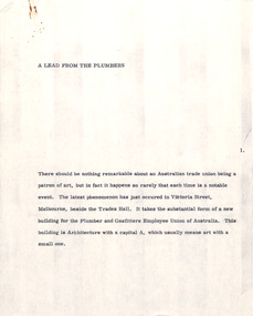 Robin Boyd Foundation
Document - Manuscript, Robin Boyd, A Lead From the Plumbers, 1971
Boyd discusses Graeme Gunn's Plumbers & Gasfitters Employees Union Building; indicates it is unusual for Australian trade unions to be a patron of the arts; discusses the angular design and its raw concrete, which Boyd praises as internationally fashionable; suggests that the last great piece of union-commissioned architecture was the Wharf Labourers' Union building, a 1916 Art Nouveau building by Robert Haddon.Original manuscript of an article published in "The Sunday Australian", 06.06.1971 (Review of Graeme Gunn’s Plumbers and Gas Fitters Building, Victoria Parade, Carlton).Typewritten (c copy), quarto, 7 pagestrade unions, plumbers and gasfitters employees union of australia, graeme gunn, brutalism, concrete, robert haddon, wharf labourers' union building, flinders st, robin boyd, manuscript -
Port Melbourne Historical & Preservation Society
Map - MMBW Map Area No 56, after 1911
The map is based on the 1894 MMBW map (Cat No 271) but shows buildings that were constructed after this date. In particular houses in Bridge Street between Williamstown Road and Derham Street, buildings between the right of way and Derham Street and Williamstown Road including an A T Harmon building constructed in 1911. There are also houses at the top end of Derham Street near Williamstown Road.Photocopy of a section of a larger MMBW map created after 1911.engineering - board of works, built environment, alfred thomas harmon -
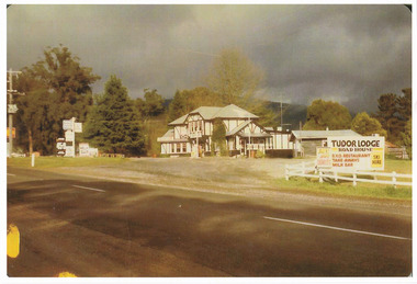
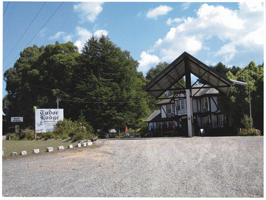 Marysville & District Historical Society
Photograph (item) - Colour photograph, Unknown
A colour photograph of Tudor Lodge Roadhouse in Narbethong in Victoria. After being known as Misty Hills Guest House it became Tudor Lodge Cafe then Tudor Lodge Roadhouse. The building was destroyed in the 2009 Black Saturday bushfires. The building was subsequently rebuilt albeit as a smaller building and was known as Wombat Cottage. That business was then sold and the property is now known as Oaktree Guest House.A colour photograph of Tudor Lodge Roadhouse in Narbethong in Victoria.narbethong, victoria, tudor lodge roadhouse, tudor house cafe, misty hills guest house, 2009 black saturday bushfires, oaktree guest house, accommodation, photograph, wombat cottage -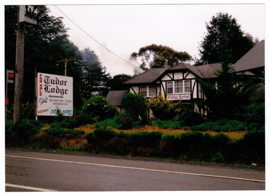
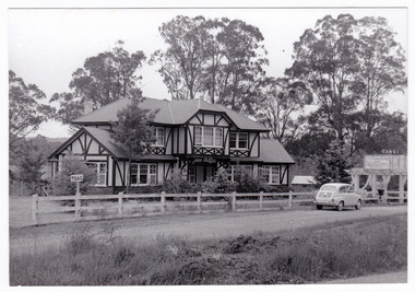 Marysville & District Historical Society
Photograph (Item) - Black and white photograph, Unknown
A black and white photograph of Tudor Lodge Cafe in Narbethong in Victoria. After being known as Misty Hills Guest House it became Tudor Lodge Cafe then Tudor Lodge Roadhouse. The building was destroyed in the 2009 Black Saturday bushfires. The building was subsequently rebuilt albeit as a smaller building and was known as Wombat Cottage. That business was then sold and the property is now known as Oaktree Guest House.A black and white photograph of Tudor Lodge Cafe in Narbethong in Victoria. narbethong, victoria, tudor lodge cafe, misty hills guest house, tudor lodge roadhouse, oaktree guest house, photograph, accommodation, wombat cottage, 2009 black saturday bushfires -
 Marysville & District Historical Society
Photograph (item) - Colour photograph, Unknown
A colour photograph of Tudor Lodge Roadhouse in Narbethong in Victoria. After being known as Misty Hills Guest House it became Tudor Lodge Cafe then Tudor Lodge Roadhouse. The building was destroyed in the 2009 Black Saturday bushfires. The building was subsequently rebuilt albeit as a smaller building and was known as Wombat Cottage. That business was then sold and the property is now known as Oaktree Guest House.A colour photograph of Tudor Lodge Roadhouse in Narbethong in Victoria.narbethong, victoria, tudor lodge roadhouse, photograph, accommodation, 2009 black saturday bushfires, oaktree guest house, misty hills guest house, tudor lodge cafe, wombat cottage -
Federation University Historical Collection
Photograph, Ballarat Junior Technical School
A perspective view of a two storey building -
Federation University Historical Collection
Photograph, Ballarat State Offices, 1980s
This building is known locally as the glass houseBallarat State Offices on the corner of Mair Street and Doveton Street North.ballarat state offices, glass house -
Port Melbourne Historical & Preservation Society
Photograph - Port Melbourne Police Station and lock-up, Jim Hillis, 1996
Taken by Jim HILLIS as a record of the buildingsPhoto of window and ceiling of cell One of a set of photographs of Port Melbourne police station and lock up taken by Jim HILLIS in 1996 when PMH&PS representatives were given a tour after station was vacated by police:built environment - civic, police, law, police station -
Port Melbourne Historical & Preservation Society
Photograph - Port Melbourne Police Station and lock-up, Jim Hillis, 1996
Taken by Jim HILLIS as a record of the buildingsPhoto of filing cabinet One of a set of photographs of Port Melbourne police station and lock up taken by Jim HILLIS in 1996 when PMH&PS representatives were given a tour after station was vacated by police:built environment - civic, police, law, police station -
Port Melbourne Historical & Preservation Society
Photograph - Port Melbourne Police Station and lock-up, Jim Hillis, 1996
Taken by Jim HILLIS as a record of the buildingsPhoto of old desk One of a set of photographs of Port Melbourne police station and lock up taken by Jim HILLIS in 1996 when PMH&PS representatives were given a tour after station was vacated by police:built environment - civic, police, law, police station -
Port Melbourne Historical & Preservation Society
Photograph - Port Melbourne Police Station and lock-up, Jim Hillis, 1996
Taken by Jim HILLIS as a record of the buildingsPhoto of outside cell block One of a set of photographs of Port Melbourne police station and lock up taken by Jim HILLIS in 1996 when PMH&PS representatives were given a tour after station was vacated by police:built environment - civic, police, law, police station -
Port Melbourne Historical & Preservation Society
Photograph - Port Melbourne Police Station and lock-up, Jim Hillis, 1996
Taken by Jim HILLIS as a record of the buildingsPhoto of under stairway, station One of a set of photographs of Port Melbourne police station and lock up taken by Jim HILLIS in 1996 when PMH&PS representatives were given a tour after station was vacated by police:built environment - civic, police, law, police station