Showing 33952 items
matching building-fittings
-
 Federation University Historical Collection
Document, Kim Durban, University of Ballarat Arts Academy Opening Speech, 2012, 15/06/2017
Kim Durban's speech at the opening of the Arts Academy at Camp Street Ballarat.From: Kim Durban Sent: Tuesday, 13 June 2017 3:14 PM To: Clare Gervasoni kim durban, arts academy, opening, camp street -
 Ringwood and District Historical Society
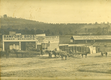
Photograph, Maroondah Highway Central, Ringwood. Bamford's Timber Yard, 1910
Sepia photographImage shows timber yard with men and horse-drawn vehicle outside building. Warrandyte Road on right leading to Kennedy's orchard. Shop on corner was 'A. Wagner, Hairdresser. Photograph received from a Mr. Harrison, E.S.& A Bank Manager , Frankston. (Peter Paynes photographer). -
 Clunes Museum
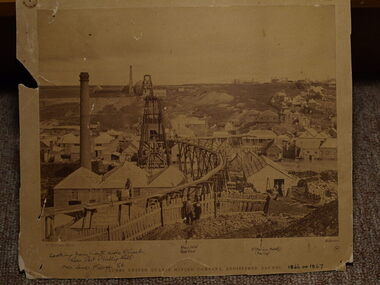
Photograph, C. NETTLETON PHOTOGRAPHER
.1 SEPIA PHOTOGRAPH OF CLUNES UNITED QUARTZ MINE .2 BLACK AND WHITE PHOTO PRINT .3 SMALL BLACK AND WHITE PHOTO PRINT WITH HISTORY WRITTEN ON BACK BY F C WEICKHARDT .4 SMALL BLACK AND WHITE PHOTO PRINT .5 SMALL SEPIA PRINTCLUNES UNITED QUARTZ MINING COMPANY, REGISTERED, CLUNES. WITH HANDWRITTEN NOTES: LOOKING FROM NORTH SIDE OF CREEK NEAR PORT PHILLIP HILL OVER LOWER FRASER STREET VARIOUS NOTATIONS INCLUDING LOCATION OF BUILDINGS, INCLUDING ALBION HOTEL, CRITERION HOTELlocal history, photography, photographs, mining -
 Kew Historical Society Inc
Plan, Borough of Kew Detail Plan No.1577, 1904
The Melbourne and Metropolitan Board of Works (MMBW) plans were produced from the 1890s to the 1950s. They were crucial to the design and development of Melbourne's sewerage and drainage system. The plans, at a scale of 40 feet to 1 inch (1:480), provide a detailed historical record of Melbourne streetscapes and environmental features. Each plan covers one or two street blocks (roughly six streets), showing details of buildings, including garden layouts and ownership boundaries, and features such as laneways, drains, bridges, parks, municipal boundaries and other prominent landmarks as they existed at the time each plan was produced. (Source: State Library of Victoria)This plan forms part of a large group of MMBW plans and maps that was donated to the Society by the Mr Poulter, City Engineer of the City of Kew in 1989. Within this collection, thirty-five hand-coloured plans, backed with linen, are of statewide significance as they include annotations that provide details of construction materials used in buildings in the first decade of the 20th century as well as additional information about land ownership and usage. The copies in the Public Record Office Victoria and the State Library of Victoria are monochrome versions which do not denote building materials so that the maps in this collection are invaluable and unique tools for researchers and heritage consultants. A number of the plans are not held in the collection of the State Library of Victoria so they have the additional attribute of rarity.Original survey plan, issued by the MMBW to a contractor with responsibility for constructing sewers in the area identified on the plan within the Borough of Kew. The plan was at some stage hand-coloured, possibly by the contractor, but more likely by officers working in the Engineering Department of the Borough and later Town, then City of Kew. The hand-coloured sections of buildings on the plan were used to denote masonry or brick constructions (pink), weatherboard constructions (yellow), and public buildings (grey). MMBW Plan No.1577 includes some of the most significant houses in Kew: Herbert Henty’s ‘Roxeth’ (now part of Trinity Grammar), ‘Butleigh Wooton’, ‘Bokara’ and ‘Harrow’. It also includes the streets that have since changed their names. That part of College Parade linked to Glenferrie Road is now named College Place, College Parade now extends further north, and Charles Street did not yet reach Barkers Road. Roxeth is one of a number of Henty houses in Kew. Herbert Henty made his home here and was elected a member of Kew Municipal Council in 1864 and mayor in 1868-69. Walter Henry Serle, of Harrow served in the First World War. He was awarded the Military Medal ‘’For conspicuous bravery and devotion to duty. On 29th September near BELLICOURT he showed the greatest bravery and determination when his platoon was attacked by enemy bombing parties. It was due largely to his personal efforts that all the attacks were repulsed. Until wounded, his utter disregard of personal safety and boldness in dealing with the attacks were the means of saving the situation and were an inspiring example to his men.’melbourne and metropolitan board of works, detail plans, maps - borough of kew, mmbw 1577, cartography -
 Kew Historical Society Inc
Plan, Melbourne & Metropolitan Board of Works : Borough of Kew : Detail Plan No.1588, 1904
The Melbourne and Metropolitan Board of Works (MMBW) plans were produced from the 1890s to the 1950s. They were crucial to the design and development of Melbourne's sewerage and drainage system. The plans, at a scale of 40 feet to 1 inch (1:480), provide a detailed historical record of Melbourne streetscapes and environmental features. Each plan covers one or two street blocks (roughly six streets), showing details of buildings, including garden layouts and ownership boundaries, and features such as laneways, drains, bridges, parks, municipal boundaries and other prominent landmarks as they existed at the time each plan was produced. (Source: State Library of Victoria)This plan forms part of a large group of MMBW plans and maps that was donated to the Society by the Mr Poulter, City Engineer of the City of Kew in 1989. Within this collection, thirty-five hand-coloured plans, backed with linen, are of statewide significance as they include annotations that provide details of construction materials used in buildings in the first decade of the 20th century as well as additional information about land ownership and usage. The copies in the Public Record Office Victoria and the State Library of Victoria are monochrome versions which do not denote building materials so that the maps in this collection are invaluable and unique tools for researchers and heritage consultants. A number of the plans are not held in the collection of the State Library of Victoria so they have the additional attribute of rarity.Original survey plan, issued by the MMBW to a contractor with responsibility for constructing sewers in the area identified on the plan within the Borough of Kew. The plan was at some stage hand-coloured, possibly by the contractor, but more likely by officers working in the Engineering Department of the Borough and later Town, then City of Kew. The hand-coloured sections of buildings on the plan were used to denote masonry or brick constructions (pink), weatherboard constructions (yellow), and public buildings (grey). This plan shows the original configuration of the Kew Post Office, Court House and Police Station, which had opened in 1888. This configuration was to essentially remain until the purchase of the Court House and Police Station by the City of Boroondara in 2007 and its subsequent renovation. Interestingly, the MMBW surveyors incorrectly labelled parts of the complex. In the triangle in front of the Post Office, before the erection of the Kew Cenotaph in 1925, was located a lawn and the Queen Victoria Jubilee Fountain. While many of the shops on the south side of High street had been constructed by 1903 a number of sites were still used as vegetable gardens. Further along High Street, on the corner of Charles Street, the Salvation Army Barracks can be seen on the plan. These Barracks predate the later Citadel and ‘Young People’s Hall’ that were opened in 1919. At 22 Charles Street can be seen the house of James Venn Morgan. Hailed as the ‘father of Kew’, Morgan arrived in Melbourne in 1840. He was first engaged as a bookmaker, but a fortunate venture on the goldfields enabled him to purchase land in Kew. He conducted a market garden and dairy in Kew for many years.melbourne and metropolitan board of works, detail plans, maps - borough of kew, mmbw 1588, cartography -
 Kew Historical Society Inc
Plan, Melbourne & Metropolitan Board of Works : Borough of Kew : Detail Plan No.1591, 1905
The Melbourne and Metropolitan Board of Works (MMBW) plans were produced from the 1890s to the 1950s. They were crucial to the design and development of Melbourne's sewerage and drainage system. The plans, at a scale of 40 feet to 1 inch (1:480), provide a detailed historical record of Melbourne streetscapes and environmental features. Each plan covers one or two street blocks (roughly six streets), showing details of buildings, including garden layouts and ownership boundaries, and features such as laneways, drains, bridges, parks, municipal boundaries and other prominent landmarks as they existed at the time each plan was produced. (Source: State Library of Victoria)This plan forms part of a large group of MMBW plans and maps that was donated to the Society by the Mr Poulter, City Engineer of the City of Kew in 1989. Within this collection, thirty-five hand-coloured plans, backed with linen, are of statewide significance as they include annotations that provide details of construction materials used in buildings in the first decade of the 20th century as well as additional information about land ownership and usage. The copies in the Public Record Office Victoria and the State Library of Victoria are monochrome versions which do not denote building materials so that the maps in this collection are invaluable and unique tools for researchers and heritage consultants. A number of the plans are not held in the collection of the State Library of Victoria so they have the additional attribute of rarity.Original survey plan, issued by the MMBW to a contractor with responsibility for constructing sewers in the area identified on the plan within the Borough of Kew. The plan was at some stage hand-coloured, possibly by the contractor, but more likely by officers working in the Engineering Department of the Borough and later Town, then City of Kew. The hand-coloured sections of buildings on the plan were used to denote masonry or brick constructions (pink), weatherboard constructions (yellow), and public buildings (grey). That area of Kew bordered by Cotham Road, Park Hill Road, Ermington Lane (now Ermington Place), and Belmont Avenue contained some of the significant homes owned by Kew pioneers. Chief among these was ‘Park Hill’ on an enormous lot facing Park Hill Road. The Jubilee History of 1910 noted, six years after this plan was drawn, that: ‘Park Hill Road, forming the southern boundary of the cemetery, takes its name from Park Hill, the residence of Mr. Thomas Judd, who has resided there since December, 1852.’ Other named houses on the plan include ‘Ferndale’ facing Cotham Road; ‘Ermington’ adjacent to Judd’s Park Hill, facing Park Hill Road; and ‘Gilden’ and ‘Mont Belmont’ facing Belmont Avenue. Mont Belmont was designed by the architectural firm of Reed, Henderson and Smart for William George Lilley in 1887 and was completed in 1888. Lilley was Mayor of Kew in 1887-88, a Justice of the Peace and a member of the first Board of Guardians of Kew’s St. Hilary’s Church of England.melbourne and metropolitan board of works, detail plans, survey plans - borough of kew, mmbw 1591, cartography -
 Bendigo Historical Society Inc.
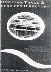
Book - LONG GULLY HISTORY GROUP COLLECTION:HERITAGE TRADE & SERVICES DIRECTORY
Copy of a Heritage Trade & Services Directory Edition 1, dated April 2001. Compiled by City of Greater Bendigo Heritage Advisory Committee. Front cover has an oval picture of part of a building with scaffolding in front of it. Listed are: Architectural Hardware; Architects; Blacksmiths; Brickwork - General; Builders; Castings - Iron and Non Ferrous Metals; Cement Decoration and Rendering; Chimney Pots; Chimney Restoration; Chimney Sweeps; Colour Consultant; Concrete - Pre-cast; Damp Control; Drafting Service; Fabric; Fencing; Fire Mantels and Inserts; Floor Coverings; Furniture Restoration and French Polishing; Garden Renovations; Glass - Etching; Glass - Leadlighting; Guttering, Galvanised Iron and Sheet Metal Work; Interior Decorating; Joinery and Carpentry; Light Fittings; Masonry Cleaning; Paint; Painters and Decorators; Paint Stripping; Plasters and Associated Products; Resurfacing - Enameling; Resurfacing - Powder Coating; Restumping and Underpinning; Roof Restoration - Iron; Roof Restoration - Slate; Roof Restoration - Terracotta; Second Hand Materials; Stone - Quarries and Cutting; Stonemasons; Tile Layers; Tiles; Turning and Verandah Roofing.bendigo, history, long gully history group, the long gully history group - heritage trade & services directory, heritage advisory committee, city of greater bendigo -
 Sunbury Family History and Heritage Society Inc.
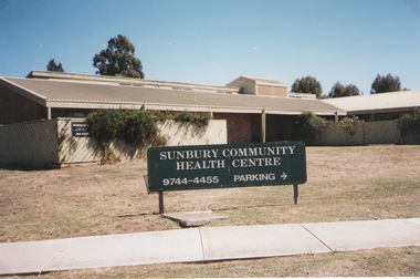
Photograph, Elwyn Davis, Former Sunbury Community Health Centre, March 2002
The first Sunbury Community Health Centre was built on the corner of Horne Street and Gap Road in a temporary building. As result of further funding in 1974, a permanent building was erected and opened in 1981 and operated from that site until 2000 when it was relocated into a larger and more modern building on the former Sunbury Primary School site in Macedon Street to accommodate Sunbury's expanding population and needs.It now operates under the name of Sunbury and Cobaw Community Health Centre. The old building was demolished and replaced with a fast-food outlet.A non-digital coloured photograph of the Sunbury Community Health Centre showing the notice board displayed in the front giving phone details and parking area.sunbury community health centre, health centres, gap road, horne street -
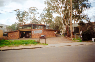 Eltham District Historical Society Inc
Photograph, 23 Brougham Street, Eltham, July 2009, 2009
Alistair Knox designed buildingTwo colour photographsindustries, brougham street, diamond valley antiques and collectables, alistair knox -
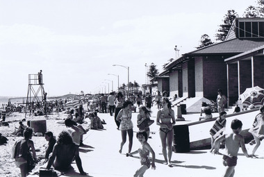 St Kilda Historical Society
Photograph, Elwood Beach
Shows buildings and people on beachblack and white photograph, unmounted, original, good conditionOn back: Elwood Beach -
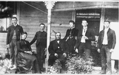 Malmsbury Historical Society
Photograph (Item), "Lasslett Family, Possibly William Lasslett Jnr", Malmsbury
People - Lasslett Buildings - House -
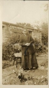 Malmsbury Historical Society
Photograph (Item), Mrs Crowe At Birth Room Malmsbury, Malmsbury
Buildings - Birthing Room Malmsbury -
 Malmsbury Historical Society
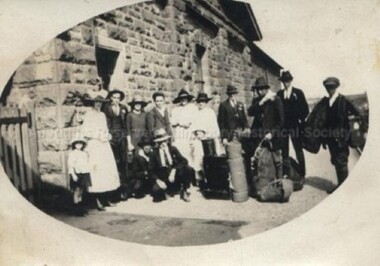
Photograph (Item), Group Of People Outside Malmsbury Station, Malmsbury
Buildings - Station Associated with - Railways -
Malmsbury Historical Society
Photograph (Item), St John'S Anglican Church Altar Window Malmsbury, Malmsbury ca1990
Buildings - St John'S Church -
Malmsbury Historical Society
Photograph (Item), St John'S Church At Malmsbury, Malmsbury ca1990
Buildings - St John'S Church -
Malmsbury Historical Society
Photograph (Item), Church Of England, Malmsbury ca1970
Buildings - St John's Church -
Malmsbury Historical Society
Photograph (Item), Church Of England, Malmsbury ca1970
Buildings - St John's Church -
Malmsbury Historical Society
Photograph (Item), Cobb & Co Depot Cnr Of Patterson & Dalesford Rd, Malmsbury ca1970
Buildings - Cob & Co Depot -
Malmsbury Historical Society
Photograph (Item), Malmsbury Railway Station, Malmsbury ca1980
Buildings - Malmsbury Railway Station -
Malmsbury Historical Society
Photograph (Item), Malmsbury Railway Station, Malmsbury ca1980
Buildings - Malmsbury Railway Station -
Malmsbury Historical Society
Photograph (Item), St John's Church Of England Malmsbury Inside Damage, Malmsbury ca1980/90
Buildings - St-John's Church -
Malmsbury Historical Society
Photograph (Item), St John's Church Of England Malmsbury, Malmsbury ca1980/90
Buildings - St-John's Church -
Malmsbury Historical Society
Photograph (Item), St John's Church Of England Malmsbury Drying Out Knave, Malmsbury ca1980/90
Buildings - St-John's Church -
Malmsbury Historical Society
Photograph (Item), ront Of St John's Church Of England Malmsbury, Malmsbury ca1980/90
Buildings - St-John's Church -
Malmsbury Historical Society
Photograph (Item), Stained Glass Window Of St John's Church Malmsbury, Malmsbury ca1980/90
Buildings - St-John's Church -
Malmsbury Historical Society
Photograph (Item), Stained Glass Window Of St John's Church Malmsbury, Malmsbury ca1980/90
Buildings - St-John's Church -
Malmsbury Historical Society
Photograph (Item), Gold Leaf Inscription At St John's Church Malsbury, Malmsbury ca1980/90
Buildings - St-John's Church -
Malmsbury Historical Society
Photograph (Item), Central Arch Of Sanctuary Window At St John's Church, Malmsbury ca1980/90
Buildings - St-John's Church -
Malmsbury Historical Society
Photograph (Item), Water Damage To Ceiling At St John's Church, Malmsbury ca1980/90
Buildings - St-John's Church -
Malmsbury Historical Society
Photograph (Item), St John's Church Showing Lauristinas At F/Steps, Malmsbury ca1980/90
Buildings - St-John's Church