Showing 12580 items matching " development"
-
 Port Fairy Historical Society Museum and Archives
Photograph
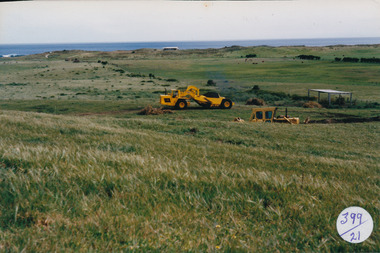
South Beach DevelopementColoured photograph of Land works near South Beach with earth moving equipmentsouth beach, development -
 Lakes Entrance Historical Society
Photograph - Bullock Island, 1991
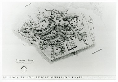
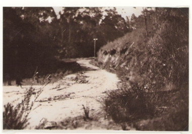
Date made September 1991Black and white photograph of a concept plan for a proposed multi million dollar tourism complex to be built on Bullock Island, Lakes Entrance, Victoria.Bullock Island Resort Gippsland Lakes islands, development -
 Narre Warren and District Family History Group
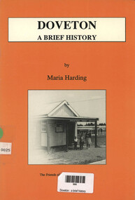
Book, Maria Harding, Doveton : a brief history, 1993
This book includes illustrations, maps, and a bibliography. It provides insights into the development of Doveton, Victoria, and its community spirit. (AI generated)v, 46 p.; 22 cmnon-fictionThis book includes illustrations, maps, and a bibliography. It provides insights into the development of Doveton, Victoria, and its community spirit. (AI generated)doveton (vic.), development -
 Lakes Entrance Historical Society
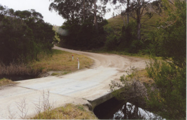
Photograph - Bunga Rd. 2008, Wendy Price, 1/08/2008 12:00:00 AM
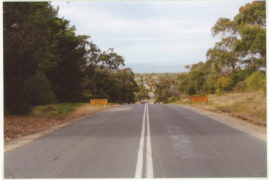
This photograph was used in the 150 year display Lakes Entrance 1858 to 2008 paired with image number 03728 as the after pictureColour photograph of old Bunga Road crossing this was part of the old coach road which went from Lakes Entrance via Lake Tyers to Orbost, Lakes Entrance Victoriaroads and streets, development -
 Lakes Entrance Historical Society
Photograph - Old Bungs Rd. 1927, c1927
This was the old coach road to Orbost which went from Lakes Entrance to Orbost via Lake Tyers.Black and White photograph of old Bunga Road crossing, Lake Tyers.roads and streets, development -
 Lakes Entrance Historical Society
Photograph - Palmers Rd. Lakes Entrance 2008, Wendy Price, 1/08/2008 12:00:00 AM
Colour photograph of Palmers Road looking south overlooking houses and ocean Lakes Entrance Victoriaroads and streets, development -
 Glen Eira City Council History and Heritage Collection
Plaque, commemorative
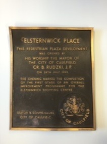
Plaque, bronze, rectangular with polished bronze border and relief lettering and brown textured background. The plaque commemorates the opening of the pedestrian plaza development Elsternwick Place by the Mayor of the City of Caulfield, Cr B. Rudzki J.P. on the 24th of July 1982. The plaque is warped due to installation on a rock, and the reverse has brown and red discolouration and rust.Inscription: Elsternwick Place / This Pedestrian Plaza Development / Was Opened By / His worship the mayor of / The city of Caulfield / CR. B. Rudzki, J. P. / On 24th July 1982. / The opening marked the completion / of the first stage of an overall / Improvement programme for the / Elsternwick shopping centre / Mayor and councillors / City of Caulfield / Arrow Engraving & foundry co. Melb -
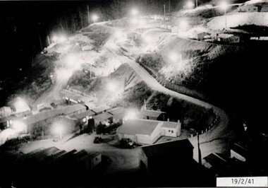
 Falls Creek Historical Society
Photograph - Bogong Alpine Village 1940
The images in the Bogong Village Collection were displayed in Bogong Jack’s Tavern for over 20 years and were donated to the Falls Creek Museum by the Liz Krien & the Bogong Village Trust Board when the Tavern closed in 2021. In 1939, the State Electricity Commission of Victoria established a field headquarters at Bogong to house workers and their families for the Kiewa Hydroelectric Scheme which ran from the 1930s to the 1960s. The workmen's camp was originally started with tents and was called Junction Camp. By 1947, the village supported 300 workers and their families. It included 40 houses, a hostel for single staff, a post office, a police station, a medical centre, and a primary school. The staff hostel was known as Kiewa House. At the completion of the Scheme, in the 1960s, the village was opened to public/tourism use. In 1968 the Victorian Education Department acquired the camp buildings and four houses from the State Electricity Commission of Victoria to establish an Outdoor Education Centre which operated for over 50 years. The Kiewa Hydroelectric Scheme was privatized in the 1990s and sold to Southern Hydro, before being acquired by AGL in 2005. In 2023 the Grollo Group signed a 73 year sublease on Bogong Village and has plans for its redevelopment as a workers’ village.These images are significant because they capture the development of Bogong Village as an important element of the Kiewa Hydroelectric Scheme in Victoria.A collection of 10 black and white images capturing the development of Bogong Alpine Village. They depict development of the new village, the surrounding area and some staff members during 1940.bogong alpine village, bogong 1940, bogong high plains -
 Falls Creek Historical Society
Photograph - Bogong Alpine Village 1941
The images in the Bogong Village Collection were displayed in Bogong Jack’s Tavern for over 20 years and were donated to the Falls Creek Museum when the Tavern closed in 2021. In 1939, the State Electricity Commission of Victoria established a field headquarters at Bogong to house workers and their families for the Kiewa Hydroelectric Scheme which ran from the 1930s to the 1960s. The workmen's camp was originally started with tents and was called Junction Camp. By 1947, the village supported 300 workers and their families. It included 40 houses, a hostel for single staff, a post office, a police station, a medical centre, and a primary school. The staff hostel was known as Kiewa House. At the completion of the Scheme, in the 1960s, the village was opened to public/tourism use. In 1968 the Victorian Education Department acquired the camp buildings and four houses from the State Electricity Commission of Victoria to establish an Outdoor Education Centre which operated for over 50 years. The Kiewa Hydroelectric Scheme was privatized in the 1990s and sold to Southern Hydro, before being acquired by AGL in 2005. In 2023 the Grollo Group signed a 73 year sublease on Bogong Village and has plans for its redevelopment as a workers’ village.These images are significant because they capture the development of Bogong Village as an important element of the Kiewa Hydroelectric Scheme in Victoria.A collection of four black and white images capturing the development of Bogong Alpine Village. They depict development of the new village, the surrounding area and some staff members during 1941.bogong alpine village, bogong high plains, bogong 1941 -
 Port Melbourne Historical & Preservation Society
Document - File, EES submissions, Ewan Ogilvy's Bayside Papers, Box Two: Submissions to Bayside Project Public Inquiry 1987, 1987
Ewan Ogilvy, former Melbourne Councillor and also of Community Services Victoria, Inner Urban Ministerial Advisory Committee and Uniting Church's Centre for Urban Research and Action (CURA), was instrumental in social justice approaches to town planning. He and CURA's Social Justice and the City Project funded Port Melbourne community groups protesting against the SCDC development in 1987. His files were presented to the Society in May 2001 on his preparation for leaving Victoria.From Ewan Ogilvy's chronologically organised 'Bayside Papers' relating to the proposed development of Port Melbourne industrial land in the late 1980s: Bound file of written submissions to the EES Inquiry from the public: EPA, 40ppSigned 'Ewan Ogilvy'; additions to titletown planning, town planning - proposals shelved - bayside, public action campaigns, environmental issues, public housing, missions to seamen, ewan ogilvy, centre for urban research and action, sandridge city development co pty ltd, scdc, terry chumbley, linton r lethlean, peter atkins -
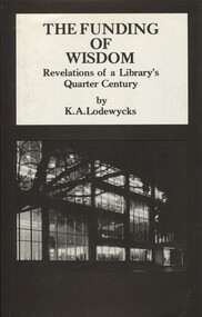 Surrey Hills Historical Society Collection
Book, Spectrum Publications, The Funding of Wisdom: Revelations of a Library's Quarter Century, 1982
The author lived locally. 361p; This book deals principally with experience after the second world war in an environment of tertiary education. It testifies to the unprecedented pressures imposed on such resources by the "information explosion" which accompanied the phenomenal developments in education, science and industry. Title page: signed by the author: Axel Lodewycks Front Endpaper: Book given to me by /Axel as I spoke to him / about his life & home in / Mont Albert and the the Bull / family and Medlow. / 1985 & 1990 / J F Hall361p; This book deals principally with experience after the second world war in an environment of tertiary education. It testifies to the unprecedented pressures imposed on such resources by the "information explosion" which accompanied the phenomenal developments in education, science and industry.Title Page: signed by the author, Axel Lodewyeks. Front end paper: Book given to me by / Axel as I spoke to him / about his life & home in / Mont Albert and the Bull / family and Medlow. / 1985 & 1990 / J F Hall(mr) karel axel lodewycks, university of melbourne - library - history, college librarians - victoria - melbourne, baillieu library, world war- 1939-1945, (mrs) jocelyn f hall -
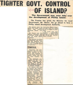 Phillip Island and District Historical Society Inc.
Newspaper Clipping, Tighter Govt. Control of Island?, 31/10/1968
Article from a collection of newspaper clippings from October 1968 to July 1971Article about Government soon to take over the development of Phillip Island. The Minister for Local Government, Mr Hamer, was given the go ahead to form a Phillip Island Development Authority.phillip island, victorian government, mr hamer -
Port Melbourne Historical & Preservation Society
Audio - Oral History, Bayside Development Proposal, Brian Couldrey, 12 Jan 2004
Oral History from Brian Couldrey on Bayside Development Proposal (discussing the proposed Sandridge City development). Recording made by Janet Bolitho on 12.01.2004 Recording duration 32:51built environment, town planning - proposals shelved, brian couldrey -
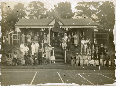 City of Moorabbin Historical Society (Operating the Box Cottage Museum)
Photograph, black & white Cheltenham Tennis Club 1920, and 2 Documents, 1920
Cheltenham Tennis Club was established 1883 when Shire of Moorabbin released land in Cheltenham Park for recreational use. 1924 The Shire of Moorabbin gave permission for the development of extra Courts.Cheltenham Tennis Club 1883 was one of the first Tennis Clubs established in Melbourne.A black and white photograph of men and women seated and standing in and around the Cheltenham Tennis Clubhouse in Cheltenham Park, Cheltenham in 1920. Letter Handwritten 1883 Shire of Moorabbin, South Brighton , release of land in Cheltenham Park for the development of Tennis Courts. Letter Typed 1924 Shire of Moorabbin, permission for extra Courts, signed by the shire secretary, Alexander Chalmers Smith.PHOTO ; written on back : Cheltenham Tennis Club 1920 / Cheltenham Park Letter ; signed John Keys Shire of Moorabbin South Brighton Logo 1871 Letter ; Shire of Moorabbin Logo 1924charman road, cheltenham, 1920, tennis club. charman stephen, gettens mary, spring grove, charman road, balcombe road, nepean road, dairy farmers, market agrdeners, poultry farmers, methodist church, keys john, shire of moorabbin, colsamix, cheltenham park melbourne, sabbath victorian law article 26, cheltenham golf club -
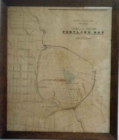 Glenelg Shire Council Cultural Collection
Print - Print - Australia, South coast, Victoria, vicinity of Portland Portland Bay, n.d
Port of Portland Authority archives.Front: (no inscriptions) Back: (no inscriptions)port of portland archives, portland harbour -
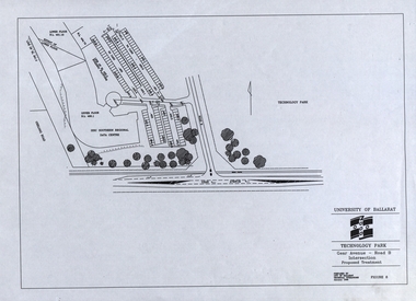 Federation University Historical Collection
Plans, University of Ballarat Technology Park: Developmental Proposal, January 1995
Loose copies of plans for the development of the University of Ballarat Technology Park. -
Federation University Historical Collection
Book, Shipwreck Coast Victoria: Sailing Beyond 2000, c1999
Black plastic binding on a report tourism and development strategy report.shipwreck coast, tourism, tourism strategy, karmen doran, lisa duryea, dean kennedy, vanessa knight, anne maree rundell, port campbell national park, logans beach, warrnamool, heytesbury, vegetation -
Federation University Historical Collection
Book, Environmental/Physical Plan: Little Desert Region, 1996, 1996
Black plastic binding on a report tourism and development strategy report.tourism, tourism strategy, michelle johnson, amanda lockey, belinda page, deborah phelan, emma warhurst, nhill, dimboola, sale, hindmarsh shire council, wimmera river, pink lake, nhill post office, drumbanager homestead, john edward eyre, neilson's cottage, german fest, little desert national park -
Glenelg Shire Council Cultural Collection
Photograph - Photograph - Portland Harbour development, n.d
Port of Portland Authority ArchivesBack: Sticker, with 'ARTISTS IMPRESSION' that doesn't quite fit? - black biroport of portland archives, port development -
Glenelg Shire Council Cultural Collection
Photograph - Photograph - Portland Harbour Development Illustration, n.d
Port of Portland Authority ArchivesBack: White sticker - 'PORTLAND HARBOUR TRUST' E.C.P. Hughes Scheme -black biroport of portland archives, portland harbour -
Whitehorse Historical Society Inc.
Article, Tally Ho Answers The Call, c1970
Article tracing the development of Tally Ho Training Farm. With photos.Article tracing the development of Tally Ho Training Farm. With photos.Article tracing the development of Tally Ho Training Farm. With photos.welfare services, central methodist mission, tally ho boys home, cole, george henry, hoadley, abel, rising sun jams, australian jam company, derrick, edgar m., cox, ian, godbehere, albert, oakley, dennis, rev, adams, bill, hinneberg, ernest -
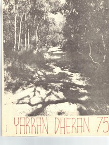 Whitehorse Historical Society Inc.
Document, Yarran Dheran, 1/06/1975 12:00:00 AM
Report on Yarran Dheran in 1975. Includes history of developments and photographs.parks and reserves, yarran dheran, thompson, paul, addie, john -
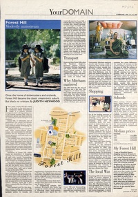 Whitehorse Historical Society Inc.
Newspaper - Article, Forest Hill: Modestly mainstream, 3/02/1999
Brief history of the development of Forest Hill and facilities available to residents.residential development, hall, noel, canterbury road, forest hill, burwood highway, vermont south, forest hill -
 Whitehorse Historical Society Inc.
Document, Passive Parkland : Committees of Management, 1982
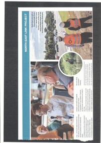
Passive Parkland Committees of Management: a report on their formation and development, 1982parks and reserves, city of nunawading, brandenburg, john p, schwerkolt cottage, blackburn lake sanctuary, yarran dheran, wandinong sanctuary, bellbird dell, r.e. gray reserve, cootamundra walk -
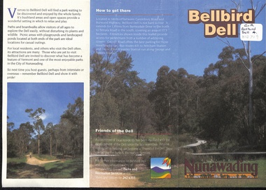 Whitehorse Historical Society Inc.
Pamphlet, Bellbird Dell, n.d
History and development of Bellbird Dell. Includes colour photos and map.parks and reserves, city of nunawading, morack road, vermont south, george road, philip street, vermont, bellbird dell -
 Melton City Libraries
Souvenir, City of Melton stickers, Unknown
Melton Promotion and Development Group Stickers promoting the City of Meltoncouncil -
Camberwell Historical Society
Document (Item) - Report, City of Boroondara, City of Boroondara Annual Report 1996, 1996
boroondara -
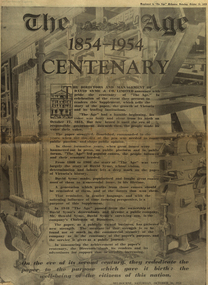 Federation University Historical Collection
Newspaper, The Age - Centenary, 16/10/1954
54 pages The Age centenary 1854 - 1954 Victoria's agricultural development Australian manufacturing Melbourne Universitythe age, centenary, victoria, agriculture, manufacturing, melbourne university, david syme, oswald syme -
 Whitehorse Historical Society Inc.
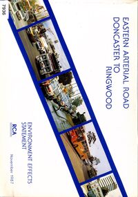
Book - Government Environment Effects Statement, Road Construction Authority (now part of VicRoads), Eastern Arterial Road - Doncaster to Ringwood, November 1987
The book covers the Environment Effects Statement for the Eastern Arterial Road Extension from Doncaster to Ringwood and the Ringwood Bypass. Aspects covered are development works, traffic affects, public transport, landscape and visual affects, noise, pedestrian/ bicycle access, lighting, air quality and construction affects. Includes maps, cross sections, photos.The book covers the Environment Effects Statement for the Eastern Arterial Road Extension from Doncaster to Ringwood and the Ringwood Bypass. Aspects covered are development works, traffic affects, public transport, landscape and visual affects, noise, pedestrian/ bicycle access, lighting, air quality and construction affects. Includes maps, cross sections, photos.non-fictionThe book covers the Environment Effects Statement for the Eastern Arterial Road Extension from Doncaster to Ringwood and the Ringwood Bypass. Aspects covered are development works, traffic affects, public transport, landscape and visual affects, noise, pedestrian/ bicycle access, lighting, air quality and construction affects. Includes maps, cross sections, photos.eastern freeway extension, eastern arterial road, mullum mullum creek, road construction, environmental impact -
City of Kingston
Photograph - Colour, 31 January 1993
Patterson Lakes is a suburb in the City of Kingston that is built one kilometre upstream of the mouth of the Patterson River. The area is bordered by the Patterson River and Eel Race Drain which enters the Kananook Creek. The suburb consists predominantly of newer housing developments and the tidal canal system of the development joins Port Phillip Bay. Patterson Lakes and the Kananook Creek were previously part of the extensive Carrum Carrum Swamp. The area was once a source of fish and eels for the Mayone-Bulluk clan of the Bunurong people. Over time the area was drained and in 1973 investigations commenced into the development of a unique residential area that would be built adjacent to canals and waterways. It was originally proposed to be known as "Gladesville". The development would give the suburb's homeowners access to Port Phillip Bay "from their back door". Circa 1974, the area was rezoned from rural to residential and named Patterson Lakes. Development has been continuous since the 1970s with construction of residential housing, schools, shopping centres, marinas, a hotel and library.Laminated colour aerial photograph of the Carrum and Patterson Lakes region within City of Kingston. This 1993 image includes Patterson River Secondary College, Roy Dore Reserve, Kananook Creek and Nepean Highway. The railway line can be seen as it veers inland from Eel Race Road, Seaford. The section of Ocean Reef Drive and Palm Beach Drive in Patterson Lakes appears to be a recent development with many spare blocks and new houses under construction.Black typed lettering on white adhesive label: 31.1.93 Black typed lettering on white adhesive label: 27E/7140 31/1/93 12.55 pm Black typed lettering on white label: 7140 Yellow round adhesive label located on left sidepatterson lakes, seaford, kananook creek, carrum carrum swamp, canals and waterways