Showing 10962 items matching " plan"
-
 Surrey Hills Historical Society Collection
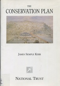
Book, The Conservation Plan: a guide to the preparation of conservation plans for places of European Cultural Significance, 1996
This guide is about gathering, analysing and assessing information that bears upon policy decisions and on the process of making those decisions. It offers a common ground for debate, a method and a common language to help resolve differences and achieve a balance between the old and the new. The result of these processes is a conservation plan.historic sites - australia - conservation and restoration, historic buildings - conservation and restoration - ausation of places of cultural significancetralia, monuments - australia - conservation and restoration, australia/icomos charter for the conserv -
 Orbost & District Historical Society
folder, 1962-1968
Orbost Aero Club began in 1969 with Basil Dowie as Chair, David Nixon as Secretary/Treasurer. The group went into recess from 1977-1991 closing in 1997. The mid 1960s were boom years in flying training in Australia and the number of Aero Clubs grew rapidly. The Club played a significant role in the establishment of the small airport at Marlo and in the ongoing operation and development of the airport over the years particularly for patient transfer by aerial ambulance. The Orbost Aero Club Club played a significant role in the establishment of the small airport at Marlo and in the ongoing operation and development of the airport over the years. A manila folder containing plans for Marlo Aerodrome.On label on front - MARLO/ORBOST AERODROME PLANSorbost-aero-club marlo-airport -
 Melbourne Tram Museum
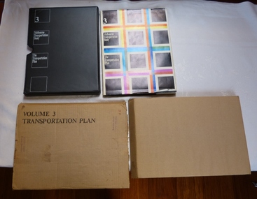
Document - Report, The Metropolitan Transportation Committee, "Melbourne Transportation Study - The Transportation Plan - Volume 3", 1969
Report titled "Melbourne Transportation Study - The Transportation Plan - Volume 3", presented in a black vinyl covered slip case, paper cover, bound, sewn with end papers, fold out maps, 74 pages. Each sheet within the report has rounded edges. Contained within a printed cardboard packing case. Includes many tables, graphs, charts and coloured sheets. Report prepared by The Metropolitan Transportation Committee - 1969, looking at the planning of all forms of transport for Melbourne with a timeframe of 1985. Chaired by Vernon Wilcox, Minister of Transport. Included Robert Risson - Chairman of MMTB. Set the basis for a very extensive freeway system that was only partly followed. Includes trams, trains (city loop), buses, parking, travel and population predictions, costs and implementation.Has numerous AETA stamps throughout the book. Inside front cover and on packing case "A12" in red ink.trams, tramways, melbourne, road transport, tramways, railways, public transport, transportation plan -
 Ballarat Tramway Museum
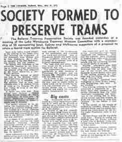
Newspaper, The Courier Ballarat, "Society formed to Preserve Trams", "Three stage plan for phasing out of trams", 14/07/1971 12:00:00 AM
Yields information about the formation of the BTPS in 1971 and some of the people who attended meetings etc. and about the closure of the Ballarat tramway system.Two Newspaper clippings pasted onto a single sheet of paper with two Punch holes on the left hand side. First clipping from The Courier, Ballarat, Monday, 31/5/1971, titled "Society formed to Preserve Trams" (newspaper date, with page 2), about the formation the previous day of the BTPS at a meeting of the Lake Wendouree Tramway Museum Committee with a membership of 55 people to retain a tourist tram system for Ballarat. Gives names of the elected office bearer, details of proposals, some costs, alternative sites and that a tram was chartered before the meeting. 1071.1 - photocopy of the article added 24/1/2008. Has the names of those elected highlighted in pink ink. Second cutting dated "14/7/71" from the Courier titled "Three stage plan for phasing out of trams" of the three stage plan for phasing out of the trams in Ballarat. The plan was announced by Transport Regulation Board the previous day. August 23 - Drummond St North and Victoria St., Sept. 6 for Gardens via Sturt St and Mt Pleasant and Sept 20 for Lydiard St. North and Sebastopol. 1071.2 - as above, original clipping, donated by Dave Macartney, added 10/9/2013In red ink in upper right hand corner of second cutting, "14/7/71" Has numerous pencil and pen marking from previous use, possibly at Ronaldson and Tippet where the donor worked.trams, tramways, closure, bus changeover, transport regulation board, tram services, btps -
 Tatura Irrigation & Wartime Camps Museum
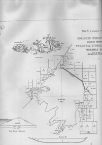
Plan, Waranga Basin Project, c.1890
Original plan held at Tatura Office og Murray Goulburn Water, electronically copied.waranga basin, irrigation, agriculture, rural, industry -
 Melbourne Tram Museum
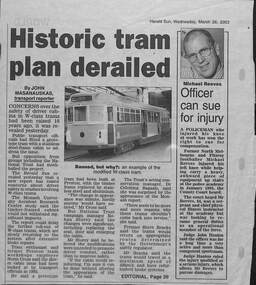
Newspaper, Herald Sun, "Historic tram plan derailed", 1/4/1992
Report titled "Historic tram plan derailed", concerning a report by Monash University Accident Research Centre about the crashworthiness of the W class trams. Notes issues with the timber framed cabins, National Trust, and others. Quotes Norm Cross about the 1993 proposal with a photo of the tram that was to be the prototype. Yields information about the investigation into the crash worthiness of the W class tram and Monash University report.Newspaper clipping from Herald Sun 26/3/2003.tramways, w8 class, preston workshops, w class, accidents, national trust, monash university -
 Federation University Historical Collection
Plan, Scarsdale County of Grenville, 1889, 26/01/1889
Rectangular plan of a geological survey edged in masking tape. It is predominantly grey, pink and green, but has some yellow. scale is 40 chains to one inch. (see Cat. No. 1098 for report on the Parish of Scarsdale)scarsdale, grenville, krause, browns and scarsdale, mopianimum, watershed, yarrowee, woady yalloak, timber reserve, department of mines, plans, cgt, crown lands, ferdinand krause -
 Glenelg Shire Council Cultural Collection
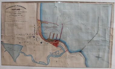
Work on paper - Drawing No. 2, Plan Shewing Works Recommended by Sir John Coode, 1879
Drawing of Portland Bay showing the proposed harbour. Portland town centre is shown as it Portland Botanic Gardens and Battery Hill.Top left: Victorian Harbours / Portland / Plan Shewing Works Recommended by / Sir John Coode / in his report dated Dec r 1879 / The proposed works shown by red colour / the extensions to be undertaken in the first instance across by red colour / subsequent extensions and reclamations are coloured brown Top Right: Drawing No. 2 Portland Borough Council stamped top leftportland harbour, sir john coode, portland, plans, drawings, 1800s -
 Eltham District Historical Society Inc
Document - Report, Paul Jerome, Advisory Committee on a Proposed Convenience Centre and an Alternative Shire Proposal - Eltham Gateway Community Precinct Concept Plan - 895 Main Road Eltham, October 1997
On 15 December 1994 the former Shire of Eltham ceased to exist following the Liberal Kennett Government local council amalgamations. A new Nillumbik Shire Council was established with unelected commissioners appointed. That Council sold the former Eltham Shire Council Offices and land at 89S Main Road Eltham to Dallas Price Homes Pty. Ltd. the sale being conditional upon the granting of a planning permit for a petrol station/convenience store, fast food and video outlet. The sale was conditional that if the permit was not granted by 30 August. 1997, the contract could be avoided by either the purchaser or the vendor. The proposed development consisted of a petrol station with undercover fuelling facilities, convenience shopping, a drive through service facility for fast food, an 80 seat cafe, automated banking, a children's play area and retail space. In addition, the proposal included a 200 square metre community facility for Council use, provision of on site carparking over 2 levels for 83 vehicles, and advertising signage. An Advisory Committee consisting of Dimitry Reed and Margaret Pitt was appointed under Section 151 of the Planning and Environment Act 1987 to hear submissions on the proposal to develop the land at 895 Main Road Eltham, the site of the former Eltham Shire Offices. In September 1996, two applications were made by Contour Consultants Australia Pty Ltd on behalf of Dallas Price Homes Ply Ltd, to Nillumbik Shire Council. After extensive notification, the Council received 213 objections and a petition of over 1400 signatures. On October 9, 1996, Nillumbik Shire Council issued Notices of Decision to Grant Permit on Applications number 96/03376 and 96/0377 for the use and development of the land as a convenience Centre consisting of a petrol station, convenience store, cafe/takeaway food premises, a retail facility and a community facility, with associated advertising signs. Objectors to the proposals lodged Planning Appeals number 96/40724 and 96/40812 with the Administrative Appeals Tribunal on November 1, 1996. The grounds of appeal can be summarised as: inappropriate development, insufficient carparking, traffic and access issues, unsatisfactory design, inadequate permit conditions, the proposal being out of character with the area. and being contrary to the purpose and orderly development of the Eltham Town Centre, excessive noise, lack of consultation and unsuitable signage. On November 13, 1996, the Minister for Planning and Local Government directed the Registrar of the Administrative Appeals Tribunal. under Section 41 (1) (a) of the Planning Act 1980, to refer the Appeals to the Governor in Council for determination without a hearing or recommendation by the Tribunal. The Minister for Planning and Local Government called in the Appeals as he considered that they raised major issues of policy relating to the facilitation of development in accordance with the objectives set out in Section 4 of the Planning and Environment Act 1987, and that determination of the Appeals could have a substantial effect on the achievement of these planning objectives. The Minister required the Advisory Committee to consider the planning merits of the proposed use and development, and to address the issues raised in the objections. The Advisory Committee was required to produce a report providing: • The Committee's response to the matters detailed; • Relevant supporting information for the Advisory Committee's recommendation; and • A description of the proceedings conducted by the Advisory Committee and a list of those consulted or heard by the Committee. In March 1997, elections were held in the Shire of Nillumbik and the view of the new Council to this proposal differed from the view held by the earlier Council Hence the Submission made to the Committee by the Shire was against the decision by the Shire of Nillumbik to issue the Notices of Decision to Grant a Permit. The Recommendations of the Advisory Committee were: i. The cafe and take away food premises are as of right uses and are therefore allowable, but that shop and petrol station are unacceptable uses. A community facility is a discretionary use and is acceptable. ii. A development of the type and scale proposed is totally inappropriate for this land and that the Applications number 96/03376 and 96/0377 for the use and development of the land as a convenience Centre consisting of a petrol station, convenience store, café/takeaway food premises, a retail facility and a community facility, with associated advertising signs, be refused. iii. The land should be rezoned for public purposes and should remain in the community's ownership for community use. Following this, the Minister for Planning and Local Government, the Hon. Robert Maclellan, appointed Mr. Paul Jerome as an Advisory Committee under section 151 of the Planning and Environment Act 1987 to consider a Convenience Centre and an alternative proposal by Iha Shire of Nillumbik being the Eltham Gateway Community Precinct Concept Plan for the site of the former Shire of Eltham municipal offices at 895 Main Road, Eltham. In summary, the terms of reference for the Advisory Committee required it to: • consider the merits of the Council proposal • examine the merits of both proposals in terms of net community benefit • address the report of the previous Advisory Committee on the Convenience Centre proposal The Advisory Committee inspected the site and considered all the material before It including submissions made by all parties to the previous Advisory Committee and correspondence received by the Department of Infrastructure both before and after that Committee submltted its report. The Advisory Committee also held discussions with the following people: • Cr. Robert Marshall • Cr. Margaret Jennings • Cr. Lex de Man • Mr. Dallas Howgate of Dallas Price Properties, also Dallas Price Homes • Mr. Barry Rochford, CEO, Shire of Nillumbik • Ms. Yvonne Rust, Planning Officer, Shire of Nillumbik • Mr. Gregory Burgess, Architect of the Eltham Library and of Council’s Community Precinct Concept Plan • Mr. Jim Connor representing Mrs Thelma Barkway of the Eltham Senior Citizens Club Having considered all the material before it, the Committee arrived at two basic conclusions. First, the DPP proposal should be rejected because, on its merits, It does not sufficiently satisfy the requirements of the planning scheme which is a statutory document. The planning scheme requires that, before making a decision on the permit applications for the DPP proposal, a range of matters must be considered. It follows that consideration of these matters should Influence the decision. These matters include local policies relating to character and amenity. In particular, these policies seek • to conserve and enhance the bushland/country atmosphere, artistic heritage and strong sense of community of the Eltham Town Centre by ensuring that the design and height of any new development is sympathetic to existing buildings • to achieve a pleasing physical environment within the Eltham Town Centre by encouraging a high standard of architecture and urban design • to encourage Improvement to pedestrian amenity through such facilities as open and shattered rest areas and meeting places, crossing facilities, pedestrian arcades, pedestrian links to car parks and pedestrian weather protection • to reduce conflict between vehicular traffic and pedestrian flows, and • to encourage pedestrian thoroughfares It is submitted, as set out In the main body of this report, that the DPP proposal fails substantially to meet these policies and In so doing does not merit the exercise of discretion In Its favour with the Issuing of a permit. This finding is not offset by the investment and employment attributes of the proposal. They do not override the need to comply with the planning scheme. Second, the Council proposal, on Its own merits, substantially meets all statutory requirements applicable to this site with a possible reservation about car parking and traffic management which need further definition and assessment as the concept is refined. The Council proposal, however, has a serious weakness in that Its financial viability has not been adequately tested. The Committee refers to 'financial' rather than 'commercial' viability in recognition that Council owns the land and may enter into a range of agreements and partnerships to realise its concept some of which may be truly commercial and some of which may involve an element of subsidy arising from Council's involvement as a public body acting on behalf of its community. The Committee concludes that Council should be given the opportunity, within a reasonable timeframe to establish the financial feasibility of its concept and should develop a strategy for the future of Its land asset at 895 Main Road in the event that Its concept for the site cannot be realised. 895 main road, advisory committee, dallas price homes, eltham, eltham shire office, nillumbik shire council, planning application, administrative appeals tribunal -
 Orbost & District Historical Society
plans, Elliott Engineering Company Pty Ltd, 1980
These plans were used by POW Sawmills, Newmerella, probably owned at the time by Henry's Timber Company. Hec Pow and his father sold the Newmerella mill to Henry Silverberg and Les Grace. The mill is currently owned by Mectec.Orbost has historically been based on the timber industry, but that industry has declined considerably over the last 20 years. The number of locals involved in the timber industry has declined and many of the mills have closed. This item reflects a time when that industry was a significant contributor to the economy of the district.Eight large plans for various sections of POW's at Newmerella. The plans were drawn up for Bonang Timbers and Bowman.2317.2 - on back in pen "REC 24/9/80" 2317.3 - on back in red pen "INCOMPLETE SET OF PLANS" ; sticker with "Shire of Orbost Compulsory Inspection" 2317.5 - "DODD" in red ink (John H. Dodd Pty Ltd) -
 Orbost & District Historical Society
plan, before 1948
Drainage infrastructure was developed and maintained in this region by the Snowy River Improvement Trust. The Trust was administered by a local committee and its activities funded by a local rate charged on the farmers and land owners in the Trust’s designated district. The level of the rate charged by the Trust was designed to be proportionate to the benefit derived from the works undertaken. Financial assistance was provided by the State Government from time to time for specific projects such as post flood repairs but not for new capital works. The Trust undertook new drainage and river management works including tree planting, rock beach construction and servicing of the drains and flood gates. The Trust also provided a personal flood warning service to the farmers in its district. The Trust ceased to operate in 1997 with the advent of the East Gippsland Catchment Management Authority. The infrastructure developed by the Trust continues to provide a service to the farmers in the region. (ref. 4 East Gippsland CMA Submission to Inquiry into Flood Mitigation Infrastructure in Victoria) This plan is significant as a historical document. The Snowy River Improvement Trust was vital to the Orbost district because of its ability to apply local knowledge and to engage the local farming community.A large plan of divisions of land for the purpose of levying the Snowy River Improvement District - Bete Bolong, Orbost, Waygara, Newmerella and Orbost East. The properties are coloured according to levy amount. The scale is 1" - 20 chains. snowy-river-improvement-trust -
 Ballarat Tramway Museum
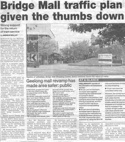
Newspaper, The Courier Ballarat, "Bridge Mall traffic plan given the thumbs down", 8/06/2002 12:00:00 AM
Newspaper cutting from the Courier 8/6/2002, titled "Bridge Mall traffic plan given the thumbs down" written by Andrew Molloy about the general opposition to opening Bridge St. Mall to traffic, but that there was strong support for the return of a tram service. Has a photo of the Mall taken from Grenville St. Article also has notes regarding the Geelong Mall.bridge st, mall, tram revival -
 Melbourne Tram Museum
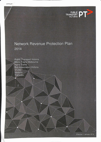
Book, Public Transport Victoria (PTV), "Network Revenue Protection Plan - 2014", 2013
Report - 16 A4 sheets, colour, stapled in the top left hand corner, titled "Network Revenue Protection Plan - 2014", prepared by the PTV for the various transport operators in Victoria. Has a table of Contents, introduction, background and context, Fare Evasion behaviour, management of evasion, monitoring, key revenue protection areas and actions to be delivered. Only the first two pages scanned.trams, tramways, tickets, fares, ptv, behaviour, public transport -
 Lakes Entrance Historical Society
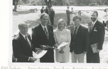
Photograph, Lakes Post Newspaper, Victorian Coastal strategy draft plan for Eastern Beach Lakes Entrance Victoria, 1/12/1996 12:00:00 AM
Black and white photograph of Robert Fordham,Chairman Vic Coastal Council, Duncan Malcolm, Diane James Acting Chairman Vic Coastal Council, Philip Davis Gippsland Province MLC, Fred Herbert Gippsland Coastal Council taken during launch of Victorian Coastal strategy draft plan for Eastern Beach taken in Lions Park Lakes Entrance Victoriacoast, environment, volunteering -
 Tatura Irrigation & Wartime Camps Museum
Map, Part Murchison North Parish Plan
Ownership detail obtained from S.R. & W.S.C. rate book 1933. Part Murchison North Parish Plan with extent of "Kiota" property outlined, as in 1933, owned by Gerald N. Buckley, purchased in 1936 by Pargeter, and held until 1943. Note that Kiota Road west of the Tatura Murchison Road was unfenced in those years.kiota estate, pargester,buckley, dhurringile. -
 Falls Creek Historical Society
Plan - Diagram of Turnstile for New Chairlift
Bob (Herman) Hymans (a former member of the Royal Netherlands Navy was born in Bloemendaal, Holland on 30th September 1922. During World War II he fought against the Japanese in the Dutch East Indies (now Indonesia) and was imprisoned in Changi and on the Burma Railway. After gaining qualifications as a Ski Instructor, Bob arrived in Falls Creek in May 1950. Working as an Instructor and Supervisor at Bogong Lodge, Bob decided his future was in accommodation. He was successful in negotiating an indenture for land from the State Electricity Commission (SEC). It took Bob two years to build his Grande Coeur Chalet but, tragically, it was burned down in August 1961. Bob also built the first Chairlift in Australia. This was a single chairlift and the structure was built from wooden electricity poles. He was constantly full of new ideas and proposals for the village. Bob Hymans died on 7th May 2007. This Collection of documents and letters tells the story of Bob’s endeavours to develop Falls Creek into the ski village it is today. This map is significant because it documents plans made by Bob Hymans for Falls CreekThis diagram is part of Bob Hymans documents. It is a detailed plan, including elevation, detail of pivot and the general arrangement views of a turnstile. This is part of overall plans for the construction of a new chairlift at Falls Creek. At bottom of diagrams: PLAN TURNSTILE/ GENERAL ARRANGEMENT Scale 1 1/2" = 1'- 0"map of falls creek, falls creek leases, falls creek 1980s -
 Hymettus Cottage & Garden Ballarat
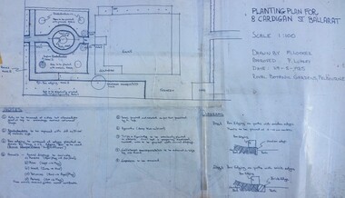
Photograph - landscape design plan, Planting Plan for 8 Cardigan St Ballarat, 1985
Michael Looker of the Royal Botanical Gardens Melbourne drew up the planting plans for restoring Ballarat's historic gardens at Hymettus in 1985 for Heritage Victoria. This was done as it was the only known intact Victorian era working-mans exhibition garden in Australia with surviving layout and original documentation and photographs. Restoration of the garden was aided by an Australian Bicentenary grant.Plans for the restoration of Hymettus' front flower garden using old photographs of its exhibition gardens first opened to the public in 1917 and drawn up by the Melbourne Royal Botanic Gardens for Australia's Bi-centenary 1988.historic gardens, ballarat, hymettus, royal botanical gardens, melbourne, lumley, looker, heritage victoria, exhibition garden. -
 Melbourne Tram Museum
Document - Digital Image, Victorian Transport Action Group (VTAG), "Melbourne’s Tram Plan Response Filling the Gaps", March 2024
Document produced by the Victorian Transport Action Group as a response to the Department of Transport "Melbourne Tram Plan" of Oct. 2023 - see item 7364. VTAG have produced a number of initiatives and looks at a number of route proposals that have been made by Government but as of the end of 2024, little progress has been made on any of them. Initiatives suggested are: 1. Confirm its commitment to previously announced projects (listed in Table 1) and provide indicative timeframes for completion. 2. Redirect routes 3, 5 and 12 (detailed in Table 2) with the opening of MM1 to improve the distribution of tram services through the central area. 3. Direct Infrastructure Victoria to undertake the specific planning process as part of the next state infrastructure plan to canvas a range of possible network enhancements. 4. Revise the selection of stops for upgrade to level access to include the practical considerations of technical feasibility and constructability to ensure that as many stops as possible are delivered as a priority. 5. Expand the corridor-based approach being applied to upgrade stops to include the implementation of traffic priority along the selected corridors. 6. Adopt a 15mins, or at least 20 mins, as the maximum headway for all Melbourne tram routes. Notes changes that will be needed as a result of the Melbourne Metro in 2025, tram stops, energy efficiency, renewing the fleet and infrastructure, network performance, and passenger experience. Demonstrates a response to the Vic Govt's tram plan by an Action Group.Digital copy of a 21 A4 page document produced by the Victorian Transport Action Group March 2024. tramways, victorian government, department of transport, planning, vtag -
University of Melbourne, Burnley Campus Archives
Administrative record - Report, The University of Melbourne, Faculty of Land and Food Resources, The Burnley Master Plan, 2007
finance, buildings -
 Melbourne Tram Museum
Pamphlet, P. Thomas, South Melbourne Depot, "Cross City Linking - A plan for the future or another PTC Fiasco????", c1992
Pamphlet, letter or notice - photocopy onto an A4 sheet, both sides, titled "Cross City Linking - A plan for the future or another PTC Fiasco????", looking at the proposed project , relationships with the Public Transport Users Association (PTUA), route changes, union actions, impacts of proposals and asking members to be involved in the proposal at South Melbourne Depot - c1992 See Reg Item 1535 for a report on this project.trams, tramways, the met, unions, south melbourne depot, management, ptc, routes, w class, operations, buses, ptua -
 Melbourne Tram Museum
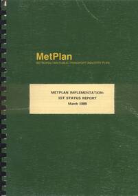
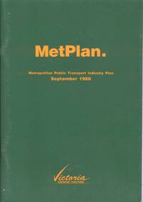
Document - Report, Metropolitan Transit Authority (MTA), "Metplan Metropolitan Public Transport Industry Plan - Metplan Implementation - 1st Status Report, Mar. 1989
Report - approx. 100 pages - un-numbered, A4, black comb binder with green covers titled "Metplan Metropolitan Public Transport Industry Plan - Metplan Implementation - 1st Status Report - March 1989." Report looks at the implementation of Metplan (See Regg Item 348). Produced by the Metropolitan Transit Authority. Does not have an index, does provide a large list of projects.trams, tramways, transport, light rail, tramways, railways, road transport, minister for transport, mta -
 Kew Historical Society Inc
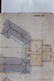
Slide - Architectural Drawing, Kew Public Offices, 1887
A civic campaign for new public offices developed in Kew in the 1880s. After much deliberation, the location chosen was the junction of Bulleen and Cotham Roads. The buildings were designed by George Watson and John Henry Harvey, architects within the Department of Public Works (Victoria). Building was commenced in 1887, and after one year, the buildings were opened. The Post Office was transferred to the new Commonwealth Government in 1901. The Police Station and Court House, sold by the Victorian Government to the City of Boroondara in 2007, are now a community cultural centre and performing arts venue.The buildings were listed on the Victorian Heritage Register Register (HO885) in 1991. They are historically and architecturally significant to the State Of Victoria because Watson and Harvey's designs exhibit diversity in integrating civil offices, they accommodate the apex of road junctions, and they demonstrate a departure from the contemporaneously favoured High Victorian Classical to the Queen Anne style in the design of civic buildings. 35mm colour transparency of an original plan by George Watson and John Henry Harvey, architects of the Department of Public Works (Victoria), in 1887 for New Public Offices at Kew. This plan was copied by the donor from an original held at the Commonwealth Archives in Brighton (Vic). The copy was made to illustrate a report that the donor made on ‘The functional planning design, building materials and construction methods of the Kew Post Office’ as part of course work at RMIT.DRAWING NO 1 / ROOF PLANkew court house, kew police station, kew post office, architectural drawings, khs - slides, new public offices -- kew (vic.), architecture — queen anne style -
 Greensborough Historical Society
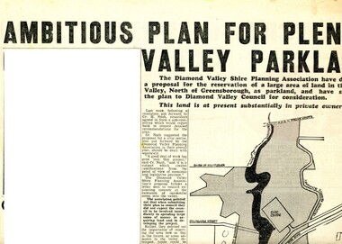
Newspaper Clipping - Digital Image, Ambitious plan for Plenty Valley Parklands 1965, 05/11/1965
In 1965, the Diamond Valley Shire planning association recommended to Council that a large area of land north of Greensborough be acquired for Parkland. The idea of a Civic Centre was included with a map of the area from Grimshaw Street in the south to the MMBW pipeline reserve in the north. Includes a suggested new site for the local school, near Yando Street. This area is now part of the Plenty River Trail.An example of developments in the Greensborough area during the period of Shire of Diamond ValleyNews clipping, black and white text and map. Scanned in 3 parts.shire of diamond valley, civic drive greensborough, yando street greensborough, partingtons flat, plenty river trail -
 Ballarat Tramway Museum
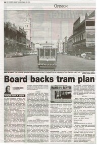
Newspaper, The Courier Ballarat, "Board back tram plan", 29/08/2002 12:00:00 AM
Yields information about the view of the Executive Director of Ballarat Tourism about the proposal for a Ballarat Tourist based tramway in 2002.Newspaper clipping from the Courier, Thursday 29 August 2002, titled "Board back tram plan" about the Ballarat Tourism Board supporting the construction of tourist based tramway in Ballarat, written by the Executive Director of Ballarat Tourism. Features a digital image of BTM tram 13 in Lydiard St North with the Post Office and George Hotel in the background. Gives information about the benefits of the proposal for Ballarat. ballarat revival, btm, lydiard st north, city tramway -
 Kew Historical Society Inc
Plan, Studley Heights Estate, 1936
Pru Sanderson, in her groundbreaking ‘City of Kew Urban Conservation Study : Volume 2 - Development History’ (1988), summarised the periods of urban development and subdivisions of land in Kew. The periods that she identified included 1845-1880, 1880-1893, 1893-1921, 1921-1933, 1933-1943, and Post-War Development. These periods were selected as they represented periods of rapid growth or decline in urban development. An obvious starting point for Sanderson’s groupings involved population growth and the associated economic cycles. These cycles also highlighted urban expansion onto land that was predominantly rural, although in other cases it represented the decline and breakup of large estates. A number of the plans in the Kew Historical Society’s collection can also be found in other collections, such as those of the State Library of Victoria and the Boroondara Library Service. A number are however unique to the collection.Subdivision plans are historically important documents used as evidence of the growth of suburbs in Australia. They frequently provide information about when the land was sold on which a built structure was subsequently constructed as well as evidence relating to surveyors and real estate and financial agents. The numerous subdivision plans in the Kew Historical Society's collection represent working documents, ranging from the initial sketches made in planning a subdivision to printed plans on which auctioneers or agents listed the prices for which individual lots were sold. In a number of cases, the reverse of a subdivision plan in the collection includes a photograph of a house that was also for sale by the agent. These photographs provide significant heritage information relating house design and decoration, fencing and household gardens.The ‘Studley Heights Estate’ on the South Side of Studley Park Road was launched in 1936. The seventeen allotments in the subdivision fronted Hyton Crescent and Studley Park Road.subdivision plans - kew, studley heights estate -
 Ringwood and District Historical Society
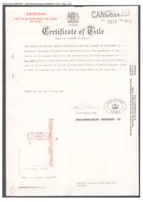
Document, Certificate of Title 1977 and Subdivision Plan 1999 - 21-23 Bemboka Road Warranwood, Victoria
A4 copies of Landata Victoria Historical Search documents. Certificate of Title Vol 9217 Fol 041 Church of England Trusts Corporation For The Diocese Of Melbourne - part of Crown Section 20, Parish of Warrandyte, County of Evelyn, 7th June, 1977. Includes Plan of Subdivision , postal address Bemboka Road, Warranwood 3134 (north of Lyric Court), certified under Subdivision Act 1988, 8/2/1999. -
 Melbourne Tram Museum
Drawing, "Plan of Survey of Part of Crown Allotments 15 and 16 at Hawthorn, Parish of Boroondara, County of Bourke", 1922
Drawing, coloured with water based drawing wash, titled "Plan of Survey of Part of Crown Allotments 15 and 16 at Hawthorn, Parish of Boroondara, County of Bourke". Shows the tram track, Wallen Road, changes around the intersection with Power St, buildings. A note at the bottom notes who owns what - MMTB and City of Hawthorn. Prepared by H. S. McComb, licensed Surveyor 6-9-1922. Stored folded.Stamped "Drawing Office" "Office Copy" and in red pencil "Hawthorn" in the bottom right hand corner, and on the rear "Drawing Office" "Office Copy" and "Hawthorn Depot" in pencil.trams, tramways, htt, mmtb, hawthorn depot, plans -
 Melbourne Tram Museum
Document - Report, Metropolitan Transit Authority (MTA), "Metplan Metropolitan Public Transport Industry Plan - September 1988", May. 1988
Report - 64 pages, green card cover, centre stapled titled "Metplan Metropolitan Public Transport Industry Plan - September 1988", looking at Melbourne's transport needs over the next 15 years. Produced by the MTA, signed off by Jim Kennan Minister for Transport . Has an index, looks at the Task, heavy, light rail, tram, bus, taxis, ticketing systems, management, and the various regions including funding and budget.trams, tramways, transport, light rail, tramways, railways, road transport, minister for transport, mta, metplan -
 Ringwood and District Historical Society
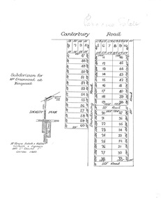
Plan, Paradise Estate Subdivision, Ringwood, Victoria - circa 1925
Paradise Estate layout also included in Land Sale Brochure Titled Eureka Plan Book - Seven Delightful & Valuable Ringwood Estates - circa 1925, Reg. No. 5100.Subdivision plan of Paradise Estate, Ringwood, showing allotments for sale, with typed page attached showing block sizes and prices.Locality plan showing land for sale south of Canterbury Road, 1 Mile south of Ringwood Railway Station. Subdivison includes Canterbury Road and Dandenong Road (later Wantirna Road). Surveyors - McKenzie Aisbett & Webber, surveyors & engineers, 440 Little Collins Street, Melbourne, Telephone Central 11540. Subdivision for Mr Grenwood at Ringwood. Additional typewritten price list showing footage, price per foot, and price per block for Lots No. 1 to 60. Paradise Estate layout also included in Land Sale Brochure Titled Eureka Plan Book - Seven Delightful & Valuable Ringwood Estates - circa 1925, Reg. No. 5100. -
 Federation University Historical Collection
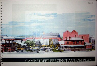
Booklet, Camp Street Precinct Action Plan, 10/1998
The camp Street Action Plan aimed to create a vibrant focus of community life, arts and culture in the heart of Ballarat. It included the relocation of the University of Ballarat Visual and Performing Arts from Mt Helen to the Camp Street precinct. Key sits were the Ballarat Post Office, former Ballarat Library, Victorian Business Centre, Police stations, Ballarat fine Art Gallery, field Street Car Parks. Rring bound booklet with clear plastic cover.arts academy, camp street precinct, alfred deakin place, former ballarat mining exchange, mining museum, art gallery of ballarat