Showing 7614 items matching " road development"
-
 Greensborough Historical Society
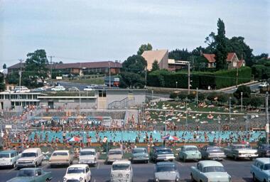
Photograph - Digital Image, R. Max Neumann, Greensborough Pool 1970, 1970_02
Greensborough Junior Swimming Pool in February 1970.An early photograph of the Pool, now demolished to make way for the Watermarc developmentDigital copy of colour photographgreensborough swimming pool, greensborough pool, watermarc -
 Greensborough Historical Society
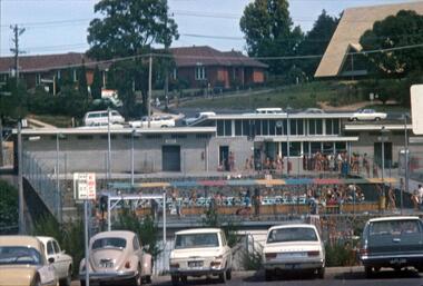
Photograph - Digital Image, R. Max Neumann, Greensborough Main Swimming Pool 1970, 1970_02
Greensborough Swimming Pool, main pool, February 1970.An early photograph of the Pool, now demolished to make way for the Watermarc developmentDigital copy of colour photographgreensborough swimming pool, greensborough pool, watermarc -
![Newspaper Clipping, Horse riding reaches milestone : [Diamond Valley Special Development School DV5161], 02/11/2016](/media/collectors/4f729f5697f83e03086015b8/items/5933c808d0cdd11488ffdf03/item-media/5933c839d0cdd11488fff717/item-fit-380x285.jpg) Greensborough Historical Society
Greensborough Historical SocietyNewspaper Clipping, Horse riding reaches milestone : [Diamond Valley Special Development School DV5161], 02/11/2016
Diamond Valley Special Development School DV5161 celebrated 21 years of horse riding.News clipping, black text and colour image. diamond valley special development school -
 Greensborough Historical Society
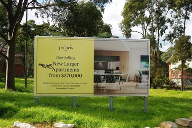
Photograph - Digital Image, Marilyn Smith, Polaris sign at Larundel, 05/09/2017
This photograph shows the Polaris sign at the old Larundel Hospital site. Some buildings on this site are heritage listed on the Victorian Heritage Database. The Polaris development has utilised the open space at Larundel for residential and commercial use.Digital copy of colour photographlarundel hospital, polaris -
 Greensborough Historical Society
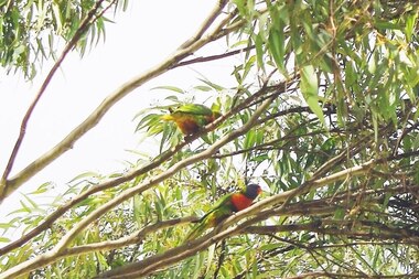
Photograph - Digital Image, Marilyn Smith, Birds at Larundel, 05/09/2017
This photograph shows some wildlife (birds) at the old Larundel Hospital site. Some buildings on this site are heritage listed on the Victorian Heritage Database. The Polaris development has utilised the open space at Larundel for residential and commercial use.Digital copy of colour photographlarundel hospital, polaris, birds -
 Greensborough Historical Society
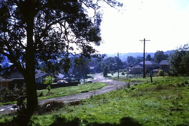
Photograph - Digital Image, Turner Street from Flodden Way, 1966-1969
Looking down Turner Street from 1 Flodden Way. Unmade road and no footpath. Fields in background beyond roof tops. Cars in the driveways. The Noone family lived at 1 Flodden Way from 1966 to 1969. Caption by Julie Noone 2017.Shows the development of the area in the 1960s.Digital copy of colour photograph, taken from photographic slide.flodden way briar hill -
 Greensborough Historical Society
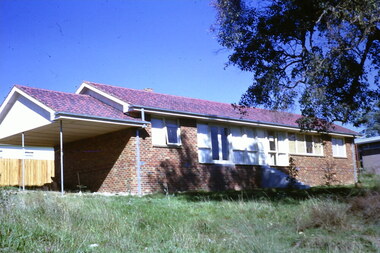
Photograph - Digital Image, No 1 Flodden Way Briar Hill, 1966-1969
Our place, 1 Flodden Way. Clinker brick (It has been extended beyond recognition since then). The Noone family lived at 1 Flodden Way from 1966 to 1969. Caption by Julie Noone 2017.Shows the development of the area in the 1960s.Digital copy of colour photograph, taken from photographic slide.flodden way briar hill -
 Greensborough Historical Society
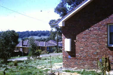
Photograph - Digital Image, View from Flodden Way Briar Hill, 1966-1969
View from Flodden Way, looking across to the next ridge. "I remember a row of houses being burnt beyond that ridge at Diamond Creek and having ash inside our home." The Noone family lived at 1 Flodden Way from 1966 to 1969. Caption by Julie Noone 2017.Shows the development of the area in the 1960s.Digital copy of colour photograph, taken from photographic slide.flodden way briar hill -
 Greensborough Historical Society
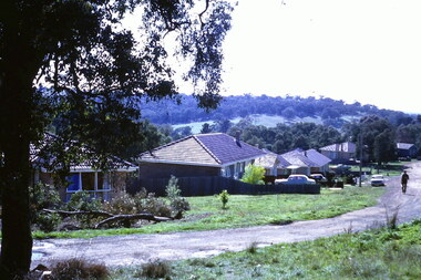
Photograph - Digital Image, Turner Street from Flodden Way Briar Hill, 1966-1969
View from Flodden Way, looking down Turner Street. "The road went round the tree". The Noone family lived at 1 Flodden Way from 1966 to 1969. Caption by Julie Noone 2017.Shows the development of the area in the 1960s.Digital copy of colour photograph, taken from photographic slide.flodden way briar hill -
 Greensborough Historical Society
Photographic Slides, Flodden Way Briar Hill, 1966-1969
Set of photographic slides of Flodden Way and Turner Street Briar Hill, accompanied by letter from donor with captions for each slide.Shows the development of the area in the 1960s.4 photographic slides and typed letter from donor.flodden way briar hill, turner street briar hill -
 Greensborough Historical Society
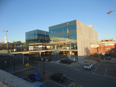
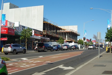
Photograph - Digital image, Marilyn Smith, 78 Main Street Construction - Front View, 18/01/2016
Development on Main Street Greensborough (front), January 2016. Shows the changing streetscape of Main Street.Digital copy of colour photographmain street greensborough -
 Greensborough Historical Society
Photograph - Digital image, Marilyn Smith, 78 Main Street Construction - Rear View, 18/01/2016
Development on Main Street Greensborough (rear view), January 2016. Shows the changing streetscape of Main Street.Digital copy of colour photographmain street greensborough -
 Greensborough Historical Society
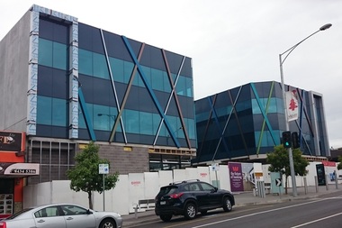
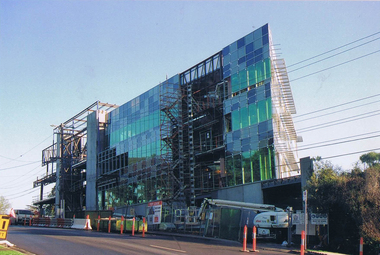
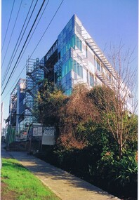
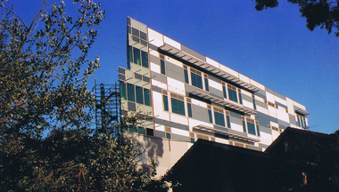
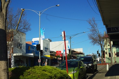
Photograph - Digital image, Marilyn Smith, Crane at Watermarc, 11/08/2016
Cranes on the skyline at Watermarc development 2016. New Banyule Council offices are being built at 1 Flintoff Street, over the Watermarc building.Digital copy of colour photograph.watermarc, one flintoff, banyule council -
 Greensborough Historical Society
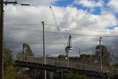
Photograph - Digital image, Marilyn Smith, Crane at Watermarc, 19/07/2016
Cranes on the skyline at Watermarc development 2016, taken from Main Street. New Banyule Council offices are being built at 1 Flintoff Street, over the Watermarc building.Digital copy of colour photograph.watermarc, one flintoff, banyule council, main street greensborough -
 Greensborough Historical Society
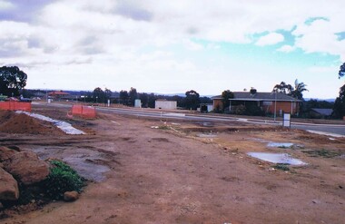
Photograph - Digital image, Marilyn Smith, Tree, Poulter Avenue and Main Street, 20/10/2016
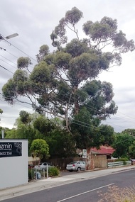
This established tree in Poulter Avenue Greensborough is at risk from development of the surrounding properties.Established trees such as this have been removed as the area is developed.Digital copy of 3 colour photographspoulter avenue greensborough -
 Greensborough Historical Society
Photograph - Digital image, Frank Solomon, Grimshaw Street development 1, 04/06/2010
View of development on Grimshaw Street Greensborough. This building houses the Centrelink office.Digital copy of colour photographcentrelink greensborough, grimshaw street greensborough -
 Greensborough Historical Society
Photograph - Digital image, Frank Solomon, Grimshaw Street development 2, 04/06/2010
View of development on Grimshaw Street Greensborough. This building house the Centrelink office.Digital copy of colour photographgrimshaw street greensborough, centrelink greensborough -
 Greensborough Historical Society
Photograph - Digital image, Frank Solomon, Grimshaw Street development 3, 04/06/2010
Property development in Grimshaw Street Greensborough. This building houses the Centrelink office.Digital copy of colour photographgrimshaw street greensborough, centrelink greensborough -
 Greensborough Historical Society
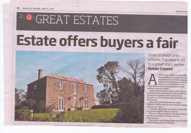
Newspaper Clipping, Herald Sun, Estate offers buyers a fair deal, 24/04/2010
This article advertises a new residential development "Fairview" in Bridge Inn Road Mernda.News clipping, text and colour image.mernda, bridge inn road mernda -
 Greensborough Historical Society
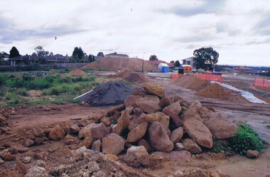
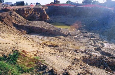
Photograph - Digital image, Frank Solomon, Development of pig farm to residential blocks, 1, 02/08/2009
A view of the redevelopment of the pig farm in Weidlich Road Greensborough, owned by Werner Hanusch. The land was used as a pig farm and quarry from 1954 and this photo shows early stages of the land being subdivided into the Evelyn Way estate. This project of fifty, one double storey, dwellings was commenced on 2/8/2009 and completed on 6/2/2011.An example of the changing land use in Greensborough, from farming to residential.Digital copy of colour photographwerner otto fritz hanusch, pig farm st helena, weidlich road greensborough, one evelyn way greensborough -
 Greensborough Historical Society
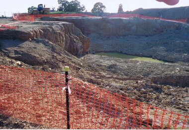
Photograph - Digital image, Frank Solomon, Development of pig farm to residential blocks, 2, 02/08/2009
A view of the redevelopment of the pig farm in Weidlich Road Greensborough, owned by Werner Hanusch. The land was used as a pig farm and quarry from 1954 and this photo shows early stages of the land being subdivided into the Evelyn Way estate. This project of fifty, one double storey, dwellings was commenced on 2/8/2009 and completed on 6/2/2011.An example of the changing land use in Greensborough, from farming to residential.Digital copy of colour photographwerner otto fritz hanusch, pig farm st helena, weidlich road greensborough, one evelyn way greensborough -
 Greensborough Historical Society
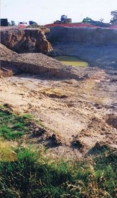
Photograph - Digital image, Frank Solomon, Development of pig farm to residential blocks, 3, 02/08/2009
A view of the redevelopment of the pig farm in Weidlich Road Greensborough, owned by Werner Hanusch. The land was used as a pig farm and quarry from 1954 and this photo shows early stages of the land being subdivided into the Evelyn Way estate. This project of fifty, one double storey, dwellings was commenced on 2/8/2009 and completed on 6/2/2011.An example of the changing land use in Greensborough, from farming to residential.Digital copy of colour photographwerner otto fritz hanusch, pig farm st helena, weidlich road greensborough, one evelyn way greensborough -
 Greensborough Historical Society
Photograph - Digital image, Frank Solomon, Development of pig farm to residential blocks, 4, 02/08/2009
A view of the redevelopment of the pig farm in Weidlich Road Greensborough, owned by Werner Hanusch. The land was used as a pig farm and quarry from 1954 and this photo shows early stages of the land being subdivided into the Evelyn Way estate. This project of fifty, one double storey, dwellings was commenced on 2/8/2009 and completed on 6/2/2011.An example of the changing land use in Greensborough, from farming to residential.Digital copy of colour photographwerner otto fritz hanusch, pig farm st helena, weidlich road greensborough, one evelyn way greensborough -
 Greensborough Historical Society
Photograph - Digital image, Frank Solomon, Development of pig farm to residential blocks, 5, 02/08/2009
A view of the redevelopment of the pig farm in Weidlich Road Greensborough, owned by Werner Hanusch. The land was used as a pig farm and quarry from 1954 and this photo shows early stages of the land being subdivided into the Evelyn Way estate. This project of fifty, one double storey, dwellings was commenced on 2/8/2009 and completed on 6/2/2011.An example of the changing land use in Greensborough, from farming to residential.Digital copy of colour photographwerner otto fritz hanusch, pig farm st helena, weidlich road greensborough, one evelyn way greensborough -
 Greensborough Historical Society
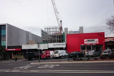
Photograph - Digital image, Marilyn Smith, New construction, Main Street Greensborough, 19/08/2015
New development centred on 78 Main Street Greensborough.Digital copy of colour photographmain street greensborough -
 Greensborough Historical Society
Photograph - Digital image, Marilyn Smith, New construction, Main Street Greensborough, 19/08/2015
New development at 78 Main Street Greensborough. Photo centres on the Amcal Chemist at 100 Main Street.Digital copy of colour photographmain street greensborough -
 Glenelg Shire Council Cultural Collection
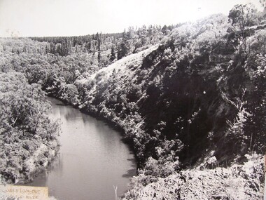
Photograph - Photograph - Jones' Lookout, n.d
Glenelg Shire Council records Portland Development Committee.Photograph of Jones Lookout, Glenelg River.Front: Sticker bottom left. 'Jones' Lookout Glenelg River' - penjones lookout, portland, scenery -
 Glenelg Shire Council Cultural Collection
Photograph - Photograph - Pivot, Portland, n.d
Photograph of Pivot beach and area Portland.Back: Blue stamp - Portland Development Committee. 'The Phosphate Co-operative Co. Ltd. - manufacturers of superphosphate fertilizer' - grey lead.pivot, industry, harbour, fertiliser -
 Glenelg Shire Council Cultural Collection
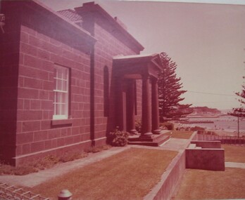
Photograph - Photograph - Portland Court House, n.d
Glenelg Shire Council Records. Portland Development Committee.Photograph of Portland Court HouseBack: Blue stamp - Portland Development Committeeportland court house, municipal, law, legal, civic buildings -
 Glenelg Shire Council Cultural Collection
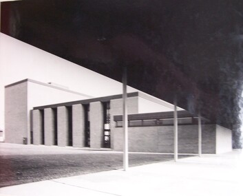
Photograph - Photograph - Civic Hall, Portland, n.d
Glenelg Shire Council records.Black and white photograph of side of Civic Hall, Portland, taken from front left.Back: Portland Development Committee (centre, blue stamp)portland civic hall