Showing 10610 items
matching sites
-
 Whitehorse Historical Society Inc.
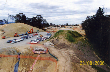
Photograph, Eastlink
Five coloured photos of the Eastlink Project at the Deep Creek Road site, Mitcham on 23 August 2006eastlink, thiess-john holland, deep creek road mitcham -
 Whitehorse Historical Society Inc.
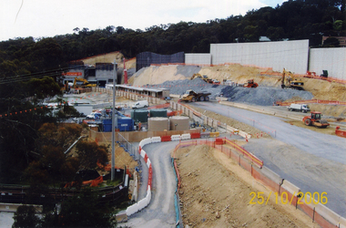
Photograph, Eastlink
Three Coloured photos of the Eastlink project at the Deep Creek Road site, Mitcham -25th October 2006eastlink, thiess - john holland, deep creek road mitcham -
 Whitehorse Historical Society Inc.
Photograph, Eastlink
Two coloured Photos of the Eastlink Project at the Deep Creek Road site, Mitcham on 6th December 2006eastlink, thiess-john holland, deep creek road mitcham -
 Whitehorse Historical Society Inc.
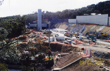
Photograph, Eastlink
Four coloured photos of the Eastlink project at Deep Creek Road site, Mitcham on 8th Jan 2007eastlink, thiess john holland, deep creek road, mitcham -
 Lakes Entrance Regional Historical Society (operating as Lakes Entrance History Centre & Museum)
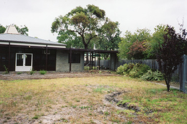
Photograph, 2003
Colour photograph of site works at the previous Heatherlea Grove Kindergarten before it was demolished, Lakes Entrance Victoriaeducation -
 Robin Boyd Foundation
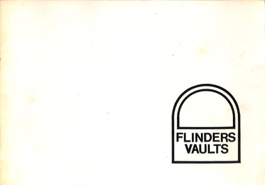
Booklet - Proposal, Robin Boyd, Flinders Vaults, Jan-72
Project: Flinders Vaults drawn by Robin Boyd of Romberg and Boyd.Booklet, 8 pages, with text and drawings (site plan. plan elevations, interior perspectives, external perspective). -
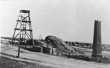 Stawell Historical Society Inc
Photograph, Sloane's & Scotchman United Quartz Mining Company remains of Poppet Head, Chimney & Engine Mounts
Sloane's & Scotchman Mining Co remains Poppet Head Chimney and Engine Mounts.Derelict mine site at upper main street. Engine housing brickwork and Chimney at right partly demolished.stawell mining -
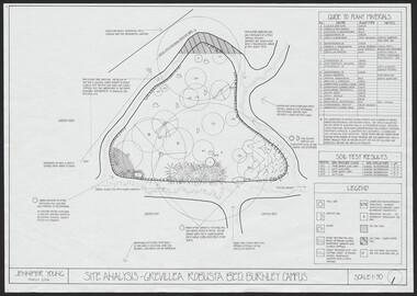 University of Melbourne, Burnley Campus Archives
Plan, Jennifer Young, Grevillea Robusta Bed, 2006
(1) Site Analyis. (2) Plant Survey by Jennifer Young, March 2006. (3) Plant Plan.jennifer young, grevillea -
 University of Melbourne, Burnley Campus Archives
Work on paper (item) - Student Work, Hawthorn Site Analysis
Likely created as an assignment for HORT90035, 'Landscape Construction and Graphics,' a subject at Burnley Horticultural College coordinated by Andrew Laidlaw. This is due to the fact that it was found amongst other work submitted for this subject. This would mean that some other papers are missing. assignment, burnley -
University of Melbourne, Burnley Campus Archives
Work on paper (item) - Survey Plan, Thomas and George Licensed Surveyors, Partial Feature Survey Plan 125 Dee Road Millgrove 3799, 25th February, 2014
Prepared for building and landscape design purposes. It was created by a company called 'Thomas and George Licensed Surveyors' and the survey was conducted on the 24th February 2014. 125 dee road, millgrove, survey plan -
 Bendigo Historical Society Inc.
Slide - BENDIGO & EASTER FAIR, 1983
Wooden cottage, single front door, two windows. Used in Eureka Stockade TV production site.slide, bendigo, eureka stockade, tv production site, eureka stockade tv priduction site -
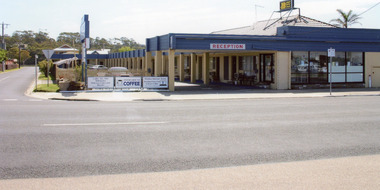 Lakes Entrance Regional Historical Society (operating as Lakes Entrance History Centre & Museum)
Photograph - Vizes Cafe. Bamboo Motel, 2008
Date made August 2008Colour photograph of the Bamboo Motel which is situated on the site of Vizes Cafe on Esplanade, Lakes Entrance, Victoria.motels, tourism, restaurant, room display -
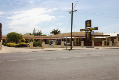 Lakes Entrance Regional Historical Society (operating as Lakes Entrance History Centre & Museum)
Photograph, 2008
Date made August 2008Colour photograph of Esplanade Motel which is situated on the site of Victoria House, on Esplanade at Lakes Entrance, Victoria.guesthouses, motels, room display -
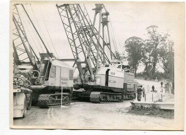 Orbost & District Historical Society
black and white photographs, 1974 - 1976
Construction of the roadway embankment between the bridges across the Snowy River flood plains at Orbost commenced in January 1974 and was completed in November 1976. Pearsons were the bridge contractors for the construction of the Princes Freeway and bridges across the river flood plains at Orbost. Heavy rains and floods held up progress.These photographs are of the construction of a major structure in Orbost. The opening of this Snowy River Bridge was an important development in the accessibility to the township of Orbost.Four black / white photographs of construction sites. 3241.1 is of three cranes and other machinery with six persons. 3241.2 is of workmen working on flooded site. 3241.3 is a photograph of the early stages of construction of a bridge looking towards the township. 3241.4 shows the construction of a roadway between the bridges.construction-snowy-river-bridge bridge-orbost -
University of Melbourne, Burnley Campus Archives
Administrative record - Garden Management and Maintenance, Victorian College of Agriculture and Horticulture, Miscellaneous Planning Documents, C.1997
master plan, burnley gardens, garden maintenance, garden management, vcah, herb garden -
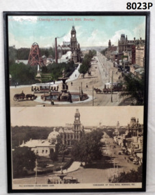 Bendigo Military Museum
Photograph - PHOTOGRAPHS, MOUNTED, Charing Cross/Pall Mall, C.2000
The mine was the “Hustlers Royal Reserve Mine No 2” and was closed in 1912. The Soldiers Memorial Institute was erected on the mine site and opened on 15.11.1921 and occupied by the Bendigo RSL Sub Branch/Bendigo District RSL Sub Branch Inc since then. The mine shaft capped sits about centre of the building.Two gloss coloured prints on fibre board backing. Top photo tinted of Alexander Fountain, Charing Cross and Pall Mall Bendigo. Gold mine poppet head and buildings on left hand side. 53464 VJ printed on R.H.S. bottom. Bottom photo black and white of Panorama of Pall Mall., Bendigo, Vic. Soldiers Memorial on left hand side occupying old gold mine site.“The Southern Cross Series 10399. Copyright on bottom L.H.S. Panorama of Pall Mall, Bendigo on R.H.S. bottom”brsl, smirsl, hustlers -
 Tarnagulla History Archive
Photograph of stables behind bank building, Tarnagulla, Stables behind bank building, Tarnagulla, circa 1970s
Murray Comrie Collection. This image depicts the stables at rear of a two-storey bank building in Tarnagulla. The bank building was used first by the Colonial Bank of Australasia (from 1866 to 1888) and then by the Union Bank (from 1888 to 1942). The two-storey bank building was built in 1866 by the Colonial Bank of Australasia. Before this, the site had been occupied by Foo's shop. Whilst it was being built, the Colonial Bank operated from Company's Hotel (later known as Burstall Hall and the Council Chambers). The new double-storey building was used by the Colonial Bank from 1866 until 21st February, 1888. The premises were sold to the Union Bank for £2500. The Union Bank moved in and commenced operations on 6th June 1888, continuing until 1942. The building was later used as a general store until the 1990s. It is now a private residence. This is a reasonable copy of an older original. Copy probably made by Murray Comrie in the 1970s. Monochrome photograph depicting stables at rear of the double-storey bank building in Tarnagulla. Image depicts a brick building with white timber doors and corrugated metal roof. The site was originally built by and for the Colonial Bank and later used by the Union Bank. tarnagulla, banks, banking, commerce, buildings, commercial road, horses, stables -
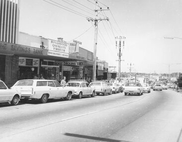
 Ringwood and District Historical Society
Photograph, Maroondah Highway East, Ringwood- 1969. Looking west towards Ringwood from Everard Road
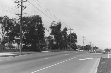
Black and white photographWritten on back of photograph: "Site of Cass's school, 1874. (1 acre left out of 5 acres). -
 Ringwood and District Historical Society
Photograph, Ringwood Clocktower - circa 1960's
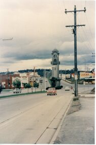
Postcard size colour photograph'Written on back of photograph" Clock Tower - original site, middle of Maroondah Highway and Warrandyte Road intersection. -
Glenelg Shire Council Cultural Collection
Photograph - Photograph - Henderson & Cross Wheelwrights, Portland, n.d
Black and white photo attached to beige cardboard mount. Workshop of Henderson & Cross, Wheelwrights and Horseshoers, in Percy St. Portland. Corrugated iron building large open wooden doors, several men standing outside, numerous spoked wheels, 3 horses on right.Back: 'VIVIAN' 'Portland On site of Mrs. A. Naismiths' home Percy St.' - hand printed in blue birotrade, industry, travel, wheelwright, horseshoer, portland, percy street -
 Ringwood and District Historical Society
Photograph, Ringwood black and white photographs
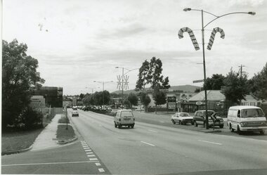
Black and white photographMaroondah Hwy. view East from bonview Ave near proposed site of Eastern Ring Road -
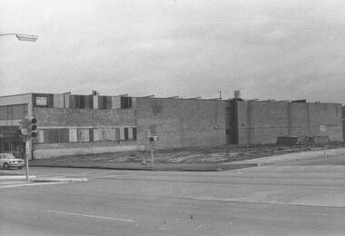
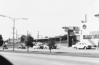
 Ringwood and District Historical Society
Photograph, Maroondah Highway Central, Ringwood. Site of old Town Hall, cnr. Maroondah Highway and Melbourne St, Ringwood - 1971
Black and white photograph (2 copies- 1 large, 1 small)Written on rear backing sheet: "Site of old town hall. Cnr. Maroondah Highway and Melbourne St." -
 Ringwood and District Historical Society
Photograph, Maroondah Highway Central, Ringwood. Site of old Town Hall cnr. Maroondah Hwy and Melbourne St., Ringwood - 1971
Black and white photograph (2 copies- 1 large, 1 small)Written on rear of backing sheet: "Site of old Town Hall cnr. Maroondah Hwy and Melbourne St." -
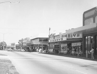 Ringwood and District Historical Society
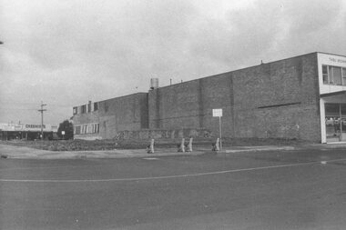
Photograph, Maroondah Highway Central, Ringwood. Shops on site of old Town Hall, corner of Melbourne Street, 1972
Black and white photograph (2 copies) Written on rear of backing sheet: "Shops on site of old Town Hall. Cnr. Melbourne St. 1972" -
 Glenelg Shire Council Cultural Collection
Photograph - Photograph - wheat storage construction, Portland, c. 1970
Port of Portland Authority archivesFront: (no inscriptions) Back: Northern Trench, Wheat Storage Site, June 11th (pencil, upper left)port of portland archives, wheat storage, construction -
Glenelg Shire Council Cultural Collection
Photograph - Photograph - wheat storage construction, Portland, c. 1970
Port of Portland Authority archivesFront: (no inscriptions) Back: Southern Trench, wheat storage site, June 11th (pencil, upper left)port of portland archives -
 Kew Historical Society Inc
Photograph - Burgess House, Victoria Street (Abbotsford), 1880-1900
Major floods recurred of the Yarra River on a regular basis. A flood in 1901 destroyed this house in Victoria Street, Abbotsford. Later print copy of an original photograph. Home of C/N Burgess on the south side of Yarra River. The buildings were washed away in a flood in 1901 The house was in the same location as that on which Handley & Tilly was later built. This would locate it on the north side of Victoria Street, Abbotsford between Burnley Street and the Victoria Street Bridge. Photo shows three men and one woman working in an established garden in front of a weatherboard cottage."Home of C/N Burgess on south side of river; washed away in 1901; Handley & Tilly on site"yarra river -- floods, yarra river flood -- 1901, burgess family -- victoria street -- abbotsford (vic.) -
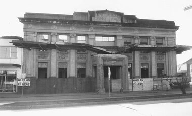 Ringwood and District Historical Society
Photograph, Maroondah Highway Central, Ringwood. Demolition of Ringwood Town Hall - 1971
Black and white photograph (2 copies- 1 large, 1 small)Whelan the Wrecker is here, midway Alexander Clothing to leftWritten on backing sheet, "Town Hall demolition". Sign at front of site reads- 'Whelan the wrecker is here'. -
 Ringwood and District Historical Society
Photograph, Maroondah Highway Central, Ringwood. Main St. shops opp. old Ringwood Town Hall site, 1974
Black and white photograph.Written on rear of backing sheet: "Main St. shops opp. old Town Hall site, 1974". -
 Ringwood and District Historical Society
Photograph, Maroondah Highway Central, Ringwood. Bus terminus at Railway Station, 1969
Black and white photographWrittren on back of photograph: "May 1969, bus terminus at Railway Station. Site of Station Masters house.