Showing 1293 items
matching 1857
-
 Eltham District Historical Society Inc
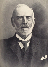
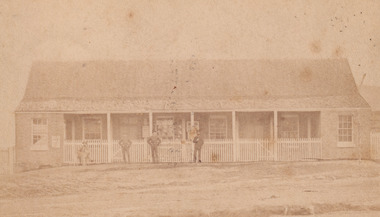
Photograph, C.S. Wingrove, Secretary, Eltham District Road Board 1858-1871; Shire Secretary, Shire of Eltham 1871-1904, 1858-1871
Charles Symons Wingrove, J.P. (1829-1905) arrived in Victorian in 1851. He had trained as an engineer, but tried his luck on the goldfields. In 1857 he was appointed as Secretary to the Eltham District Roads Board only one year after its foundation. He was to hold the position with the Board and later the Eltham Shire Council for total of 47 years. He also held the position of engineer for a large part of this period. During part of this time he was also secretary to the Heidelberg Shire Council. Over this period he was responsibly for an area stretching from Clifton Hill to Healesville, along the northern bank of the Yarra River. Other positions included Secretary to the Victorian Agricultural Society over along period.Wingrove was a main figure in the Municipal Association of Victoria. By the time he retired he was recognized as the “Grand Old Man” of Victorian local government. In 1858 Wingrove had a brick cottage built in Main Road near the State School and he lived here until his death. One room was uded as the Board and Council office. His descendants owned the house until 1974. It was later used as a psychiatric clinic. The park opposite the cottage has been named Wingrove Park in his honour. He is buried at St Helena with other members of his family. Age (Melbourne, Vic. : 1854 - 1954), Tuesday 18 July 1905, page 5 ABOUT PEOPLE. A conspicuous figure in northern municpal history, Mr. Charles Symons Wingrove, has passed away. He was for many years secretary and engineer for the shire of Eltham, and prior to the formation of the shire held the position under the old road board, his official connection with the district dating from beyond 1857. For about twelve years he also filled the position of shire engineer for Heidelberg council while retaining his other post, and the immense territory under his professional control, reaching from the boundary of Collingwood up to Healesville, was a matter of fatherly pride and interest to him. He arrived in Victoria in 1851, and was 76 years of age at his death. Mr. Wingrove retired from the position in the Eltham council only about a year ago. The interment will take place in St. Helena Cemetery, near Eltham township, today. Secretary, Eltham District Road Board 1858-1871 Secretary for the Shire of Eltham 1871-1904. Nearly 50 years service to the local community. For about twelve years he also filled the position of shire engineer for Heidelberg council. Reproduced Page 137 "Pioneers & Painters" This photo forms part of a collection of photographs gathered by the Shire of Eltham for their centenary project book,"Pioneers and Painters: 100 years of the Shire of Eltham" by Alan Marshall (1971). The collection of over 500 images is held in partnership between Eltham District Historical Society and Yarra Plenty Regional Library (Eltham Library) and is now formally known as the 'The Shire of Eltham Pioneers Photograph Collection.' It is significant in being the first community sourced collection representing the places and people of the Shire's first one hundred years.Digital image Print 25 x 20 cmc.s.wingrove, charles symons wingrove, eltham district road board, sepp, shire of eltham pioneers photograph collection, shire secretary, wingrove cottage, pioneers and painters, shire of eltham, councilor, municipal officer -
 Eltham District Historical Society Inc
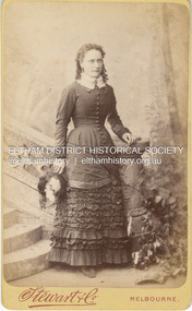
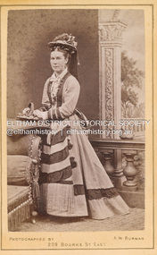
Photograph, Stewart & Co, Possibly Margaret Shillinglaw, c.1882
Margaret Shillinglaw was William and Jean Shillinglaw's ninth child. She was born at Northcote March 3, 1856 and died at North Fitzroy September 7, 1933. She never married. Stewart & Co operated from 217 Bourke St., East from 1871 to 1876 and from 217-219 from 1877 to 1889. Other locations included 42, 284 and 286. Overall, they operated in Melbourne from 1871 through at least 1910 though Carte-de-Visite photos were superseded by 1890. According to Lenore Frost's book, Dating Family Photos 1850-1920, the swathes of contrasting fabric across her abdomen is a peculiarity of 1882. CARTE-DE-VISITE (cdv) 1857-1890 Cartes-de-visite (cdv's) are the most common form of photograph from the nineteenth century, generally measuring two and a half inches by four and an eighth inches (6.3 x 10.5 cm) when mounted, sepia toned, mounted on a card which was generally printed with the photographer's name and address on the back or beneath the portrait. - Frost, Lenore; Dating Family Photos 1850-1920; Valiant Press Pty. Ltd., Berwick, Victoria 1991marg ball collection, shillinglaw family photo album 1, 1871-1890, 1882, margaret shillinglaw (1856-1933), stewart & co photographers melbourne, unknown -
 Eltham District Historical Society Inc
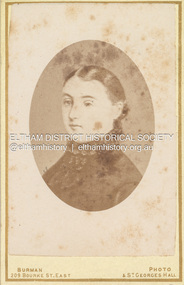
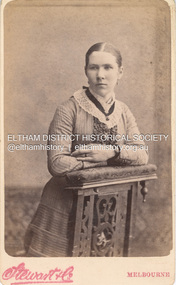
Photograph, W.J. Burman, Eva Carmichael, sole surviving passenger of the wreck of the Loch Ard, 1878
Special Carte-de-Visite produced by W. Burman, July 3,1878 featuring the sole surviving passenger of the wreck of the ship, Loch Ard near Mutton Bird Island on the Shipwreck Coast of Victoria on June 1st, 1878. THE PHOTOGRAPHIC SOCIETY. (1878, October 12). The Age (Melbourne, Vic. : 1854 - 1954), p. 7. Retrieved December 4, 2022, from http://nla.gov.au/nla.news-article199353573 According to Sands & McDougall Melbourne Directory, Burman's were operating from 209 Bourke St. East and St George's Hall (73 Bourke St. East) from 1879-1885 Back of photo is overtsamped "Registered Copyright by W. Burman, July 3rd 1878" CARTE-DE-VISITE (cdv) 1857-1890 Cartes-de-visite (cdv's) are the most common form of photograph from the nineteenth century, generally measuring two and a half inches by four and an eighth inches (6.3 x 10.5 cm) when mounted, sepia toned, mounted on a card which was generally printed with the photographer's name and address on the back or beneath the portrait. - Frost, Lenore; Dating Family Photos 1850-1920; Valiant Press Pty. Ltd., Berwick, Victoria 1991marg ball collection, 1878, 1878-1885, burman's photographer 209 bourke st east and st georges hall melbourne, shillinglaw family photo album 2, eva carmichael, loch ard (ship) -
 Federation University Historical Collection
Book, Birds of Australia, early 1890s
Not Gould although on spine. Minutes of the SMB council 14 April 1891 "6, A requisition from Professor Krause for a new work on the birds of Australia was referred to the Education committee. Broinowski was commisioned by the Department of Public Instruction in New South Wales to supply them with pictures of Australian birds which he published in 6 volumes from 1887 - 1891. Gracius Broinowski was born in Poland in 1837. To avoid conscription with the Russian army he roamed Europe in poverty,his possessions having been stolen earlier in Germany. Hearing tales of the Australian gold fields, he borderd the 'Windjammer' bound for Victoria as a deckhand. Broinowski swam ashore at Portland, Victoria in 1857 age twenty. For seven years he walked from one rural settlement to another working as a shepherd, stockman and independent farmer. In 1864 Bronoiwski married in Melbourne and found work with Hamel & Ferguson (print sellers and publishers). 'The Birds of Australia' was finalised in 1891 with 303 full page illustrations lithographed in colour with notes on over 700 species. Limited to 1000 copies the edition sold out quickly. Bronowski died in 1913 at Mosmon NSW, aged 76. He was survived by his wife, a daughter and 6 sons.Green hard cover book, black leather spine and corners. Title on spine written in gold letters, gold decorations on spine. Pages not numbered. Coloured plates (lithographs). Vol. 1 - 6. Printed and bound.Stamped throughout the book "School of Mines Ballarat Library".birds, gracius j. broinowski, fauna, ballarat technical art school library -
 Bendigo Historical Society Inc.
Photograph - Norman Penrose collection: Views of Bendigo No.31
The initial partnership in a quartz crushing plant between Henry Koch, Simon Albert and Charles Wallin was dissolved in 1860 with Koch becoming the sole owner. In 1866 the crushing plant consisted of a 50 hp engine and 48 stamping heads capable of crushing 600 tons of quartz per week. By 1902 there were 72 stamps and this was by far the largest crushing plant in the area, serving many quartz mines. Henry Koch (1800-1889) was a German sailor who signed off when his ship reached Melbourne in 1851. Having heard of the gold discovery he proceeded to Bendigo where he was initially employed in puddling in the Myers Flat area. He was soon employed and then made partner in a quartz crushing plant that he became sole owner of in 1860. He was also landlord at the British and American Hotel and the Silver Mines Hotel. HE also started the Perseverance United gold claim. He married Anna Maria Theresia Heinz in 1857. In 1872 he sold the crushing plant for 75,000 pounds and took his family back to Germany. He resumed his trade as a ship builder although he maintained many Bendigo mining interests.Sepia coloured photograph of Koch's Pioneer quartz crushing plant, Long Gully. The phot shows Perseverance United claim, Wind-mill and hill in the distance. N.J. Caire phot Sandhurst.Casey & Wenborn's print. Forbes & Holmes agentsviews of bendigo, n.j. caire, sandhurstr, quartz crushing plant, kock -
 Ballarat Heritage Services
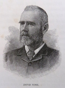
Photograph - Image, David Syme
David Syme (1827-1908) was a newspaper proprietor who was born on 2 October 1827 at North Berwick, Scotland. Early in 1851, he went via Cape Horn to California seeking gold. By mid-1852 he was in Melbourne, and in the next three years prospected with some success on Ballarat, Bendigo, Castlemaine and Beechworth diggings. In 1855 he lost a possible fortune at Egerton near Ballarat when a promising claim was jumped. Ebenezer Syme bought the insolvent Melbourne Age for £2000, and invited David Syme to take up a share. In September 1856 Syme put up some cash and his contracting business to obtain a half-share. He helped to manage the paper but returned to contracting late in 1857. When Ebenezer retired in 1859 Syme reluctantly returned to the business, and on Ebenezer's death next year he began his fifty-year career as publisher and editor of the Age. (C. E. Sayers, 'Syme, David (1827–1908)', Australian Dictionary of Biography, National Centre of Biography, Australian National University, http://adb.anu.edu.au/biography/syme-david-4679/text7741, published first in hardcopy 1976, accessed online 25 August 2019._Reproducation of a image of David Syme.david syme, portrait, the age, journalist -
 Ballarat Heritage Services
Photograph - Image, David Syme, 1934
David Syme (1827-1908) was a newspaper proprietor who was born on 2 October 1827 at North Berwick, Scotland. Early in 1851, he went via Cape Horn to California seeking gold. By mid-1852 he was in Melbourne, and in the next three years prospected with some success on Ballarat, Bendigo, Castlemaine and Beechworth diggings. In 1855 he lost a possible fortune at Egerton near Ballarat when a promising claim was jumped. Ebenezer Syme bought the insolvent Melbourne Age for £2000, and invited David Syme to take up a share. In September 1856 Syme put up some cash and his contracting business to obtain a half-share. He helped to manage the paper but returned to contracting late in 1857. When Ebenezer retired in 1859 Syme reluctantly returned to the business, and on Ebenezer's death next year he began his fifty-year career as publisher and editor of the Age. (C. E. Sayers, 'Syme, David (1827–1908)', Australian Dictionary of Biography, National Centre of Biography, Australian National University, http://adb.anu.edu.au/biography/syme-david-4679/text7741, published first in hardcopy 1976, accessed online 25 August 2019._Reproducation of a image of David Syme.david syme, portrait, the age, journalist -
 Mt Dandenong & District Historical Society Inc.
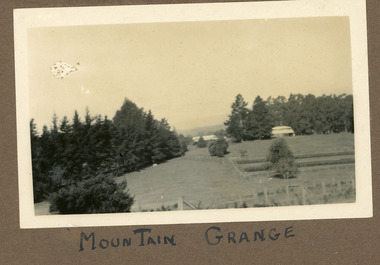
Photograph
The photograph is from the album of Ivy Child. It shows a rare scene of the Mountain Grange Homestead. Mountain Grange was built by Thomas Hand on his 306 acres. By 1881 he had completed the homestead and a large barn. Thomas Hand died suddenly in 1888 and his family took over the property. His son William Hand lived in the homestead until 1931 until it was demolished due to white ants. The great barn was demolished in 1930. A new home was built and Will stayed until 1939 when the property was sold to the Shire of Lillydale. It is now the site of the Kalorama Oval. This photograph is c1927 Ivy May Child (1910 – 1989) was the daughter of Arthur Edward (Ted) Child (1878 – 1964) and Ethel May Madden (1888 – 1970). Ted Child was the son of Matthew Francis Child (1839 – 1933) and Martha Jeeves (1857 – 1926). He was the grandson of one of the early pioneers Francis Child. Ivy grew up on the family property on Childs Road and took many photographs. Most of these are glued into her photo album. The album covered the years from c1927 – 1932. Ivy married Henry William Burgess (1906 – 1968) in 1944. The photographs remain in their original state in the album with individual copies made. Black and white photograph showing a cleared area. There is a wire and posr fence in the foreground, a tall row of pine trees across the centre with two buildings visible. One in front of the trees RHS and he other in a gap in the centre. A crop has been planted in two long rows centre right of the photograph.Handwritten below the photograph in the album: MOUNTAIN GRANGEivy child, mountain grange, thomas hand, william hand, will hand, barn, great barn, homestead, shire of lillydale, kalorama oval -
 Bendigo Historical Society Inc.
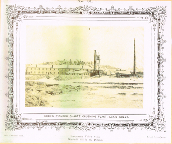
Photograph - LONG GULLY HISTORY GROUP COLLECTION: KOCK'S PIONEER QUARTZ CRUSHING PLANT LONG GULLY
The initial partnership in a quartz crushing plant between Henry Koch, Simon Albert and Charles Wallin was dissolved in 1860 with Koch becoming the sole owner. In 1866 the crushing plant consisted of a 50 hp engine and 48 stamping heads capable of crushing 600 tons of quartz per week. By 1902 there were 72 stamps and this was by far the largest crushing plant in the area, serving many quartz mines. Henry Koch (1800-1889) was a German sailor who signed off when his ship reached Melbourne in 1851. Having heard of the gold discovery he proceeded to Bendigo where he was initially employed in puddling in the Myers Flat area. He was soon employed and then made partner in a quartz crushing plant that he became sole owner of in 1860. He was also landlord at the British and American Hotel and the Silver Mines Hotel. HE also started the Perseverance United gold claim. He married Anna Maria Theresia Heinz in 1857. In 1872 he sold the crushing plant for 75,000 pounds and took his family back to Germany. He resumed his trade as a ship builder although he maintained many Bendigo mining interests.Yellow tone photo which has some green through it photo of Kock's Pioneer Quartz Crushing Plant, Long Gully. No 31 printed at the top. The photo has a decorative frame around it. It is a N. J. Caire Photo, Sandhurst and a Casey & Wenborn's Print. Forbes & Holmes, Agents. The photo has a long two storey building with chimneys and some smaller buildings and tall mine chimneys. Printed below is Perseverance United Claim and Windmill Hill in the distance. Paper is mounted on yellow card which is mounted on dark tan card and laminated.bendigo, history, long gully history group, the long gully history group - koch's pioneer quartz crushing plant - long gully, n j caire, casey & wenburn, forbes & holmes, perseverence united claim, windmill hill -
 Bendigo Historical Society Inc.
Negative - ALBERT RICHARDSON COLLECTION: KOCH'S PIONEER CRUSHING BATTERY (EARLY PERIOD)
The initial partnership in a quartz crushing plant between Henry Koch, Simon Albert and Charles Wallin was dissolved in 1860 with Koch becoming the sole owner. In 1866 the crushing plant consisted of a 50 hp engine and 48 stamping heads capable of crushing 600 tons of quartz per week. By 1902 there were 72 stamps and this was by far the largest crushing plant in the area, serving many quartz mines. Henry Koch (1800-1889) was a German sailor who signed off when his ship reached Melbourne in 1851. Having heard of the gold discovery he proceeded to Bendigo where he was initially employed in puddling in the Myers Flat area. He was soon employed and then made partner in a quartz crushing plant that he became sole owner of in 1860. He was also landlord at the British and American Hotel and the Silver Mines Hotel. HE also started the Perseverance United gold claim. He married Anna Maria Theresia Heinz in 1857. In 1872 he sold the crushing plant for 75,000 pounds and took his family back to Germany. He resumed his trade as a ship builder although he maintained many Bendigo mining interests.Envelope containing a negative of Koch's Pioneer Crushing Battery. Image shows large building, chimney on left. Negative not scanned.bendigo, mining, koch's pioneer crushing battery -
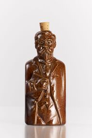 City of Greater Bendigo - Civic Collection
Ceramic - Bendigo Pottery :: Australian Prime Minister Flask, Bendigo Pottery, Alfred Deakin, c 1975
Established by George Guthrie in 1857 (about 5km north of its current site) and then again seven years later in 1864 after it initially closed, Bendigo Pottery remains one of the most influential and longest running Pottery’s in Australia. Over the years the Pottery has contributed to the growth and development of the district through both its products including building products, table ware and decorative and commemorative war as well as artistically, being responsible for training and supporting many potters locally. The City of Greater Bendigo has had a long history of partnering with Bendigo Pottery and the Civic Collection holds a number of important items within its collection. This Alfred Deakin 'reform' flask was one of a limited edition character bottles produced by the Pottery to commemorate important figures in Australian politics. The original reform flasks were English salt-glazed stoneware flasks produced in the early 19th century shaped into the form of figures connected with the Reform Bill of 1832. Much was made of puns like ‘the spirit of reform’ at the time. Artist John Frith has taken the reform flask form as inspiration for a series of political ceramics of some Australian Prime Ministers. The series includes Edmund Barton, Alfred Deakin and Chris Watson.Glazed ceramic flask in the shape Alfred Deakin. Square shaped with most of the detail on the front facing side other than head which is more detailed. Cork still in place in top of head.On reverse of flask; Alfred Deakin / Prime Minister / of Australia / 1903 - 1904 / 1905 - 1908 / 1909 - 1910 Bendigo Pottery / LMTED / Edition Series / 101/200 /Australia Signed lower left; 'Frith'australian politics, bendigo pottery -
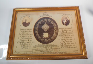 Bendigo Historical Society Inc.
Memorabilia - FRAMED IMAGE OF BENDIGO MAYORAL CHAIN
Large framed item. At the centre a photograph of the Bendigo Mayoral Chain designed and manufactured by F. Prescott, jeweller, Bendigo At the right a photo of George Lansell esq. and on the left a photo of J.H. Abbott esq. A list of Mayor is underneath the two photos, starting from the left J.F. Sullivan 1857, J.H. Abbott 1860, J.J. Casey 1861, R. Burrows 1862, G. Aspinall 1869, J. Boyd 1870, G. Aspinall 1873, J.A. Woodward 1874, H.Hattam 1876, E. Neil 1876, A. Bayne 1877, J.A. Woodward 1879, P. Hayes 1880, W.G. Jackson 1881, A. Harkness 1882, S.H. McGowan 1885, P. Hayes 1886, T.J. Connelly 1887, J. Cohn 1888, J.P. Carolin 1889, J,R. Hoskins 1890, J.H. Abbott 1891-92-95. Under the Mayoral chain the words: Bendigo gold fields discovered 1851. Proclaimed municipality of Sandhurst 1855 and city in 1871. Name changed to City of Bendigo in honor of which event cnr. J.H Abbott inaugurated the mayoral chain and the medallion was presented to the City Council by George Lansell esq. To whose implicit belief in the inextinguishable nature of our gold resource and the indefatigable energy in developing them Bendigo manly owes its present prosperity. July 1893, W. Honeybone Town Clerk and signed by F. Prescott.bendigo, council, mayoral chain, from dudley house stored at bendigo art gallery from 2000, returned to bhs 03/02/2023 -
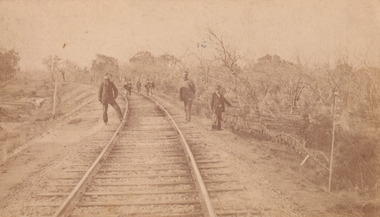 The Beechworth Burke Museum
Photograph - Carte de Visite, William E Barnes
This Carte-de-visite (CdV) taken by renowned Wangaratta based photographer William Edward Barnes previously belonged to the donor's grandfather, Daniel Mullins who was a Police Officer stationed at Glenrowan soon after the Kelly gang siege. Today, the siege has become an important part of Australian culture and Ned Kelly and the Kelly Gang (comprising of Ned Kelly, Dan Kelly, Steve Hart and Joe Byrne) has become ingrained in Australian history and mythology. A CdV is a sepia toned photograph mounted on card and is generally of a small size. This particular style was first patented by Andre Adolphe Eugene Disdéri (1819-1889) in 1854. In 1857, the CdV was introduced to England and after photographs of Queen Victoria, Prince Albert and their family were taken using CdV in 1860 the popularity of this method reached a peak. In this photograph, eight men stand along the railway line near Glenrowan. The photo dates to shortly after 1880 and references the attempt by the Kelly gang to derail a police train in June 1880 on those very tracks. Ultimately, this plan failed and the police train was never derailed. Ned Kelly and the Kelly gang took their final stand at Glenrowan which has been immortalised through Australian popular culture.This photograph is part of the Burke Museum "Kelly album" which includes a significant collection of photographs and artefacts connected to Ned Kelly and the Kelly Gang. Ned Kelly and his gang have become ingrained in Australian popular culture and thus many museums, art galleries and private collections house material connected to the Kelly story which allows the events and people to be researched and interpreted. Artefacts and photographs pertaining to the Kelly gang are particularly valuable for Australian museums. This particular photograph is significant for its connection to Wangaratta based photographer William Edward Barnes and to the Glenrowan Siege of June 1880. Taken at an unknown time, after the siege at Glenrowan, this image depicts eight gentlemen standing about the railway line near Glenrowan. This is a reference to the Kelly gang's plan to derail a train which would barrel up to Glenrowan after news reached Melbourne that Aaron Sherritt had been shot by Joe Byrne in the Woolshed Valley. This image is important for its artistic information that it can provide about the Kelly story and the fashion and streetscape of Glenrowan.This sepia coloured Carte de Visite is attached to yellow cardboard. The obverse of the photo depicts the railway line near Glenrowan around 1880s. The rails are positioned in the centre of the image and are made on an incline of earth. In the foreground are three men, two standing next to the rails and one slightly off to the right of the image. In the background are trees which line the side of the rails and slightly in front of these trees is a group of five men standing on the rails. The reverse of the image is yellow card and contains printed and pencil writing. The printed writing is in the centre of the card. It reveals that the photographer was William E Barnes from Wangaratta. The pencil writing provides the inscription stating that the photo was taken near Glenrowan around the time of Ned Kelly.Pencil: Railway line near / Glen Rowan / Kelly's time / Printed: W. E. Barnes / Photographer / Wangaratta / BMM 8089 /kelly album, glenrowan, glenrowan siege, carte-de-visite, glenrowan railway, ned kelly, kelly gang, last stand, colonial australia, kelly siege, train, railway line, railway, sepia, photography, william e barnes, william barnes -
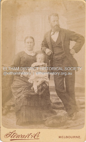
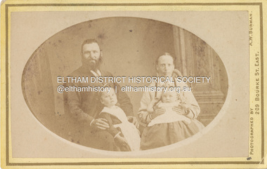 Eltham District Historical Society Inc
Photograph, A.W. Burman, Phillip and Sarah Ann Shillinglaw (nee Kidd) and children, c.1878-1879
Photographer: A.W. Burman, Artist Photographer, 209 Bourke Street East, Melbourne According to Sands & McDougall Melbourne Directory, Arthur W. Burman was active 209 Bourke St East, Melbourne from 1878 to circa 1885-1890 Sarah’s hairstyle is late 1870s/early 1880s . The children could possibly be Sarah Ann Shillinglaw (1873-1878) and Caroline Shillinglaw (1876-1956) which would date the photo early 1878 or Caroline Shillinglaw (1876-1956) and William Shillinglaw (1877-1891) which would date the photo early 1879 as Sarah was pregnant with Elizabeth Ann Shillinglaw who was born Aug 1879.. Daughter Jane Shillinglaw (1876-1876) had died prior to the date of this image. CARTE-DE-VISITE (cdv) 1857-1890 Cartes-de-visite (cdv's) are the most common form of photograph from the nineteenth century, generally measuring two and a half inches by four and an eighth inches (6.3 x 10.5 cm) when mounted, sepia toned, mounted on a card which was generally printed with the photographer's name and address on the back or beneath the portrait. - Frost, Lenore; Dating Family Photos 1850-1920; Valiant Press Pty. Ltd., Berwick, Victoria 19911878-1885, 1879, a.w. burman photographer 209 bourke st east, marg ball collection, phillip shillinglaw (1842-1914), sarah ann shillinglaw (1873-1878), sarah ann shillinglaw (nee kidd) (1850-1891), shillinglaw family photo album 1 -
 Eltham District Historical Society Inc
Photograph, Stewart & Co, Charles and Sarah (nee Shillinglaw) Aldous with either Florence May (1883) or Elizabeth Annie (1885) Aldous, c.1884-c.1887
Florence May Aldous was born 1883, her sister Elizabeth Annie was born 1 Nov. 1885 A duplicate image is contained in Album 2 (05664) Aldous family assumption was that the child was Elizabeth Annie. However upon further investigation with the original source of information written on back of a duplicate photo has confirmed in Annies hand it says “my mother and father”. Given that photo was handed down Elizabeth Annie's line, it is a reasonable presumption to have thought the child was Elizabeth Annie however it begs to question why her elder sister by two years is not in the photo. Hence it is thought the child is more likely to be Florence May. c.1885 Stewart & Co Photographers operated from various addresses in Bourke Street, Melbourne from 1871 through 1910. CARTE-DE-VISITE (cdv) 1857-1890 Cartes-de-visite (cdv's) are the most common form of photograph from the nineteenth century, generally measuring two and a half inches by four and an eighth inches (6.3 x 10.5 cm) when mounted, sepia toned, mounted on a card which was generally printed with the photographer's name and address on the back or beneath the portrait. - Frost, Lenore; Dating Family Photos 1850-1920; Valiant Press Pty. Ltd., Berwick, Victoria 1991marg ball collection, shillinglaw family photo album 1, 1884-1887, charles aldous, elizabeth annie aldous, florence may aldous, sarah aldous (nee shillinglaw 1854-1925), stewart & co photographers bourke st east melbourne, 1871-1910, 1885 -
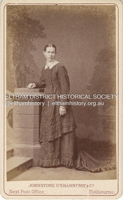 Eltham District Historical Society Inc
Photograph, Johnstone O'Shannessy & Co, Possibly Caroline Fairlie Stewart (nee Kidd) shortly after her marriage to Alexander Stewart, c.1885
In this image the woman appears wearing a thick wedding band on her left hand. She has a similar resemblance to Sarah Ann Shillinglaw (nee Kidd) and could possibly be a sister. The only sister that the timeline would fit would be Caroline Fairlie Kidd who married Alexander Kirk Stewart 7 Apr 1885 at Richmond, Victoria. The family then lived at Diamond Creek. Johnstone O'Shannessy & Co Photographers operated from 3 Bourke Street from approximately 1865 through 1885. By 1890 they had relocated to 234 Collins Street.The dress is less tailor made and form fitted which appeared from the mid 1880s suggesting this image is circa 1880-1885. There are two other copies of this image in Album 1 (05663) and three in Album 2 (05664) CARTE-DE-VISITE (cdv) 1857-1890 Cartes-de-visite (cdv's) are the most common form of photograph from the nineteenth century, generally measuring two and a half inches by four and an eighth inches (6.3 x 10.5 cm) when mounted, sepia toned, mounted on a card which was generally printed with the photographer's name and address on the back or beneath the portrait. - Frost, Lenore; Dating Family Photos 1850-1920; Valiant Press Pty. Ltd., Berwick, Victoria 1991a.w. burman photographer 209 bourke st east, marg ball collection, shillinglaw family photo album 1, 1865-1886, 1885, caroline fairlie stewart (nee kidd), johnstone o'shannessy & co photographers 3 bourke st melbourne, unknown -
 Eltham District Historical Society Inc
Photograph, Samuel Shillinglaw and family, possibly at Benalla, c.1882
Believed to be L-R: Arthur Samuel (1878-1907), Agnes Shillinglaw (nee McIntosh 1852-1931) with Agnes Mary (1881-1968), Samuel Shillinglaw (1848-1925). At the time of the birth of Arthur Samuel in 1878, Samuel was resident at Benalla, Victoria. Subsequent to this photo, Samuel and Agnes had three further daughters, Barbara Ethel (1884-1898), Lilian Muriel (1887-1939) and Elsie Gladys (1890-1891) Margaret Ball's 2018 book, Shillinglaw Family of Eltham 1660-2007 suggests (page 79) that Arthur Samuel later changed his name to Arthur Ernest to avoid the initials ASS Another copy of same photo in Album 2 is Inscribed on reverse:"For Grandma from Sam" No photographer details CARTE-DE-VISITE (cdv) 1857-1890 Cartes-de-visite (cdv's) are the most common form of photograph from the nineteenth century, generally measuring two and a half inches by four and an eighth inches (6.3 x 10.5 cm) when mounted, sepia toned, mounted on a card which was generally printed with the photographer's name and address on the back or beneath the portrait. - Frost, Lenore; Dating Family Photos 1850-1920; Valiant Press Pty. Ltd., Berwick, Victoria 1991marg ball collection, shillinglaw family photo album 1, 1882, agnes mary shillinglaw 1881-1968, agnes shillinglaw (nee mcintosh), arthur ernest shillinglaw, arthur samuel shillinglaw, benalla, house, samuel shillinglaw (1848-1925) -
 Eltham District Historical Society Inc
Photograph, Davies & Co, Believed to be Sarah Shillinglaw, c.1869
Sarah Shillinglaw was born at River Plenty on November 9, 1854. She married Charles Aldous on June 9, 1880 and died in Prahran, Victoria on August 3, 1925. Davies & Co (William Davies) operated from: 7 Bourke Street East 1867-1869 55 Bourke Street East 1874-1877 55 Bourke Street East as Central Photogrphic Studio (E. Sands Mgr) 1878-1884 73 Bourke Street East 1877 91 Bourke Street East 1864-1868 94 Bourke Street East 1864-1877 98 Bourke Street East 1860-1861 19 Collins Street East 1865-1868 5 Collins Street West 1866-1870 CARTE-DE-VISITE (cdv) 1857-1890 Cartes-de-visite (cdv's) are the most common form of photograph from the nineteenth century, generally measuring two and a half inches by four and an eighth inches (6.3 x 10.5 cm) when mounted, sepia toned, mounted on a card which was generally printed with the photographer's name and address on the back or beneath the portrait. - Frost, Lenore; Dating Family Photos 1850-1920; Valiant Press Pty. Ltd., Berwick, Victoria 1991marg ball collection, 1867-1869, 1869, davies & co post office photographic studio 7 bourke st east melbourne, paletot jacket, post office photographic studio, sarah aldous (nee shillinglaw 1854-1925), shillinglaw family photo album 2, unknown -
 Federation University Historical Collection
Plan, Burrumbeep, 1884, 16/10/1884
Auctions of Crown land were introduced in the Colony of Victoria from 1851 to encourage settlers to occupy and work the land. Many squatters purchased land at auction at the upset (minimum) price of £1 per acre. In some areas where demand was high, such as the goldfields, the price realised at auction was much more. Land was put up for sale in the study area on the Burrumbeep run in May 1855, on the Lexington run in 1857, and on the Gorrinn run in 1858. (http://www.ararat.vic.gov.au/library/document/thermatics.pdf, accessed 27 January 2015) For 70 years or more, Yalla-y-Poora, Burrumbeep, Edgarley, Mount William and Narrapumelap ranked in the leading wool producers in Victoria. 1 Stud owners at Yalla-y-Poora, Eurambeen, Burrumbeep and Challicum crossed merino sheep with sheep descended from John Macarthur's Camden Park in New South Wales. (http://www.ararat.vic.gov.au/library/document/thermatics.pdf, accessed 27 January 2015) In what was to become the Ararat Mining Division, gold was discovered in May 1854 on the Burrumbeep run at a place that became known as Pinky Point on the Mount William goldfield. By 21 June 1854, between 600 and 1,000 people had arrived. (http://www.ararat.vic.gov.au/library/document/thermatics.pdf, accessed 27 January 2015)\ Town allotment plan for Burrumbeep. Merrymbuela, Borung, Lexington and Langi Logan are neighbouring areas. The plan includes the Burrumbeep Pre-Emptive Right (Roger and Wright); licensed land holders including Stephen Young, John Carroll, William Walsh, Thomas Purcell, Martha M. Bond, Colin Johnson, John Charles Webb, Henry Withycombe, William Henry Barbridge, John Wall, Thomas Flatelly, William Jenkinson, Elisia Radford, V. Radford, Denis Byrne, George Cook. Land holders included Andrew Maloney, Richard Wingfield Harrocks, W. Sporton, Terence Lynch, F. S. Falkiner, A. Millman, H. Morris, George Upham, J. McCLure, S. Fletcher, W. Parker, Thomas Myers, William wright, W.C. Winter, C. Wordman, Oliver A. Winter This plan is associated with former Ballarat School of Mines student Richard Squire (1875-6) Gift of the Squire FamilyVerso written in pencil - Plan of Burrembeep Ararat Burrembeep Araratburrumbeep, corrinn, langi logan, merrymbuela, lexington, ararat, roger & wright, cook, rogers, upham, george upham, ross, parsans, morris, johnson, withycoombe, colin johnson, falkiner, dsporton, john carroll, donald gordon, denis bryne, maurice dooley, martha bond, william harricks, \william wingfield harricks, william l.c. harricks, michael houlihan, thomas purcell, martin ryan, michael cody, fletcher, mccaw, w. parker, j.m. clow, elisia radford, thomas radford, thomas myers, barbridge, e. wilde, j. wall, flatelly, g. wardman, w.c. winter, david ball, jenkinson, ballarat school of mines, richard squire, squire -
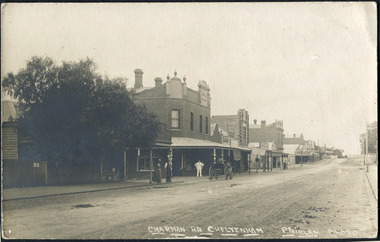 City of Moorabbin Historical Society (Operating the Box Cottage Museum)
Photographs , Postcards x4 Charman Rd Cheltenham c 1910, c1910
After the arrival of the Cheltenham Railyway Station Charman Road became the main shopping centre. From 1 small shop - Mrs Meeres who sold sweets, school requisites and drapery - it proceeded to develop throughout the 1890's with various traders until the 1910 Postcards show many shops on both sides of the road, Stephen Charman, aged 21years, arrived in Melbourne in 1842 as one of Henry Dendy's Emigrants. 1852 he purchased 160 acres for £328 bounded by Charman Rd and Balcome Rd. 'The Spring' was an important water source for the local Aboriginal people and then for the early settlers. Charman's first wife Harriet and their infant child died and in 1850 he married a widow with 5 children, Mary Gettens. Their first home was made of wattle and daub and they had 7 more children. Later a weatherboard cottage was built c 1855 Together they developed a market garden and specialized in marigolds which were sold for medicinal purposes to the Melbourne Chemists - Martin & Pleasance . The first Methodist Church Services were held at Spring Grove and the Charmans donated land in 1857 for the first Chapel, Cemetery and Primary School . Mary died 1870 and Stephen married again and moved to Gippsland where he died aged 85 in 1906 Stephen and Mary Charman were pioneer market gardeners in Moorabbin Shire 1842 and were involved in the development of Church, school and community in the area now called Cheltenham. Charman Road Cheltenham was a boundary of their land.4x Black & White Postcards c 1910 of Charman Road Cheltenham VictoriaFront; CHARMAN RD. CHELTENHAM P. FAIRLAM PHOTOfairlam p, cheltenham railway station, moorabbin, cheltenham, dendy henry, dendy's special survey 1841, assisted emigrants early settlers, pioneers, market gardeners, marigold flowers, pharmacy, charman stephen, gettens mary, charman harriet, methodist church, primitive methodists, box william, box elizabeth, state schools, education, moorabbin shire, moorabbin roads board, city of moorabbin, kingston city council, cancel, cheltenham primary school -
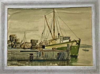 Queenscliffe Maritime Museum
Painting - Framed Watercolour, Fishermen's Pier Queenscliff
Queenscliff’s first pier, then known as the Fishermen’s Pier, was completed in 1857. It was not until some thirty years later that the second Steamer Pier was constructed adjacent to the former and periodically extended from the mid to late 1880s to cope with the demand in pleasure bay steamer services. The last of these extensions was to provide a dog-leg construction and the extant shelter shed. 1960 witnessed the demolition of the original Fishermen’s Pier - by this time having been extended in the late nineteenth and early twentieth centuries to the equivalent length of the Steamer Pier - and saw the relocation of its 1926-29 lifeboat house to the Steamer Pier, now Queenscliff Pier. The mid to late 2000s saw Queenscliff Harbour undergo large-scale redevelopment in order to deepen its waters for pleasure craft and increase its berths to over 300. This was met with strong community opposition, largely with concerns for neighbourhood character and perceived cause for gentrification its stakeholders would impart. With early construction estimates of $20 million dollars, this figure had almost doubled upon realisation. (Lovell Chen Architects. ‘Individual Property Citation’, Queenscliffe Heritage Study, 2009.) (Freya Mitchell, ‘Queenscliff residents fight a tide of development sweeping the historic town’ ABC radio, 15 April 2005).Fishermen's Pier Watercolour painting of Fishermen's Pier in Queenscliffwatercolour, fishermen's pier, queenscliff -
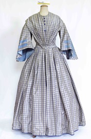 Brighton Historical Society
Clothing - Dress, Day dress, circa 1849
This dress was made for and belonged to Mrs Elizabeth McLachlan (nee Duncan, 1820-1904), wife of Reverend John Hamilton McLachlan (1813-1908), who was the first Minister of St Cuthbert's Presbyterian Church in Brighton. Elizabeth and John were married at the Free Church of Ayr at Lindsaystonn in the Parish of Kirkmickach, Ayrshire, Scotland on 15 October 1849. At this time his occupation was listed as "Minister of Presbyterian Church" and hers as "Governess". They left for Australia on the 1 November 1849 and arrived in Australia 6 months later. Apparently John's hair turned snow white during the journey due to his seasickness! The McLachlans first went to Geelong upon their arrival in 1850, then to the Western District, then Brighton, then Talbot at the height of the gold mining era. The couple had seven children: John Campbell Duncan McLachlan (b. Geelong, October 1850), Mary McLachlan (b. Geelong, November 1851), Agnes McLachlan (b. Hopkins River near Wickliff, May 1853), twins Elizabeth and Walter McLachlan (b. June 1854), Elizabeth McLachlan (b. Hesham, June 1855), Margaret McLachlan (b. Brighton, 1857). Elizabeth died in 1904. She and John are both buried in Amherst Cemetery. The dress was donated by one of her granddaughters. This circa 1849 silk blue grey window pane check dress features a high round neck and pleats on either shoulder extending over the natural shoulder line. The dress shows evidence of nine ornamental buttons down the centre front with only four blue silk buttons currently still attached. The dress fastens with thirteen concealed hook and eye closures to the waist. The Pagoda sleeves inset into the bodice in a small high armhole flaring out and finishing just below the elbow. A pale blue silk ribbon with a diagonal drawn stitch design decorates the front of the sleeve in a simple geometric design. The Pagoda sleeve is lined in a matching pale blue silk. The full skirt is pleated into the waistband and finishes just above the floor at the front. At the back the bodice features a squared off design to the princess panels shaping the dress into the body. The skirt is heavily pleated at the centre back into the waistline and finishes slightly longer at the back than the front. The skirt features two very small pockets on either side of the dress, just inside the hips. reverend john hamilton mclachlan, st cuthberts presbyterian church brighton, elizabeth mclachlan, amherst cemetery, 1840s fashion, brighton -
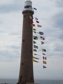 Parks Victoria - Gabo Island Lightstation
Flags & Pennants, navigational, signal
The 41 alphabetic and numeric visual signalling flags (including substitute and answering pennants) have either square or pointed ends. They are made of bunting, a coarse fabric of worsted (open yarn wool) in various colour combinations. Some of the flags are marked with inscriptions, for example “B”. Attachments to the flags include hemp rope and metal clips. Each flag has its own galvanised canister and lid, each of which is painted grey and marked with a letter, number or word. The flags were used for communicating messages to passing ships. Knowledge of visual signalling was mandatory for all lightkeepers and all lightstations maintained a set of flags. Although used for centuries, visual flag signalling formally developed in the nineteenth century and was published internationally as a system in 1857. By the early twentieth century it had developed into an effective means of conveying all kinds of short range visual messages. The signal flags and canisters at Gabo Island form a complete set and are not historically linked to the lightstation and their provenance is unknown. It is known however that they originate from a lightstation in Victoria and for some years were on loan from AMSA to the Queenscliff Maritime Museum, where they were held in storage and not displayed. Three of the six lightstations that Parks Victoria manages have sets of signal flags in their collections. Forty navigational signal alphabet flags & numeral pennants. Flags are made of wool. -
 Parks Victoria - Gabo Island Lightstation
Flag canisters
The 41 alphabetic and numeric visual signalling flags (including substitute and answering pennants) have either square or pointed ends. They are made of bunting, a coarse fabric of worsted (open yarn wool) in various colour combinations. Some of the flags are marked with inscriptions, for example “B”. Attachments to the flags include hemp rope and metal clips. Each flag has its own galvanised canister and lid, each of which is painted grey and marked with a letter, number or word. The flags were used for communicating messages to passing ships. Knowledge of visual signalling was mandatory for all lightkeepers and all lightstations maintained a set of flags. Although used for centuries, visual flag signalling formally developed in the nineteenth century and was published internationally as a system in 1857. By the early twentieth century it had developed into an effective means of conveying all kinds of short range visual messages. The signal flags and canisters at Gabo Island form a complete set and are not historically linked to the lightstation and their provenance is unknown. It is known however that they originate from a lightstation in Victoria and for some years were on loan from AMSA to the Queenscliff Maritime Museum, where they were held in storage and not displayed. In three of the six lightstations that Parks Victoria manages have sets of signal flags in their collections. Forty-one galvanised canisters with separate lids. The canisters are painted a grey/white colour and have either numbers, letters or words painted on the lid and on the cannister in black paint. There are variations in the style of canister and in the style of the inscriptions. -
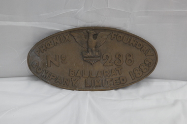 Puffing Billy Railway
Phoenix Foundry Plate
Phoenix Foundry Plate - replica Made about 2010 cast off original from locomotive Y112 The Phoenix Foundry (1857-1906) fabricated iron and brass products - including engines and pumping gear for the mining industry, locomotives, steam rollers, water pipes, water gauges and diverse small items. Throughout its operation the business was located at premises on Armstrong Street, Ballarat . Background In 1852, at the age of thirty-three and after a year of operating his own engineering business at Williamstown, Lancashire-born blacksmith and engineer George Threlfall (1819-1897) arrived on the Sebastopol gold plain and immediately undertook blacksmith work repairing picks and tools for the miners. Little did he know that this fledgling business would be the genesis of the most iconic business of nineteenth-century Ballarat. At approximately thirty-nine years of age, English mechanical engineer Richard Carter (c1814-1883) came to Australia on board the Arrogant - arriving in Melbourne on 19 April 1853. He soon travelled to the Ballarat goldfields. Born in the year 1830 in Belfast (Ireland), mechanical engineer William Henry Shaw (1830-1896) arrived in Australia in October 1853. He worked briefly with George Threlfall at Sebastopol, then moved to Geelong to manage the small foundry of Frederick Moore. Twenty-four year old English-born iron moulder Robert Holden (c1831-?) left his home in Belfast (Ireland) in late 1854 and travelled from Liverpool to Melbourne on board the James Baines - arriving in February 1855. Afterwards he joined his brother-in-law William Henry Shaw in Ballarat. History Foundation to Incorporation In March 1857 George Threlfall joined in business with Richard Carter, William Henry Shaw and Robert Holden. They relocated Threlfall's successful engineering enterprise from Sebastopol to new premises in Armstrong Street, Ballarat. This business was then known variously as the Phoenix Iron Works Company, Phoenix Foundry or Messrs Carter and Co. By 15 April 1857 they were advertising that they were open for business as engineers, millwrights, boiler makers, smiths, iron founders and brass founders. In January 1858 George Threlfall left the partnership. Incorporation to 1889 1890 to Closing locomotive Y112 Builder: Phoenix Foundry, Ballarat Builder’s Number & Year: 238 of 1889 Designer: Kitson & Co Wheel Arrangement: 0-6-0 No. in class: 31 Entered Service: 24 July 1889 Taken off Register: 11 May 1961 The origins of the Victorian Railways Y-class lay with the decision by Kitson & Co, Leeds to place a 0-6-0 freight locomotive on display at the Centennial International Exhibition, Melbourne in 1888, together with a 2-4-2T suburban passenger locomotive. This marketing initiative proved successful as the Victorian Railways were clearly impressed with these machines, with both purchased after the exhibition and becoming the patterns for new standard locomotive types. Thirty examples of the 0-6-0 heavy freight design were ordered from the Phoenix Foundry, Ballarat, becoming the Y-class for main line heavy freight duties, while the 2-4-2T design became the E-class for Melbourne suburban passenger duties (represented by preserved locomotive E 236). The Y-class prove successful in service and accrued high mileages. They were inevitably superseded by more modern and powerful steam locomotives and a number cascaded into shunting and yard pilot duties, often with the addition of shunters steps along both locomotive and tender. Y 112 was one of the last in service when withdrawn in 1961. Fortunately it was saved for preservation and plinthed in central Ballarat, ostensibly in commemoration of Phoenix Foundry. I understand it is owned by the Sovereign Hill Museums Association. During the 1980’s, Y 112 was leased to Steamrail Victoria and restored to operation at an industrial site in Ballarat. Y 112 features an attractive lined apple green livery and has performed various rail tours around Victoria since restoration. It is normally based at the Steamrail depot in Ballarat East. Y 112 is the only 19th century design in operational condition in Victoria and as such is one of the oldest working steam locomotive in Victoria . Historic - Phoenix Foundry Plate - replica Made about 2010 cast off original from locomotive Y112Phoenix Foundry Plate Oval shaped plate with an image of a phoenix centered at the top with lettering surrounding it.Phoenix Foundry No 238 Ballarat Company Limited 1889.puffing billy, phoenix foundry, ballarat, locomotive y112, phoenix foundry plate - replica -
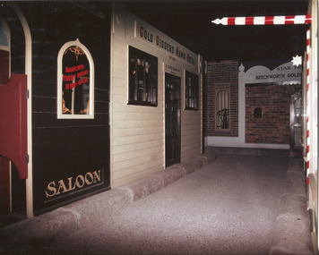 The Beechworth Burke Museum
Photograph, c1990
Taken in the 1990's, this photograph depicts a row of shop fronts in the 'Street of Shops' exhibition in the Burke Museum in Beechworth. This exhibition was created and opened in 1979 and was intended to reflect and imitate a historic peirod in the town's past. The time period decpicted is that of the Gold Rush which swept through many Victorian towns from the 1850's onwards. For the town of Beechworth, the gold rush began in 1852, when gold was discovered in Spring Creek, drawing in many new residents seeking to make a fortune and transforming a once remote town into a bustling centre brimming with hope and opportunity. By 1857, the town contained over 200,000 residents and with this, the need for more amenities and intsitutions arose. Multiple churches, banks, schools, shops, hospitals and other essential buildings appearing over the years. The wealth acquired through the gold rush is largely responsible for the vast development of the town and many of its significant buildings which still remain to this day. This photograph also highlights the significance of this type of exhibition, providing a new mode of experiencing and learning about the past. The street depicts the many supporting trades and industries that arose from the mass migration during the gold rush. The creation of the Street of Shops in 1979 was envisioned by Roy Harvey who was the curator at the time, with the intention of recreating an authentic feel to the environment while collecting from the community to accurately portray the multiculturalism that is ingrainded in many towns and communities of Victoria. This photograph contains historical significance as it relates to and portrays an especially important period of time within Beechworth and Victoria's history. The gold rush phenomena ushered in a wave of hope and prosperity for citizens and immigrants alike. It provided many with the opportunity to strike it rich, while the town prospered and grew in many ways. This widespread development that accompanied the gold rush occured throughout Victoria and holds great historical importance when recording the social, economic and communal developments that occured throughout the time period which gave way to the beloved towns and communities we know today. Beechworth itself is acknowledged as Victoria's best-preserved gold mining town and deserves recognition of its significance. it also showcases the great significance of social develpment and globalization that occured throughout the state during this period. Coloured rectangular photograph printed on matte photographic paper and unmounted. Obverse: Dancing every night 8pm-6am [mirror] / Gold Diggers Arms Hotel façade / Star / Beechworth Gold / J. Davidson / Saloon Reverse: 3306 beechworth, burke museum, street of shops, gold rush, indigo shire gold rush, 1850s beechworth, burke museum exhibitions, saloon, gold buyer, hotel, historical streetscape, gold rush immigration -
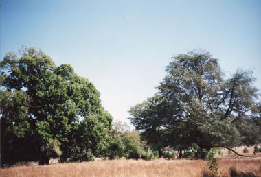 The Beechworth Burke Museum
Photograph, 2000
Woolshed is a small area about five kilometres north west of Beechworth, and almost about 225km north east of Melbourne. When gold was discovered at the nearby Spring Creek in February 1852, Woolshed was one of three settlements set up to house miners and their families. At its peak in 1857, Woolshed was also populated by 29 storekeepers and 14 hotels, as well as the Woolshed State School, which stood near where this photograph was taken. The school often played host to public meetings, as well as a public dance in 1897. The school was subject to some controversy in 1874 when one parent complained about the head of the school in the local newspaper, the Owens and Murray Advertiser, and at least three letters to the editor were exchanged between the two. According to the parent, C. O'Donoghue was not providing enough amusement for the children and was disrespectful to parents and staff. When the State Governor, Sir Reginald Talbot, visited Beechworth in 1906, the school organised a celebratory welcome. The Woolshed State School was ultimately closed in 1922 as miners had exhausted the Spring Creek gold supply and were moving elsewhere. This photograph, taken in about 2000, shows the trees that grew on or near the site of the original school. The Woolshed State School Honour Roll, with a list of the men from the school who served in the First World War, also still exists. It is stored in the Beechworth RSL as of 2015.This photograph is significant for its connection to an important site in Beechworth's gold mining history. Woolshed served a significant community of miners, with a population of at least 138 according to the 1911 census, with families that needed the school site to ensure their children's education. The image is also useful for prompting discussion about how Beechworth has changed over time, with the photograph taken 78 years after the school closed down.A colour rectangular photograph printed on glossy photographic paper.Woolshed State. / School site / 2000 / - remnant trees / / cobeechworth, burke museum, school, education, trees, nature, state school, woolshed, gold mining, teachers, over time, owens and murray advertiser, public meetings, public dance, c. o'donoghue, spring creek, state governor, sir reginald talbot, miners, honour roll, world war 1 -
 The Beechworth Burke Museum
Photograph - Carte de Visite, William E Barnes
In July of 1880, Ann Jones' successful hotel in Glenrowan burnt to the ground during the Kelly siege. She had opened her business in the year prior having been unsuccessful in her attempt to run a tea-room business in Wangaratta. The first building on this particular site was the home Ann Jones had built for herself and her family. Two years later she converted the home and added the hotel to the rear of the structure. One year later it was burnt to the ground. This image depicts the police station in 1882 on what would have been the site of Ann Jones' hotel. This Carte-de-viste (CdV) taken by renowned Wangaratta based photographer William Edward Barnes previously belonged to the donor's grandfather, Daniel Mullins who was a Police Officer stationed at Glenrowan soon after the Kelly gang siege. Today, the siege has become an important part of Australian culture and Ned Kelly and the Kelly Gang (comprising of Ned Kelly, Dan Kelly, Steve Hart and Joe Byrne) has become ingrained in Australian history and mythology. A CdV is a sepia toned photograph mounted on card and is generally of a small size. This particular style was first patented by Andre Adolphe Eugene Disdéri (1819-1889) in 1854. In 1857, the CdV was introduced to England and after photographs of Queen Victoria, Prince Albert and their family were taken using CdV in 1860 the popularity of this method reached a peak.This photograph is part of the Burke Museum "Kelly album" which includes a significant collection of photographs and artefacts connected to Ned Kelly and the Kelly Gang. Ned Kelly and his gang have become ingrained in Australian popular culture and thus many museums, art galleries and private collections house material connected to the Kelly story which allows the events and people to be researched and interpreted. Artefacts and photographs pertaining to the Kelly gang are particularly valuable for Australian museums. This particular photograph is significant for its connection to Wangaratta based photographer William Edward Barnes and to the Glenrowan Siege and Ann Jones' Hotel which burnt down during the siege in June 1880. Taken in 1882, this photograph has the opportunity to provide information about the townscape of Glenrowan shortly after the siege. It also provides important insight into the architecture and layout of the town. To the far right of the image, the photograph depicts the police station which was built on the site of Ann Jones' Hotel which can provide important information for the Kelly story and how the town evolved following 1880. It is also interesting to emphasise that the police station was built on the site of Ned Kelly and the Kelly gang's last stand.Sepia coloured photograph with a faded appearance. Image depicts four policemen with three standing and one sitting on a chair outside the Glenrowan police station. The station takes up the majority of the image and is placed in the centre of the photo. The four men are positioned on the left side of the station. The station is a large building with a gabled roof and extensions built into the veranda on either side. In between these extensions, the property has a white picket fence which runs from the extensions directly beneath the veranda enclosing the front of the structure. The letters 1, 2, 3, 4 are written on the yellow paper on which the image is situated and relate to the images in the photo. The reverse of the photo provides the names of each policeman and reveals the image as being from the collection of William E Barnes a Wangaratta based photographer.Obverse: 1. 2. 3. 4. Reverse: No. 1. is Mullins, D. G. / 2. Lord, Edward. / 3. Millar, Allex. / 4. Hedberg, O. G. / All Comrades / Glenrowan Police Station / 1 August 1882 / W. E. Barnes / Photographer / Wangaratta /kelly album, william barnes, wangaratta photographer, carte-de-viste, glenrowan, 1882, police station, ann jones inn, ann jones hotel, kelly siege, glenrowan siege, colonial australia, ned kelly, steve hart, joe byrne, william e barnes -
 Eltham District Historical Society Inc
Photograph, A.W. Burman, Sarah Shillinglaw, c.1880
Possibly photographed shortly before marriage to Charles Edward Aldous in June 1880. Sarah is not wearing a ring in this image. (Duplicate copy in Album 2 (05664) Photographer: A.W. Burman, Artist Photographer, 209 Bourke Street East, Melbourne According to Sands & McDougall Melbourne Directory, Arthur W. Burman was active 209 Bourke St East, Melbourne from 1878 to circa 1885-1890 Sarah’s hairstyle is late 1870s/early 1880s . The children could possibly be Sarah Ann Shillinglaw (1873-1878) and Caroline Shillinglaw (1876-1956) which would date the photo early 1878 or Caroline Shillinglaw (1876-1956) and William Shillinglaw (1877-1891) which would date the photo early 1879 as Sarah was pregnant with Elizabeth Ann Shillinglaw who was born Aug 1879.. Daughter Jane Shillinglaw (1876-1876) had died prior to the date of this image. CARTE-DE-VISITE (cdv) 1857-1890 Cartes-de-visite (cdv's) are the most common form of photograph from the nineteenth century, generally measuring two and a half inches by four and an eighth inches (6.3 x 10.5 cm) when mounted, sepia toned, mounted on a card which was generally printed with the photographer's name and address on the back or beneath the portrait. - Frost, Lenore; Dating Family Photos 1850-1920; Valiant Press Pty. Ltd., Berwick, Victoria 1991a.w. burman photographer 209 bourke st east, marg ball collection, shillinglaw family photo album 1, 1878-1885, 1880, sarah aldous (nee shillinglaw 1854-1925) -
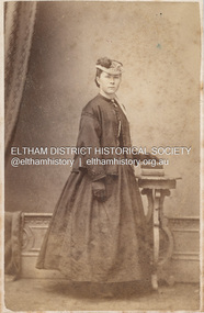
 Eltham District Historical Society Inc
Photograph, Stewart & Co, Sarah Aldous (nee Shillinglaw), c.1882
In this image Sarah appears young and has a wide wedding band on her left ring finger which dates it to after her marriage to Charles Aldous in June 1880. By the mid 1880s dresses were becoming more tailor made and form fitting. Hair in the 1880 was plainly dressed, close to the head, with a small bun in the early eighties, and a higher one from 1885 suggesting early 1880s for this image, shortly after her marriage. A duplicate image is located on page 27 of the album. Stewart & Co operated from 217 Bourke St., East from 1871 to 1876 and from 217-219 from 1877 to 1889. Other locations included 42, 284 and 286. Overall, they operated in Melbourne from 1871 through at least 1910 though Carte-de-Visite photos were superseded by 1890. CARTE-DE-VISITE (cdv) 1857-1890 Cartes-de-visite (cdv's) are the most common form of photograph from the nineteenth century, generally measuring two and a half inches by four and an eighth inches (6.3 x 10.5 cm) when mounted, sepia toned, mounted on a card which was generally printed with the photographer's name and address on the back or beneath the portrait. - Frost, Lenore; Dating Family Photos 1850-1920; Valiant Press Pty. Ltd., Berwick, Victoria 1991marg ball collection, shillinglaw family photo album 1, 1871-1890, 1882, sarah aldous (nee shillinglaw 1854-1925), stewart & co photographers melbourne