Showing 4410 items matching "ballarat heritage services"
-
 Ballarat Heritage Services
digital photographs, Lisa Gervasoni, Greensborough Pre Olympic Swimming Pool, c2010-2017
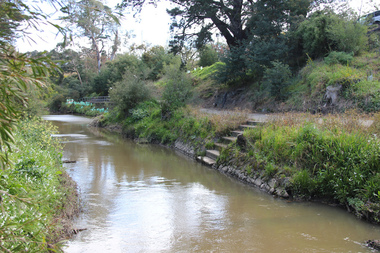
... Ballarat Heritage Services PO Box 2209 Bakery Hill Post ...Colour photograph of a stretch in the river where the Greensborough Swimming Pool was located. swimming pool, sport, swimming, pre olympic, natural, creek, greensborough, steps, greensborough swimming pool -
 Ballarat Heritage Services
digital photographs, Lisa Gervasoni, Pre-Olympic Swimming Pool at Kilmore, c2012, c2010-2017
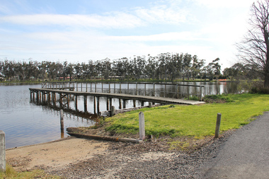
... Ballarat Heritage Services PO Box 2209 Bakery Hill Post ...There are many reports of early swimming holes in 19th Century Victoria. Between the period 1895 - 1920, most rural Councils were under pressure to provide more formalised bathing arrangements. Often this occurred through the building of wooden enclosures in rivers, the damming of creeks, the construction of lakes, or the utilisation of old pits for the purpose.Colour photograph of the site of the former Kilmore Pool, now a reservoir on the Kilmore Golf Club. swimming pool, sport, swimming, pre olympic, natural, lake, kilmore, pre-olympic -
 Ballarat Heritage Services
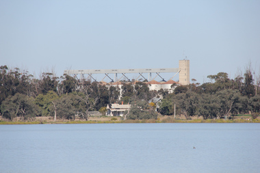
digital photographs, Lisa Gervasoni, Yarrawonga Pre Olympic Swimming Pool, c2010-2017
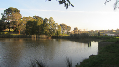
... Ballarat Heritage Services PO Box 2209 Bakery Hill Post ...Colour photograph of the Yarrawonga Pre Olympic Swimming Pool in the Murray River. swimming pool, sport, swimming, pre olympic, natural, lake, yarrawonga, murray river -
 Ballarat Heritage Services
Photograph - digital photographs, Lisa Gervasoni, Murtoa Pre Olympic Swimming Pool, c2010-2017
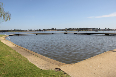
... Ballarat Heritage Services PO Box 2209 Bakery Hill Post ...Colour photograph of Murtoa Pre Olympic Swimming Pool.swimming pool, sport, swimming, pre olympic, natural, lake, murtoa, murtoa swimming pool, murtoa pre olympic swimming pool -
 Ballarat Heritage Services
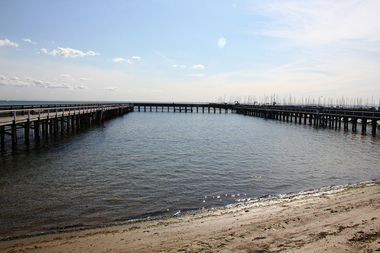
digital photographs, Lisa Gervasoni, Brighton Beach Pre Olympic Swimming Pool, c2015, c2010-2017
... Ballarat Heritage Services PO Box 2209 Bakery Hill Post ...Colour photograph of a swimming enclosure at Brighton Beach, Victoria.swimming pool, sport, swimming, pre olympic, natural, ocean, brighton, brighton beach swimming pool -
 Ballarat Heritage Services
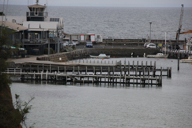
digital photographs, Lisa Gervasoni, Mornington Sea Baths (pre olympic pool), c2010-2017
... Ballarat Heritage Services PO Box 2209 Bakery Hill Post ...Colour photograph of the Mornington Sea Baths.swimming pool, sport, swimming, pre olympic, natural, ocean, mornington, mornington sea baths, mornington swimming pool -
 Ballarat Heritage Services
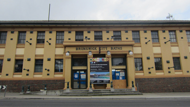
digital photographs, Lisa Gervasoni, Brunswick City Baths (pre olympic pool), c2010-2017
... Ballarat Heritage Services PO Box 2209 Bakery Hill Post ...Colour photograph of the Brunswick City Swimming Pool.swimming pool, sport, swimming, pre olympic, baths, brunswick, brunswick baths, brunswick swimming pool, pre olympic swiming pool -
 Ballarat Heritage Services
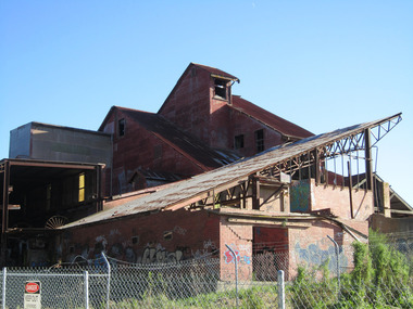
digital photographs, Lisa Gervasoni, Former Standard Brick Works, c2010-2017
... Ballarat Heritage Services PO Box 2209 Bakery Hill Post ...The site includes a Hoffman kiln, clay mill building, grinding pans and brick presses, relics of the downdraught kiln stack, office, former locomotive shed, and quarry.The buildings of a brickworks in Box Hill, Victoria.box hill, surrey, surrey drive, brickworks, factory, industrial heritage, ruin, standard brickworks -
 Ballarat Heritage Services
Photograph - digital photographs, Lisa Gervasoni, Boort silos, c2010-2017
... Ballarat Heritage Services PO Box 2209 Bakery Hill Post ...Colour photograph of the silos at Boort, Victoria.boort, silos, lake, boort silos -
 Ballarat Heritage Services
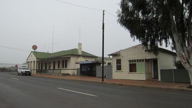
digital photographs, Lisa Gervasoni, Balmoral Hotel, c2010-2017
... Ballarat Heritage Services PO Box 2209 Bakery Hill Post ...balmoral, hotel -
 Ballarat Heritage Services
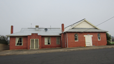
digital photographs, Lisa Gervasoni, Balmoral Hall, c2010-2017
... Ballarat Heritage Services PO Box 2209 Bakery Hill Post ...balmoral -
 Ballarat Heritage Services
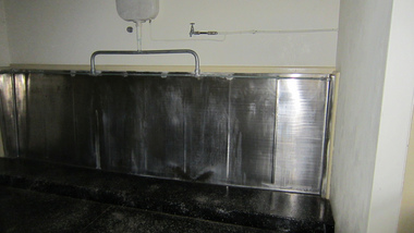
digital photographs, Lisa Gervasoni, urinals St Brigid's, c2010-2017
... Ballarat Heritage Services PO Box 2209 Bakery Hill Post ...crossley, st brigid's, urinal -
 Ballarat Heritage Services
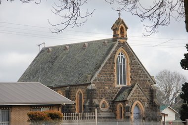
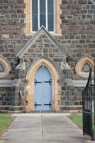
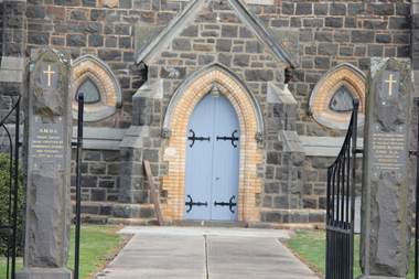
Photograph - Photograph - Colour, L.J. Gervasoni, Carisbrook Church of England, 06/08/2011
... Ballarat Heritage Services PO Box 2209 Bakery Hill Post ...The first Carisbrook Church of England services were held in a wooden building also used as the Common School. The current bluestone church was opened in 1866.Colour photograph of a bluestone church at Carisbrook.carisbrook, church, bluestone, carisbrook church of england, carisbrook.anglican church -
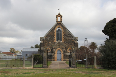 Ballarat Heritage Services
Photograph - Photograph - Colour, L.J. Gervasoni, St Paul's Anglican Church, Carisbrook, 2011, 06/08/2011
... Ballarat Heritage Services PO Box 2209 Bakery Hill Post ...Anglican services were first held in Carisbrook in 1851. In 1854 church services and a school were conducted in the Parish Hall. In 1864 - 1866 the blue stone church was erected. The interior was renovated in 1966 and the vestry was added in 1972. St Paul's Carisbrook was decommissioned in 2015, with the last service being held on 31 October 2015 after 149 years of worship.Colour photograph of a Church at Carisbrook, Victoria.carisbrook, church, st paul's anglican church carisbrook, carisbrook church of england -
 Ballarat Heritage Services
Photograph - Colour, L.J. Gervasoni, Carisbrook Church, 06/08/2011
... Ballarat Heritage Services PO Box 2209 Bakery Hill Post ...carisbrook, church -
 Ballarat Heritage Services
Photograph - Photograph - Colour, L.J. Gervasoni, Carisbrook Church, 06/08/2011
... Ballarat Heritage Services PO Box 2209 Bakery Hill Post ...Bluestonechurch in Carisbrookcarisbrook, church, carisbrook anglican church -
 Ballarat Heritage Services
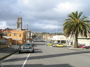
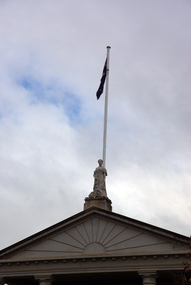
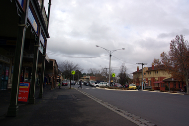
Photograph - Colour, L.J. Gervasoni, Castlemaine, 2004, 28/06/2004
... Ballarat Heritage Services PO Box 2209 Bakery Hill Post ...Colour photograph at Castlemaine, Victoria.castlemaine, castlemaine post office, palm tree -
 Ballarat Heritage Services
Photograph - Photograph - Colour, Castlemaine Bluestone Gutter, 2004, 28/06/2004
... Ballarat Heritage Services PO Box 2209 Bakery Hill Post ...Colour photograph of a bluestone gutter in Urquhart Street, Castlemaine.castlemaine, gutter, bluestone, infrasctructure -
 Ballarat Heritage Services
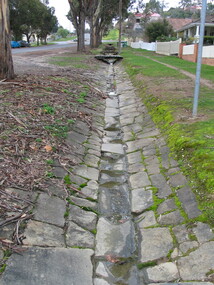
Photograph - Photograph - Colour, Castlemaine Bluestone Gutter, in Urquhart Street, 2004, 28/06/2004
... Ballarat Heritage Services PO Box 2209 Bakery Hill Post ...Many gutters in Castlemaine are deep and protected by bluestone. Colour photograph of a bluestone gutter in Urquhart Street, Castlemaine.castlemaine, gutter, bluestone, infrasctructure -
 Ballarat Heritage Services
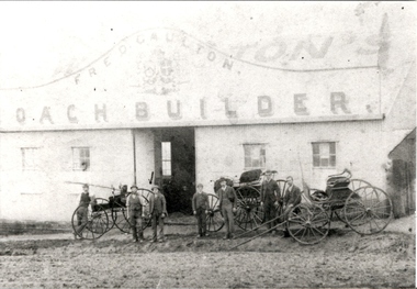
Photograph - Colour, Fred Gaulton Coach Builder Castlemaine
... Ballarat Heritage Services PO Box 2209 Bakery Hill Post ...Colour photograph of the facade of Fred Gaulton's Coach Builder in Castlemaine. On of the men out the front is a member of the Gervasoni family.castlemaine, fred gaulton, coach builder, gervasoni -
 Ballarat Heritage Services
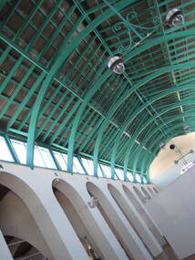
Photograph - Colour, Clare Gervasoni, Castlemaine Market Building
... Ballarat Heritage Services PO Box 2209 Bakery Hill Post ...castlemaine, castlemaine market building -
 Ballarat Heritage Services
Photograph - Colour, Clare Gervasoni, Castlemaine Market Building
... Ballarat Heritage Services PO Box 2209 Bakery Hill Post ...castlemaine, castlemaine market building -
 Ballarat Heritage Services
Photograph - Colour, Clare Gervasoni, Castlemaine Street
... Ballarat Heritage Services PO Box 2209 Bakery Hill Post ...castlemaine, castlemaine market building -
 Ballarat Heritage Services
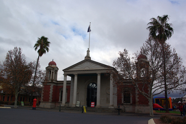
Photograph - Colour, Clare Gervasoni, Castlemaine Market Building, 2013, 04/03/2013
... Ballarat Heritage Services PO Box 2209 Bakery Hill Post ...castlemaine, castlemaine market building -
 Ballarat Heritage Services
Photograph - Colour, Earth Banks, Old Sarum, England, 2016, 01 November 2016
... Ballarat Heritage Services PO Box 2209 Bakery Hill Post ...William the Conqueror inherited Old Sarum from the last Saxon king of England. It was an ideal site for a royal castle. It was here in 1070 that William paid off his army after a long and bitter campaign in northern England. It was here in 1086 that he called together all the major landholders in England so they could swear allegiance to him. It was a crucial moment. The Domesday Book was being written, a threatened Viking invasion had only just been averted and William's eldest son was in armed rebellion. Old Sarum was an important place where this Norman king of England held power. In 1794 the Ordnance Survey set out to check the accuracy of the first mapping of Southern England, which had begun ten years earlier. From a point just below Old Sarum Lieutenant William Mudge laid out a base-line 36,574 feet (11,253 metres) long. From each end of the line the positions of distant places were plotted using a huge theodolite made in 1791 by Jesse Ramsden. The accuracy of the process, which was repeated all over England, depended on Jesse Ramsden's craftsmanship and on William Mudge's surveying skill in setting out this first base-line from Old Sarum. The nearer end of Mudge's line is marked by an inscribed stone beside the modern A345 at Old Sarum. ordnance survey, william mudge, jesse ramsden, william the conqueror, old sarum, saxon, 1086, england -
 Ballarat Heritage Services
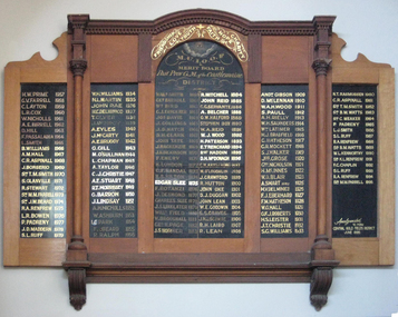
Photograph - Photograph - Colour, Clare Gervasoni, Honour Board in Castlemaine Market Building, 2013, 04/03/2013
... Ballarat Heritage Services PO Box 2209 Bakery Hill Post ...Colour photograph of the Castlemaine Manchester Unity Independent Order of Oddfellows Honour Board inside the Castlemaine market Building. castlemaine, castlemaine market building, castlemaine manchester unity independent -
 Ballarat Heritage Services
Photograph - Colour, Earth Banks, Old Sarum, England, 01 November 2016
... Ballarat Heritage Services PO Box 2209 Bakery Hill Post ...William the Conqueror inherited Old Sarum from the last Saxon king of England. It was an ideal site for a royal castle. It was here in 1070 that William paid off his army after a long and bitter campaign in northern England. It was here in 1086 that he called together all the major landholders in England so they could swear allegiance to him. It was a crucial moment. The Domesday Book was being written, a threatened Viking invasion had only just been averted and William's eldest son was in armed rebellion. Old Sarum was an important place where this Norman king of England held power. In 1794 the Ordnance Survey set out to check the accuracy of the first mapping of Southern England, which had begun ten years earlier. From a point just below Old Sarum Lieutenant William Mudge laid out a base-line 36,574 feet (11,253 metres) long. From each end of the line the positions of distant places were plotted using a huge theodolite made in 1791 by Jesse Ramsden. The accuracy of the process, which was repeated all over England, depended on Jesse Ramsden's craftsmanship and on William Mudge's surveying skill in setting out this first base-line from Old Sarum. The nearer end of Mudge's line is marked by an inscribed stone beside the modern A345 at Old Sarum. ordnance survey, william mudge, jesse ramsden, william the conqueror, old sarum, saxon, 1086, england -
 Ballarat Heritage Services
Photograph - Colour, Earth Banks, Old Sarum, England, 2016, 01 November 2016
... Ballarat Heritage Services PO Box 2209 Bakery Hill Post ...William the Conqueror inherited Old Sarum from the last Saxon king of England. It was an ideal site for a royal castle. It was here in 1070 that William paid off his army after a long and bitter campaign in northern England. It was here in 1086 that he called together all the major landholders in England so they could swear allegiance to him. It was a crucial moment. The Domesday Book was being written, a threatened Viking invasion had only just been averted and William's eldest son was in armed rebellion. Old Sarum was an important place where this Norman king of England held power. In 1794 the Ordnance Survey set out to check the accuracy of the first mapping of Southern England, which had begun ten years earlier. From a point just below Old Sarum Lieutenant William Mudge laid out a base-line 36,574 feet (11,253 metres) long. From each end of the line the positions of distant places were plotted using a huge theodolite made in 1791 by Jesse Ramsden. The accuracy of the process, which was repeated all over England, depended on Jesse Ramsden's craftsmanship and on William Mudge's surveying skill in setting out this first base-line from Old Sarum. The nearer end of Mudge's line is marked by an inscribed stone beside the modern A345 at Old Sarum. ordnance survey, william mudge, jesse ramsden, william the conqueror, old sarum, saxon, 1086, england -
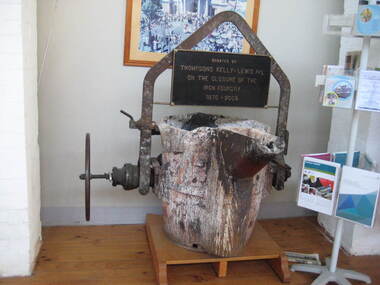 Ballarat Heritage Services
Photograph - Colour, Clare Gervasoni, Thompson's Foundry, 2013, 04/03/2013
... Ballarat Heritage Services PO Box 2209 Bakery Hill Post ...Colour photograph of a remnant from Thompson's Foundry inside the Castlemaine market Building. castlemaine, castlemaine market building, thompson's foundry -
 Ballarat Heritage Services
Photograph - Colour, Earth Banks, Old Sarum, England, 01 November 2016
... Ballarat Heritage Services PO Box 2209 Bakery Hill Post ...William the Conqueror inherited Old Sarum from the last Saxon king of England. It was an ideal site for a royal castle. It was here in 1070 that William paid off his army after a long and bitter campaign in northern England. It was here in 1086 that he called together all the major landholders in England so they could swear allegiance to him. It was a crucial moment. The Domesday Book was being written, a threatened Viking invasion had only just been averted and William's eldest son was in armed rebellion. Old Sarum was an important place where this Norman king of England held power. In 1794 the Ordnance Survey set out to check the accuracy of the first mapping of Southern England, which had begun ten years earlier. From a point just below Old Sarum Lieutenant William Mudge laid out a base-line 36,574 feet (11,253 metres) long. From each end of the line the positions of distant places were plotted using a huge theodolite made in 1791 by Jesse Ramsden. The accuracy of the process, which was repeated all over England, depended on Jesse Ramsden's craftsmanship and on William Mudge's surveying skill in setting out this first base-line from Old Sarum. The nearer end of Mudge's line is marked by an inscribed stone beside the modern A345 at Old Sarum. ordnance survey, william mudge, jesse ramsden, william the conqueror, old sarum, saxon, 1086, england