Showing 8376 items matching "bridge"
-
 The Beechworth Burke Museum Research Collection
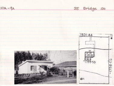
Card (Series) - Index Card, George Tibbits, 35 Bridge Street, Beechworth, 1976
George Tibbits, University of Melbourne. Faculty of Architecture, Building and Town & Regional PlanningIndex system that support the research for Beechworth : historical reconstruction / [by] George Tibbits ... [et al]Arranged by street names of BeechworthEach index card includes: street name and number of property, image of property, allotment and section number, property owners and dates of ownership, description of the property according to rate records, property floor plan with dimensions.beechworth, george tibbitsbeechworth, george tibbits -
 Ringwood and District Historical Society
Notes for book, Rogaughan, John, Material for History of Kilsyth, Croydon, Burnt Bridge and Ringwood (book never completed). By John Rogaughan (undated), not known
Collected for a history book of Kilsyth, Croydon, Burnt Bridge and Ringwood but never completed.27 pages of notes intended for a local history book typed with some connections. +Additional Keywords: Rogaughan, John -
 Eltham District Historical Society Inc
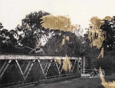
Album - Photograph, J.A. McDonald, Henley Road Bridge over Watsons Creek, Aug. 1962
Henley Road Bridge over Watsons Creek Eltham Abutment August 1962Record of various Shire of Eltham infrastructure works undertaken during the period of 1952-1962 involving bridge and road reconstruction projects, sometimes with Eltham Shire Council Project Reference numbers quoted. It was during this period that a number of significant improvements were made to roads and new bridges constructed within the shire that remain in place as of present day (2022). In many situations, the photos provide a tangible visible record of infrastructure that existed throughout the early days of the Shire. The album was put together by or under the direction of the Shire Engineer, J.A. McDonald.H941 stamped on reverse (film processing #)infrastructure, shire of eltham, bridge construction, road construction, bushfires, 1962-08, bend of islands, henley road, henley road bridge, kangaroo ground, oxley bridge, watsons creek -
 Eltham District Historical Society Inc
Album - Photograph, J.A. McDonald, Henley Road Bridge over Watsons Creek, Sep. 1962
Henley Road Bridge over Watsons Creek Eltham Abutment September 1962Record of various Shire of Eltham infrastructure works undertaken during the period of 1952-1962 involving bridge and road reconstruction projects, sometimes with Eltham Shire Council Project Reference numbers quoted. It was during this period that a number of significant improvements were made to roads and new bridges constructed within the shire that remain in place as of present day (2022). In many situations, the photos provide a tangible visible record of infrastructure that existed throughout the early days of the Shire. The album was put together by or under the direction of the Shire Engineer, J.A. McDonald.H941 stamped on reverse (film processing #)infrastructure, shire of eltham, bridge construction, road construction, bushfires, bend of islands, henley road, henley road bridge, kangaroo ground, oxley bridge, watsons creek, 1962-09 -
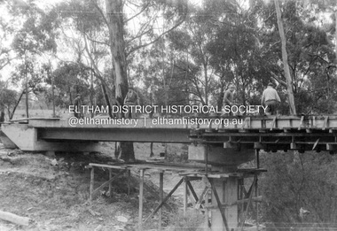
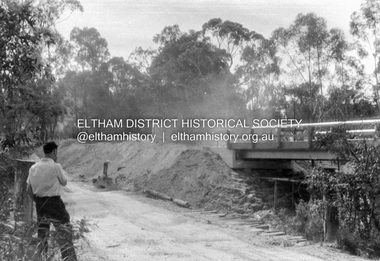
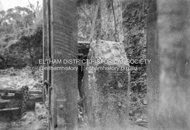 Eltham District Historical Society Inc
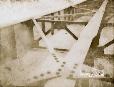
Album - Photograph, J.A. McDonald, Dixons Creek Bridge, c. 1962
Dixons Creel Bridge Broken head of pile View looking upstream ? eastRecord of various Shire of Eltham infrastructure works undertaken during the period of 1952-1962 involving bridge and road reconstruction projects, sometimes with Eltham Shire Council Project Reference numbers quoted. It was during this period that a number of significant improvements were made to roads and new bridges constructed within the shire that remain in place as of present day (2022). In many situations, the photos provide a tangible visible record of infrastructure that existed throughout the early days of the Shire. The album was put together by or under the direction of the Shire Engineer, J.A. McDonald.'66' written in pencil1962, bridge construction, dixons creek bridge, dixon's creek road, infrastructure, road construction, shire of eltham -
 Greensborough Historical Society
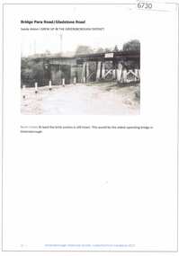
Article and Photograph, Bridge at Para Road and Gladstone Road, 2018_
Information and photograph about the railway bridge at Para Road and Gladstone Road Greensborough.This photograph and text was copied from a Facebook site. Members are people who lived in the Greensborough area and share their reminiscences of the area with others. The site is administered by a GHS member but is not officially affiliated with the Society. Any information is the opinion of the contributor. Article and photograph sourced from social media.railway bridge greensborough, gladstone road briar hill, para road greensborough -
 Greensborough Historical Society
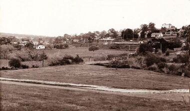
Photograph - Digital image, Jan Lewis, From Sondemeyer's looking towards swing bridge and Pope's farm, circa 1958, 1958c
From Sondemeyer's looking towards swing bridge and Pope's farm, circa 1958Digital copy of black and white photographsondemeyers hill, popes farm -
 Greensborough Historical Society
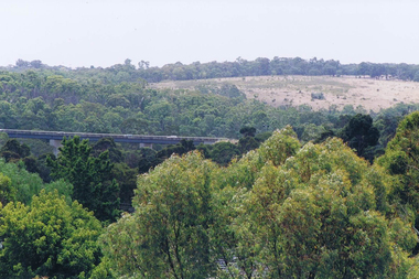
Photograph - Digital image, Frank Solomon, View over Greensborough to Plenty River Drive bridge, 2010c
View over trees to the Greensborough By-pass bridge over Plenty River Drive.Digital copy of colour photographplenty river drive, greensborough bypass -
 Stawell Historical Society Inc
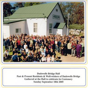
Photograph, Spielvogel Photographic, Dadswells Bridge Hall
Colour photo of Dadswells Bridge building and gathering of people for centenary of Hall. 2005Colour photo in Folder -
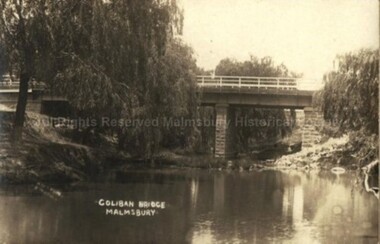 Malmsbury Historical Society
Postcard (Item), "Postcard Of Coliban Bridge At Malmsbury, Kodak Postcard", Malmsbury c1912
Associated with - Kodak Postcard See 1pcd0006r Buildings - Bridge People - Sutton Photo -
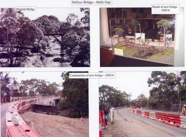 Stawell Historical Society Inc
Photograph, Delley's Bridge in Hall’s Gap during construction in 2005-2006 -- 4 Photos -- Coloured
Four photographs showing Construction of Delley's Bridge Hall’s Gap 2005-2006stawell -
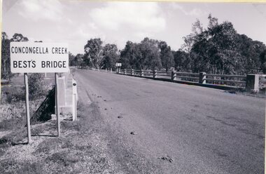 Stawell Historical Society Inc
Photograph, Best’s Bridge over Concongella Creek in Great Western with plaques -- 3 Photos
Three photographs of Best’s Bridge over Concongella Creek. Great Western with plaques.stawell -
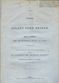 Warrnambool and District Historical Society Inc.
Document, Allan’s Ford Bridge 1852, 1852
This is an original Victorian Government document containing the printed version of 37 reports and letters regarding the building of the first Allansford bridge completed early in 1852. The correspondence dates from October 1850 to February 1852 and includes letters and reports from Melbourne Government employees such as Robert Hoddle, Chief Surveyor, David Lennox, Superintendent of Bridges and Lieutenant – Governor Charles La Trobe. The correspondence from local settlers included the names of William and John Allan, John Davidson and James Coulstock. The correspondence shows that some settlers in the Warrnambool/Port Fairy district wanted a portion of the Government allocated funds spent on the local roads and bridges in other locations. The 1852 Allansford bridge cost £480 and was replaced in 1870. This document has strong historical significance as it relates to one of the earliest State government works in the district and records the public imput into the decision.. It contains opinions and correspondence between a number of early settlers in the district at the time.Grey/blue paper document with black text. 21 pages plus 4 page index at back.allan's ford 1852, allansford bridge, allansford, history of allansford, warrnambool -
 Eltham District Historical Society Inc
Photograph, Parsons Road Bridge over Maroondah Aqueduct near Margaret Street, Eltham, 1991
Colour photographmaroondah aqueduct, aqueduct, bridge, eltham, parsons road, margaret street -
 Eltham District Historical Society Inc
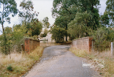
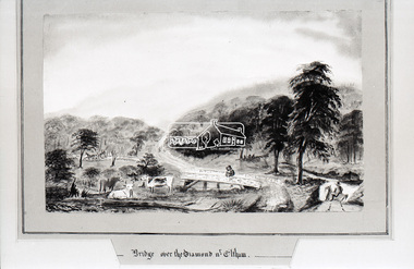
Photograph, Daniel Rutter Long, Bridge over the Diamond near Eltham, Daniel Rutter Long, 1855
Daniel Rutter Long was born in England, after training as a pharmacist he, his wife and family emigrated to Port Phillip, Victoria in 1840. By 1843 he had his own chemist shop in Bourke Street, later erecting a well known pharmacy on the corner of Bourke and Exhibition streets. During the gold rush of the 1850s he purchased gold at the shop for shipment to a Quaker syndicate in London. Retiring from the business in 1857 Long took up painting, sometimes returning to his original profession. He painted hundreds of landscapes in other colonies as well as in Victoria. Long participated in local affairs and was one of the earliest members of the municipal council. Later he was elected mayor and instrumental in the in the erection of Prahran Town Hall. He was also a member of the Police Court Bench for many years. Daniel Long died at the age of eighty-three in 1886. (State Library of Victoria)This photo forms part of a collection of photographs gathered by the Shire of Eltham for their centenary project book,"Pioneers and Painters: 100 years of the Shire of Eltham" by Alan Marshall (1971). The collection of over 500 images is held in partnership between Eltham District Historical Society and Yarra Plenty Regional Library (Eltham Library) and is now formally known as the 'The Shire of Eltham Pioneers Photograph Collection.' It is significant in being the first community sourced collection representing the places and people of the Shire's first one hundred years.Digital image 35mm B&W negativeshire of eltham pioneers photograph collection, bridge, daniel rutter long, diamond creek (creek), eltham, sepp -
 Eltham District Historical Society Inc
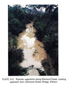
Work on paper (Sub-Item) - Photograph, Riparian vegetation along Diamond Creek. Looking upstream from Diamond Street Bridge, Eltham
Colour photograph of a muddy creek (probably after a downpour) with plants growing on the water's edge along both banks of the creek, including trees, shrubs, grasses and vines. eltham, creek, vegetation, diamond street, bridge, diamond creek -
 Eltham District Historical Society Inc
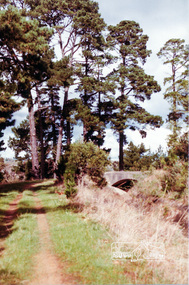
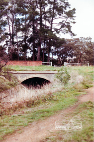
Photograph, Ingrams Road Bridge over Aqueduct, Research
Colour photographmaroondah aqueduct, aqueduct, bridge, ingrams road, research (vic.), scan - 35mm negative -
 Eltham District Historical Society Inc
Photograph, Ingrams Road Bridge over Aqueduct, Research
Colour photographmaroondah aqueduct, aqueduct, bridge, ingrams road, research (vic.), scan - 35mm negative -
 Eltham District Historical Society Inc
Photograph, Ingrams Road Bridge over Aqueduct, Research
Colour photographmaroondah aqueduct, aqueduct, bridge, ingrams road, research (vic.), scan - 35mm negative -
 Eltham District Historical Society Inc
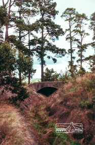
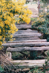
Photograph, Richard Pinn, Bridge over Diamond Creek, Murray's property, Eltham, c.1983
Footbridge over the Diamond Creek near Murray's Flats in a bad state of repair in the early 1980sColour photograph printeltham, bridges, diamond creek, murray, bridge, murrays bridge -
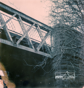
 Eltham District Historical Society Inc
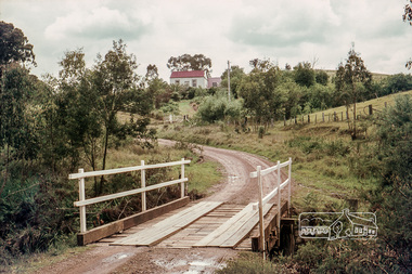
Photograph, Russell Yeoman, Long Gully Road Bridge over Long Gully at Panton Hill, c.1970, 1970c
The house on the hill burnt down in 1977Digital file only; created from original colour positive slide transparencystreets, panton hill, long gully, long gully road, bridge, russell yeoman collection -
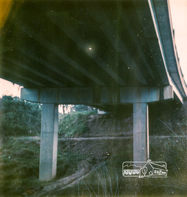
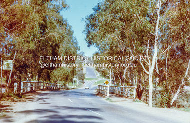 Eltham District Historical Society Inc
Photograph, Wattletree Road Bridge, Eltham, c. August 1977, 1977
Traffic island at intersection is lined with white-painted bluestone edging which originally was part of the Eltham lock-up situated at 728 Main Road. The bluestone has since been re-used (from late 1980s) at the rear of 728 Main Road to form the garden bed in car park. Colour photographeltham, infrastructure, main road, shire of eltham infrastructure, wattletree road bridge, bridge -
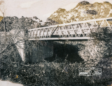
 Eltham District Historical Society Inc
Photograph, Lower Plenty Bridge
Faded colour photographManufacturer Markings: Polarcolor #6.infrastructure, bridge, shire of eltham infrastructure, lower plenty, lower plenty bridge, polaroid -
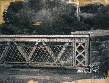
 Eltham District Historical Society Inc
Photograph, Old Lower Plenty Bridge, c.1966, 1966c
Black and white photographManufacturer's marks: Polaroid, Batch #J62K181 (Sep. 1966).infrastructure, bridge, shire of eltham infrastructure, lower plenty, lower plenty bridge, polaroid -
 Eltham District Historical Society Inc
Photograph, Old Lower Plenty Bridge, c.1966, 1966c
Black and white photographManufacturer's marks: Polaroid, Batch #J62K181 (Sep. 1966).infrastructure, bridge, shire of eltham infrastructure, lower plenty, lower plenty bridge, polaroid -
 Eltham District Historical Society Inc
Photograph, Old Lower Plenty Bridge, c.1966, 1966c
Black and white photographManufacturer's marks: Polaroid, Batch #J62K181 (Sep. 1966).infrastructure, bridge, shire of eltham infrastructure, lower plenty, lower plenty bridge, polaroid -
 Eltham District Historical Society Inc
Photograph, Old Lower Plenty Bridge, c.1966, 1966c
Black and white photographManufacturer's marks: Polaroid, Batch #J62K181 (Sep. 1966).infrastructure, bridge, shire of eltham infrastructure, lower plenty, lower plenty bridge, polaroid -
 Eltham District Historical Society Inc
Photograph, Old Lower Plenty Bridge, c.1966, 1966c
Black and white photographManufacturer's marks: Polaroid, Batch #J62K181 (Sep. 1966).infrastructure, bridge, shire of eltham infrastructure, lower plenty, lower plenty bridge, polaroid -
 Eltham District Historical Society Inc
Photograph, New road bridge at Lower Plenty towards Rosanna
Colour photographManufacturer's marks: Polarcolor 4, Batch #E65K753A.infrastructure, bridge, shire of eltham infrastructure, lower plenty, lower plenty bridge, polaroid -
 Eltham District Historical Society Inc
Photograph, New road bridge at Lower Plenty
Colour photographManufacturer's marks: Polarcolor 5, Batch #E65K753A.infrastructure, bridge, shire of eltham infrastructure, lower plenty, lower plenty bridge, polaroid