Showing 14542 items matching "bridge-playing"
-
 Eltham District Historical Society Inc
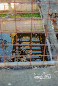
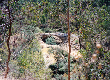
Negative - Photograph, Old Lower Plenty Bridge, 18 April 1998
Plenty River reflections through the old iron Lower Plenty Bridge; Autumn Excursion to Lower Plenty area. The blocked-off iron bridge at Lower Plenty - now re-opened and used as a footway/bike path section joining the Yarra River path.Roll of 35mm colour negative film, 2 strips and associated colour printKodak Gold 200-6activities, lower plenty bridge, autumn excursion, eltham district historical society, lower plenty -
 Melbourne Tram Museum
Document - Notice, Melbourne & Metropolitan Tramways Board (MMTB), "Reconstruction of Burnley Railway Bridge in Swan Street, Jun. 1969
Set of four notices regarding trackwork and reconstruction printed on foolscap paper. Signed by R. C. Drummond as Traffic Manager. .1 - Notice No. D1507 "Reconstruction of Burnley Railway Bridge in Swan Street - Sunday 13th April 1969" giving details of tram and bus rearrangements, procedure at the bridge for buses. .2 - Notice No. D1508 - regarding Burnley St rail bridge and the single line working that applied during the bridge reconstruction period - dated 10/4/1969. .3 - Notice No. D1546 about reconstruction of tram tracks in Collins St between Swanston and Elizabeth on Sunday 22 June 1969. Two pages, has been stapled in the top left hand corner. Gives bus and tram rearrangements. Dated 18/6/1969. .4 - Notice No. D1550 about reconstruction of tram tracks in Collins St near King St for 29 June 1969.. Two pages, has been stapled in the top left hand corner. Gives bus and tram rearrangements. Dated 24/6/1969.trams, tramways, mmtb, trackwork, burnley, swan st, signals, collins st -
 Eltham District Historical Society Inc
Negative - Photograph, Mr Belot smokes his pipe whilst resting at Cottle's Bridge, c.1990 (c.1890)
Copy of original photograph. The area, previously known as Back Creek, was named after Thomas Cottle, who settled in the district in the 1870s, and the original bridge over the Diamond Creek on the road to Strathewen. The original bridge (seen in the photo) was replaced with a new timber bridge at a cost of £1,500, the tender being awarded to a contractor named Birch who commenced work in June 1927. The gentleman in the photo who is resting whilst having a smoke of his pipe is a member of the Belot family.Roll of 35mm Black and White negative film, 3 strips, (1 of 14 frames)Film - Agfa Ortho 25belot, bridge, cottles bridge, cottles bridge-strathewan road, diamond creek (creek), heidelberg-kinglake road -
 Eltham District Historical Society Inc
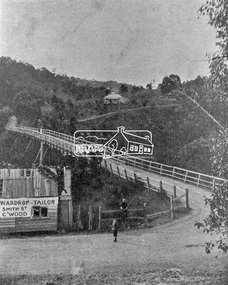
Photograph, Warrandyte Bridge on River Yarra
Bridge across the Yarra River which links North Warrandyte and Warrandyte. A house sits prominantly on a hill in the distance. A wooden building on the side of the road before the bridge has advertising for Wardrop Tailor, Smith Street, Collingwood. It is suggested that the photo has had this fake information added at a later date. Wardrop Tailor did operate from about 1915 to 1921. Alternataive title: Warrandyte Bridge - River Yarra. "Wardrop-Tailor, Smith St. C'wood" sign - faked?This photo forms part of a collection of photographs gathered by the Shire of Eltham for their centenary project book,"Pioneers and Painters: 100 years of the Shire of Eltham" by Alan Marshall (1971). The collection of over 500 images is held in partnership between Eltham District Historical Society and Yarra Plenty Regional Library (Eltham Library) and is now formally known as 'The Shire of Eltham Pioneers Photograph Collection.' It is significant in being the first community sourced collection representing the places and people of the Shire's first one hundred years.Digital imagesepp, shire of eltham pioneers photograph collection, warrandyte, bridge, north warrandyte, yarra river, wardrop tailor, collingwood -
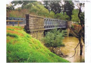 Greensborough Historical Society
Photograph - Photograph (Copy), Anne Paul, Old bridge, Lower Plenty 2003, 2003_12
Two views of the old bridge over the Plenty River in Lower Plenty.2 colour photographs printed on paper, handwritten captionslower plenty, plenty river, floods, edward willis drive lower plenty -
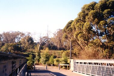 Greensborough Historical Society
Photograph - Photograph Collection, Anne Paul, Lower Plenty Bridge and surrounds, 2002c
Six photographs of the area surrounding the Old Plenty Bridge in Lower Plenty6 colour photographs lower plenty, plenty river, old plenty bridge -
 Greensborough Historical Society
Slide - Photograph, John Ramsdale, Bridge Inn Hotel and Mechanics Institute from rear: Slide 102, 1990s
Photograph shows Bridge Inn Hotel and Mechanics Institute from rear.Part of the John Ramsdale collection of slides and audio visual material.Colour photograph scanned from slide.No maker's marks. No caption on slide.bridge inn hotel mernda, mernda mechanics institute, mernda -
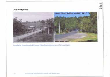 Greensborough Historical Society
Article and Photograph, Lower Plenty Bridge, 2016_
2 Photographs of the area around the Lower Plenty Bridge, 1906 and 2014.This photograph and text was copied from a Facebook site. Members are people who lived in the Greensborough area and share their reminiscences of the area with others. The site is administered by a GHS member but is not officially affiliated with the Society. Any information is the opinion of the contributor. Article and photograph sourced from social media.lower plenty -
 Greensborough Historical Society
Photograph - Digital image, Jan Lewis, Flintoff Street swing bridge with Greensborough Railway Station in background circa 1958, 1958c
Flintoff Street swing bridge and Greensborough station in background circa 1958Digital copy of black and white photographgreensborough station, flintoff street -
 Greensborough Historical Society
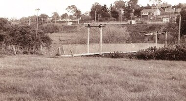
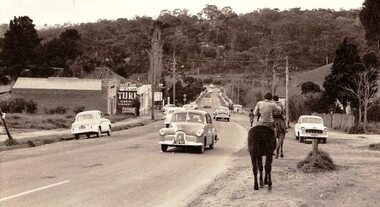
Photograph - Digital image, Jan Lewis, Horse Riding down Main Street Greensborough Station looking toward bridge circa 1958, 1958c
Main Street Greensborough Station looking toward bridge circa 1958.Digital copy of black and white photographmain street greensborough -
 Greensborough Historical Society
Photograph - Digital image, Marilyn Smith, Railway Road Rail Bridge over Plenty River Briar Hill, 17/09/2014
Rail bridge over Railway Road Greensborough, near Para Road.Digital copy of colour photographrailway road greensborough, para road greensborough -
 Eltham District Historical Society Inc
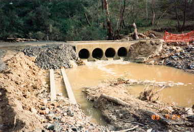
Photograph, Bridge construction over the Diamond Creek, Charlber Lane, St Andrews, 24 July 1989, 24 Jul 1989
The first BEBO Arch pre-cast concrete bridge construction in VictoriaNine colour photographic printsbebo arch, bridge construction, charlber lane, diamond creek, st andrews -
 Eltham District Historical Society Inc
Photograph, Charlber Lane Bridge, St Andrews
A BEBO Arch pre-cast concrete construction bridge, the first in VictoriaA BEBO Arch pre-cast concrete construction bridge, the first in VictoriaThree colour photographic printsbebo arch, bridge construction, charlber lane, diamond creek, st andrews -
 Eltham District Historical Society Inc
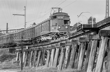
Photograph, George Coop, Tait Electric Train (Red Rattler) crossing the Railway Trestle Bridge at Eltham, c.1981, 1981
Heading to Princes Bridge in Melbourne Eltham Shire Council Offices in backgroundDigital TIFF file Scan of 35mm Ilford FP4 black and white transparencyeltham shire office, eltham trestle bridge, red rattler, tait train -
 Stawell Historical Society Inc
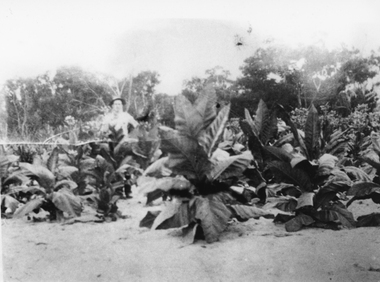
Photograph, Mr Charles Pickering with his Tobacco Crop at Dadswells Bridge c1930
Tobacco Crop Grown by Charles Pickering at Dadswells Bridge c 1930.Black and white photograph of a scene depicting Tobacco plants. A person is standing behind the crop.stawell -
 Stawell Historical Society Inc
Photograph, Delley's Bridge in Hall’s Gap showing Fyans Creek riverbed 1917
Delley's Bridge Hall’s Gap 1917 showing Fyans Creek riverbedstawell -
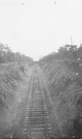 Stawell Historical Society Inc
Photograph, Railway Line from the Oddfellows Bridge c1930's
Sepia Photograph of rail line from Oddfellows Bridge 1930'sstawell railways transport -
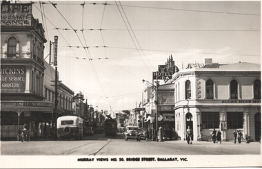 Ballarat Tramway Museum
Postcard, Murray Views, "Murray Views No. 50 Bridge Street Ballarat Vic", 1948
Photo shows the view looking east along Bridge St from Grenville St. Bogie tram 35 is in the shadows. A bus is entering Bridge St, In the view are Dickins Self service grocery, Morseheads store, CTA Hotel, and the Bucks Head Hotel. On the rear, Wal Jack to Ken Magor of Newcastle has written "No. 35 bogie to Victoria St, 1948. Bridge St from Sturt and Grenville Sts. Note two green lights on the span pole under neon sign which guards the Bridge St (bottom light) and Victoria St single track. Mt Pleasant light is on opposite side pole. No. 35 is standing at the old city terminus up to 1937."Yields information about Bridge St Ballarat and its various buildings.Postcard black and white, divided back, with a handwritten note on rear.See image 2 for details of the handwritten note by Wal Jack on the rear. tramways, trams, bridge st, tram 35, buses, dickins, bucks head hotel -
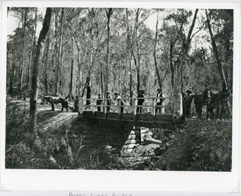 Lakes Entrance Historical Society
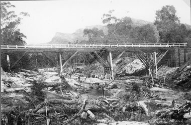
Photograph - Bridges, 1896
Original photo 12.5 x 17 cm on grey card 20 x 24.5 cmBlack and white photograph showing Boggy Creek Bridge,seven men on bridge, one horse at left end of bridge and two horses at right hand end of bridge. Bridge rests on log supports under. No water in creek. Thick bush around area. East Gippsland VictoriaBoggy Creek Bridge - Vic (Written on back)bridges, waterways, vegetation -
![Photograph - Digital image, Rand Street Bridge [Greensborough], 02/05/2013](/media/collectors/4f729f5697f83e03086015b8/items/572af0f12162f118342f250e/item-media/572af1252162f118342f2a1f/item-fit-380x285.jpg) Greensborough Historical Society
Greensborough Historical SocietyPhotograph - Digital image, Rand Street Bridge [Greensborough], 02/05/2013
These photographs of the Rand Street Bridge were taken in 2013 to show changes over 40 years, based on Ron Reynold’s sketches in the 1973 publication “Greensborough and Greenhills” published by Cypress Books. This is a pedestrian swing bridge over the Plenty River between Rand Street and Greensborough Station.Digital copy of colour photograph.greensborough and greenhills, rand street bridge, rand street greensborough, ron reynolds -
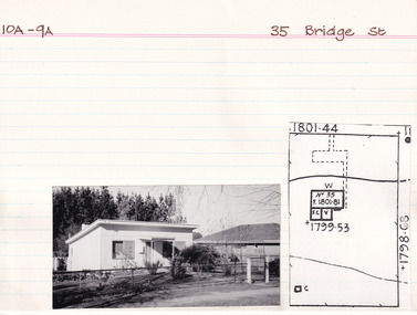 The Beechworth Burke Museum Research Collection
Card (Series) - Index Card, George Tibbits, 35 Bridge Street, Beechworth, 1976
George Tibbits, University of Melbourne. Faculty of Architecture, Building and Town & Regional PlanningIndex system that support the research for Beechworth : historical reconstruction / [by] George Tibbits ... [et al]Arranged by street names of BeechworthEach index card includes: street name and number of property, image of property, allotment and section number, property owners and dates of ownership, description of the property according to rate records, property floor plan with dimensions.beechworth, george tibbitsbeechworth, george tibbits -
 Ringwood and District Historical Society
Notes for book, Rogaughan, John, Material for History of Kilsyth, Croydon, Burnt Bridge and Ringwood (book never completed). By John Rogaughan (undated), not known
Collected for a history book of Kilsyth, Croydon, Burnt Bridge and Ringwood but never completed.27 pages of notes intended for a local history book typed with some connections. +Additional Keywords: Rogaughan, John -
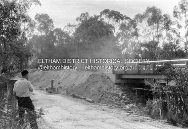
 Eltham District Historical Society Inc
Album - Photograph, J.A. McDonald, Henley Road Bridge over Watsons Creek, Aug. 1962
Henley Road Bridge over Watsons Creek Eltham Abutment August 1962Record of various Shire of Eltham infrastructure works undertaken during the period of 1952-1962 involving bridge and road reconstruction projects, sometimes with Eltham Shire Council Project Reference numbers quoted. It was during this period that a number of significant improvements were made to roads and new bridges constructed within the shire that remain in place as of present day (2022). In many situations, the photos provide a tangible visible record of infrastructure that existed throughout the early days of the Shire. The album was put together by or under the direction of the Shire Engineer, J.A. McDonald.H941 stamped on reverse (film processing #)infrastructure, shire of eltham, bridge construction, road construction, bushfires, 1962-08, bend of islands, henley road, henley road bridge, kangaroo ground, oxley bridge, watsons creek -
 Eltham District Historical Society Inc
Album - Photograph, J.A. McDonald, Henley Road Bridge over Watsons Creek, Sep. 1962
Henley Road Bridge over Watsons Creek Eltham Abutment September 1962Record of various Shire of Eltham infrastructure works undertaken during the period of 1952-1962 involving bridge and road reconstruction projects, sometimes with Eltham Shire Council Project Reference numbers quoted. It was during this period that a number of significant improvements were made to roads and new bridges constructed within the shire that remain in place as of present day (2022). In many situations, the photos provide a tangible visible record of infrastructure that existed throughout the early days of the Shire. The album was put together by or under the direction of the Shire Engineer, J.A. McDonald.H941 stamped on reverse (film processing #)infrastructure, shire of eltham, bridge construction, road construction, bushfires, bend of islands, henley road, henley road bridge, kangaroo ground, oxley bridge, watsons creek, 1962-09 -
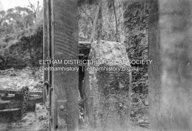 Eltham District Historical Society Inc
Album - Photograph, J.A. McDonald, Dixons Creek Bridge, c. 1962
Dixons Creel Bridge Broken head of pile View looking upstream ? eastRecord of various Shire of Eltham infrastructure works undertaken during the period of 1952-1962 involving bridge and road reconstruction projects, sometimes with Eltham Shire Council Project Reference numbers quoted. It was during this period that a number of significant improvements were made to roads and new bridges constructed within the shire that remain in place as of present day (2022). In many situations, the photos provide a tangible visible record of infrastructure that existed throughout the early days of the Shire. The album was put together by or under the direction of the Shire Engineer, J.A. McDonald.'66' written in pencil1962, bridge construction, dixons creek bridge, dixon's creek road, infrastructure, road construction, shire of eltham -
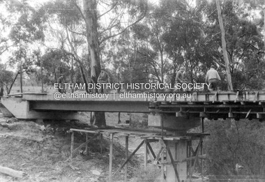
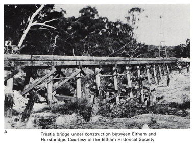 Eltham District Historical Society Inc
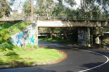
Work on paper (Sub-Item) - Photograph, Trestle bridge under construction between Eltham and Hurstbridge
Black and white photograph of the bridge under construction. The line opened at Hurstbridge in 1912.bridge, hurstbridge -
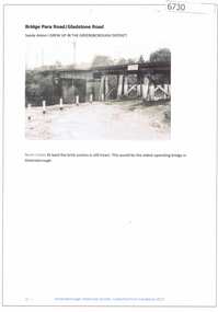 Greensborough Historical Society
Article and Photograph, Bridge at Para Road and Gladstone Road, 2018_
Information and photograph about the railway bridge at Para Road and Gladstone Road Greensborough.This photograph and text was copied from a Facebook site. Members are people who lived in the Greensborough area and share their reminiscences of the area with others. The site is administered by a GHS member but is not officially affiliated with the Society. Any information is the opinion of the contributor. Article and photograph sourced from social media.railway bridge greensborough, gladstone road briar hill, para road greensborough -
 Greensborough Historical Society
Photograph - Digital image, Jan Lewis, From Sondemeyer's looking towards swing bridge and Pope's farm, circa 1958, 1958c
From Sondemeyer's looking towards swing bridge and Pope's farm, circa 1958Digital copy of black and white photographsondemeyers hill, popes farm -
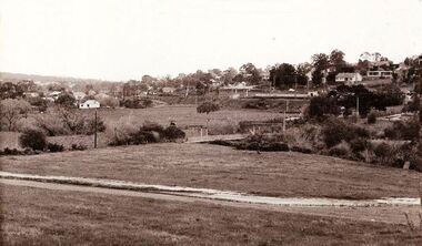
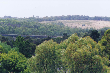 Greensborough Historical Society
Photograph - Digital image, Frank Solomon, View over Greensborough to Plenty River Drive bridge, 2010c
View over trees to the Greensborough By-pass bridge over Plenty River Drive.Digital copy of colour photographplenty river drive, greensborough bypass -
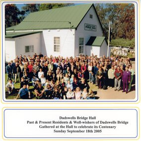 Stawell Historical Society Inc
Photograph, Spielvogel Photographic, Dadswells Bridge Hall
Colour photo of Dadswells Bridge building and gathering of people for centenary of Hall. 2005Colour photo in Folder