Showing 3238 items
matching george road
-
 Eltham District Historical Society Inc
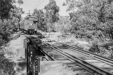
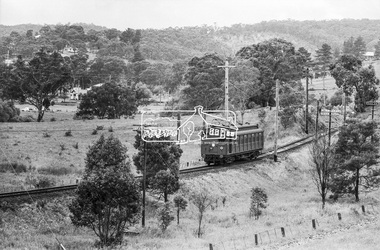
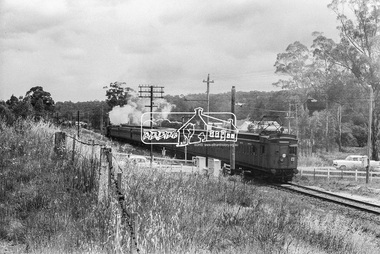
Photograph, George Coop, Single Motor Carriage (Red Rattler) Tait train heading for Eltham crossing over the Diamond Creek just north of Allendale Road, c.1981, 1981
... melbourne Allendale Road, Derailment guard rail, Diamond Creek ...Digital TIFF file Scan of 35mm Ilford FP4 black and white transparencyallendale road, derailment guard rail, diamond creek, railway bridge, single motor carriage, tait train -
 Eltham District Historical Society Inc
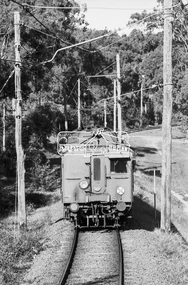
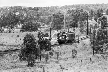
Photograph, George Coop, Single Motor Carriage 473M (Red Rattler) Tait train heading to Hurstbridge just before crossing over the Diamond Creek north of Allendale Road, 17 July 1983, 1983
Digital TIFF file Scan of 35mm Ilford FP4 black and white transparencyallendale road, diamond creek, hurstbridge line, red rattler, red rattler single carriage, single motor carriage, tait train -
 Eltham District Historical Society Inc
Photograph, Tait (Red Rattler) train bound for Mordialloc at McKinnon Road level crossing, Mckinnon Railway Station, Frankston line, c.1970, 1970
The level crossing is the old McKinnon Rd. level crossing right at Mckinnon Railway Station on the Melbourne-Franston line. It no longer exists as the level crossing was amongst the first to be removed in the State Govt. grade separation programme c 2015. The line now runs under Mckinnon Rd in a cutting that holds the new station as well. The folding metal lattice gates were the only ones of their kind in Victoria and fairly rare anywhere else in Australia as well. Digital TIFF file Scan of 9 x 13 cm black and white printfrankston line, mordialloc, red rattler, tait train, mckinnon road, level crossing, mckinnon railway station -
 Eltham District Historical Society Inc
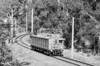
Photograph, Single Motor Carriage (Red Rattler) Tait train on its way to Hurstbridge, near Wattletree Road, Eltham North, c.1970, 1970
Possibly 471M. View appears to be from near Coolabah Drive looking northwest across parts of Edendale Farm and to the oval near the present day Adventure Playground and Wattletree Road.Digital TIFF file Scan of 35mm Ilford HP4 black and white transparency471m, edendale farm, eltham north, eltham north adventure playground, george coop collection, red rattler single carriage, single motor carriage, tait train, wattletree road -
 Eltham District Historical Society Inc
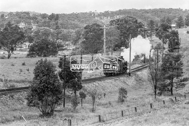
Photograph, Steam locomotive D-639 Vintage train excursion, Hurstbridge to Eltham, near Wattletree Road, Eltham North, c.1970, 1970
View appears to be from near Coolabah Drive looking northwest across parts of Edendale Farm and to the oval near the present day Adventure Playground and Wattletree Road. Possibly run in conjunction with the Eltham Community Festival or the Hurstbridge Wattle Festival; the steam train would conduct trips between Eltham and Hurstbridge Railway stations. As there is no turning table at Hurstbridge, the locomotive would simply shunt from one end of the carriages to the other to reverse direction, hence the locomotive is running in reverse as it approaches Eltham Station.Digital TIFF file Scan of 35mm Ilford HP4 black and white transparencyd-639, edendale farm, eltham festival, eltham north, eltham north adventure playground, george coop collection, hurstbridge wattle festival, steam engine, vintage train excursion, wattletree road -
 Eltham District Historical Society Inc
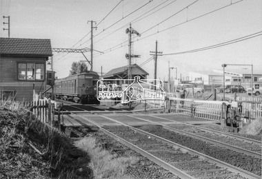
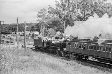
Photograph, Steam locomotive D-639 Vintage train excursion bound for Eltham at the Wattletree Road level crossing, Eltham, c.1970, 1970
Possibly run in conjunction with the Eltham Community Festival or the Hurstbridge Wattle Festival; the steam train would conduct trips between Eltham and Hurstbridge Railway stations. As there is no turning table at Hurstbridge, the locomotive would simply shunt from one end of the carriages to the other to reverse direction, hence the locomotive is running in reverse as it approaches Eltham Station. The first house in the background on Railway Parade, Number 97, remains as of 2019. The next house, Number 95 has been demolised since April 2018 and new construction in place.Digital TIFF file Scan of 35mm Ilford HP4 black and white transparencyd-639, eltham festival, george coop collection, hurstbridge wattle festival, level crossing, passenger carriage 19bc, railway parade, steam engine, vintage train excursion, wattletree road -
 Eltham District Historical Society Inc
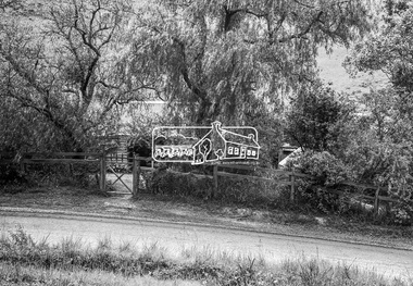
Photograph, Birch Cottage, Eltham-Yarra Glen Road, c.1970, 1970
... Cottage, Eltham-Yarra Glen Road, c.1970 Photograph George Coop ...GC advised that when they first arrived in Eltham in the late 1960s, he would enjoy driving out to Yarra Glen. The Eltham-Yarra Glen road was unmade at the time. He passed this residence on the north side of the road. It was totally remote. GC found the juxtaposition of this little cottage with its surburban wire gate out in the remoteness of the landscape intriguing. Since then the road has been reconstructed and diverted away from the cottage which is now owned by Parks Victoria.Digital TIFF file Scan of 35mm Ilford HP4 black and white transparencyIlford HP4birch cottage, christmas hills, early settlers, edwin samuel birch, eltham-yarra glen road, honor mary birch, honor mary williams, john hill, watsons creek -
 Eltham District Historical Society Inc
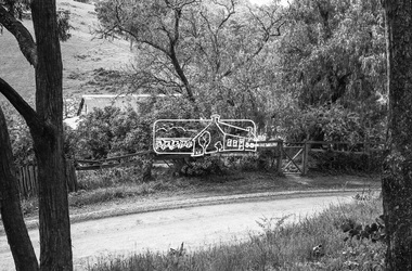
Photograph, Birch Cottage, Eltham-Yarra Glen Road, c.1970, 1970
... Cottage, Eltham-Yarra Glen Road, c.1970 Photograph George Coop ...GC advised that when they first arrived in Eltham in the late 1960s, he would enjoy driving out to Yarra Glen. The Eltham-Yarra Glen road was unmade at the time. He passed this residence on the north side of the road. It was totally remote. GC found the juxtaposition of this little cottage with its surburban wire gate out in the remoteness of the landscape intriguing. Since then the road has been reconstructed and diverted away from the cottage which is now owned by Parks Victoria.Digital TIFF file Scan of 35mm Ilford HP4 black and white transparencyIlford HP4birch cottage, christmas hills, early settlers, edwin samuel birch, eltham-yarra glen road, honor mary birch, honor mary williams, john hill, watsons creek -
 Eltham District Historical Society Inc
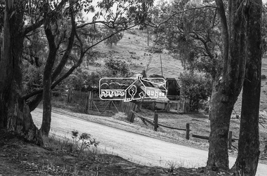
Photograph, Birch Cottage, Eltham-Yarra Glen Road, c.1970, 1970
... Cottage, Eltham-Yarra Glen Road, c.1970 Photograph George Coop ...GC advised that when they first arrived in Eltham in the late 1960s, he would enjoy driving out to Yarra Glen. The Eltham-Yarra Glen road was unmade at the time. He passed this residence on the north side of the road. It was totally remote. GC found the juxtaposition of this little cottage with its surburban wire gate out in the remoteness of the landscape intriguing. Since then the road has been reconstructed and diverted away from the cottage which is now owned by Parks Victoria.Digital TIFF file Scan of 35mm Ilford HP4 black and white transparencyIlford HP4birch cottage, christmas hills, early settlers, edwin samuel birch, eltham-yarra glen road, honor mary birch, honor mary williams, john hill, watsons creek -
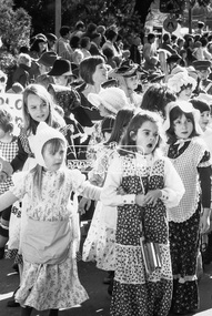
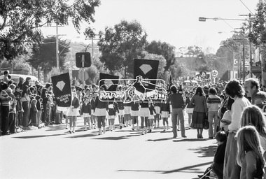 Eltham District Historical Society Inc
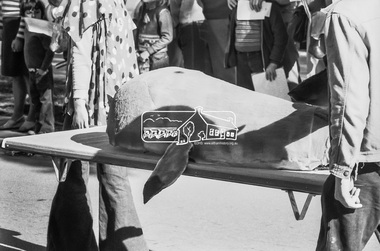
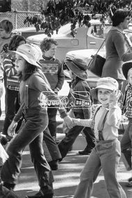
Photograph, Valley Jewelers Marching Band, Eltham Community Festival Grand Parade, Main Road near Arthur Street, Eltham, 6 August 1977, 1977
... 1977, Eltham Festival, George Coop Collection, Main Road... Festival Program 1977, Eltham Festival, George Coop Collection ...Saturday 6th, August "Grand Parade, 10.30 a.m., Main Rd., Eltham. Dozens of local groups will be participating. Entries include ponies, Scouts, elderly citizens, bands, athletic clubs, life-be-in-it display, schools and many many more." - 1977 Festival ProgramDigital TIFF file Scan of 35mm Kodak Tri-X black and white transparencyKodak Tri-X1977, eltham festival, george coop collection, main road, parade, valley jewelers marching band -
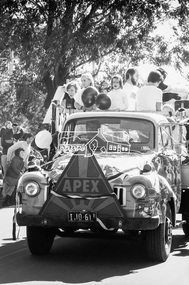 Eltham District Historical Society Inc
Photograph, Apex, Eltham Community Festival Grand Parade, Main Road near Arthur Street, Eltham, 6 August 1977, 1977
... 1977, eltham festival, george coop collection, main road... Festival Program 1977, eltham festival, george coop collection ...Saturday 6th, August "Grand Parade, 10.30 a.m., Main Rd., Eltham. Dozens of local groups will be participating. Entries include ponies, Scouts, elderly citizens, bands, athletic clubs, life-be-in-it display, schools and many many more." - 1977 Festival ProgramDigital TIFF file Scan of 35mm Kodak Tri-X black and white transparencyKodak Tri-X1977, eltham festival, george coop collection, main road, parade, apex club -
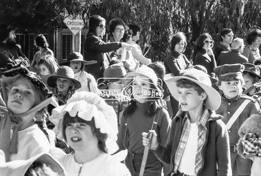
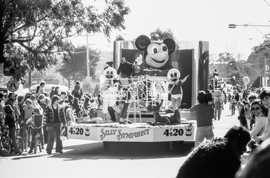 Eltham District Historical Society Inc
Photograph, Eltham Community Festival Grand Parade, Main Road near Arthur Street, Eltham, 6 August 1977, 1977
... 1977, eltham festival, george coop collection, main road... Festival Program 1977, eltham festival, george coop collection ...Saturday 6th, August "Grand Parade, 10.30 a.m., Main Rd., Eltham. Dozens of local groups will be participating. Entries include ponies, Scouts, elderly citizens, bands, athletic clubs, life-be-in-it display, schools and many many more." - 1977 Festival ProgramDigital TIFF file Scan of 35mm Kodak Tri-X black and white transparencyKodak Tri-X1977, eltham festival, george coop collection, main road, parade -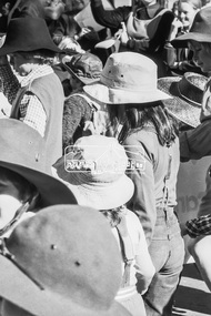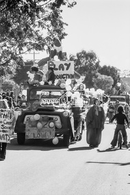
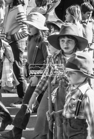
 Eltham District Historical Society Inc
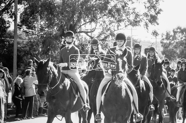
Photograph, Horse and Pony Club, Eltham Community Festival Grand Parade, Main Road near Arthur Street, Eltham, 6 August 1977, 1977
... 1977, eltham festival, george coop collection, main road... Festival Program 1977, eltham festival, george coop collection ...Saturday 6th, August "Grand Parade, 10.30 a.m., Main Rd., Eltham. Dozens of local groups will be participating. Entries include ponies, Scouts, elderly citizens, bands, athletic clubs, life-be-in-it display, schools and many many more." - 1977 Festival ProgramDigital TIFF file Scan of 35mm Kodak Tri-X black and white transparencyKodak Tri-X1977, eltham festival, george coop collection, main road, parade, horse and pony club, -
 Eltham District Historical Society Inc
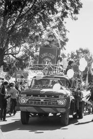
Photograph, Lions Club Eltham, Eltham Community Festival Grand Parade, Main Road near Arthur Street, Eltham, 6 August 1977, 1977
... 1977, eltham festival, george coop collection, main road... Festival Program 1977, eltham festival, george coop collection ...Saturday 6th, August "Grand Parade, 10.30 a.m., Main Rd., Eltham. Dozens of local groups will be participating. Entries include ponies, Scouts, elderly citizens, bands, athletic clubs, life-be-in-it display, schools and many many more." - 1977 Festival ProgramDigital TIFF file Scan of 35mm Kodak Tri-X black and white transparencyKodak Tri-X1977, eltham festival, george coop collection, main road, parade, lions club eltham -
 Eltham District Historical Society Inc
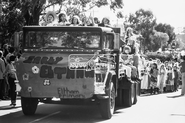
Photograph, Eltham Primary School, Eltham Community Festival Grand Parade, Main Road near Arthur Street, Eltham, 6 August 1977, 1977
... 1977, eltham festival, george coop collection, main road... Festival Program 1977, eltham festival, george coop collection ...Saturday 6th, August "Grand Parade, 10.30 a.m., Main Rd., Eltham. Dozens of local groups will be participating. Entries include ponies, Scouts, elderly citizens, bands, athletic clubs, life-be-in-it display, schools and many many more." - 1977 Festival ProgramDigital TIFF file Scan of 35mm Kodak Tri-X black and white transparencyKodak Tri-X1977, eltham festival, george coop collection, main road, parade, eltham primary school -
 Eltham District Historical Society Inc
Photograph, Eltham Community Festival Grand Parade, Main Road near Arthur Street, Eltham, 6 August 1977, 1977
... 1977, eltham festival, george coop collection, main road... Festival Program 1977, eltham festival, george coop collection ...Saturday 6th, August "Grand Parade, 10.30 a.m., Main Rd., Eltham. Dozens of local groups will be participating. Entries include ponies, Scouts, elderly citizens, bands, athletic clubs, life-be-in-it display, schools and many many more." - 1977 Festival ProgramDigital TIFF file Scan of 35mm Kodak Tri-X black and white transparencyKodak Tri-X1977, eltham festival, george coop collection, main road, parade -
 Running Rabbits Military Museum operated by the Upwey Belgrave RSL Sub Branch
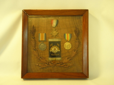
Memorial, Commonwealh of Australia et al, Family Memorial case for deceased veteran son, post World War One
The War Medal, 1914-1918 Medal and the Victory Medal, Mothers Badge (for being the mother of a deceased soldier) with a plaque from King George honouring the Service of L/Cpl Chester George Mather on the other. L/Cpl Mather enlisted on 8th of June 1915 and embarked for France on HMAT Anchises on the 26th Augest 1915. He was killed at Polygon Wood, Zillebrook near Ypres in Belgium on 4th October 1917 aged 25.Double sided wooden and glass display caseOn one side are the Sons Medals (War Medal, 1914-1918 Medal and the Victory Medal), Mothers Badge (for being the mother of a deceased soldier) with a plaque from King Geaorge honouring the Service of "L/Cpl Chester George Mather of the 22nd Battalion AIF" on the otherworld war one, medal, military, ypres, badge, plaque, polygon wood -
 Running Rabbits Military Museum operated by the Upwey Belgrave RSL Sub Branch
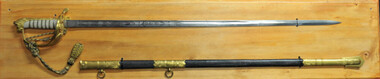
Naval Ceremonial Sword, Wilkinson Sword, c 1960
Used by Leonard George Pollard. He served in H.M.A.S. ANZAC in Vietnam and retired as LCDR Engineer Ceremonial Naval Officers Sword Fine etching on both sides of the bladeh.m.a.s. anzac, hmas sydney & the vietnam logistics support veterans association -
 Running Rabbits Military Museum operated by the Upwey Belgrave RSL Sub Branch
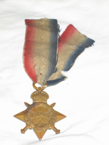
Medals, Medals of L/Cpl George William Steele
Wounded7/5/1915 Gallipoli Died of Wounds at sea in transit to hospital The 1914 Star This bronze medal award was authorized by King George V in April 1917 for those who had served in France or Belgium between 5th August 1914 to midnight on 22nd November 1914 inclusive. The reverse is plain with the recipient's service number, rank, name and unit impressed on it. It should be remembered that recipients of this medal were responsible for assisting the French to hold back the German army while new recruits could be trained and equipped. Collectively, they fully deserve a great deal of honour for their part in the first sixteen weeks of the Great War. There were approximately 378,000 1914 Stars issued. The British War Medal, 1914-18 The silver or bronze medal was awarded to officers and men of the British and Imperial Forces who either entered a theatre of war or entered service overseas between 5th August 1914 and 11th November 1918 inclusive Approximately 6.5 million British War Medals were issued. Approximately 6.4 million of these were the silver versions of this medal. The recipient's service number, rank, name and unit was impressed on the rim. SN 1053 14Btn AIF -
 Running Rabbits Military Museum operated by the Upwey Belgrave RSL Sub Branch
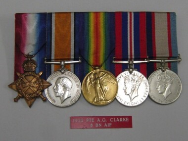
Medals, Medals of PTE Arthur Ernest Clarke
WW1 Served in Gallipoli & France WW2 Militia The 1914 Star This bronze medal award was authorized by King George V in April 1917 for those who had served in France or Belgium between 5th August 1914 to midnight on 22nd November 1914 inclusive. The reverse is plain with the recipient's service number, rank, name and unit impressed on it. It should be remembered that recipients of this medal were responsible for assisting the French to hold back the German army while new recruits could be trained and equipped. Collectively, they fully deserve a great deal of honour for their part in the first sixteen weeks of the Great War. There were approximately 378,000 1914 Stars issued. The British War Medal, 1914-18 The silver or bronze medal was awarded to officers and men of the British and Imperial Forces who either entered a theatre of war or entered service overseas between 5th August 1914 and 11th November 1918 inclusive Approximately 6.5 million British War Medals were issued. Approximately 6.4 million of these were the silver versions of this medal. The recipient's service number, rank, name and unit was impressed on the rim. The Allied Victory Medal Approximately 5.7 million victory medals were issued. The recipient's service number, rank, name and unit was impressed on the rim. The 1939-45 Star Awarded for service as follows: • Army - awarded for six months service in an operational command during the period 3 September 1939 to 2 September 1945. The War Medal 1939-45 Awarded to members who served full-time in operational or non-operational service between 3 September 1939 and 2 September 1945. Clarke SN 1703 8 Btn AIF -
 Running Rabbits Military Museum operated by the Upwey Belgrave RSL Sub Branch
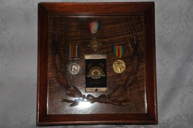
Framed Medals
Framed 1914/15 Star, British War Medal, Victory Medal, Embroidered "for Australia" cloth & Metal Scroll, Death Brooch. L/Cpl Chester George Mather 22 Btn KIAmedals, ww1, army