Showing 3733 items matching "landscapes"
-
 Bendigo Historical Society Inc.
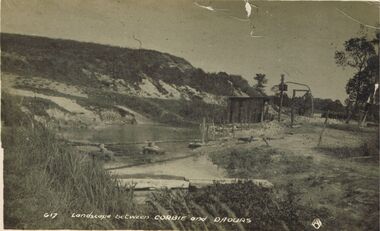
Postcard - ACC LOCK COLLECTION : LANDSCAPE BETWEEN CORBIE AND DAOURS, POSTCARD, 1914-1918
Postcard, WW1, B&W image of a landscape between Corbie and Daours. Hillside with a dam in foreground with what is probably a pump shed. Copy G17postcard, ww1, corbie, daours, france, dam -
 Bendigo Historical Society Inc.
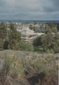
Photograph - FORTUNA COLLECTION: FORTUNA BENDIGO 1970, 1970
Colour Photo of Fortuna Bendigo in 1970, landscape type shot with Fortuna in the middle of photo, markings on rear of photo read 'Fortuna Bendigo 1970'buildings, house, fortuna, fortuna, bendigo, 1970 -
 Benalla Art Gallery
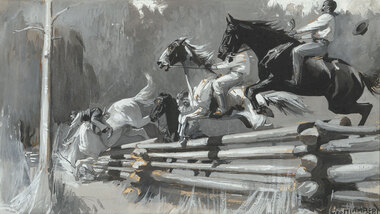
Painting, George W. LAMBERT, Shearer's Sunday, 1899, 1899
Born: St Petersburg, Russia 1873; Arrived: Sydney, New South Wales, Australia 1887; Lived and worked: England, France, Wales, Egypt, Palestine 1900-1921; Died: Cobbity, New South Wales, Australia 1930NationalismGift of Mrs E.E. Ledger, 1982Rural landscape with four horses and riders jumping a fence. Image is in black and white colour. Dark stained, gold and grey brushed timber frame.Recto: Signed "GEO.W.LAMBERT" in black watercolour in l.r.c of composition; Not dated; Not titledpainting, rural, horses, animals, figures, fence, jump, tree -
 Benalla Art Gallery
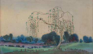
Watercolour, William Blamire YOUNG, Japanese willow, Not dated
Born: Londesborough, Yorkshire, England 1862; Arrived: Sydney, New South Wales Australia 1885; Lived and worked: England 1893-1896; Died: Montrose, Victoria, Australia 1935VictorianLedger Gift, 1985Rural landscape with large weeping tree, fence, rolling hills, line of trees and sky. Grey rubbed from gold gesso timber frameRecto: Signed "BLAMIRE YOUNG-" in white watercolour in l.l.c of composition; Not dated; Not titledwatercolour, landscape, trees, fence -
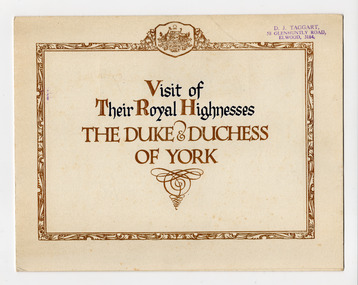 St Kilda Historical Society
Ephemera - Invitation, Visit of Their Royal Highnesses the Duke & Duchess of York, 1927
Invitation from the Commonwealth Government to ceremonies connected with the opening of Parliament House in Canberra on 9 May 1927. Visiting Australia for this purpose were the Duke and Duchess of York (later King George VI and Elizabeth the Queen Mother).Card, folded in half, printed in blue and gold. Affixed inside is a reproduction of a landscape painting Canberra 1927 by Harold B Herbert (1892-1945).The invitation was issued to 'W Nicoll Esq'royal visits, duke and duchess of york, opening of parliament house canberra -
 Tatura Irrigation & Wartime Camps Museum
Photograph, Goulburn Waranga Main Channel Construction, 1957
Taken by photographer for State Rivers and Water Supply Commission.Large black and white photograph dry mounted on to cream board. Landscape scene depicting newly excavated ground with solitary man within scene.Below photograph: "GOULBURN WARANGA MAIN CHANNEL CONSTRUCTION / CHANNEL EXCAVATION AND BEACHING / LOOKING DOWNSTREAM" victoria state rivers and water supply commission, goulburn waranga main channel, goulburn, waranga -
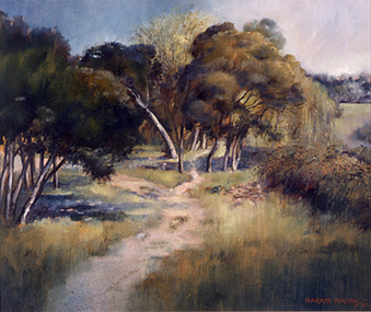 Nillumbik Shire Council
Harris (Maureen) SMITH (b.AUS - active 80's), Evening Eltham, 1984
The painting was purchased from the Eltham Outdoor Art Show. Smith endeavours to capture mood, atmosphere and light in this work by heightening and intensifying the imagery where possible. Smith is concerned with expressing a 'sense of place' inherent in the subject matter. Painting of a landscape at dusk with dirt walking track and trees somewhere in Eltham. Oil on composition board. Moulded frame. Painted in the 'Western Realist Tradition'. Signed 'HARRIS SMITH/84' Hand painted in capitals in red paint; bottom right. eltham, painting, landscape, smith, evening -
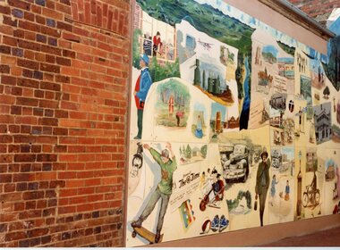 Stawell Historical Society Inc
Photograph, Pioneer Walk -- 3 Photos
Three colour photos of Pioneer Walk located between Main & Church Streets Stawell, photos taken in November 1992. One photo is of Big Hill and the other two of people and scenes and mining in Stawell.Three colour photos of collages decorating a walkway. The scenes are of people, building and landscapes. Copies also found in Album 4, p.49-50.151 Stawell History Mural, eft panel. Nov. 1992 151 Stawell Mural in Pioneer Walk Nov/92 151.1 Stawell Mural, center section Big Hill view. Nov.1992stawell -
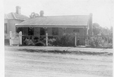 Stawell Historical Society Inc
Photograph - Family Home, "Burnside" Stawell West
Huttley - MartinB/W: Landscape: Steel roof, 2 chimneys, weatherboard. Fence wood uprights, wire - wooden pailing gate. Garden front to back"Burnside" Stawell West Family Homehuttley, martin -
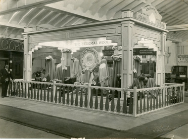 National Wool Museum
Photograph, Federal Woollen Mills Ltd, The Federal Woollen Mills Display, July 1928
Image of The Federal Woollen Mills mills display from the 'Made in Australia' Exhibition held at the Geelong in July 1928. The exhibition was organised by the manufacturers sectional committee of the Geelong Chamber of Commerce and Manufactures. Over 50,000 people attended the exhibition, making the exhibitors and organisers delighted at the result.Black and white photograph of a Federal Woollen Mills display in a landscape format. The exhibit featured draping fabrics and a suited man in the left hand edge.Center of display - The Federal Woollen Mills Pty Ltd. Geelong. Famous Federalia Fabricswool, woollen mills, wool manufacture, federal woollen mills, 'made in australia' exhibition, geelong -
Whitehorse Historical Society Inc.
Document, Surrey Lodge, 2005
Landscape conservation analysis prepared by Lee Andrews & Associates Heritage Consulting.Landscape conservation analysis prepared by Lee Andrews & Associates Heritage Consulting, featuring 520-528 Mitcham Road and listing schedules to the Heritage Overlay.Landscape conservation analysis prepared by Lee Andrews & Associates Heritage Consulting.surrey lodge, mitcham road, mitcham, nos. 520-528, heritage buildings, city of whitehorse -
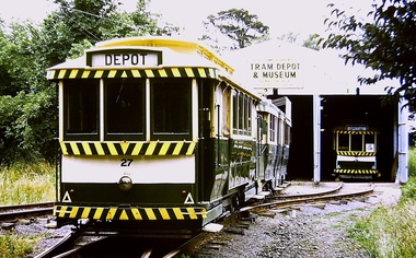 Ballarat Tramway Museum
Photograph - Digital image, Chris Phillips, c1975
Yields information about the BTPS depot c1975 and its surrounds.Digital image of No. 27, 38 and 14 on the BTPS Depot fan c1975. Shows the track layout prior to landscaping and the long grass on the south side.trams, tramways, btps, depot, tram 27, tram 38, tram 14 -
University of Melbourne, Burnley Campus Archives
Photograph - Black and white print, 924/8, 20 October 1947
"20/10/47. Eucalyptus camaldulensis standing in Richmond Park forms part of the landscape of Burnley gardens. Viewed from Oak Lawn." THK eucalyptus, richmond park, burnley gardens, oak lawn, e. m. gibson collection -
Lakes Entrance Historical Society
Book, Mountford C P, The Art of Albert Namatjirra, 1944
An account of t he Aboriginal artist Alber Namatjirra and his remarkable talent as a watercolour landscape painter. Illustrated with some reproductions of his art.aboriginals -
University of Melbourne, Burnley Campus Archives
Plan, 30 Lorne Pde Surrey Hills Preliminary Site Plan 1:100, c. 1980
Tracing paper copy, "Preliminary Site Plan," by "?N." and a rough sketch on paper. Scale 1:100. Possibly Landscape Design Project 1978.surrey hills, landscape design -
Lakes Entrance Historical Society
Book, LERHS members, Foreshore Development, 2002
A folder of clippings from local newspapers showing the development of the foreshore to enhance the landscape and provide recreation areas for the general public Lakes Entrance Victoriajetties, coast, environment -
 Greensborough Historical Society
Photograph - Digital image, Landscape, possibly Greensborough, 1930c
Photograph of unidentified landscape, possibly Greensborough. From the Yandell collection.Digital copy of colour photograph.greensborough -
 City of Ballarat Libraries
Photograph - Card Box Photographs, Eureka Memorial, Ballarat 1903
Panorama view of the Eureka Memorial. The garden has yet to be landscaped.eureka memorial, gardens, public -
University of Melbourne, Burnley Campus Archives
Work on paper (item) - Student Work, Jane McKenzie-Smith, Ironbark Designs Landscape Design, 2015
The sheets were submitted as part of a landscape design project, most likely for HORT90035, 'Landscape Construction and Graphics,' a subject at Burnley Horticultural College coordinated by Andrew Laidlaw. It seems there is a third sheet missing that would have been the site analysis component of this project. assignment, landscaping, burnley horticultural college, landscape construction and graphics -
 Marysville & District Historical Society
Photograph (Item) - Black and white photograph, Nicholas John Caire, c1880-1884
A copy of an early black and white photograph of Murchison Street in Marysville in Victoria taken by Nicholas John Caire.A copy of an early black and white photograph of Murchison Street in Marysville in Victoria taken by Nicholas John Caire. Murchison Street was named for Roderick Impey Murchison who was one of the most distinguished geologists of the 19th century. His liberality and social position plus the pride he took in his science were of immense value in furthering the cause of learning in Britain. Nicholas John Caire was born in 1837 in Guernsey. He arrived in Adelaide about 1860 along with his parents who encouraged his early interest in photography. He opened a studio in Adelaide in 1867 after traveling extensively throughout the Gippsland taking photographs. After marrying in 1870 he moved to Talbot in Victoria until 1876 when he opened a studio in the Royal Arcade in Melbourne. After 1885 Nicholas John Caire gave up his city work and made his home in South Yarra and devoted the rest of his life to outdoor photography, specializing in the bush, the gullies, and the mountains of south-eastern Victoria. LES HARSANT/ HEALESVILLE Entrance to Marysville/ from Nicholas Caire photo - c.1880-84 See Pitkethly, N.J. Caire, Landscape Photographer Pithkethly, Rosanna, Vic. 1988; plate 17murchison street, marysville, victoria, nicholas john caire, roderick impey murchison, geology, geologist -
 Latrobe Regional Gallery
Print, ORTON, Alison, Fossil Landscape 1999, 1999
Coloured LinocutSigned and dated 'A. ORTON 1999' in lower right corner under printed image. Titled 'Fossil Landscape' centred under print. Edition in lower left corner under printed image - illegible. -
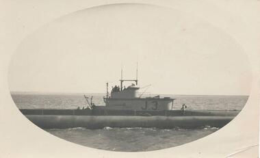 Phillip Island and District Historical Society Inc.
Photograph, Submarine in Westernport, c. 1940
Part of a collection from Jessie Smith of Phillip Island events and landscapes.Submarine J.3 at sea - close up in Westernport.local history, photographs, military history, navy, naval submarine, cowes jetty, phillip island, black & white photograph, wwii, jessie smith collection, stan mcfee -
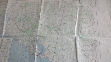 Peterborough History Group
Map - Government map, Government Printer, Port campbell, 1957
Aerial survey map showing roads, vegetation and other landscape features.Significant because it shows the detail of the region in 1957Original 1957 State Aerial Survey Map of Port Campbell region, including Peterboroughpeterborough, aerial survey map, maps, port campell -
Stawell Historical Society Inc
Map - Plan, Earle and Partners, Restoration of Pleasant Creek Courthouse Stawell West 1974, 24/10/1974
Drawing 1 Is not in Collection Drawing 5 Landscape Pal is 5092-13 A2 Sheets. Drawing 3 is Elevations. Drawing 2 is Gallery And Roof Plan. Drawing 4 Details24 Oct 74. And 25 Oct 74stawell historical -
University of Melbourne, Burnley Campus Archives
Work on paper (item) - Student Work, Alexandra White, Construction Elements, Uncertain, probably 2017-2018
Submitted as an assignment for HORT90035, 'Landscape Construction and Graphics,' coordinated by Andrew Laidlaw. assignment, landscaping, burnley horticultural college, landscape construction and graphics, hort90035 -
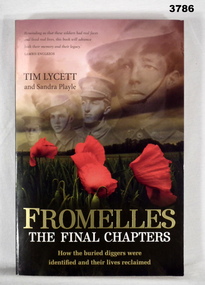 Bendigo Military Museum
Book - BOOK WW1, Tim Lycett, Fromelles - The Final Chapters, 2013
Fromelles - The Final Chapters - How the buried diggers were identified and their lives reclaimed.Soft cardboard cover. Gold / white / black print on front, spine & back. Illustrated front to back, photos of field of poppies in landscape with 4 soldier's portraits in soft sepia tones in the sky of the landscape. 262 pages, cut, plain, off white. Between pages 134 - 135 are an illustrated collection of photos in black / white / colour / sepia on glossy white paper.book, fromelles -
 Glenelg Shire Council Cultural Collection
Print, Unentitled, 1987
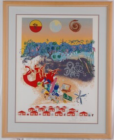
UnknownPrint of a landscape scene in upper half of print. In a blue and orange sky are three roundels with (l-r): an indigenous soldier (c. WWII) overprinted with red and yellow, a depiction of the view of Earth from space, and a curled snake in reds and browns. In the landscape scene are line-drawn figures, a montage of items of modern technology and a child-like drawing of houses and cars in garages.Front: 26/30 (lower left) "Unentitled" (lower centre) Rex Davies Vicki Gordon Bruce Robert Peagram Maria Gibbs P. Tsernjavski Barb Sharrock (lower left) (pencil) Back: (no inscriptions) -
 Orbost & District Historical Society
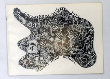
magazines, Croajingolong 1971, 1971
This is the twenty-fourth issue of the annual magazine of Orbost High School. The name Croajingolong derives from the Australian Aboriginal Krauatungalung words galung, meaning "belonging to" and kraua, meaning "east". 2219.1 belonged to Mary Gilbert, a former teacher at the school. 2219.2 belonged to Peter Traill.This magazine is a useful reference tool.Three copies of Croajingolong 1971. The magazine is in landscape format and has a white cover with a free form shape filled with mosaic type patterns in black and white. 2219.2 has Peter Trailll written in blue pen on the front cover.croajingolong orbost-high-school -
 Mission to Seafarers Victoria
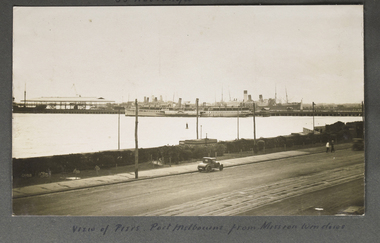
Photograph - Photograph, Sepia, View of Piers, Port Melbourne from Mission windows, Early 20th C
This image appears to have been taken from the second storey of the Mission to Seamen, on Beach Rd Esplanade, Port Melbourne circa 1912 - 1920. One of several images on loose album pages.An early image taken from the building established in Port Melbourne initially in the mid 19th C and operating up to the 1930s until replaced by a modern deco building in 1936. Shows examples of vintage cars.Small Landscape B and W image of ships moored alongside a pier in distance and small early car in foreground on unsealed road travelling left to right. Handwritten descriptive inscription is written underneath on an album page.port melbourne, mission to seamen building, port melbourne pier, fan album -
 Mission to Seafarers Victoria
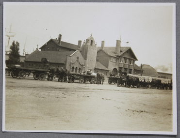
Photograph - Photograph, Black and white, Reverend John Reginald Weller, The luncheon hour, c. 1925
Landscape black and white photograph with a thin white border depicting the front of the Mission on Flinders Street and showing how busy it can get with horse cartsHandwritten in white ink on the left: The luncheon hourweller album, weathervane, norla dome, horse carriage, flinders street, luncheon