Showing 5786 items matching "location"
-
 Bendigo Historical Society Inc.
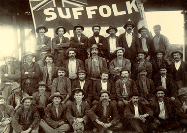
Photograph - Norman Penrose collection: Miners at the Suffolk mine
The Suffolk United Mine was adjacent to the New Moon mining lease.Black and white photograph glued to cardboard. Large group of miners in front of a Suffolk mine sign. There is no information about location of this mine. suffolk mine, miners -
 Clunes Museum
Booklet - PROGRAM, CLUNES BOOKTOWN 2022
.1 PROGRAMME BOOKLET FOR CLUNES BOOKTOWN 30/4-1/05/2022 .2 MAP AND LOCATIONS OF EVENTS BOOKTOWN 2022clunes booktown, booktown 2022 -
Lakes Entrance Historical Society
Book, Love Don, Shipwrecks around Port Phillip Heads, 2007
Well documented stories of the shipwrecks around Port Phillip Heads Victoria 1840-1900 with references photographs location Map and sketches.ships and shipping, history -
![Manuscript, As We Go to Press. [Recollections of the Bacchus Marsh Express Newspaper and Printing Company]](/media/collectors/5e461d8021ea67224c82f2a1/items/6822ccb5aa2a8060869222f7/item-media/6822cd36aa2a806086923fda/item-fit-380x285.jpg) Bacchus Marsh & District Historical Society
Bacchus Marsh & District Historical SocietyManuscript, As We Go to Press. [Recollections of the Bacchus Marsh Express Newspaper and Printing Company]
Allan Arnup was born in Bacchus Marsh in 1913. In 1929 he began work at the Bacchus Marsh Express newspaper as an apprentice printer. Over several decades he worked there as a printer, foreman and eventually as a manager. The Express newspaper, founded in 1866, was printed in Bacchus Marsh for over 100 years. The Express also provided a general printing service for the community in addition to printing copies of the Express newspaper. This unpublished manuscript was written around 1990 and looks back on Arnup's long career as a printer and manager with the Bacchus Marsh Express newspaper and printing business.Manuscript. Typescript. Spiral bound. 29 pages. Photocopy of an original typescript. BMDHS Location: AR/SU5/Magazine Box 1allan arnup 1913-1997, bacchus marsh express newspaper, printers, printing industry, bacchus marsh express printing business, newspapers bacchus marsh, crisp family bacchus marsh -
 Bendigo Historical Society Inc.
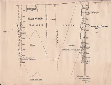
Document - MCCOLL, RANKIN AND STANISTREET COLLECTION: NAPOLEON REEF GOLD MINING CO. N.L, 1940
Document: 4 copies of plan of Transverse Section of Napoleon Anticline Lease no 10970, plan shows proposed shaft location and depth (1000 ft), for Napoleon Reef Gold Mining Co, also location and depth of adjacent Central Nell Gwynne Shaft scale 100ft = 1 inch, Prepared by J.J. Caldwell Mines Dept Bendigo.organization, business, industrial - mining, mccoll rankin & stanistreet, mining, gold mining, napoleon reef -
 Federation University Historical Collection
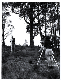
Photograph - Black and white photograph, Surveying Exercise
Two men, and a woman wearing a mini skirt undertake a surveying exercise in a bush location. It is thought to be land near the Mount Helen Campus.surveying, mount helen, mini skirt, platform shoes, desert boots, scientific instruments, student activities -
 Bendigo Military Museum
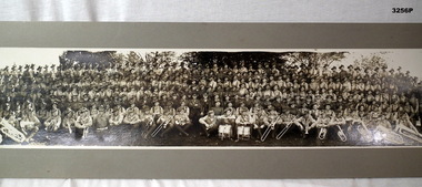
Photograph - PHOTOGRAPH, FRAMED, possibly between the two World Wars
Black & white photo of unknown battalion with band & instruments in front line. Members are wearing puttees & boots. Trees in background. Location unknown. RHS bottom corner: "Walker Photo"photography-photographs, military history-army -
 Mission to Seafarers Victoria
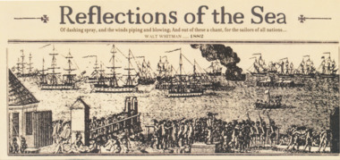
Flyer, Reflections of the Sea Opening Night, 2013
Reflections of the Sea was an exhibition of 10 framed montage of photographs from the mission's archive collection showcasing 10 stained glass windows from the St Peter chapel. This exhibition curated by Georgia Melville and Catherine McLay, and funded by PROV and Creative Victoria, was displayed in the World Trade Centre Wharf Gallery in June-July 2013 (opening night 17 June 2013) and toured to Queenscliff Maritime Museum. The photographs of the windows were taken by scientific photographer Justine M. Philip.For over 150 years the Mission to Seafarers in Victoria has continued to meet the welfare needs of seafarers who arrive on Australian shores from around the world. This exhibition presents a selection of stained glass windows and historical photographs from the Mission, to capture a glimpse of some of the people and scenes integrale to this relationship.Cream colour double sided flyer with title of the exhibition, a quote by Walt Whitman, at the back: statement, date and location of the opening exhibition and sponsorsreflections of the sea, georgia melville, exhibition, 2013, world trade centre, wtc, justine m. philip, mission to seafarers, flinders street, creative victoria, prov, stained glass windows, arthouse, catherine mclay -
Glenelg Shire Council Cultural Collection
Document - Flyer - Promotional material for Portland Victoria, n.d
DL flyer, bi-fold, advertising Portland as a place for industrialists to invest in. Textured paper, full colour photographs of Portland and location map.portland industry -
Glenelg Shire Council Cultural Collection
Photograph, n.d
Black and white photo. Group of men sitting/standing outdoors on wooden sleepers. No firearms, but location same as 7767, 7768. Same club -
 Bendigo Historical Society Inc.
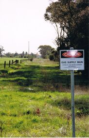
Photograph - CASTLEMAINE GAS COMPANY COLLECTION: PHOTO PADDOCK, 20/07/1999
Photo of a paddock with a sign at right ''Caution Gas Supply Main'' date stamp at bottom left 20/07/1999. Location unknownKodakplace, land, paddock -
 Bendigo Historical Society Inc.
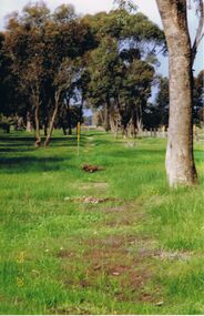
Photograph - CASTLEMAINE GAS COMPANY COLLECTION: PHOTO PADDOCK, 20/07/1999
Photo of paddock with a trench line marked, a yellow and gray marker at the centre. Date stamp at bottom 20/07/1999. Location unknown.Kodakplace, land, paddock -
 Bendigo Historical Society Inc.
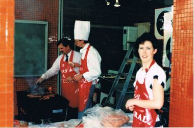
Photograph - CASTLEMAINE GAS COMPANY COLLECTION: PHOTO PEOPLE, 1987
1987 Cooking school's competition - Lady in red apron, 2 man in red apron cooking one in chef hat. Location Unknown.Kodakevent, entertainment, school's cooking competition -
 Bendigo Historical Society Inc.
Photograph - CASTLEMAINE GAS COMPANY COLLECTION: PHOTO FEMALE
Gas and Fuel Fashion,Food,Fitness. Female in a one piece swim costume, black and white vertical stripes. Date and location unknown.event, social, gas & fuel fashion, food, fitness -
 Bendigo Historical Society Inc.
Photograph - CASTLEMAINE GAS COMPANY COLLECTION: PHOTO PEOPLE
Gas and Fuel Fashion,Food,Fitness. 2 females and 1 male on stage parading collection of winter clothes. Date and location unknown.event, social, gas & fuel fashion, food, fitness -
 Bendigo Historical Society Inc.
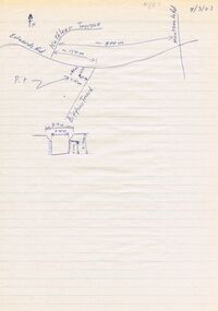
Document - DWYER COLLECTION: DRAWINGS MAPS AND PHOTOGRAPHS OF STONE WELL MAIDEN GULLY
Map on lined writing paper, showing location of stone well in Maiden Gully, on Biffins Track, off Edward Rd., Maiden Gully.bendigo, buildings, stone well map -
Port Melbourne Historical & Preservation Society
Photograph - Yarra River, Ron Laing, 1990s
Part of Ron Laing's collection of photographs recording Port Melbourne over a thirteen year period. Donated to the PMH&PS by the photographer. nb Includes photographs of Victoria Dock in the period of time after the commercial shipping had gone but before the start of the proposed high-rises. The Bolte Bridge which caused this closure of Victoria Dock, North and South Wharves is covered in photos 1319.01-.35.A set of 47 colour photogaphs of the Yarra River at various locations from the old Sandridge Railway Bridge westward to the power house at Newportyarra river, built environment, transport - shipping, ron laing -
Port Melbourne Historical & Preservation Society
Photograph - Various night/evening views, Port Melbourne. West Gate bridge, Ron Laing, 1990s
Part of Ron LAING's collection of photographs recording Port Melbourne over a thirteen year period. Donated to the PMH&PS by the photographer.One of a set of 35 colour photogaphs of evening and night shots taken at various locations in Port Melbourne. West Gate Bridge at nightron laing, engineering - bridges, west gate bridge -
Port Melbourne Historical & Preservation Society
Photograph - Various night/evening views, Port Melbourne Bay street, Ron Laing, 1990s
Part of Ron Laing's collection of photographs recording Port Melbourne over a thirteen year period. Donated to the PMH&PS by the photographer.One of a set of 35 colour photogaphs of evening and night shots taken at various locations in Port Melbourne Bay street towards the citybay street, port melbourne town hall, built environment - civic, ron laing -
Port Melbourne Historical & Preservation Society
Photograph - Various night/evening views, Port Melbourne Albert Street early morning, Ron Laing, 1990s
Part of Ron Laing's collection of photographs recording Port Melbourne over a thirteen year period. Donated to the PMH&PS by the photographer.One of a set of 35 colour photogaphs of evening and night shots taken at various locations in Port Melbourne Albert Street early morningron laing, albert street -
 National Vietnam Veterans Museum (NVVM)
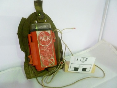
Equipment - Equipment, Army, Strobe Light
Strobe light, orange in colour. Complete with khaki holder. Used for location for night flight aircraft Made by ACR for Firefly Rescue LiteNo 161 112/2/0strobe light, sas -
Port Melbourne Historical & Preservation Society
Photograph - Russian trawler, Tavrida, 28 South Wharf, 1990s
From set of four (4) photographs of ships in various locations in Port Melbourne. (.03) Tavrida, Russian Trawler, 28 South Wharftransport - shipping, travida, south wharf -
 Bendigo Historical Society Inc.
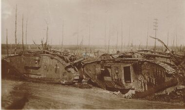
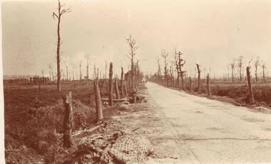
Postcard - ACC LOCK COLLECTION: SEPIA PHOTO OF TWO DESTROYED TANKS, POSTCARD, 1914-1918
Postcard, WW1, sepia photo of two destroyed tanks. Defoliated trees in background. Location not known. Handwritten in pencil on the back - G33 and GSpostcard, postcard, ww1, tanks, france -
 Bendigo Historical Society Inc.
Postcard - ACC LOCK COLLECTION: SEPIA PHOTO OF ROADWAY WITH DEFOLIATED TREES, POSTCARD, 1914-1918
Postcard, WW1, Sepia photo of a roadway with defoliated trees on either side. Rubbish on left side. Two vehicles in the distance. Location not known.postcard, postcard, ww1, france -
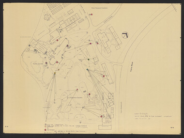
Bendigo Historical Society Inc.
Map - BIG 180 SHAFT POSITION, No date visible
Map: Plan showing the location of various shafts in the Victoria Hill area, hand draughted in pencil. Scale 2 Chains to 1 inchmap, bendigo, mining plan, mining , gold mines. victoria hill, big 180 -
 Whitehorse Historical Society Inc.
Photograph, Daniel Robertson Australia Pty Ltd, 2014
Englishman John Robertson was a roofing contractor and importer of slate. He founded the Daniel Robertson company in 1835 after arriving in Australia on a ship that carried a large quantity of slate as ballast. This slate was soon seen on the roofs of important Melbourne buildings. In 1910 the company began producing concrete roof tiles in South Melbourne, and in 1928 they converted the Tunstall Brickworks to produce terracotta tiles. In 1967 Daniel Robertson's produced a unique rustic range of bricks that were such a success that the roof tiles were phased out in 1969. In 2013 Daniel Robertson Australia Pty Ltd closed. These 2014 photographs show the buildings and some products still on the site at the time.13 coloured photographs of the office, storage and kiln areas at the Daniel Robertson site in 2014. Location is 58 - 74 Station Street, Nunawading.daniel robertson australia pty ltd, clay products, bricks and tiles -
 Bendigo Historical Society Inc.
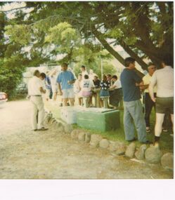
Photograph - CASTLEMAINE GAS COMPANY COLLECTION: PHOTO PEOPLE
Christmas Party Date and Location Unknown - Several People Standing outside Chatting and Drinking plus several more sitting at a wooden TablePolaroidperson, group, christmas party -
 Bendigo Historical Society Inc.
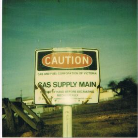
Photograph - CASTLEMAINE GAS COMPANY COLLECTION: PHOTO CAUTION SIGN
Caution Sign Gas and Fuel Corporation of Victoria - Gas Supply Main - Expose by Hand Before Excavating Mechanically - Location and Date UnknownPolaroidorganisation, industry, gas and fuel -
 Kew Historical Society Inc
Photograph - Yarra in Flood, 1934
Flooding of the Yarra Valley, including that section of the Yarra bordering Kew and Kew East in the north and west of the municipality, was a regular occurrence. Extreme flood events of the Yarra River are recorded to have occurred in 1891, 1901, 1916, 1923 and 1934. The Municipality of Kew's response to these floods was to enact planning decisions restricting residential development in flood prone areas following the floods of 1916, 1921 and 1934. While floods continued after the development of the Upper Yarra Reservoir (construction 1948-57), the regularity and extent of these inundations diminished.Black and white print positive. 1934 floods of the Yarra Valley. Location Fairfield looking towards wooded hillside. Houses floating in river.Reverse: "From Fairfield Park (11936?) back towards hill (Wurundjeri Spur?)"floods -- 1934, yarra valley, yarra river, fairfield park -
 University of Melbourne, Burnley Campus Archives
Plan, VCAH -Burnley: Sluice Valve, Tap & Fire Hydrant Locations, c. 1987
Plan showing locations and instructions for use, hand drawn. "Overlay onto SP1 Plan 1/1987," handwritten on it. Plan same as 11.0715.vcah, sluice valves, taps, fire hydrants