Showing 25579 items matching "plenty-township-estate"
-
 Ringwood and District Historical Society
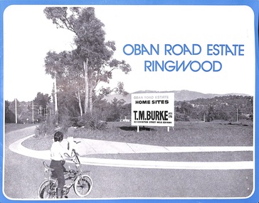
Flyer, Land Sale Advertisement, Oban Road Estate, Ringwood, Vic. - 1974
Double-sided folded page with blue border advertising sale of Oban Road Estate Ringwood building allotments. Front page features photograph of view from the estate towards Dandenong Ranges. Centrefold pages include terms of sale, layout and features of the subdivision, and summary of local services. Photocopy of typewritten price list for the 52 lots also attached.Subdivision includes Oban Road, Ambrie Avenue, Hendra Grove, and Mullum Mullum Road. (Agent) T.M. Burke Pty Ltd., 63 Exhibition Street Melbourne, Telephone 654 4144. -
 City of Moorabbin Historical Society (Operating the Box Cottage Museum)
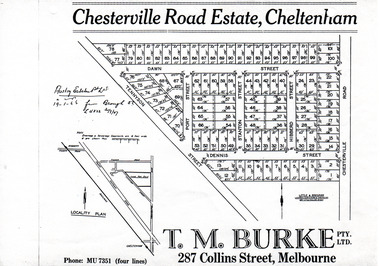
Flyer - Chesterville Road Estate, Cheltenham, 1947
Chesterville Road Estate, consisting of 101 building lots, was sold by private sale in late 1947.Example of the progress of the Municipality of MoorabbinPhotocopy of advertising flyer for sale of real estate sales - plan of building blocks for saleChesterville Road Estate, Cheltenham - plan of subdivisiontennyson street, port street, dennis street, station street, dawn street, hubbard street, chesterville road, cheltenham, real estate, auction -
 Ringwood and District Historical Society
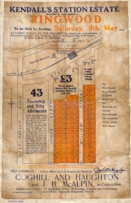
Flyer, Auction Sale Advertisements - Kendall's Station Estate, Ringwood, Victoria - 1914
Advertisements for auction sale on Saturday, 9th May (1914) 43 township and villa allotments directly opposite the railway station, showing terms of sale and subdivision layout. Un-named newspaper clipping advertising this auction also attached.Subdivision includes James Street and William Street (later Kendall Street), Ringwood. Agents in conjunction - Coghill & Haughton and J.B. McAlpin. Sale by order of Mrs. E. Kendall. -
 Greensborough Historical Society
Slide - Photograph, John Ramsdale, Ford over Plenty River to Partington's Flat: Slide 72, 1990s
Photograph shows road or path over culvert. This is the ford over Plenty River to Partington's FlatPart of the John Ramsdale collection of slides and audio visual material.Colour photograph scanned from slide.No caption. Printed maker's mark on slide "Kodak Kodachrome Slide"ford over plenty river, plenty river, partington's flat -
 Greensborough Historical Society
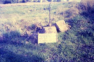
Slide - Photograph, John Ramsdale, Plenty Gorge sign: Slide 50, 1990s
Photograph shows a sign accusing MMBW of taking land for mega park - Plenty Gorge ParkPart of the John Ramsdale collection of slides and audio visual material.Colour photograph scanned from slide.No maker's marks. No caption on slide.plenty gorge metropolitan park, plenty gorge, melbourne and metropolitan board of works -
 Greensborough Historical Society
Slide - Photograph, John Ramsdale, Upper Plenty, possibly Yan Yean: Slide 56, 1990s
Photograph shows a rural scene after rain. The upper Plenty, possibly around Yan Yean.Part of the John Ramsdale collection of slides and audio visual material.Colour photograph scanned from slide.No maker's marks. No caption on slide.plenty river, yan yean -
 Greensborough Historical Society
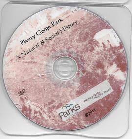
DVD, Plenty Gorge Park: a natural and social history / Parks Victoria, 2011_
This DVD gives some detail of the Plenty Gorge Park, its natural environment and impact of man.1 DVD. plenty gorge park, parks victoria, plenty river -
 Greensborough Historical Society
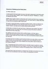
Document, Bill Cecil, Memories of walking up the Plenty River, by William (Bill) Cecil, 1950o
Bill Cecil remembers activities from his youth including rabbit hunting on the Plenty River1 page, typescriptplenty river, bill cecil -
 Greensborough Historical Society
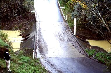
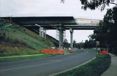
Photograph - Digital image, Frank Solomon, Plenty River Drive Bridge Roadworks 1, 1995c
These photos show the duplication of the bridge over Plenty River Drive on the Greensborough Bypass, circa 1995.Digital copy of colour photographplenty river drive, greensborough bypass -
 Greensborough Historical Society
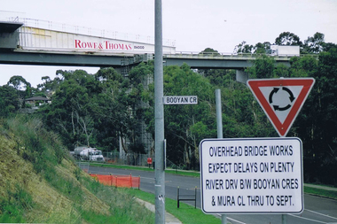
Photograph - Digital image, Frank Solomon, Plenty River Drive roadworks 2, 2005c
These photos show the duplication of the bridge over Plenty River Drive on the Greensborough Bypass, circa 2005.Digital copy of colour photographplenty river drive, greensborough bypass -
 Greensborough Historical Society
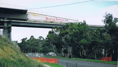
Photograph - Digital image, Frank Solomon, Plenty River Drive Bridge Roadworks 3, 2005c
These photos show the duplication of the bridge over Plenty River Drive on the Greensborough Bypass, circa 2005.Digital copy of colour photographplenty river drive, greensborough bypass -
 Greensborough Historical Society
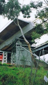
Photograph - Digital image, Frank Solomon, Plenty River Drive Bridge Roadworks 4, 2005c
These photos show the duplication of the bridge over Plenty River Drive on the Greensborough Bypass, circa 2005.Digital copy of colour photographplenty river drive, greensborough bypass -
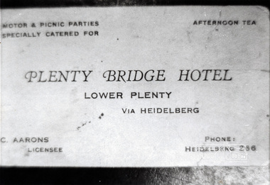 Eltham District Historical Society Inc
Photograph, Business card, Plenty Bridge Hotel, c.1930s-c.1940s
Business card for Plenty Bridge Hotel, C. Aarons, licensee, c.1930s-c.1940sBlack and white photographlower plenty, hotels, plenty bridge hotel, advertisements, c. aarons, bridges -
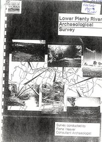 Greensborough Historical Society
Report, Lower Plenty River Archaeological Survey; Fiona Weaver, 1989_
Archaeological survey of the Lower Plenty River undertaken in 1989-1990 by Fiona Weaver for the Board of Works. Indigenous heritage sites along the Plenty River are examined and recommendations made for the preservation and to lessen the impact of development on these sites.Printed on white A4 paper. Approx 92 pages (not numbered). Illus., maps. 2 copies.plenty river, board of works, aboriginal heritage sites, fiona weaver -
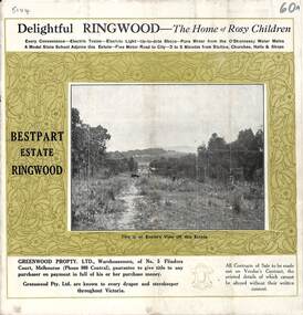 Ringwood and District Historical Society
Pamphlet, Land Sale Brochure, Bestpart Estate, Ringwood - circa 1925
Twelve page land sale brochure including photographs, subdivision features and local facilities. Additional flyer with conditions of sale and prices for estate blocks.Subdivision plan includes Bedford Road, Greenwood Avenue, Caroline Street, Wilanna Street, Henry Street, Haig Street -
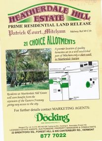 Whitehorse Historical Society Inc.
Document, Heatherdale Hill Estate, 1994
Sale brochure for 'Heatherdale Hill Estate',Sale brochure for 'Heatherdale Hill Estate', Patrick Court, Mitcham, 1994. Agents: M.J. Docking and Associates. On the site of the old Heatherdale Primary School.Sale brochure for 'Heatherdale Hill Estate',heatherdale hill estate, mitcham, good governs street, patrick court, purches street, heatherdale primary school, land subdivision -
 Whitehorse Historical Society Inc.
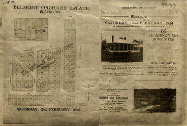
Document, Belmont Orchard Estate, 1924
Brochure for auction of Belmont Orchard Estate, BlackburnBrochure for auction of Belmont Orchard Estate, Blackburn, (now Nunawading) 66 sites, 2 February 1924. Agents: Coghill & Haughton, Frank Fisher.Brochure for auction of Belmont Orchard Estate, Blackburnauctions, belmont orchard estate, patterson street, nunawading, central road, joyce street, lilian street, west avenue -
 Whitehorse Historical Society Inc.
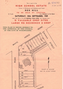
Document, High School Estate, 1949
Advertisement for High School Estate,Advertisement for High School Estate, Box Hill auction on 24/9/1949 of residence and shop and 15 shop sites including plan of development.Advertisement for High School Estate, auctions, high school estate box hill, middleborough road, box hill, flora avenue, whitehorse road -
 Greensborough Historical Society
Photograph - Digital image, Frank Robinson, Looking north over the football ground with bridge over Plenty River, 1954_
Looking north over the football ground with bridge over Plenty River. The Blackjack property, house and acres of fruit orchards ran down to the Plenty River off Hume Street Greensborough and was the home of the Robinson family to late 1956. The photographs were taken as slides by Frank Robinson and digitised by his son James in 2015.Digital copy of colour photgraph.robinson family, blackjack, plenty river -
 Greensborough Historical Society
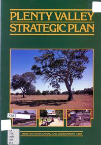
Booklet - Leaflet, Plenty Valley strategic plan, August 1989
A 1989 planning document for the Plenty Valley growth area, as much of it moved from rural to residential zoning.8 p., text and col. illustrationsplenty valley, urban development, plenty river, shire of diamond valley, whittlesea -
 Greensborough Historical Society
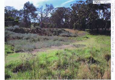
Photograph - Photograph (Copy), Anne Paul, Lot 2A Main Road Lower Plenty, 2007_05
Three views of entry into Lot 2A Main Road Lower Plenty, now Edward Willis Drive.3 colour photographs printed on paper, handwritten captionslower plenty, main road lower plenty, edward willis drive lower plenty -
 Greensborough Historical Society
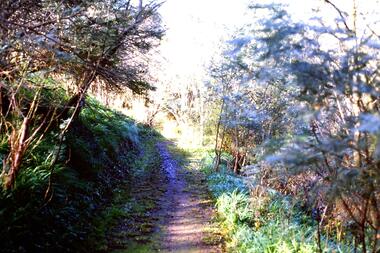
Slide - Photograph, John Ramsdale, Along Plenty River near Para Road: Slide 86, 1990s
Photograph shows a track through bushland, along the Plenty River near Para Road, possibly Montmorency.Part of the John Ramsdale collection of slides and audio visual material.Colour photograph scanned from slide.No maker's marks. No caption on slide.plenty river, para road montmorency, bushland -
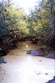
 Greensborough Historical Society
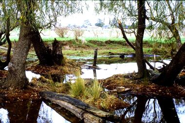
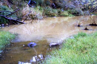
Slide - Photograph, John Ramsdale, Muddy Plenty River: Slide 93, 1990s
Photograph shows a muddy Plenty River with a small creek entering the river. Note the dumped car in background.Part of the John Ramsdale collection of slides and audio visual material.Colour photograph scanned from slide.No maker's marks. No caption on slide.plenty river, pollution -
 Greensborough Historical Society
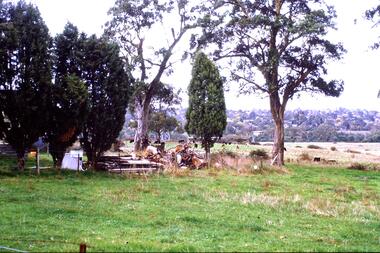
Slide - Photograph, John Ramsdale, Farmland, Lower Plenty: Slide 116, 1990s
Photograph shows a rural scene - a farmyard with stacked wood and disused farm equipment - in Lower Plenty, 1990s.Part of the John Ramsdale collection of slides and audio visual material.Colour photograph scanned from slide.No maker's marks. No caption on slide.lower plenty, farms -
 Greensborough Historical Society
Slide - Photograph, John Ramsdale, Looking towards Bulleen from Lower Plenty; Slide 115, 1990s
Photograph shows a rural scene with gum tree and pylon, looking towards Bulleen from Lower Plenty.Part of the John Ramsdale collection of slides and audio visual material.Colour photograph scanned from slide.No caption. Printed maker's mark on slide "Kodak Kodachrome Slide"bulleen, lower plenty -
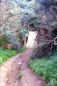 Greensborough Historical Society
Slide - Photograph, John Ramsdale, Crossing Plenty River: Slide 12, 1990s
Photograph shows erosion on a path to a footbridge over the Plenty River down from George Court Montmorency.Part of the John Ramsdale collection of slides and audio visual material.Colour photograph scanned from slide.No maker's marks. No caption on slide.plenty river, erosion, montmorency -
 Greensborough Historical Society
Slide - Photograph, John Ramsdale, Plenty River with European trees: Slide 24, 1990s
Photograph shows a section of the Plenty River with European trees and clay run-off from building nearby.Part of the John Ramsdale collection of slides and audio visual material.Colour photograph scanned from slide.No maker's marks. No caption on slide.plenty river, vegetation -
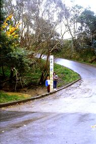 Greensborough Historical Society
Slide - Photograph, John Ramsdale, Ford over Plenty River at Partington's Flat: Slide 52, 1990s
Photograph shows 2 children with flood height marker at the ford over Plenty River at Partington's FlatPart of the John Ramsdale collection of slides and audio visual material.Colour photograph scanned from slide.No maker's marks. No caption on slide.partingtons flat, ford over plenty river, plenty river -
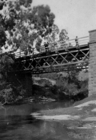 Greensborough Historical Society
Photograph - Digital image, Bridge over Plenty River, 1930-1940
Photograph of old bluestone bridge over the Plenty River in Greensborough. This photo is from the Lorraine Coates Collection.Digital copy of black and white photograph.plenty river greensborough, bluestone bridge greensborough -
 Greensborough Historical Society
Photograph - Digital Image, Plenty River in flood 1972 (1), 1972_
Plenty River in flood near Greensborough. There were two major floods in Greensborough at the time, 1972 and 1974.Digital copy of black and white photograph.plenty river, floods