Showing 1006 items
matching pound house
-
 Bendigo Historical Society Inc.
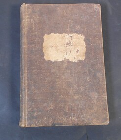
Administrative record - Index Book
Brown cover book. The pages have what looks like a name (possibly German) and columns for date, a description and price. The descriptions are in a very difficult to read handwriting. The dates are from 1862 to 1866. Also inside a promissory note: due February 15, 1907. Eight pounds thirteen shillings, November 12, 1906. three months after the date I promise to pay W.S. Friend and Co. or order the sum of eight pounds thirteen shillings. Payable at. Impossible to establish a connection between the note and the book.Label on the front, the only readable part is the date of 1860.promissory note, german -
 Bendigo Historical Society Inc.
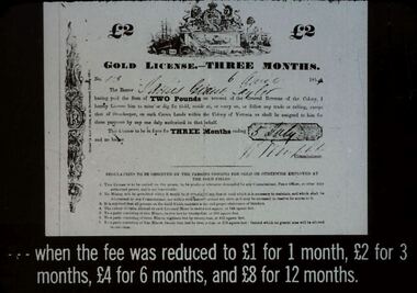
Slide - DIGGERS & MINING. THE GOLD LICENCE, c1864
Diggers & Mining. The gold licence. The Government Camp.. When the fee was reduced to 1 pound for 1 month, 2 pounds for 3 months, 4 pounds for 6 months, and 8 pounds for 12 months. Slide shows a Gold licence for 3 months. Issued 6 April 1864. Markings:4 994.LIF:4. Used as a teaching aid.hanimounteducation, tertiary, goldfields -
 Bendigo Historical Society Inc.
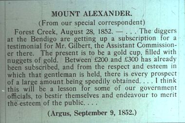
Slide - DIGGERS & MINING. THE DIGGINGS THE DIGGERS, c9 Sep 1852
Diggers & Mining. The Diggings The Diggers. Slide: MOUNT ALEXANDER. (From our special correspondent) Forest Creek, August 28, 1852. - . . . The diggers at the Bendigo are getting up a subscription for a testimonial for Mr. Gilbert, the Assistant Commissioner there. The present is to be a gold cup, filled with nuggets of gold. Between 200 pounds and 300 pounds has already been subscribed, and from the respect and esteem in which that gentleman is held, there is every prospect of a large amount being speedily obtained . . . I think this will be a lesson for some of our government officials, to bestir themselves and endeavour to merit the esteem of the public. . . . (Argus, September 9, 1852.) Markings: 77 994.LIF:4. Used as a teaching aid.hanimounteducation, tertiary, goldfields -
 Bendigo Historical Society Inc.
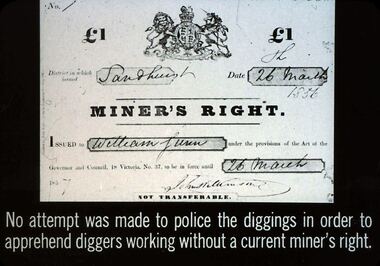
Slide - DIGGERS & MINING. THE GOLD LICENCE, 26 Mar 1856
Diggers & Mining. The gold licence. The Government Camp. Shows a copy of the 1 pound Miner's Right, issued in Sandhurst on 26 March 1856, issued to William Lunn, John Williamson and signed 26 March 1857. No attempt was made to police the diggings in order to apprehend diggers working without a current miner's right. (Note the discrepancy in the years) Markings: 42 994.LIF. 4. Used as a teaching aid.hanimounteducation, tertiary, goldfields -
 Bendigo Historical Society Inc.
Slide - DIGGERS & MINING. THE GOLD LICENCE, c1855
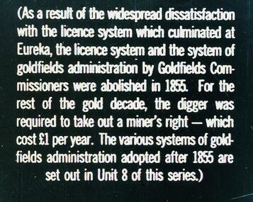
Diggers & Mining. The gold licence. The Government Camp. (As a result of the widespread dissatisfaction with the licence system which culminated at Eureka, the licence system and the system of goldfields administration by Goldfields Commissioners were abolished in 1855. For the rest of the gold decade, the digger was required to take out a miner's right - which cost 1 pound per year. The various systems of goldfields administration adopted after 1855 are set out in Unit 8 of this series.) Markings: 41 994.LIF. 4. Used as a teaching aid.hanimounteducation, tertiary, goldfields -
 Bendigo Historical Society Inc.
Document - JOHN JONES COLLECTION: RECEIPT FOR PIANO, 5th July 1920
Receipt written on both sides of a piece of paper, dated 5/7/1920 and signed by M A Lowe. Received from Mr De Ravin the sum of forth seven pounds sterling for Piano. Pale brown 2d.duty stamp attached with Received Payment £47-0-0 M A Lowe written across it.Mr A. Loweephemera, mementoes, receipt, john jones collection - receipt for piano, mr de ravin, m a lowe, mandurang state school committee, lubitz piano -
 Bendigo Historical Society Inc.
Slide - DIGGERS & MINING. STORES AT THE DIGGINGS, c1852
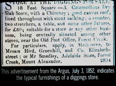
Diggers & Mining. Stores at the diggings. Store at the digging for sale: 18 Feet Square - A Commodious Slab Store, with a Chimney; good canvas roof, lined throughout with stout sacking: a counter, two stretchers, a table, and some other fixtures, for 60 Pounds; suitable for a store or any other business, being centrally situated among other stores, near the Old Post Office, Forest Creek. For particulars, apply, in Melbourne, to Messrs Hird, Greenhill, and Co. Elizabeth street: of Mr Smedley, Adelaide Store, Forest Creek, Mount Alexander. 2804. This advertisement from the Argus, July 3, 1852, indicates the typical furnishings of a diggings store. Markings: 5 994.LIF. 5. Used as a teaching aid.hanimounteducation, tertiary, goldfields -
 Bayside Gallery - Bayside City Council Art & Heritage Collection
Work on paper - ink and watercolour, Annette Meikle, Beaumaris RSL, 1977
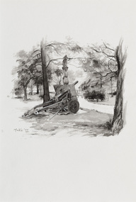
In 1977, artist Annette Meikle undertook a commission to illustrate a book recording stories of places and people in the Bayside area. It was published in 1978 as Sandringham Sketchbook, with text by Elizabeth Waters. The sketches were intended to record remaining examples of Bayside’s early architecture and environment, as well as reflect newer architectural changes. Meikle went on to donate 22 of these sketches to Bayside City Council in 2003. This gun stood in the grounds of the Beaumaris RSL, located on the highest hill in Beaumaris – more than 300 metres above sea level. The ‘25-pounder’ was one of the best field guns of its day and was used by British and Commonwealth armies during the Second World War. The original ten-acre property, which was the former holiday home of wealthy Toorak resident Langford-Jack, was sold to the Legacy Club in 1942 and operated as a holiday home for Legacy children. Renamed Blamey House in honour of Field-Marshall Sir Thomas Blamey, it was purchased by the RSL in 1955. The Beaumaris RSL Club closed its doors on Balcombe Road in 2016 after the property was sold in 2013.Annette Meikle, Beaumaris RSL 1977, ink and watercolour, 33.8 x 23.5 cm. Bayside City Council Art and Heritage Collection. Donated by the artist, 2003annette meikle, sandringham sketchbook, elizabeth waters, beaumaris rsl, 25-pounder, field gun, military weapon, langford-jack, blamey house, balcombe road, beaumaris -
 Bendigo Historical Society Inc.
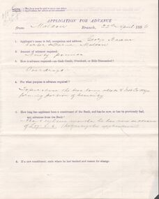
Document - Mortgage and cash credit bond
Copy of a cash credit bond between George Baxter, carter, of Maldon and the bank of New South Wales for ninety pounds. Also, an application for advance and two copies of the mortgage documents. all the documents related to purchase of land in Maldon and are dated 22 April 1896. Also, a brown envelope addressed to The Manager bank of New South Wales, Melbourne from Geo Baxter, carter, Maldon "lapsed security" Some other writing in pencil on the envelope.maldon, mortgage, freehold, baxter, cash credit bond -
 Bendigo Historical Society Inc.
Document - NEVILLE KING COLLECTION: OCCUPATION CERTIFICATE HOMESTEAD FARM NO. 15/939 IN THE NAME OF DAVID WILLIAMS AT A COST OF ONE POUND, DATED 25 SEPTEMBER 1897, 1897
Under the Western Australia 'the Homestead act 1893' an Occupation Certificate, Homestead Farm No. 15/939 for David Williams of Bendigo for 160 acres (near Woolkabunning near Bunbury WA); at a cost of one pound. Signed by order of the Commissioner of Crown Lands. Dated 25 September 1897. The land is marked and distinguished in the maps and books of the Department of Lands and Surveys of the said (WA) Colony as Williams Location No. 702. -
 Bendigo Historical Society Inc.
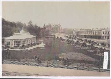
Photograph - Bendigo Conservatory and gardens
Fifty nine acres of land was reserved for a park in1861, and the first gardener began setting out the gardens in 1870. The conservatory was built in 1897 and is the last building of its type in a public park.The conservatory was designed by Mr G. Minto, city surveyor at the time. The building is 72 feet long and 24 feet wide. The walls re twenty two feet high and are topped by a lantern roof, adding a further six feet. It was built at a cost of between 700 and 800 pounds.B&W photograph with view over the Bendigo Conservatory and gardens with a line of twelve horse drawn cabs on Bridge Streetconservatory gardens, bendigo -
 Bendigo Historical Society Inc.
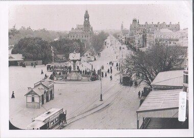
Photograph - Charing Cross and Pall Mall
View of Charing Cross and Pall Mall Bendigo, featuring the Alexandra fountain still under construction. The fountain was jointly funded by the Bendigo Juvenile Industrial Exhibition in 1879, a 500 pound donation by George Lansell and a 700 pound grant from the Sandhurst City Council. The fountain was designed by William Vahland and was opened 5/7/1881. The fountain is 28 feet tall and sits in a 2 feet deep pond that is 50 feet in diameter. It was built with 22 tons of Harcourt granite, cast iron and painted stone.8531 A4 B&W photograph of Charing Cross and Pall Mall, Bendigo, in the late 1800s (prior to automobiles); taken from the City Family Hotel. Photograph shows work underway on the Alexandra Fountain at Charing Cross. Photo shows three trams, pedestrians and some horse drawn vehicles. Pall mall shows Post Office, Shamrock hotel and TAFE towers.charing cross, post office -
 Bendigo Historical Society Inc.
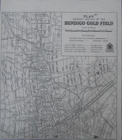
Map - Bendigo Gold Field
Plan showing portion of the Bendigo goldfield. Area of main goldfield: 140 square miles. Deepest mine working: 4593' (Victoria quartz). Gold output of field to 1935: 20,775,000 ounces. Dividends paid 1870-1935: 10,740,000 pounds.map, goldfield, bendigo -
 Bendigo Historical Society Inc.
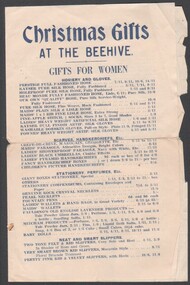
Flyer - Christmas Gifts at the Beehive
Early 1950s items and costs (in pounds shillings and pence) pre-decimal charges for itemised gifts. Beehive buildings. This was originally the Sandhust Mining Exchange and as such was the oldest purpose built exchange in Australia and was one of only two in regional Australia. It was initially established in the 1850's to service the miners of the area. It's first double story incarnation as the Bendigo Stock Exchange, contained up to 2000 stockbrokers and 5000 shareholders. In 1871 the building burnt to the ground and the new and current building was completed in 1872. The modern building was designed by Charles Webb, who was also responsible for the Royal Arcade in Melbourne. and features a pitched glass roof similar to the Royal Arcade, Melbourne.Christmas Gifts at the Beehive - a shopping flyer for the Beehive department store, circa early 1950s. the flyer covers Christmas gifts across the various departments of the Beehive Store in Pall mall and Hargreaves Street Bendigo. Two-page folded flyer, black printed on cream paper. Printed by Cambridge Press, Bendigo. Early 1950s items and costs (in pounds shillings and pence) pre-decimal charges for itemised gifts.the beehive, christmas gifts -
 Bendigo Historical Society Inc.
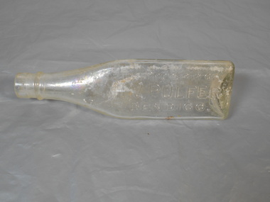
Domestic object - Bottle
Harold Victor Pulfer was born in Bendigo in 1887 and died 8/12/1940. He lived at 12 Brougham St., Quarry Hill. At the time of his death he was listed as a merchant and left an estate worth 11,782 pounds. By 1912 he was trading as Hamilton and Pulfer from a business in Hargreaves Street, Bendigo. As well as manufacturing tomato sauce they were also general merchants selling everything from herrings to poultry remedies.Bottle triangle shape The Property of H.V Pulfer Bendigo . This Property must not be used as a Food Container. L203 AGMglass, bottle -
 Bendigo Historical Society Inc.
Letter - MCCOLL, RANKIN AND STANISTREET COLLECTION: MONUMENT HILL AND DEBORAH GOLD MINES
Letter, 26 June 1931, 'Dear Herb', signed by Harris (unclear) with two quotes attached to bale water from the Monument Gold Mine and Deborah Gold Mines. Monument Gold Mining Co. Incoming water is four thousand gallons per day, baling in three shifts, the 'water would be off the bottom plat in three weeks' Cost - firewood 60, engine drivers wages 40, stokers, 28, total 128 pounds. Deborah Gold Mine.Baling three shifts, the water would be off the bottom plat at the outside, in two weeks. Cost firewood 40, engine drivers wage 26, stokers 18, total 84 pounds. Signed H.E. Jones, Mine Manager.`bendigo, gold mining, mccoll rankin and stanistreet, bendigo gold mining, monument hill gold mine, deborah gold mine, h.e. jones, mine manager, engine driver -
Bendigo Historical Society Inc.
Letter - MCCOLL, RANKIN AND STANISTREET COLLECTION:CAMERON SUTHERLAND SEWARD TO STANISTREET ESQ
Letter Cameron Sutherland Seward Pty Ltd., 26 May 1931 to J.J.Stanistreet Esq, Commonwealth Bank Buildings, Charing Cross, Bendigo re quotes from Mr. Bloomfield 'in connection with the Deborah, Monument Hill and Central Nell Gwynne Mines. Deborah Mine: horizontal steam driven air compressor, air receiver - price 45 pounds. Steam mining winches, Cornish boiler, Lancashire Jackass boiler, Cornish Flue Boiler (Roberts) funnels for boilers, exhaust tanks, quartz hoppers, poppet heads.bendigo, gold mining, mccoll rankin and stanistreet, bendigo, monument hill gold mine, deborah gold mine, central nell gwynne gold mine, g. seward, j.j. stanistreet, cameron, sutherland and seward pty ltd. -
Bendigo Historical Society Inc.
Letter - MCCOLL, RANKIN AND STANISTREET COLLECTION: QUOTE FROM MILLER AND CO. MACHINERY, 25th May 1931
Five page letter and quote, 25th May 1931, from Miller & Co Machinery, 27 Queen Street, South Melbourne. Bendigo office phone 50. Quote for Central Nell Gwynne shaft: steam winch, straight line steam drive air compressor, air receiver, Cornish flue boiler, Worthington duplex steam pump. Price for foregoing 740 pounds. Delivery of boiler at Redan shaft, poppet legs standing at Buttrey's Reward Mine and the whole of the balance of the plant F.O.R. Melbourne Monument Hill Shaft: steam winch double cylinder, straight line single stage steam driven air compressor, air receiver crown flanged ends, Cornish flue boiler, steam pipes, air pipes, iron chimney stack 26'0' x 3'.6' diameter, black steel wire ropes 1000' length Price for foregoing 610 pounds. If preferred, self contained boiler in lieu of Cornish type offered, the following is offered: return tube boiler, by Roberts and Sons Bendigo. This boiler is self contained Deborah shaft: straight line steam driven air compressor, air receiver. Price 200 pounds.bendigo, gold mining, mccoll rankin and stanistreet, miller and co., machinery., central nell gwynne gold mine, monument hill gold mine -
 Bendigo Historical Society Inc.
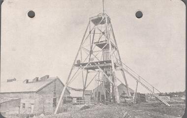
Postcard - POSTCARD. GREAT EXTENDERED HUSTLERS, 1865
Postcard. ROYAL HISTORICAL SOCIETY OF VICTORIA. Bendigo Branch Great Great Extended Hustlers. Locality. Hustlers Hill, Nth Bendigo Formed 1865 - Last production 1921 Depth of Shaft - 3470 feet Poppet Legs - Steel, 70 feet high Winding Engine: First motion 8ft. Drums. Golde Very Rich Total yield - 300,000 ozs. Dividends pounds 375,000 -
 Bendigo Historical Society Inc.
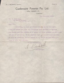
Certificate - LETTER FROM CASTLEMAINE POTTERIES PTY. LTD. TO MR R. WHITTING OFFERING HIM A POSITION, DATED 3RD DECEMBER 1920
Letter from Castlemaine Potteries Pty. Ltd. To Mr R. Whitting offering him a position, dated 3rd December 1920; signed H. S. Archdall, Secretary. Letter on castlemaine Potteries Pty. Ltd. paper The position is offered as Packer and Time Keeper at a salary of three pounds ten shillings per week. -
Bendigo Historical Society Inc.
Letter - LYDIA CHANCELLOR COLLECTION: GOLDEN SQUARE METHODIST CHURCH DONATION APPEAL LETTER, DEBTOR SHEET AND YEARLT DEBT SHEET, 1923
LYDIA CHANCELLOR COLLECTION: GOLDEN SQUARE METHODIST CHURCH DONATION APPEAL LETTER, Debtor sheet and yearly debt sheet A Jubilee Appeal Letter 1873-1923 when the church had reduced its debt to 800 pounds.bendigo, history, churches, lydia chancellor, donation -
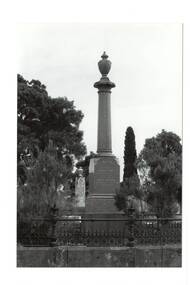 Buninyong & District Historical Society
Photograph - Original B/W Photograph, Clive Brooks, Buninyong Cemetery, Monument for George Innes and his daughter, 9/4/1994
Part of series to record changes in BuninyongGrave of Buninyong Pioneer.A B/W and a colour photo, monument, polished granite, pillar on engraved plinth, urn cap, cast iron fence, for early settler George Innes and his daughter.. in Buninyong Cemetery.buninyong, cemetery, headstone, graves, innes, king of splitters, pound, buninyong defiance mine -
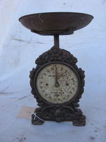 Arapiles Historical Society
Scales
House hold item, to weigh upto 20 pounds, clock facescales, balance, scale, weigh -
 Kew Historical Society Inc
Plan - Subdivision Plan, H C Crouch, Old Golf Links Estate, 1930s
The land in North Kew between the Outer Circle Railway and the River Yarra was released in sections. This release included 80 lots. Most of this area was released during the Depression years in the early 1930s.Subdivision plans are historically important documents used as evidence of the growth of suburbs in Australia. They frequently provide information about when the land was sold on which a built structure was subsequently constructed as well as evidence relating to surveyors and real estate and financial agents. The numerous subdivision plans in the Kew Historical Society's collection represent working documents, ranging from the initial sketches made in planning a subdivision to printed plans on which auctioneers or agents listed the prices for which individual lots were sold. In a number of cases, the reverse of a subdivision plan in the collection includes a photograph of a house that was also for sale by the agent. These photographs provide significant heritage information relating house design and decoration, fencing and household gardens.One part of a massive subdivision of the Old Golf Links Estate in North Kew of 80 allotments bordering Sutherland Avenue, Ramsay Avenue, Belford Road, Beresford Street and Coleman Avenue. Inset on the plan at the top left, the route of the Outer Circle Railway is clearly marked. The Kew Golf Links is identified in its current location. The land on which Greenacres Golf Club was to be constructed is at this time marked as ‘Recreation Ground’. The ‘new bridge’ over the Yarra at Burke Road is also marked on the inset map. The Plan identifies the surveyor (sic) H.C. Crouch BCE MVIS, 443 Little Collins St., Melbourne. The date of the subdivision auction sale in identified as Saturday September 25th at three o'clock.Annotations: "E" top left. "Golf Links" top right. Lots 73-76 ticked and listed as "6" poundssubdivisions -- kew (vic.), old golf links estate -
 Kew Historical Society Inc
Photograph - 8 roomed DF Brick Villa, Kew, J E Barnes, c.1920
Subdivision plans are historically important documents used as evidence of the growth of suburbs in Australia. They frequently provide information about when the land was sold on which a built structure was subsequently constructed as well as evidence relating to surveyors and real estate and financial agents. The numerous subdivision plans in the Kew Historical Society's collection represent working documents, ranging from the initial sketches made in planning a subdivision to printed plans on which auctioneers or agents listed the prices for which individual lots were sold. In a number of cases, the reverse of a subdivision plan in the collection includes a photograph of a house that was also for sale by the agent. These photographs provide significant heritage information relating house design and decoration, fencing and household gardens. The photograph is of additional aesthetic significance as it was photographed by J. E. Barnes. Josiah Earl Barnes is a nationally significant photographer. He was also the most important photographer to have worked in Kew. He was active as a photographer in the district from c.1906 until his death in 1921. Best known as 'the Embarkation Photographer' (see the Australian War Memorial collection), J. Earl Barnes was also the official photographer employed by the Borough (and later Town, then City) of Kew. He clearly also completed commercial jobs for local businesses, as is the case in this photograph of a house for a local real estate and financial agent.A photograph, mounted on board of a double fronted Federation-era brick villa in Kew, photographed for a local real estate agent and financier by J. E. Barnes of Kew. On the reverse of the photograph is a subdivision plan for the Normanby Estate, East Kew - 2016.0039.1. As can be seen from the image, there is a large tear on the surface of the photograph.The brown card on which the photograph is mounted includes the following handwritten description, which may aid the identification of the house: "Kew, 3 minutes from tram, 8 roomed DF Brick Villa, tile roof including two attics, sleepout, bathroom, heater, E Light, Entrance Hall, double doors, leadlights, laundry, garden, lawns, land 75 x 170, 1975 pounds". Also photographers inscription on mount, lower left: J. E. Barnes / Photo / Phone 1966 Haw. KEW.j. e. barnes, josiah earl barnes, j. earl banes - photographer, architecture - federation style, houses - kew, real estate photographs -
 Kew Historical Society Inc
Photograph - W.B. Villa, Kew, c.1919
The photograph offers significant information relating to late Victorian / Federation colour schemes and fencing.The block fronted villa has a corrugated iron roof and a flat projecting verandah, ornamented with a trellis design of timber. The front window features a timber shade, mounted on brackets. The treatment of the block-fronted panels shows that there is an attempt to highlight imitation quoining through use of a darker colour. The windows and door are also in this darker shade. The front fence and gate are made of wooden pickets. It is unlikely that the photograph was taken at the time of the villa's construction given the size of the shrub/tree in the front garden.Subdivision plans are historically important documents used as evidence of the growth of suburbs in Australia. They frequently provide information about when the land was sold on which a built structure was subsequently constructed as well as evidence relating to surveyors and real estate and financial agents. The numerous subdivision plans in the Kew Historical Society's collection represent working documents, ranging from the initial sketches made in planning a subdivision to printed plans on which auctioneers or agents listed the prices for which individual lots were sold. In a number of cases, the reverse of a subdivision plan in the collection includes a photograph of a house that was also for sale by the agent. These photographs provide significant heritage information relating house design and decoration, fencing and household gardens.A real estate photograph, mounted on brown card, showing a double fronted weatherboard villa, located in Kew, Victoria. On the reverse of the photograph is a subdivision plan for the Altyre Estate.Stamped on mount: Top - "KEW. Close tram. Fine View. / W.B. Villa Containing 8 Rooms. / Up-to-date Conveniences. EL Etc." Below - "Land 40 x 165. 615 pounds. Sold"houses - kew, real estate photographs -
 Kew Historical Society Inc
Photograph - Victorian Double-fronted Brock Villa, Cotham Road, c. 1919
The Kew Historical Society's map collection includes a substantial number of real estate subdivision plans, mainly of Kew but also of surrounding suburbs in Melbourne. Most of the subdivision plans date from the 1920s and 1930s when the districts old homes and local farmland were being split up to accommodate residential growth in the postwar period. These early plans were assembled by a local firm, Jas R Mather & McMillan, which had an office in Cotham Road. Many of the plans, and sometimes photos, were annotated by the agents.Subdivision plans are historically important documents used as evidence for the growth of suburbs in Australia. They frequently provide information about when the land was sold as well as evidence relating to surveyors and real estate and financial agents. The numerous subdivision plans in the Kew Historical Society's collection represent working documents, ranging from the initial sketches made in planning a subdivision to printed plans on which auctioneers or agents listed the prices for which individual lots were sold. In a number of cases, the reverse of a subdivision plan in the collection includes a photograph of a house that was also for sale by the agent. These photographs provide significant heritage information relating house design and decoration, fencing and household gardens.The photograph may also be aesthetically significant depending o the importance of the photographic atelier.Real estate photographs of a classic double-fronted late Victorian brick villa. It central location in Cotham Road, Kew enabled the selling agent to note its proximity to the tram. With seven rooms, all ‘modern conveniences’, and land of 66×167, the house was to be sold for £1100. The villa has a number of interesting features including a pattern within the slate roof as well as the use of polychrome brickwork under the eaves and on the façade. The intricacy of the cast iron lace is emphasised by the line of projecting wooden blocks above it. The picket gate is painted a different colour to the pickets of the fence. The house has a name (illegible) that is attached to the inset cast iron lace of the central projecting gable in the veranda. Stamped on mount: "Kew. Central. Close tram. / Comfortable Brick Villa. / Containing 7 rooms / Modern conveniences: / Land 66 x 167. Sold 1100 pounds:"houses - kew, victorian villas, real estate photographs, cotham road - kew -
![7 Roomed Brick [villa]; Modern Conveniences](/media/collectors/550653872162f11fb04854aa/items/59ec3da221ea690fdc4ba793/item-media/59ec3ee521ea690fdc4d0c37/item-fit-380x285.jpg) Kew Historical Society Inc
Kew Historical Society IncPhotograph - 7 Roomed Brick [villa]; Modern Conveniences, 1920s
The Kew Historical Society's map collection includes a substantial number of real estate subdivision plans, mainly of Kew but also of surrounding suburbs in Melbourne. Most of the subdivision plans date from the 1920s and 1930s when the districts old homes and local farmland were being split up to accommodate residential growth in the postwar period. These early plans were assembled by a local firm, Jas R Mather & McMillan, which had an office in Cotham Road. Many of the plans, and sometimes photos, were annotated by the agents.Subdivision plans are historically important documents used as evidence for the growth of suburbs in Australia. They frequently provide information about when the land was sold as well as evidence relating to surveyors and real estate and financial agents. The numerous subdivision plans in the Kew Historical Society's collection represent working documents, ranging from the initial sketches made in planning a subdivision to printed plans on which auctioneers or agents listed the prices for which individual lots were sold. In a number of cases, the reverse of a subdivision plan in the collection includes a photograph of a house that was also for sale by the agent. These photographs provide significant heritage information relating house design and decoration, fencing and household gardens.The photograph may also be aesthetically significant depending on the importance of the photographic atelier.A professionally produced photograph for a local real estate agent, probably Jas. R. Mathers, Son & McMillan. The photograph is of a Federation-era bungalow, in Kew. The photo is on the reverse of a subdivision plan for the Normanby Heights Estate, Kew.The mount on which the photograph is placed includes: "Kew. 1 minute to tram. Good Position. / 7 roomed brick. Modern conveniences. / Land 60 x 135. 1100 pounds"real estate photographs, houses - kew, federation architecture -
 Kew Historical Society Inc
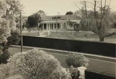
Photograph, Glendonald School for the Deaf, Marshall Avenue, 1960-1970
Glendonald School for Deaf Children was run by the Victorian Education Department. It provided education and some residential services for deaf children. The school was situated in Marshall Avenue, Kew and operated from 1951–91. Deaf children whose families lived too far to travel daily were housed in a grand Victorian mansion in Belmont Avenue, Kew, the John Cannon Hostel. The school and hostel also accommodated a small number of wards of the state. Source: Glendonald School for Deaf Children (1951–91); https://www.findingrecords.dhhs.vic.gov.au/collectionresultspage/GlendonaldSchoolforDeafChildren; Accessed 05/09/2018.Glendonald was a significant mansion in Kew (now demolished) built for the industrialist and manufacturer Donald Leslie in 1886. The school was purchased by the Victorian Department of Education on 29 November 1950 for the sum of 16,500 pounds.Photograph of the front garden of Glendonald taken from Marshall Avenue."The old school for the deaf at 17 Marshall Ave for children from the age of six years to ten years old, then they would go to 25 Marshall Ave to finish their schooling leaving age 16 years old."glendonald - marshall avenue - kew (vic), education - deaf children - victoria -
 Kew Historical Society Inc
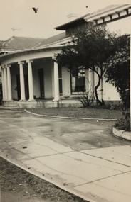
Photograph, Glendonald School for the Deaf, Marshall Avenue, 1955-1965
Glendonald School for Deaf Children was run by the Victorian Education Department. It provided education and some residential services for deaf children. The school was situated in Marshall Avenue, Kew and operated from 1951–91. Deaf children whose families lived too far to travel daily were housed in a grand Victorian mansion in Belmont Avenue, Kew, the John Cannon Hostel. The school and hostel also accommodated a small number of wards of the state. (Source: Glendonald School for Deaf Children 1951–91.)Glendonald was a significant mansion in Kew (now demolished) built for the industrialist and manufacturer Donald Leslie in 1886. The school was purchased by the Victorian Department of Education on 29 November 1950 for the sum of 16,500 pounds.Portico - entrance - of Glendonald taken from Marshall Avenue.The old school for the deaf at 17 Marshall Ave for children from the age of six years to ten years old, then they would go to 25 Marshall Ave to finish their schooling leaving age 16 years old. glendonald - marshall avenue - kew (vic), education - deaf children - victoria