Showing 1166 items matching "victoria point"
-
 Lakes Entrance Historical Society
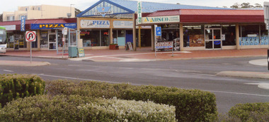
Photograph - Centre Point Arcade, 2008
... Entrance, Victoria. Photograph Centre Point Arcade ...Date made August 2008Colour photograph showing Centre Point Arcade, and retail shops on the site of the old Barkes Store, Esplanade ,Lakes Entrance, Victoria.retail trade, roads and streets, room display -
 Lakes Entrance Historical Society
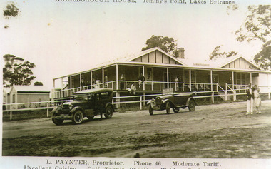
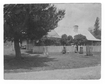
Photograph - Gainsborough House, 1925c
Gainsborough House was built of boxed poured concrete by Leslie Paynter and his father William Henry Paynter. It was opened about Christmas 1923 or 1924.Black and white photograph of Gainsborough House, Jemmys Point, showing an attractive accommodation house with veranda on front and north side. It is of concrete construction with iron roof. Guests on veranda and couple standing on road. Two soft top motor cars parked on road. Lakes Entrance VictoriaGainsborough House Jemmys Point Lakes Entrance.L Paynter, Proprietor, Phone 46, Moderate Tariff. Excellent Cuisine, Golf, Tennis, Shooting, Fishing, Surfing, Bathing.guesthouses, transport, people -
 Forests Commission Retired Personnel Association (FCRPA)
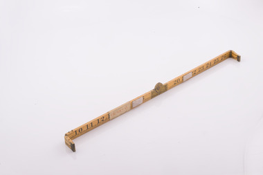
Basal Area Angle Gauge
Foresters usually measure the diameter of trees at Breast Height – traditionally 4 foot, 6 inches – now 1.3 m – which is termed Diameter Breast Height Over Bark (DBHOB). Basal Area is the cross section of the tree trunk at breast height, and the sum for the stand or group of trees is expressed square feet per acre (after 1973 it was expressed in square metres per hectare). Lots of skinny trees, or a few fat ones, can have the same Basal Area, but when combined with the number of stems, Basal Area is a good indicator of stand density. Two common methods are used to measure of Basal Area – fixed area plots and angle count sampling. 1. Fixed area plots require setting out a small area, commonly 50 m x 20 m, and measuring all the trees at breast height, and doing some quick sums. 2. Angle count sampling involves a simple sweep of the forest from a fixed sampling point using a relascope, dendrometer sight, angle gauge, or glass wedge prism. This wooden builders ruler has been shaped at one end to create a shallow angle (usually less than 3 degrees). Standing in one spot, a sweep is made with the wedge held to the eye, and trees are counted as either “in” or “out”. The number of trees is multiplied by conversion factor of the wedge (10 in this case) to estimate basal area. It’s very quick and effective.Basal Area Angle Gauge The two ends fold up and one end (on the right) has been reduced in width to create a shallow angle for the viewer Home made by cutting down a wooden builder's ruler Many forestry students made their own Basal Area Angle Gauges and its thought this may be oneforest measurement, forests commission victoria (fcv) -
 Bendigo Historical Society Inc.
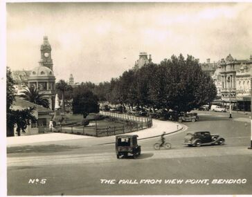
Photograph - LESLIE JOHN BAGUST COLLECTION: THE MALL, 1940
Leslie John Bagust Collection. Black & White Photo The Mall From View Point Bendigo 1940. In the foregrounds shown a van, cyclist, and car.Left of centre is the Bendigo Baby Health Centre with a white statue at its right side. The background has a white statue of Queen Victoria,part of the RSL hall and the Post Office Clock tower.Top centre above the tree line is the turret of the Shamrock Hotel. To the right is a part Streetscape of Pall Mall. Deep in the background is the tower of the School of Mines.Numerous car are parked under the trees lining the street.bendigo, tourism, the mall from view point bendigo -
 University of Melbourne, Burnley Campus Archives
Photograph - Black and white print, Royal Show 1957, 1957
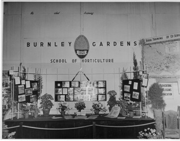
Note by T.H. Kneen 13 May1992, "The Burnley display was part of the Division of Agricultural Education's display covering Dookie, Longerenong and Burnley. Reference to Rural Training in 1957 would have been mainly to the on-farm training phase of the Rural Reconstruction Training Scheme. The Agricultural Collegians Association members had a meeting point at the exhibit. Burnley ex-students were not members of that association."Black and white photograph. Display mounted by Burnley Gardens School of Horticulture at the Royal Agricultural Show 1957. Incorporates photographs of College activities, horticultural information and a map of Victoria locating institutes offering rural training to ex-servicemen.On reverse, "Royal Show 1957."burnley gardens, school of horticulture, royal agricultural show, dookie college, rural training, rural reconstruction training scheme, the agricultural collegians association, horticulture, publicity, dept of agriculture education division, longerenong college -
 Glenelg Shire Council Cultural Collection
Booklet - Booklet - Historical Portland Souvenir, Victoria, Nov-22
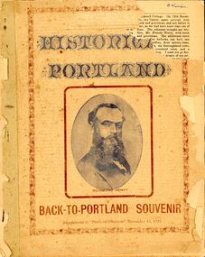
Twenty-four page booklet 'HISTORICAL PORTLAND', a Back-to-Portland souvenir supplement to 'Portland Observer', November 16, 1922. Likeness of Edward Henty on front page, Portland Bay from Battery Point, and Portland coast view from Lighthouse Point, on back. -
 Bendigo Historical Society Inc.
Photograph - 1853 Bendigo Goldfields Petition, abt 1990-2019
The Red Ribbon Movement of 1853 represented a significant series of events in the history of Bendigo. During that year there was much agitation on the Bendigo gold fields, particularly during July and August of 1853, directed against the payment of what the miners called a tax - a licence fee of thirty shillings ($3) a month for the right to search for gold on what was declared Crown land. They had to pay the licence whether they found gold or not. The miners, or diggers as they were called, also resented the means used by the authorities at the time to collect the gold licence - through so-called 'digger hunts'. The miners were expected to carry their licences with them, and the police, who were often untrained, used harsh methods to check these licences. In Bendigo, the miners took to wearing a red ribbon ‘as a symbol of their protest against the licence. Red was a very common colour in items such as shirts, so was readily available. Shopkeepers too tied red ribbons to their premises as a sign of support for the miners. It should be remembered at that time virtually everyone was a miner. The diggers also had their own banner, designed by William Dexter, a china painter from Devon. This flag showed the pick, shovel and cradle representing labour, the scales representing justice, the Roman bundle of sticks meaning unity and the kangaroo and emu of Australia Many thousands of Bendigo miners signed a petition to La Trobe, the Governor of Victoria, protesting against the licence fee. When the Governor rejected the petition, thousands of diggers marched in peaceful protest. Miners from White Hills, Eaglehawk, Golden Square, Kangaroo Flat as well as from Bendigo Flat, converged on what is now Pall Mall and View Point, surrounding the ~government camp on Camp Hill. The camp had been reinforced with soldiers of the 40 Regiment, as the Government feared bloodshed. The miners then gathered on the hill behind View Point to hear from their leaders - among them George Thomson, Captain Harrison, Captain Brown and W.D.C. Denovan. They resolved to pay a token fee often shillings ($1) for the September licence, whenthey met with Commissioners Panton and Wright on Camp Hill. Although Wright and Panton were sympathetic to the miners, the offer was rejected, but no licence fees were collected for September. Thus a possible bloody conflict was averted by the common sense shown by the miners' leaders and the commissioners. It was a truly democratic protest against arbitrary government and preceded the Eureka Stockade Incident by over a year. Bendigo Historical Society Committee on a Tram, two photos, one of five people standing behind a display cabinet, and the second one a Banner stretched across the tram. On the rear of the photo is "L-R Jim Evans, Terry Davidson, Ron Monro." Second from left is Jim Evans (President) and fourth from the left is Terry Davidson, with extreme right, Ron Munro (Vice President). In the cabinet is the 1853 Bendigo Goldfields Petition (Red Ribbon Rebellion) The society holds the petition in digital form. The diggers had their own banner, designed by William Dexter, a china painter from Devon. This flag showed the pick, shovel and cradle representing labour, the scales representing justice, the Roman bundle of sticks meaning unity and the kangaroo and emu of Australia history, bendigo, tram, 1853 bendigo goldfields petition, red ribbon rebellions -
 Glenelg Shire Council Cultural Collection
Souvenir - Souvenir Butter Dish - Portland Harbour, n.d
White china round, fluted butter dish. Transfer of 'the Harbour Portland Victoria. Scene shows Bentinck St. Baths piers and Battery Point. Dish edged in gold paint. Red Stamp on base: Crown with IBC underneath, surrounded by 'Royal scenic china made in Czechoslovakia'.souvenir of portland, portland harbour, butter dish -
Marysville & District Historical Society
Document (Item) - Research document, Judith Vimpani, JUNCTION HOTEL, 2018
A research document outlining the history of the Junction Hotel in Marysville.A research document outlining the history of the Junction Hotel in Marysville.marysville, victoria, australia, junction hotel, carlisle guesthouse, william henry kirwan, harold james robert coney, martin cussen, bridget cussen, bridget kirwan, mary ann coney, butlers woods point directory, balliere's directory, james cussen, catherine cussen, catherine dooley, the temperence, kew asylum, ararat asylum, maria catherine chester, maria catherine kirwan, william chester, golden bower mine, cumberland, james richard coney -
 Marysville & District Historical Society
Photograph (Item) - Black and white photograph, 01-12-1899
A copy of a black and white photograph of the Junction Hotel in Marysville taken in December, 1899.A copy of a black and white photograph of the Junction Hotel in Marysville taken in December, 1899.marysville, victoria, australia, junction hotel, carlisle guesthouse, william henry kirwan, harold james robert coney, martin cussen, bridget cussen, bridget kirwan, mary ann coney, butlers woods point directory, balliere's directory, james cussen, catherine cussen, catherine dooley, the temperence, kew asylum, ararat asylum, maria catherine chester, maria catherine kirwan, william chester, golden bower mine, cumberland, james richard coney -
 Marysville & District Historical Society
Photograph (Item) - Black and white photograph, c1907
A copy of a black and white photograph of the Junction Hotel in Marysville taken in 1907.A copy of a black and white photograph of the Junction Hotel in Marysville taken in 1907.marysville, victoria, australia, junction hotel, carlisle guesthouse, william henry kirwan, harold james robert coney, martin cussen, bridget cussen, bridget kirwan, mary ann coney, butlers woods point directory, balliere's directory, james cussen, catherine cussen, catherine dooley, the temperence, kew asylum, ararat asylum, maria catherine chester, maria catherine kirwan, william chester, golden bower mine, cumberland, james richard coney -
 Nepean Historical Society
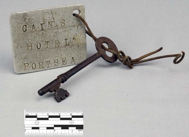
Functional object - Key with Tag
This object features a key with a labelled tag attached to it. It was once the key to the well-known Nepean Hotel. Also known locally as 'The Castle', likely due to its grand size and turret-like tower, the Nepean Hotel was officially established in 1872 by James Sandle Ford (https://poi-australia.com.au/points-of-interest/australia/victoria/portsea/approximate-site-ford-family-nepean-hotel-c-1870-pt-nepean-rd-near-fitzjohns-crt-portsea-mornington-peninsula-vic/). Born in 1811, Ford was only nineteen years old when he was sentenced to seven years transportation for 'Machine Breaking' in 1830. (https://nepeanhistoricalsociety.asn.au/james-sandle-ford/). He arrived in Van Diemen's Land (Tasmania) in 1831 and served five years of his sentence, before being pardoned in 1836. Ford met and married Irish immigrant Hannah Sullivan in 1841 in Sydney. The following year, the couple settled in Point Nepean. Ford is often accredited with the naming of the town of Portsea - after Portsea in Hampshire, UK - and spent a lifetime establishing himself throughout the area. This included: lime burning, dairying, horse judging and breeding, and the cultivation of land and livestock. Ford died in 1890, however his hotel continued to operate for many decades, run by his descendants - including Julia Cain during the first half of the twentieth century (https://trove.nla.gov.au/newspaper/article/65817831) (https://trove.nla.gov.au/newspaper/article/3734533). The hotel was demolished in 1971. This object is significant as it is important in relation to the development and prosperity of the area of Point Nepean. A door key with a rusted surface. One end of the key features a single set of teeth with three notches. Attached to the other end is a rounded handle with a hole through the middle. Looped through the hole is a piece of thin, rusted wire. The wire is looped through both the key and a hole in a white square-shaped tag. Printed on the tag are the words: 'CAIN'S HOTEL PORTSEA'. CAIN'S HOTEL, PORTSEAnepean hotel, cain family, james ford, james sandle ford, portsea hotel -
Lakes Entrance Historical Society
Book, Allard, Peter and Alues, Geoff, Border Tales - Stories from Genoa,Wangarabell, Wroxham.Timbillica, Maramingo, Nungatta, Wingan and Gipsy Point, 2000
A short history of the life and times of residents of Genoa, Victoria, and associated border settlements. Not indexed, but has comprehensive contents list.aboriginals, township, timber industry, transport -
 Lakes Entrance Historical Society
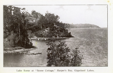
Photograph - Scone Cottage, 1920c
... tourist venue, run by Mrs Westerson. Distant view of Jemmys Point... by Mrs Westerson. Distant view of Jemmys Point. Lakes Entrance ...Copied from a postcardBlack and white photograph of Harpers Bight, Gippsland Lakes. It shows rustic jetty in foreground with boat moored, jetty below zigzag pathway to Cliff Crest Tea Rooms, a popular tourist venue, run by Mrs Westerson. Distant view of Jemmys Point. Lakes Entrance VictoriaLakes Scene at Scone Cottage, Harpers Bay, Gippsland Lakes tearoom, tourism, waterways -
 Lakes Entrance Historical Society
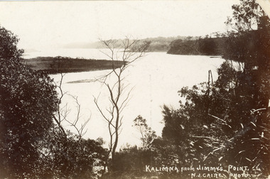
Postcard - Reeves Channel, Caire Nicholas John, 1905c
Also black and white enlargement 16 x 25Black and white postcard of the lake below Jemmys Point, Gippsland Lakes, showing Rigby Island opposite the steep cliffs of Kalimna and Nungurner shores of lakes. Small island, known as the Doughboy of Rigby Island. View taken from Jemmys Point with natural vegetation in foreground. Lakes Entrance VictoriaKalimna from Jimmys Pointislands, waterways, topography, boats and boating -
 Lakes Entrance Historical Society
Photograph - Hopetoun Channel, 1950c
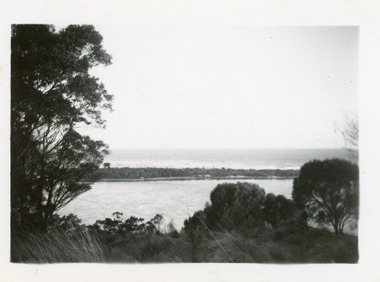
... in foreground Jemmys Point. Lakes Entrance Victoria... showing sand dunes and Hopetoun Channel, Lakes Entrance, Victoria ...Black and white photograph showing sand dunes and Hopetoun Channel, Lakes Entrance, Victoria. Sand dunes near entrance Western Pier, hidden by trees. Schnapper Cottage just visible on shore. Bass Strait beyond dunes, trees and shrubbery in foreground Jemmys Point. Lakes Entrance Victoriaislands, topography, waterways -
 Lakes Entrance Historical Society
Postcard - Gippsland Lakes, Bulmer and Segerberg, 1915c
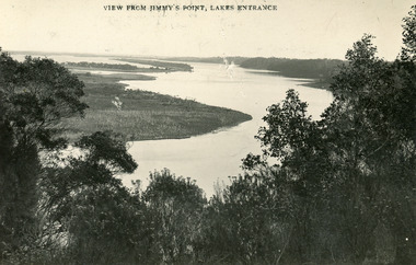
Black and white postcard of the Gippsland lakes, taken from Jemmys Point. It shows Rigby Island, Fraser Island and Flannagan Island, Reeves Channel. Natural vegetation in foreground. Lakes Entrance VictoriaView from Jimmy's Point Lakes Entranceislands, waterways, topography -
 Lakes Entrance Historical Society
Photograph - Reeves River, 1910c
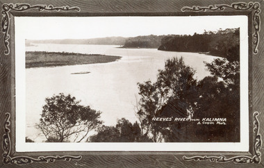
Also another copy print 8 x 13, both printed as though framedBlack and white photograph of Reeves Channel, Gippsland Lakes. It shows Rigby Island opposite the steep cliffs of mainland shore. Small island off Rigby was known as the Doughboy. Taken from Jemmys Point, natural vegetation in foreground. Lakes Entrance VictoriaReeves River from Kalimnaislands, waterways, topography -
 Lakes Entrance Historical Society
Photograph - Nungurner Jetty, 1938
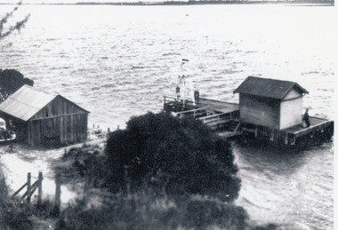
Reprinted from Rev. Alfred Maher's photo album, Anglican Church Archives, Sale, VictoriaBlack and white photograph of Nyerimilang Jetty, Gippsland Lakes. It shows a short jetty with boat landing, navigation light and storage shed on jetty, boatshed on bank. Small motor car beside boat shed. Distant view across lake to eastern point of Flanagan Island, Fraser Island and Rigby Island. Lakes Entrance Victoriajetties, boats and boating, waterways, topography -
 Lakes Entrance Historical Society
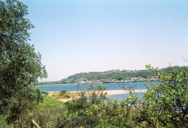
Photograph - Lakes Entrance, Davies, Judy, 2005c
Colour photograph of Jemmys Point, Kalimna Heights, and the Western end of the township, taken from the southern shore of Cunninghame Arm. Small sand spit and natural vegetation in foreground. Lakes Entrance Victoriajetties, waterways, topography, township -
 Lakes Entrance Historical Society
Photograph - S.S. Gippsland, 1920c
Black and white photograph of the steamer Gippsland leaving the Kalimna Jetty Gippsland Lakes Victoria. It shows the steep cliffs of Jemmys Point Bullock Island and entrance in the background. Lakes Entrance VictoriaKalimna Cove and Jetty Gippsland Lakesjetties, topography, ships and shipping -
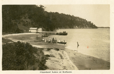 Lakes Entrance Historical Society
Postcard - Kalimna Jetty, 1920c
Personal message on back of postcardBlack and white postcard of Kalimna Jetty. It shows a jetty and landing with sheds, also shows seven people on rustic jetty in middle of photo, four people in boat. Jemmys Point road cutting in background. Lakes Entrance VictoriaGippsland Lakes at Kalimnajetties, waterways, tourism, boats and boating -
 Lakes Entrance Historical Society
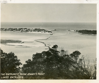
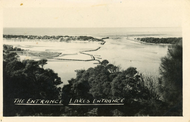
Postcard - The Entrance, 1940c
Originally in a pack of miniature postcards produced for sale to tourists.Black and white small format postcard of the Western end of Bullock Island, Reeves and Entrance Channels, the Entrance and Carpenter Town at the New Works. Taken from Jemmys Point, it shows rock groynes built to channel water flow to the Entrance. Lakes Entrance VictoriaThe Entrance Jemmys Point Lakes Entrance V2 topography, waterways -
 Lakes Entrance Historical Society
Postcard - The Entrance, 1940c
Also one similar images, 7 x 12.5, donated by Pam Cole, Lara VicBlack and white postcard of Bullock Island, and rock groynes, Reeves and Entrance Channels and Carpenter Town at the New Works, taken from Jemmys Point, dense vegetation in foreground. Lakes Entrance VictoriaThe Entrance Lakes Entrance waterways, topography, township -
 Lakes Entrance Historical Society
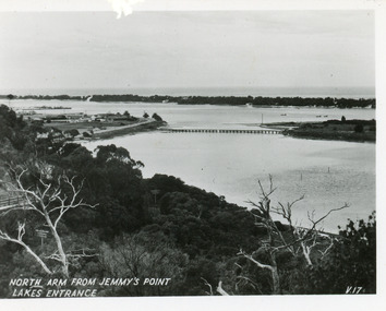
Postcard - North Arm, Valentine Series, 1930c
This is the before paired photograph used in the 150 year Lakes Entrance 1858-2008 display.|The after paired photograph number is 01590.1 Also one 12 x 16 framed photograph used in room display.Black and white small format postcard of North Arm and Cunninghame Arm of Gippsland Lakes, taken from Jemmys Point, Club Hotel at western end of town, bridge to Bullock Island, scrub covered hummocks and Bass Strait in distance. Lakes Entrance VictoriaNorth Arm from Jemmys Point Lakes Entrancebridges, islands, waterways, topography -
 Lakes Entrance Historical Society
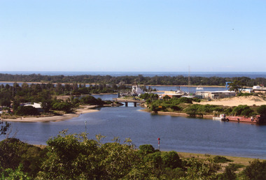
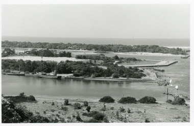
Photograph - North Arm Lakes Entrance, 2008
Date made August 2008Colour photograph of North Arm and Cunninghame Arm, taken from Jemmys Point, shows small bridge to Bullock Island, the Seamec educational facility in the background. Lakes Entrance Victoriabridges, fishing industry, islands, waterways, topography -
 Lakes Entrance Historical Society
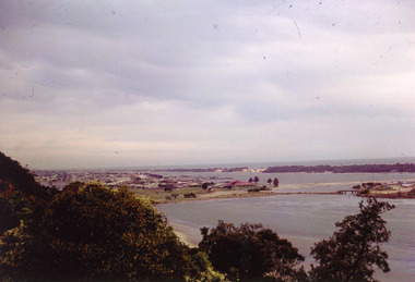
Photograph - Lakes Entrance, Nelson Joan, 1975c
Colour photograph of the township, taken from Jemmys Point. It shows the causeway and raised bridge to Bullock Island, scrub covered sand hummocks and Bass Strait in distance. Lakes Entrance Victoria waterways, topography, township -
 Lakes Entrance Historical Society
Photograph - Bullock Island, 1990c
Black and white photograph of the entrance. It shows two fishing boats moored in North Arm, western end of Bullock Island with Fishermens Co-op building, and area below Jemmys Point, both formed during dredging operations over many years. Lakes Entrance Victoria waterfront, islands -
 Lakes Entrance Historical Society
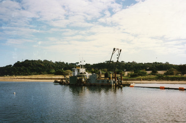
Photograph - Dredging, 1998
Color photograph of Bullock Island. It shows the dredge Sandpiper working in Cunninghame Arm on the southern shore of Bullock Island. Dredged sand in background on island from previous dredging operations, Kalimna Heights and Jemmys Point in the background. Lakes Entrance Victoriaislands, waterways, public works, dredging -
 Lakes Entrance Historical Society
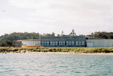
Photograph - TAFE building, 2005
Date made September 2005Colour photograph of the RMIT TAFE Educational Facility on Bullock Island, taken from Cunninghame Arm. In the background is the navigation lights on Jemmys Point and residence on Kalimna Heights. Lakes Entrance Victoriaislands, education