Showing 1028 items matching "water river"
-
 Merbein District Historical Society
Administrative Record, Ledger, Irrigation Rate Book- Yelta, 1928-1929
... Blocks State Rivers and Water Supply Commission Yelta Ledger ...blocks, state rivers and water supply commission, yelta -
Merbein District Historical Society
Administrative Record, Ledger, Irrigation Rate Book- Merbein, 1912-1913
... Blocks State Rivers and Water Supply Commission Ledger ...blocks, state rivers and water supply commission -
Merbein District Historical Society
Administrative Record, Ledger, Irrigation Rate Book- Merbein, 1913-1914
... Blocks State Rivers and Water Supply Commission Ledger ...blocks, state rivers and water supply commission -
Merbein District Historical Society
Administrative Record, Ledger, Irrigation Rate Book - Merbein, 1921-1922
... Rivers & Water Supply Commission Sunraysia Rural Water Authority ...state rivers & water supply commission, sunraysia rural water authority, water allocations - merbein, irrigators -
Merbein District Historical Society
Administrative Record, Ledger, Irrigation Rate Book- Merbein, 1915-1916
... Blocks State Rivers and Water Supply Commission Ledger ...blocks, state rivers and water supply commission -
Merbein District Historical Society
Administrative Record, Ledger, Irrigation Rate Book - Merbein (Parish), 1921-1929
... Township State Rivers and Water Supply Commission Ledger ...township, state rivers and water supply commission -
Merbein District Historical Society
Administrative Record, Ledger, Irrigation Rate Book - Merbein (Urban), 1927-1930
... Township State Rivers and Water Supply Commission Ledger ...township, state rivers and water supply commission -
Merbein District Historical Society
Administrative Record, Ledger, Irrigation Rate Book - Merbein (Parish), 1917-1920
... Township State Rivers and Water Supply Commission Ledger ...township, state rivers and water supply commission -
Merbein District Historical Society
Administrative Record, Ledger, Irrigation Rate Book - Merbein (Parish), 1935-1938
... Township State Rivers and Water Supply Commission Ledger ...township, state rivers and water supply commission -
Merbein District Historical Society
Administrative Record, Ledger, Irrigation Rate Book - Yelta, 1922-1923
... Rivers & Water Supply Commission Sunraysia Rural Water Authority ...state rivers & water supply commission, sunraysia rural water authority, water allocations - yelta, irrigators - yelta -
Merbein District Historical Society
Administrative Record, Ledger, Irrigation Rate Book - Merbein, 1922-1923
... Rivers & Water Supply Commission Sunraysia Rural Water Authority ...state rivers & water supply commission, sunraysia rural water authority, water allocations - merbein, irrigators - merbein -
Merbein District Historical Society
Administrative Record, Ledger, Irrigation Rate Book - Merbein, 1923-1924
... Rivers & Water Supply Commission Sunraysia Rural Water Authority ...state rivers & water supply commission, sunraysia rural water authority, water allocations - merbein, irrigators - merbein -
Merbein District Historical Society
Administrative Record, Ledger, Irrigation Rate Book - Merbein, 1924-1925
... Rivers & Water Supply Commission Sunraysia Rural Water Authority ...state rivers & water supply commission, sunraysia rural water authority, water allocations - merbein, irrigators - merbein -
Merbein District Historical Society
Administrative Record, Ledger, Irrigation Rate Book - Merbein, 1925-1926
... Rivers & Water Supply Commission Sunraysia Rural Water Authority ...state rivers & water supply commission, sunraysia rural water authority, water allocations - merbein, irrigators - merbein -
Merbein District Historical Society
Administrative Record, Ledger, Irrigation Rate Book - Merbein, 1926-1927
... Rivers & Water Supply Commission Sunraysia Rural Water Authority ...state rivers & water supply commission, sunraysia rural water authority, water allocations - merbein, irrigators - merbein -
Merbein District Historical Society
Administrative Record, Ledger, Irrigation Rate Book - Merbein, 1927-1928
... Rivers & Water Supply Commission Sunraysia Rural Water Authority ...state rivers & water supply commission, sunraysia rural water authority, water allocations - merbein, irrigators-merbein -
Merbein District Historical Society
Administrative Record, Ledger, Irrigation Rate Book - Merbein, 1928-1929
... Rivers & Water Supply Commission Sunraysia Rural Water Authority ...state rivers & water supply commission, sunraysia rural water authority, water allocations - merbein, irrigators - merbein -
Merbein District Historical Society
Administrative Record, Ledger, Irrigation Rate Book - Merbein, 1929-1930
... Rivers & Water Supply Commission Sunraysia Rural Water Authority ...state rivers & water supply commission, sunraysia rural water authority, water allocations - merbein, irrigators - merbein -
Merbein District Historical Society
Slide, Murray River view from Pump Hill, unknown
... Hill Merbein Pumping Station State Rivers & Water Supply ...pump hill, merbein pumping station, state rivers & water supply commission -
 Glenelg Shire Council Cultural Collection
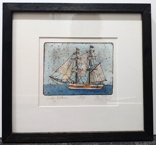
Artwork, other, BRIGIT THOMAS, Lady Nelson, c. 2015
... of the Royal Navy to allow surveying in rivers and shallow water ways... of the Royal Navy to allow surveying in rivers and shallow water ways ...From - theladynelson.org.au T The original Lady Nelson was built at Deptford, in England, in 1799, for service to the Transport Office on the River Thames. She was designed with sliding keels (centre boards), a device invented by Captain John Schank of the Royal Navy to allow surveying in rivers and shallow water ways. On completion she was selected for exploration services in the Colony of New South Wales and sailed for Port Jackson on 18 March 1800 under the command of Lieutenant James Grant. A brig of 60 tons, she carried a crew comprising the commander, two mates and twelve seaman. As she left the River Thames sailors on nearby ships ridiculed her because of her size and shape, calling her, as she sailed past, 'His Majesty's Tinderbox'. At Portsmouth on the 9th February 1800 she was fitted with four brass carriage guns, three to four pounders, in addition to the two guns already on board. Because of the heavy load she was carrying she was very low in the water, having only two feet nine inches freeboard amidships. The ship finally left Portsmouth on 17th March 1800 as part of an East Indian Convoy. From 1800 to 1825 the Lady Nelson operated around the Australian Coast and fulfilled a variety of roles including exploration, surveying, forming settlements, shifting goods and people around the colonies and capturing pirates. She played pivotal roles in the European settlement of Hobart, Northern Tasmania, Melbourne, Newcastle, Port Macquarie and Northern Territory. Those onboard charted much of Bass Strait, Port Philip, Newcastle, Port Macquarie and (with the Investigator) the coasts of northern New South Wales and southern Queensland. She also has links to other locations around the East Coast such as Trial Bay in NSW and the Mt Gambier area of SA. After 25 years of service while trading on the island of Baba the Lady Nelson was overrun by the islanders, the crew was killed and the ship stripped and later burnt and sunk. A replica of the Lady Nelson was built in the 1980s.Image of a tall ship in sail. The ship is flying both the Aboriginal flag and the Australian Flag. It sails on a calm sea. There are figures on the deck - four in total. The image is mounted on cream board and framed in dark timber. Etching, hand coloured,.Front: 'Lady Nelson A/P BT' - hand written, pencil in between etching and mount Back: Artist's business card glued to back of etching, lower left hand corner:ady nelson, femal artists, female artist, women -
Merbein District Historical Society
Document, Water Talk Merbein SRWSC, Sept.1961
... Rivers & Water Supply Commission R.T.J. Webber L.C. Anders Water ...state rivers & water supply commission, r.t.j. webber, l.c. anders -
 Bendigo Historical Society Inc.
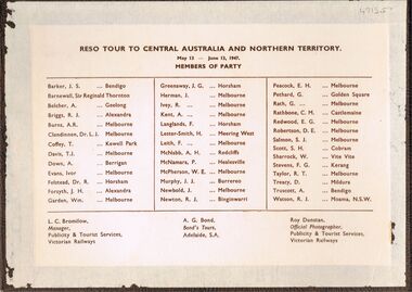
Photograph - PETHARD COLLECTION: PHOTOGRAPH RESO TOUR
George Pethard Collection including references to Taraxale Brewing Company Pty brown covered 29x19mm photographic album bound with gold string / 52 black and white Photographs of Reso tour to central Australia and Northern Territory / includes Aboriginal camps , camel trains / landscapes , war cemetery at Adelaide River / May 13- June 13 1947 / the 40 members of the party are also named includes: George Pethard / Aboriginal camp , Jay Creek consisting of makeshift tents / crowd playing 'Two Up ' Photo of the ship 'Meggs' at Darwin / Manton Dam - Darwin's water supply photo. Reso Tour to Central Australia and Northern Territory.Roy Dunstan Publicity and Tourist services Victoria Railwaysphotograph, person, male, george pethard / taraxale brewing company pty ltd / aboriginal camps / camel trains / war cemetary at adelaide river photo of the ship 'meggs' at darwin / manton dam - darwin's water supply photo -
 Glenelg Shire Council Cultural Collection
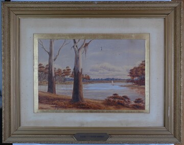
Painting, Scene on the River Murray, n.d
Art Collection Previously located in History HouseThe painting depicts a body of water with two large trees in the foreground. The two trees are situated on the left side of the riverbank which extends across the foreground of the work. The trees extend beyond the borders of the work with only a few branches visible at the top of the work. To the right of the trees, on the surfaceof the water, is a boat with a large white sail. The river bed continues on the left and right sides of the work and is covered with brown trees. The background features a distant view of the riverbank covered in blue trees. The work has a gilded ornate frame with cardboard and gilded mount and glass.Front: A.S. Murray plaque attached to frame: SCENE on the RIVER MURRAY Back: W. HAMER __________Street, Ballarat -
 Glenelg Shire Council Cultural Collection
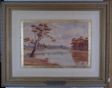
Painting, A.S. Murray, Scene on the River Murray, n.d
Art collection Previously located in History HouseThe painting depicts a large body of water surrounded by tree-covered riverbank. Depicted in shades of blue and grey, the water features patches of brown and blue which illustrate the reflections of riverbank trees. In the foreground to the left of the water is a large tree which extends up to cover the top left skyline of the work. Featured in the background is a dense patch of trees completed in shades of blue. To the right of the water is a dense patch of trees completed in shades of brown and black. These trees reach into a purple and blue cloud-filled sky. The work has a gilded ornate frame with cardboard and gold mount and exposed canvas.Front: A.S. Murray Plaque attached to frame: SCENE on the RIVER MURRAY Back: (no inscriptions) -
 Federation University Historical Collection
Book, Geological Gossip or Stray Chapters on Earth and Ocean, 1860, 1860
... geology water rivers the atlantic great deep africa ...Brown hard covered book. Chapter 16 is on gold deposits and discusses the discovery of gold in California and Australia.Brown hard covered book geology, water, rivers, the atlantic, great deep, africa, australian interior, eyre's expedition, murray river, darling river, earthqaukes, leichardt, moreton bay, volcanos, darwin's theory, evolution, egyptian race, human remains in caverns and gravel, rocks, metamorphism, iron ores, coal, coal fields, gold deposits, california, water-glass, artificial stone, porous stones, cements -
Lakes Entrance Historical Society
Book, North East Regional Tourist Authority, North East Victoria, 1980
A brief record of the region from the Murray River in the north to the Dargo High Plains in the south, from Yarrawonga and Wangaratta in the west to the Indi River in the east. Illustrated with coloured photographs.tourism, mines and mining, settlers, water supply -
Lakes Entrance Historical Society
Book, State Rivers and Water Supply Commission, The State of the Rivers Victoria Australia, 1983
... of the Rivers Victoria Australia Book State Rivers and Water Supply ...The third (1983) report by the Standing Consultative Committee on River Improvement, giving an overall review of the state of the rivers of Victoria and the Murray. The subject is covered from the catchment to usage, pollution and drainage. Includes caswaterways, water supply, water pollution -
 Charlton Golden Grains Museum Inc
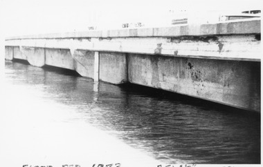
Photograph, Charlton Tribune, B/W Photograph of 1973 Flooded Avoca River, February 1973
1973 Flooded Avoca River in Charlton Victoria at the Paterson Bridge. Water Level 25ft 1 1/2 inches - all local waterunframed 1973 Flooded Avoca River in Charlton Victoria at the Paterson Bridge. Water Level 25ft 1 1/2 inches - all local waterflood charlton victoria, james paterson bridge, local water -
 Ringwood and District Historical Society
Photograph, The Lewis Findlay East Residence, Bedford Rd, Ringwood. 1901
... of the State Rivers and Water Supply Commission in 1936, and received... of the State Rivers and Water Supply Commission in 1936, and received ...Black and white photograph of weatherboard house surrounded by a picket fence. (2 copies- 1 large, 1 small). Typed notes detailing history of cottage.Typed notes contain the following: "Cottage and Lot 15, Sec.C, Township of Ringwood - comprising 1 acre - were acquired from the Crown by John Price on 17th July, 1888, for £30. Subsequently, a 4-roomed weatherboard cottage was built on Lot 15. On 21st May, 1901, the two allotments and the house were transferred to Lewis Findlay East for £85, and on 13th March, 1942, were sold to R. Barr and L. Beaumont for £650 with two additional rooms and some other improvements including reticulated water supply. Lewis Findlay EAST and his family occupied the cottage until 1910. It is believed that before the cottage was purchased by East, it was occupied for a period by McCubbin the artist. Lewis Findlay East was a member of an Australian Rifle Team which went to Bisley, England, in 1901, and won the Kalapore Cup. He was an officer of the Department of Customs, and later became Secretary of the Commonwealth Marine Branch, receiving the I.S.O. His son, Lewis Ronald East, became Chairman of the State Rivers and Water Supply Commission in 1936, and received C.B.E.". -
Lakes Entrance Historical Society
Book, Synan Peter, Highways of Water- How shipping on the Lakes shaped Gippsland, 1989
A history of the Gippsland Lakes Victoria as a transport system for trade with in the lakes and river systems, and coastal and interstate tradeships and shipping, land settlement, waterways