Showing 1139 items
matching waterway
-
 Lakes Entrance Regional Historical Society (operating as Lakes Entrance History Centre & Museum)
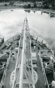
Photograph - April Hamer, Lakes Post Newspaper, 1999
Black and white photograph of forward deck of the sand dredge April Hamer. In the background is the tourist information centre top right hand corner. Lakes Entrance Victoriawaterways, dredging, township -
 Lakes Entrance Regional Historical Society (operating as Lakes Entrance History Centre & Museum)
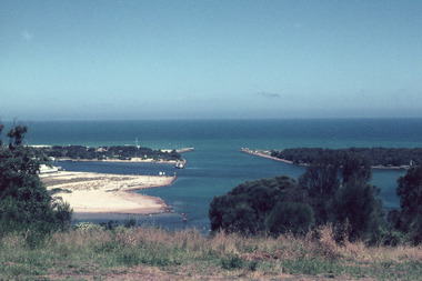
Photograph - Bullock Island, Scarce, Keith, 1975 c
Second photograph showing part of Bullock Island and the entrance.Colour photograph of Bullock Island, after establishment of Pecks Factory and Fishermans Co-op, shows marram grass plantings to stabilise dumped sand. Rough surf breaking on offshore bar. Lakes Entrance Victoriawaterways, islands -
 Lakes Entrance Regional Historical Society (operating as Lakes Entrance History Centre & Museum)
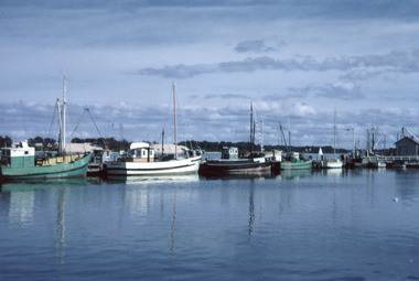
Photograph - Kiangah, Scarce, Keith, 1975 c
Second photograph closer view. 'Kiangah' built of spotted gum by Bulls Shipyard, Metung for Harry RoseColour photograph of fishing boats at Eastern Wharf. Kiangah in centre of image. Lakes Entrance Victoriaislands, ocean, fishing industry, waterways -
 Lakes Entrance Regional Historical Society (operating as Lakes Entrance History Centre & Museum)
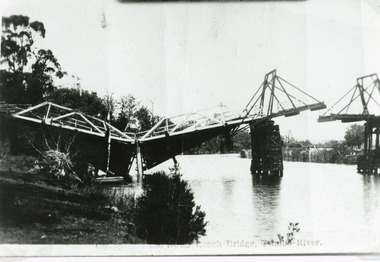
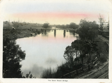
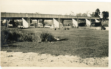
Photograph - Bridges, Bulmer H D, 1925
Swan Reach Bridge collapsed 10.00 am 16 November 1925Black and white photograph showing collapsed bridge over the Tambo River, bridge collapsed at eastern end. Photo looking downstream. Two people on landing on far right bank behind right hand bridge pylon. Thick vegetation on bank. Swan Reach VictoriaSwan Reach Bridge on the Tambo Riverwaterways, boats and boating, disasters -
 Lakes Entrance Regional Historical Society (operating as Lakes Entrance History Centre & Museum)
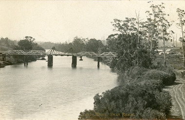
Postcard - Bridges, 1906
Postcard dated 3 December 1913, Bairnsdale, addressed to Mrs Brewer, Metung, Gippsland.Black and white postcard showing wooden lift bridge over Tambo River, Swan Reach, Victoria. Old punt visible at left bank under bank, thick vegetation on right bank, houses in right background above Metung Road.Tambo River, Swan Reachbridges, waterways -
 Lakes Entrance Regional Historical Society (operating as Lakes Entrance History Centre & Museum)
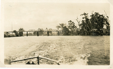
Photograph - Bridges, 1925
Photo taken same year Swan Reach bridge collapsed 16 November 1925Black and white photograph of the lifting bridge over the Tambo River taken from the stern of a boat. A tourist launch under the bridge in distance. Swan Reach Victoriabridges, waterways -
 Lakes Entrance Regional Historical Society (operating as Lakes Entrance History Centre & Museum)
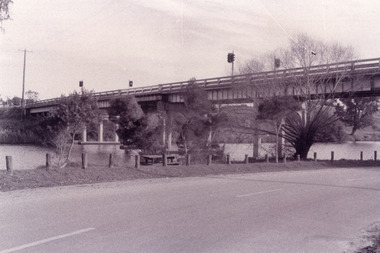
Photograph - Bridges, Fish Marie, 1995
Black and white photograph showing view of the Swan Reach bridge over the Tambo River. Traffic lights on bridge to control traffic and reduce weight. Swan Reach Victoriabridges, waterways, roads and streets -
 Lakes Entrance Regional Historical Society (operating as Lakes Entrance History Centre & Museum)
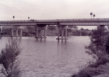
Photograph - Bridges, Fish Marie, 1995
Black and white photograph showing view of the Swan Reach bridge over the Tambo River. Traffic lights on bridge to control traffic and reduce weight. Swan Reach Victoriabridges, waterways, roads and streets -
 Lakes Entrance Regional Historical Society (operating as Lakes Entrance History Centre & Museum)
Photograph - Bridges, Fish Marie, 1995
Black and white photograph showing view of the Swan Reach bridge over the Tambo River. Traffic lights on bridge to control traffic and reduce weight. Swan Reach Victoriabridges, waterways -
 Lakes Entrance Regional Historical Society (operating as Lakes Entrance History Centre & Museum)
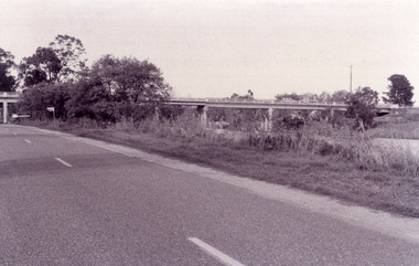
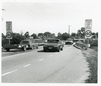
Photograph, 1994
Date made March 1994Black and white photograph showing traffic and restriction signs on Swan Reach Bridge, over theTambo River prior to funding being made available for strengthening and widening. Swan Reach Victoriabridges, waterways, vehicles -
 Lakes Entrance Regional Historical Society (operating as Lakes Entrance History Centre & Museum)
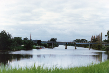
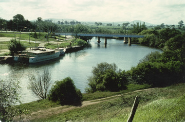
Photograph - Bridges, 1990
Colour photograph showing view of the Tambo River at Swan Reach looking upstream. Boats at jetty on left, vegetation on each bank, poplar trees on right. Swan Reach Victoriabridges, waterways -
 Lakes Entrance Regional Historical Society (operating as Lakes Entrance History Centre & Museum)
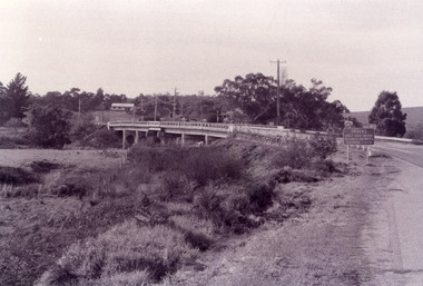
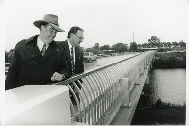
Photograph - Bridges, Lakes Post Newspaper, 1995
The first concrete bridge built over Tambo River at Swan Reach, in 1932 was never officially opened, so the opening of the refurbished bridge on 19 December 1995 was declared 'The Official Opening'. Photo taken at the Official Opening 19 December 1995Black and white photograph showing David Treasure, MLA, and Norm Butler of VicRoads, on the strengthened and widened bridge, over the Tambo River at Swan Reach, Victoria.bridges, waterways, officials -
 Lakes Entrance Regional Historical Society (operating as Lakes Entrance History Centre & Museum)
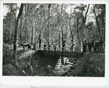
Photograph - Bridges, 1896
Original photo 12.5 x 17 cm on grey card 20 x 24.5 cmBlack and white photograph showing Boggy Creek Bridge,seven men on bridge, one horse at left end of bridge and two horses at right hand end of bridge. Bridge rests on log supports under. No water in creek. Thick bush around area. East Gippsland VictoriaBoggy Creek Bridge - Vic (Written on back)bridges, waterways, vegetation -
 Lakes Entrance Regional Historical Society (operating as Lakes Entrance History Centre & Museum)
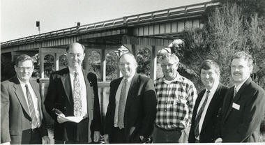
Photograph - Bridges, 1994
Image appeared in Lakes Post newspaper 18 May 1994Black and white photograph of six men standing beside the Tambo River, with the Swan Reach bridge in the background, meeting to stress the poor condition of the bridge and the urgent need for the promised funding. Swan Reach Victoriabridges, waterways, public events -
 Lakes Entrance Regional Historical Society (operating as Lakes Entrance History Centre & Museum)
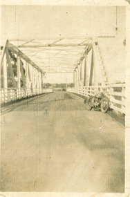
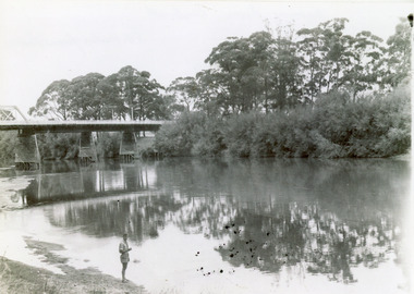
Photograph - Bridges, 1940
After 1934 flood damage to second bridge, centre pile was replaced by a truss girder, this survived until 1971 floodBlack and white photograph showing second Orbost Bridge over the Snowy River, wooden planks, railing and overhead support. Motor bike leaning on railing at near end of bridge. Orbost, Victoria.bridges, waterways -
 Lakes Entrance Regional Historical Society (operating as Lakes Entrance History Centre & Museum)
Photograph - Bridges, 1947
Date made February 1947Black and white photograph showing part of the road bridge over there Snowy River, river level low, man in shorts standing at edge of river. Orbost, Victoria.bridges, waterways, recreation -
 Lakes Entrance Regional Historical Society (operating as Lakes Entrance History Centre & Museum)
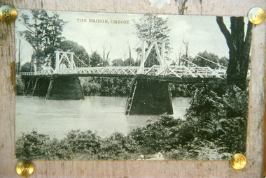
Photograph - Bridges, 1920
First bridge over the Snowy River at Orbost built 1891Black and white photographic print showing early first bridge across Snowy River thick vegetation along river banks. Orbost Victoriabridges, waterways -
 Lakes Entrance Regional Historical Society (operating as Lakes Entrance History Centre & Museum)
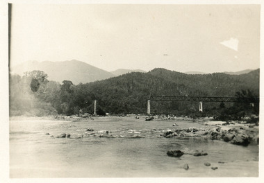
Photograph - Bridges
Black and white photograph showing partially built McKillops Bridge on Snowy River, East Gippsland, Victoria.Cantilever new bridge over Snowy River at McKillops Crossing, 45 feet above recorded flood, washed away before officially opened, decking, etc, down stream more than a mile. (on back)bridges, waterways, topography, construction -
 Lakes Entrance Regional Historical Society (operating as Lakes Entrance History Centre & Museum)
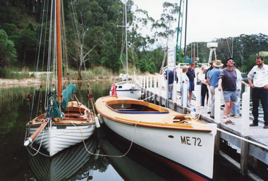
Photograph - ME72 Maranui, 1996
Date made 19 October 1996Colour photograph showing restored and reberthed launch Maranui at Metung Hot Pools Jetty in Chinaman's Creek, registered vessel no. ME72, white clinker built sailing boat on left and white trailer sailer at rear of Maranui. Visitors on jetty. Metung Victoria waterways, boats and boating, tourism -
 Lakes Entrance Regional Historical Society (operating as Lakes Entrance History Centre & Museum)
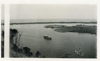
Photograph - S.S. Gippsland, 1920c
Black and white photograph showing S S Gippsland in Reeves Channel, sailing west towards Metung, taken from Jemmys Point and showing Snake Island and end of Rigby Island and hummocks on far side of Hopetoun Channel in background. Lakes Entrance Victoria waterways, ships and shipping -
 Lakes Entrance Regional Historical Society (operating as Lakes Entrance History Centre & Museum)
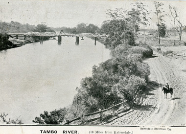
Postcard - Bridges, 1906
First timber road bridge over the Tambo River at Swan Reach officially opened 20 December 1905, after which punt was removed to BairnsdaleBlack and white postcard of the lifting bridge over the Tambo River at Swan Reach, Victoria. Man on horse standing on dirt road to Metung beside the river. Punt previously used to cross river visible against western bank of river.Tambo River (16 miles from Bairnsdale)bridges, waterways -
 Lakes Entrance Regional Historical Society (operating as Lakes Entrance History Centre & Museum)
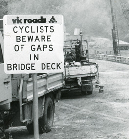
Photograph, Lakes Post Newspaper, 1991
Date made January 1991Black and white photograph taken when work commenced on the construction of the new concrete bridge on the Princes Highway, Toorloo Arm, near Lakes Entrance. Road works in distance, crane beside present bridge, Vicroads warning sign to cyclists in foreground. Toorloo Arm Victoriabridges, waterways -
 Lakes Entrance Regional Historical Society (operating as Lakes Entrance History Centre & Museum)
Postcard - Bridges, Bulmer, H D, 1915
Colour tinted large format postcard showing lifting bridge over the Tambo River, at Swan Reach, Victoria. Bridge is closed to allow road traffic through. Rough gravel road to Metung on right. Landing on left near bridge. Vegetation on river bank right. Houses in distance on both sides of river.The Swan Reach Bridgeboats and boating, bridges, waterways -
 Lakes Entrance Regional Historical Society (operating as Lakes Entrance History Centre & Museum)
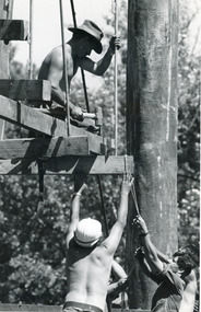
Photograph - Bridges, Bairnsdale Advertiser, 1990
Also a second photograph showing men constructing the footbridge.Black and white photograph showing Army Reservists building the suspension footbridge over the backwater near Bairnsdale, Victoriaboats and boating, bridges, waterways, construction -
 Lakes Entrance Regional Historical Society (operating as Lakes Entrance History Centre & Museum)
Photograph - Bridges, 1935
Also second photograph of swing bridge closed with lady in the foreground 6 x 8.5Black and white photograph showing closed swing bridge over Latrobe River, corner of jetty lower right hand corner. Sale, Victoria.bridges, waterways, jetties -
 Lakes Entrance Regional Historical Society (operating as Lakes Entrance History Centre & Museum)
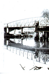
Photograph - Bridges, Jemmeson, Edie, 1925
Also photograph of the bridge closed 7 x 11.5Black and white photograph of the swing bridge open over the Latrobe River at Longford, Victoria.bridges, waterways -
 Lakes Entrance Regional Historical Society (operating as Lakes Entrance History Centre & Museum)
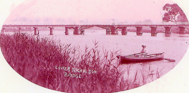
Photograph - Bridges, 1900
Opened March 1889, centre lifting span unsuccessful so shipping trade up Nicholson River effectivly terminatedPink toned scanned photograph of the first bridge across the Nicholson River. Shows a timber bridge with centre designed as a drawbridge. Woman in rowing boat in foreground. Nicholson VictoriaNicholson River Bridgebridges, waterways -
 Lakes Entrance Regional Historical Society (operating as Lakes Entrance History Centre & Museum)
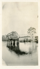
Photograph - Bridges, 1925
Black and white photograph showing rail bridge across Mitchell River. Photograph shows side of rail bridge on south side, trees top right hand corner. Left hand side of photograph shows the road bridge. Bairnsdale, Victoriabridges, waterways -
 Lakes Entrance Regional Historical Society (operating as Lakes Entrance History Centre & Museum)
Photograph - Bridges, 1950
Colour photograph of unfinished Cataraman Llinase on Mitchell River, at Bairnsdale Wharf, railway bridge and highway bridge over the river, road to Paynesville under bridge, wharf on left, Mt Taylor and Mt Lookout in background. Bairnsdale Victoriabridges, waterways, boats and boating