Showing 1137 items
matching waterways
-
 Lakes Entrance Regional Historical Society (operating as Lakes Entrance History Centre & Museum)
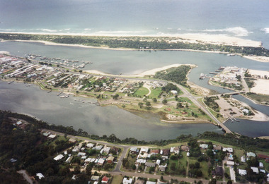
Photograph, 1997c
... Waterways ...Colour print of aerial view looking south of western side of township. Shows housing on Kalimna Hill, North Arm, part of Bullock Island, Cunninghame Arm, the outer barrier and east pier of man made entrance. Lakes Entrance Victoriawaterways, islands, dredging, accommodation -
 Lakes Entrance Regional Historical Society (operating as Lakes Entrance History Centre & Museum)
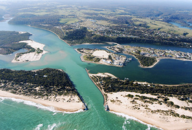
Photograph, 2000
... Waterways ...Colour photograph of aerial view of the entrance at Lakes Entrance, shows part of Rigby Island, Bullock Island, North Arm, Cunninghame Arm and buildup of sand on ocean shores of sand hummocks. Lakes Entrance Victoriahouses, ocean, navigation, waterways -
 Lakes Entrance Regional Historical Society (operating as Lakes Entrance History Centre & Museum)
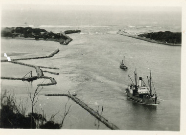
Photograph, 1930 c
... Waterways ...Also black and white copy 8 x 13Small format black and white photograph of S.S. Tambar heading inbound towards Nungurner. Another smaller vessel behind, rock groynes visible for formation of Bullock Island. Lakes Entrance Victoriaships and shipping, jetties, waterways, boardwalk -
 Lakes Entrance Regional Historical Society (operating as Lakes Entrance History Centre & Museum)
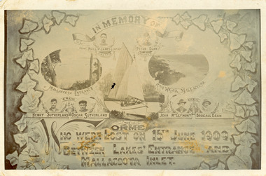
Postcard, 1909c
... Waterways ...Also enlargement 17 x 25.5 cmBlack and white postcard in memory of six crew of fishing boat Orme lost on 15 June 1909 between Lakes Entrance and Mallacoota. Compilation shows images of six men and the Orme surrounded by ivy leaves. Background behind sails has been painted. Lakes Entrance VictoriaIn memory of crew of the 'Orme' who were lost on 15 June 1909 between Lakes Entrance and Mallacoota Inlet.ships and shipping, shipwrecks, waterways, jetties -
 Lakes Entrance Regional Historical Society (operating as Lakes Entrance History Centre & Museum)
Photograph, 1997
... Waterways ...County Antrim was wrecked off coast opposite Metung Victoria January 1897Small format colour photograph of a painting of the SS Riverina which was wrecked off the coast, and the painting is at the Hotel in Cann River, Victoriabuildings, fences, waterways, ships and shipping -
 Lakes Entrance Regional Historical Society (operating as Lakes Entrance History Centre & Museum)
Photograph, 1940c
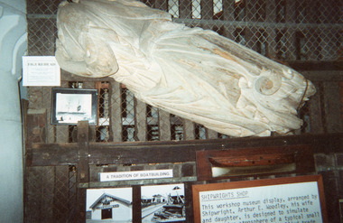
... Waterways ...County Antrim was wrecked off coast opposite Metung Victoria 12 January 1897Black and white photograph showing the figurehead from the County Antrim wrecked off coast, shows wooden figurehead in garden of Kalimna Hotel, where it had been placed as a garden feature soon after the wreck was abandoned. Lakes Entrance Victoriaships and shipping, shipwrecks, ocean, waterways -
 Lakes Entrance Regional Historical Society (operating as Lakes Entrance History Centre & Museum)
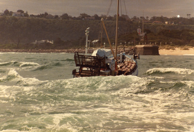
Photograph, 1981
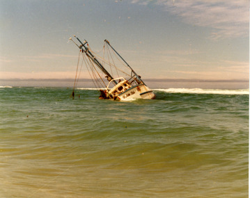
... Waterways ...Date made 13 August 1981Colour photograph of the fishing boat St John Star aground between breakers and shoreline, 20 km east of Lakes Tyers, near Lakes Entrance, Victoria.fishing industry, ships and shipping, waterways, coast -
 Lakes Entrance Regional Historical Society (operating as Lakes Entrance History Centre & Museum)
Photograph, 1980c
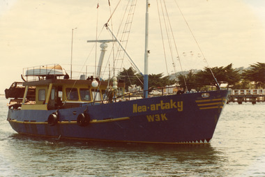
... Waterways ...A 'Bay' boat owner Michael Walker?Colour photograph of scallop fishing boat Neoartaky in Cunninghame Arm, Carnival Ferris wheel in background and memorial cypress trees along Esplanade. Lakes Entrance Victoriafishing industry, celebrations, ships and shipping, waterways -
 Lakes Entrance Regional Historical Society (operating as Lakes Entrance History Centre & Museum)
Photograph, 1980c
... Waterways ...May be 'Lady Jane'Colour photograph of an unidentified scallop fishing boat approaching the entrance channel after crossing the bar. Boat has bags of scallops stacked neatly on deck. Photograph taken from boat following. Lakes Entrance Victoriafishing industry, ships and shipping, waterways, ocean -
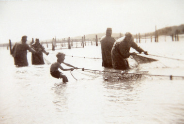
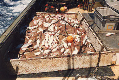
 Lakes Entrance Regional Historical Society (operating as Lakes Entrance History Centre & Museum)
Photograph, 1947 c
... Waterways ...Black and white photograph of four fishermen handling a large net full of fish at the fish pens in the lake inside the western side of the entrance. Two other men on the jetty watching activity, Kalimna Hill in the distance. Lakes Entrance Victoriafishing industry, waterways, fences, animals -
Lakes Entrance Regional Historical Society (operating as Lakes Entrance History Centre & Museum)
Photograph
... Waterways ...Black and white photograph showing fishermen at fish pens. Shows ten men on beach beside fence, 2 or 3 large sharks on beach, spaniel dog on beach. Lakes Entrance Victoriafishing industry, boats and boating, fish, waterways -
 Lakes Entrance Regional Historical Society (operating as Lakes Entrance History Centre & Museum)
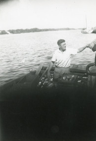
Photograph, 1952 c
... Waterways ...Fish transported to Melbourne market by truckBlack and white photograph of fisherman Jack Allen in rowing boat The Killer boxing fish for icing at Harbecks Jetty, Eastern Wharf. Lakes Entrance Victoria.fishing industry, boats and boating, fish, waterways -
 Lakes Entrance Regional Historical Society (operating as Lakes Entrance History Centre & Museum)
Photograph, 1940 c
... Waterways ...Black and white photograph of fishing boat half full of fish being rowed away from unseen jetty, head and shoulders of young boy on right of image. Lakes Entrance Victoriafishing industry, boats and boating, fish, waterways -
 Lakes Entrance Regional Historical Society (operating as Lakes Entrance History Centre & Museum)
Photograph, 1945 c
... Waterways ...Black and white photograph of a small motor boat towing a fishing boat containing four men hauling a fishnet full of fish in the entrance channel, Lakes Entrance, Victoria.Bringing full fishnets into fishpens (on reverse of original)fishing industry, boats and boating, fish, waterways -
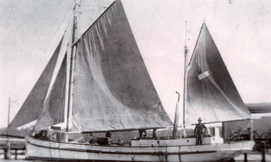 Lakes Entrance Regional Historical Society (operating as Lakes Entrance History Centre & Museum)
Photograph, 1935 c
... Waterways ...Black and white photograph of the fishing ketch Topsy with all sails up, jetty in background, at Lakes Entrance, Victoria.fishing industry, fish, occupation, waterways -
 Lakes Entrance Regional Historical Society (operating as Lakes Entrance History Centre & Museum)
Photograph
... Waterways ...Black and white photograph of fishermen working at the fish pens, showing four men and boy hauling full nets into pens. Lakes Entrance Victoriafishing industry, boats and boating, fish, waterways -
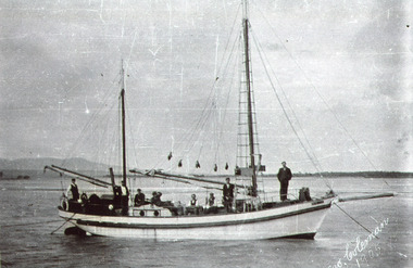 Lakes Entrance Regional Historical Society (operating as Lakes Entrance History Centre & Museum)
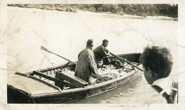
Photograph, 1905 c
... Waterways ...Note in album from Reg Schulz. Ketch 'Crescent' built at Eden NSW about 1905. After a long lay up she was bought by David Coote, Lakes Entrance, about 1925.Black and white photograph showing ketch Crescent at Mallacoota Inlet. Howe Range in background. Nine men onboard. Mallacoota VictoriaGeo. Coleman 1905fishing industry, celebrations, ships and shipping, waterways -
 Lakes Entrance Regional Historical Society (operating as Lakes Entrance History Centre & Museum)
Photograph, Hammarstrom Ian, 1987 c
... Waterways ...Colour photograph of the fishing boat Sylvia which has just left Cunninghame Arm and is heading into the entrance channel on way to fishing grounds off Lakes Entrance, Victoria.ships and shipping, islands, fishing industry, waterways -
 Lakes Entrance Regional Historical Society (operating as Lakes Entrance History Centre & Museum)
Photograph, 1986 c
... Waterways ...Also one other showing a six ton shot in net beside Tarpeena at sea.Colour photograph of the fish catch by the fishing boat Tarpeena showing a small catch on deck. Lakes Entrance Victoriaislands, fishing industry, waterways, houses -
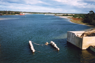
 Lakes Entrance Regional Historical Society (operating as Lakes Entrance History Centre & Museum)
Photograph, Holding M, 2000
... Waterways ...Also two other photographs similar views.|Also one showing old bridge onlyColour photograph showing the building of the new North Arm bridge, old North Arm bridge in background, taken from tourist ferry Mulloway, returning to jetty in North Arm. Lakes Entrance Victoriabridges, waterways, demolition, machinery -
 Lakes Entrance Regional Historical Society (operating as Lakes Entrance History Centre & Museum)
Photograph, 2000
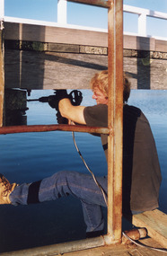
... Waterways ...Date made May 2000.Colour photograph of diving operations to attach crane cable to underwater section of piers of old North Arm bridge. Diver in water, small tinny standing by with two men aboard. Lakes Entrance Victoria.bridges, waterways, machinery, public works -
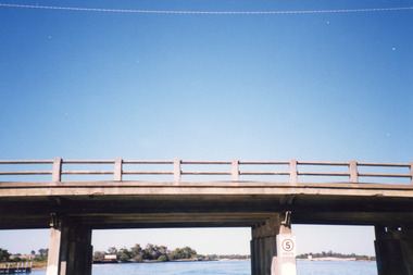
 Lakes Entrance Regional Historical Society (operating as Lakes Entrance History Centre & Museum)
Photograph, 2008
... Waterways ...Date made September 2008Colour photograph showing the new North Arm bridge opened 2000, taken from pathway besides Princes Highway at west end of Lakes Entrance, Victoria.bridges, waterways, public works, islands -
 Lakes Entrance Regional Historical Society (operating as Lakes Entrance History Centre & Museum)
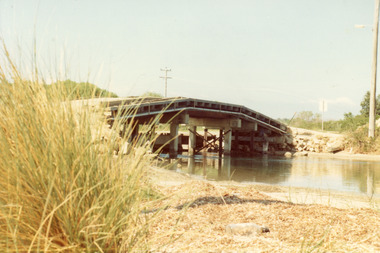
Photograph, Fish Marie, 1965
... Waterways ...Also one other photograph, similar viewColour photograph of the first road bridge from Lakes Entrance to Bullock island, which was built for Public Works Dept. groyne building and sand build up to enlarge the island. Built early 1953. Lakes Entrance Victoriawaterways, topography, transport, room display -
 Lakes Entrance Regional Historical Society (operating as Lakes Entrance History Centre & Museum)
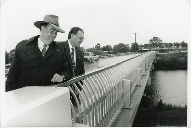
Photograph, Lakes Post Newspaper, 1995
... Waterways ...The first concrete bridge built over Tambo River at Swan Reach, in 1932 was never officially opened, so the opening of the refurbished bridge on 19 December 1995 was declared 'The Official Opening'. Photo taken at the Official Opening 19 December 1995Black and white photograph showing David Treasure, MLA, and Norm Butler of VicRoads, on the strengthened and widened bridge, over the Tambo River at Swan Reach, Victoria.bridges, waterways, animals, vegetation -
 Lakes Entrance Regional Historical Society (operating as Lakes Entrance History Centre & Museum)
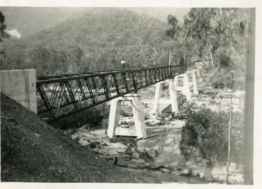
Photograph, 1990
... Waterways ...Also another photo taken laterColour photograph showing McKillops Bridge across the Snowy River in the High Country near Deddick, East Gippsland near the Victorian / NSW border, south side of bridge, road to Deddick just visible opposite end, taken from west end of bridge. River flowing to right, bridge of timber, steel and concrete, mountains around. East Gippsland Victoriabridges, accommodation, waterways, transport -
Lakes Entrance Regional Historical Society (operating as Lakes Entrance History Centre & Museum)
Photograph, 1925
... Waterways ...Black and white photograph of road bridge over the Mitchell River at Bairnsdale, Victoria.bridges, boats and boating, waterways, jetties -
 Lakes Entrance Regional Historical Society (operating as Lakes Entrance History Centre & Museum)
Photograph, Lakes Post Newspaper, 1999
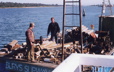
... Waterways ...Image appeared in Lakes Post 19 May 1999|Also two other photographs similarColour photograph of repairs to the Cunninghame Arm Footbridge, shows Burys Slipway barge and workmen. Surf Lifesaving Clubroom on dunes in distance. Lakes Entrance Victoriabridges, waterways, associations, topography -
 Lakes Entrance Regional Historical Society (operating as Lakes Entrance History Centre & Museum)
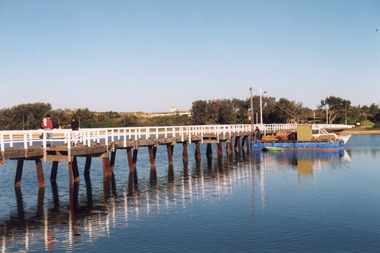
Photograph, Lakes Post Newspaper, 1999
... Waterways ...Colour photograph of the Cunninghame Arm Footbridge, . Lakes Entrancebridges, waterways, associations, topography -
 Lakes Entrance Regional Historical Society (operating as Lakes Entrance History Centre & Museum)
Photograph, Lakes Post Newspaper, 1999
... Waterways ...Colour photograph of the Cunninghame Arm Footbridge, . Lakes Entrancebridges, waterways, associations, topography -
 Lakes Entrance Regional Historical Society (operating as Lakes Entrance History Centre & Museum)
Photograph, Lakes Post Newspaper, 1999
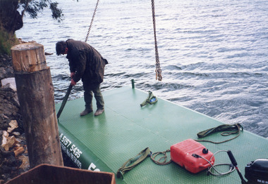
... Waterways ...Photo and article appeared in the Lakes Post Newspaper 28 July 1999|Barge was built by Wayne Smith for the firm East Gippsland Bridges.|Also two other photographs similarColour photograph of the launching of a new work barge in the Tambo River, Victoria.boats and boating, topography, waterways, celebrations