Showing 3748 items
matching west melbourne
-
 Eltham District Historical Society Inc
Slide, McCarthy Grove, Montmorency looking west near No. 27, c.Oct. 1980
One of a series of images of roads and infrastructure taken by Eltham Shire Council Planning and Engineering officers. They provide perspective of the changes in housing styles and road development that began sweeping in from the mid 1970s with increasing urbanisation of what was once more outlying suburbs and regions.35 mm colour positive transparency Mount - Kodak Kodachrome CardProcessed Oct 1980houses, infrastructure, mccarthy grove, montmorency, roads -
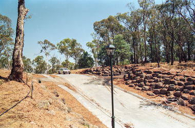
 Eltham District Historical Society Inc
Slide, Quinn Estate from Sackville Street looking west to 'T-bowl' near Main Road, Montmorency, c.Oct. 1980
One of a series of images of roads and infrastructure focussed on the Quinn Estate in Montmorency taken by Eltham Shire Council Planning and Engineering officers. They provide perspective of the changes in housing styles and road development that began sweeping in from the mid 1970s with increasing urbanisation of what was once more outlying suburbs and regions.35 mm colour positive transparency Mount - Kodak Kodachrome CardProcessed Oct 1980roads, housing estate, infrastructure, main road, montmorency, quinn estate, sackville street, t-bowl -
 Eltham District Historical Society Inc
Slide, Quinn Estate looking west along Cressy Street, Montmorency, c.Oct. 1980
One of a series of images of roads and infrastructure focussed on the Quinn Estate in Montmorency taken by Eltham Shire Council Planning and Engineering officers. They provide perspective of the changes in housing styles and road development that began sweeping in from the mid 1970s with increasing urbanisation of what was once more outlying suburbs and regions.35 mm colour positive transparency Mount - Kodak Kodachrome CardProcessed Oct 1980cressy street, housing estate, infrastructure, montmorency, quinn estate, roads -
 Eltham District Historical Society Inc
Slide, Quinn Estate looking west along Cressy Street, Montmorency near no. 29, c.Oct. 1980
One of a series of images of roads and infrastructure focussed on the Quinn Estate in Montmorency taken by Eltham Shire Council Planning and Engineering officers. They provide perspective of the changes in housing styles and road development that began sweeping in from the mid 1970s with increasing urbanisation of what was once more outlying suburbs and regions.35 mm colour positive transparency Mount - Kodak Kodachrome CardProcessed Oct 1980cressy street, housing estate, infrastructure, montmorency, quinn estate, roads -
 Eltham District Historical Society Inc
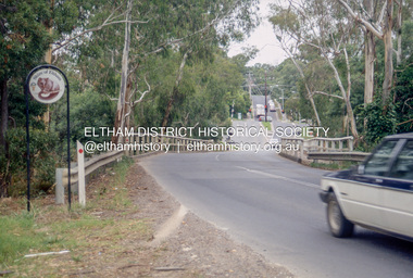
Slide - Photograph, Wattletree Road Bridge, Eltham, c.1993
35mm colour positive transparency Mount - Black and Whiteinfrastructure, roads, eltham, eltham north, level crossing, main road, park west road, railway crossing, sign, wattletree road, wattletree road bridge -
 Eltham District Historical Society Inc
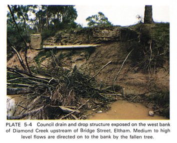
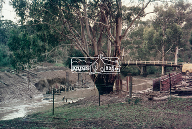
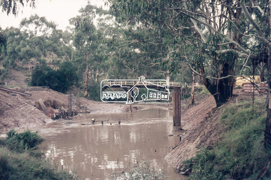
Work on paper (Sub-Item) - Photograph, Council drain and drop structure exposed on the west bank of Diamond Creek upstream of Bridge Street, Eltham
Colour photograph of a muddy creek (probably after a downpour) showing council drain and drop structure exposed on the west bank of Diamond Creek upstream of Bridge Street, Eltham. Mediun to high level water flows are directed on to the bank by the fallen tree.eltham, creek, diamond creek, bridge street, drainage, waterflow, vegetation -
 Eltham District Historical Society Inc
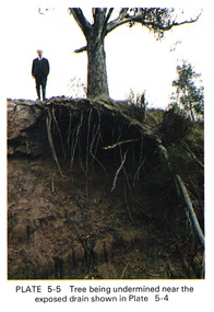
Work on paper (Sub-Item) - Photograph, Tree being undermined near an exposed drain on the west bank of Diamond Creek upstream of Bridge Street, Eltham
Colour photograph of tree on the side of the Diamond Creek upstream at Bridge Street, Eltham. The tree has been undermined with roots exposed near a council drain.eltham, diamond creek, bridge street, drainage, roots, tree -
 Eltham District Historical Society Inc
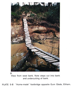
Work on paper (Sub-Item) - Photograph, Home-made footbridge across Diamond Creek, opposite Gum Glade, Eltham
Colour photograph of home-made footbridge across the Diamond Creek opposite Gum Glade, Eltham. View from west bank. Note steps cut into bank and undercutting of bankeltham, diamond creek, footbridge, gum glade, creek bank -
 Eltham District Historical Society Inc
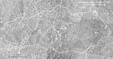
Work on paper (Sub-Item) - Photograph, St Helena East, St Helena West and Eltham West drains, ca 1980
black and white aerial photograph with boundary and drains marked over three page fold out eltham, st helena, drains, aerial view -
 Eltham District Historical Society Inc
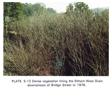
Work on paper (Sub-Item) - Photograph, Dense vegetaton lining the Eltham West Drain downstream of Bridge Street in 1976, 1976
Colour photograph of dense vegetation lining the Eltham West drain downstream of Bridge Street, Elthameltham, vegetation, weeds, eltham west drain -
 Eltham District Historical Society Inc
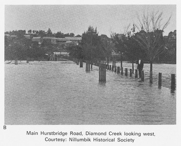
Work on paper (Sub-Item) - Photograph, Main Hurstbridge Road, Diamond Creek looking west
Undated black and white photograph of Main Hurstbridge Road, Diamond Creek in flood looking west. Nillumbik Historical Society collectionflood, diamond creek, nillumbik historical society -
 Eltham District Historical Society Inc
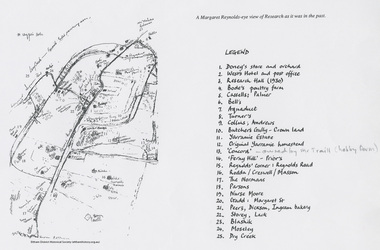
Document - Map, Margaret Reynolds, A Margaret Reynolds-eye view of Reseach as it was in the past, 1989
Reproduced in Return to Research : a centenary history of Research Primary School / edited by Andrew LemonA4 photocopy andrews, bell, blashik, bode's poultry farm, butchers gully, cassells, collins, concord, creswell, dickson, doney's store, dry creek, ferny hill, gadd, ingram bakery, lack, margaret reynolds, margaret street, maroondah aqueduct, masson, moseley, normans, nurse moore, palmer, parsons, peers, prior, research (vic.), research hall, reynolds corner, reynolds road, rodda, storey, traill property, turner, west's hotel, yarramie estate -
 Eltham District Historical Society Inc
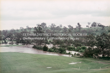
Slide, Floodwater, west from Clubhouse of Rosanna Golf Club, Lower Plenty, November 1971, 1971
Many parts of Melbourne flooded including Rosanna Golf Club, Lower Plenty in Novembere 1971. Many surburban roads, including the new south-eastern freeway were cut by flood waters. Here the level of the Plenty River floods onto the golf course. 35 mm colour positive transparency Mount - Agfacolor Service (Blue)floods, lower plenty, rosanna golf club, flooding, plenty river -
 Eltham District Historical Society Inc
Slide, Construction of new bridge, looking downstream from west bank towards existing Lintons Bridge across Arthurs Creek, Doctors Gully Road, Nutfield, 22 February 1972, 1972
35 mm colour positive transparency Mount - Agfacolor Service (Blue)arthurs creek, bridge construction, doctors gully road, eltham shire council, infrastructure, lintons bridge, nutfield -
 Eltham District Historical Society Inc
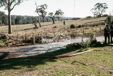
Slide, On the east side of Bonds Road looking west onto Martin's property, Lower Plenty, 18 July 1972, 1972
Water drainage work undertaken by Eltham Shire Council in Bonds Road, Lower Plenty outside the Martin property opposite Montpelier Drive, July 1972 35 mm colour positive transparency Mount - Agfacolor Service (Blue)Bonds Road (Martin property) 12.10 pm 18.7.72bonds road, drainage works, eltham shire council, infrastructure, lower plenty, martin property, montpelier drive -
 Eltham District Historical Society Inc
Slide, West side of Bonds Road at culvert end wall, Lower Plenty, 18 July 1972, 1972
Water drainage work undertaken by Eltham Shire Council in Bonds Road, Lower Plenty outside the Martin property opposite Montpelier Drive, July 1972 Pitchers in foreground were part of the end wall which was eroded out due to water crossing the road and not going through the culvert. 35 mm colour positive transparency Mount - Agfacolor Service (Blue)Bonds Road (Martin property) 12.10 pm 18.7.72bonds road, drainage works, eltham shire council, infrastructure, lower plenty, martin property, montpelier drive -
 Eltham District Historical Society Inc
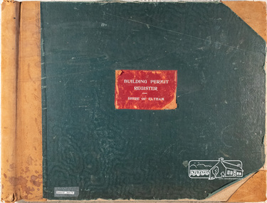
Register, Building Permit Register, Shire of Eltham, 1949-1960, 1949-1960
Register Book, Hard cover, tan suede leather bound spine and corners on both covers, with green fabric on 5mm thick covers. Red fabric in centre of front cover with "Building Permit Register - Shire of Eltham" lightly embossed with silver print. 39.0 x 52.5 x 6.5 cm Arnall & Jackson label on inside end sheets ( both ends), Printers, Lithographers, Bookbinders, Publishers, Manufacturing Stationers, 115 Barkly St. West, Brunswick, Repeat Order No. A27956 Special print with each page headed with "Shire of Eltham", divide into columns of Date, Description, Lot No., Locality, L.P. or C.A., Riding, Cost, Owner name and address, Builder name and address, Application, Permit No. Commenced, Completed, Capital Value, N.A.V. Typically, last three columns not filled in. 326 pages arranged in Alphabetical tabs; 133 pages with entries. Label adhered to front cover "Series 67 Item 79"shire of eltham archives, building permit register, shire of eltham -
 Eltham District Historical Society Inc
Book, Diamond Creek Basin Study. Part 1, A Compendium of Factors Relevant to Stormwater Flows, 1980
Basin Studies are studies to evaluate water supply and demand and help ensure reliable water supplies by identifying strategies to address imbalances in water supply and demand.Spiral Bound. 157 leaves in various foliations (some folded) : illustrated. (some colour.), maps (some colour.)aerial photographs, allendale road, arthurs creek mine, arthurs creek road bridge, arthurs creek, bald spur look-out, bank protection, bolton steet, bridge street bridge, bridge street, bridges, challenger street, chute street, construction, coolaroo drive, culvert, deep creek, diamond creek basin, diamond creek region, diamond creek, diamond street bridge, drainage works, eltham lower park, eltham town park, eltham trestle bridge, eltham west drains, eltham, erosion, flood management, floods, footbridge, glen katherine estate, gold mining, gum glade, hurstbridge, kangaroo ground, kinglake escarpment, kinglake national park, latiners hat factory, main road bridge, main road, masons falls, melbourne metropolitan board of works, monash bridge, mount sugarloaf, nillumbik park, orchards, railway culvert, railway line, ramptons road, real estate advertisement, research creek, st helena east drain, st helena road, st helena, storm sewers, stormwater, sugarloaf-preston transfer main crossing, susan street, union mine, village pond, water flow, watkins street, wattletree road, weidlich road, wingrove park, yarra river, zig zag road, water supply, basin study -
 Eltham District Historical Society Inc
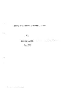
Document - Folder, Look West from Eltham Station by Derek Sawer, June 2000
Folder no 65 of the Harry Gilham collection. Reminscences writiten by Peter Sawer, also known as Peter Sawer about living in Eltham after the war from 1945 in the development west of the railway station known as Highbrow Hill. Preface written by Diana Bassett-Smith5 pagesharry gilham collection, reminiscences, derek sawer, peter sawer, diana bassett-smith, john harcourt, housing -
 Eltham District Historical Society Inc
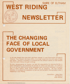
Newspaper - Folder, Shire of Eltham, West Riding Newsletter, 1978
Newsletter produced by the Shire of Eltham including introduction titled: "The changing face of local government", signed by Ward councillors: Helen Wells, Neil Roberts and Allan Horsley, a brief financial statement: "where the money comes from", roads, shopping centres, council/education department projects, land purchase, senior citizens and recreation include list of new construction and upgrades. Folder 71 from Harry Gilham Collection4 pages. Foldedallan horsley, community services, shire of eltham, budget, roads, shoppping centres, briar hill, montmorency, recreation, helen wells, neil roberts -
 Eltham District Historical Society Inc
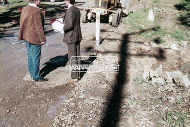
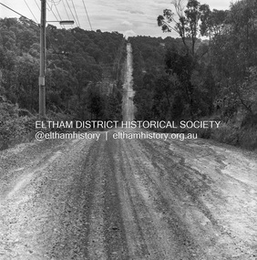
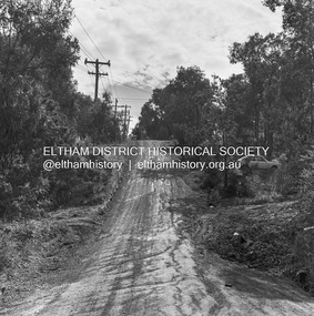
Photograph, Michael Wood, Progress Road looking west from Lower Road, Eltham North, 1976, 1976
Progress Road between Ryans Road and Lower Road, Eltham North; prior to realignment and construction, 1976Kodak Safety Film 120 format 6 x 6 cm black and white negative; 3 strips, 12 frameseltham north, lower road, progress road, road construction -
 Eltham District Historical Society Inc
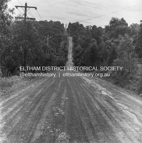
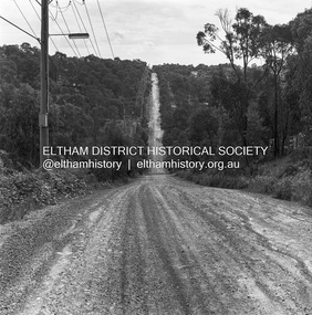
Photograph, Michael Wood, Progress Road looking west towards intersection with Ryans Road, Eltham North, 1976, 1976
Progress Road between Ryans Road and Lower Road, Eltham North; prior to realignment and construction, 1976Kodak Safety Film 120 format 6 x 6 cm black and white negative; 3 strips, 12 frameseltham north, ryans road, progress road, road construction -
 Eltham District Historical Society Inc
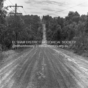
Photograph, Michael Wood, Progress Road looking west towards intersection with Ryans Road, Eltham North, 1976, 1976
Progress Road between Ryans Road and Lower Road, Eltham North; prior to realignment and construction, 1976Kodak Safety Film 120 format 6 x 6 cm black and white negative; 3 strips, 12 frames Also 30 x 25 cm black and white print of this image frameeltham north, progress road, road construction -
 Eltham District Historical Society Inc
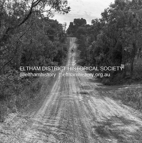
Photograph, Michael Wood, Progress Road looking west towards intersection with Ryans Road, Eltham North, 1976, 1976
Progress Road between Ryans Road and Lower Road, Eltham North; prior to realignment and construction, 1976Kodak Safety Film 120 format 6 x 6 cm black and white negative; 3 strips, 12 frames Also 30 x 25 cm black and white print of this image frameeltham north, progress road, road construction, ryans road -
 Eltham District Historical Society Inc
Photograph, Michael Wood, Progress Road looking west from Lower Road, Eltham North, 1976, 1976
Progress Road between Ryans Road and Lower Road, Eltham North; prior to realignment and construction, 1976Kodak Safety Film 120 format 6 x 6 cm black and white negative; 3 strips, 12 frames Also 30 x 25 cm black and white print of this image frameeltham north, progress road, road construction, lower road -
 Eltham District Historical Society Inc
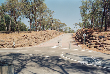
Photograph, Looking west up Nerreman Gateway from intersection with Ryans Road, Eltham, c.1992, 1992c
Gordon Ford landscape design at entrance to Nerreman Gateway.Roll of 35mm colour negative film, 7 strips Fuji 100eltham, gordon ford, nerreman gateway, nerreman park estate, ryans road,streets -
 Eltham District Historical Society Inc
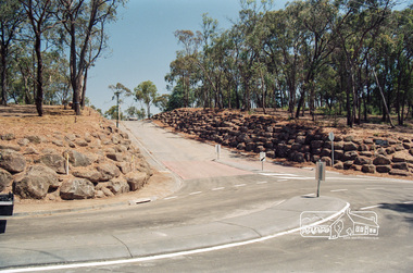
Photograph, Looking west up Nerreman Gateway from intersection with Ryans Road, Eltham, c.1992, 1992c
Gordon Ford landscape design at entrance to Nerreman Gateway.Roll of 35mm colour negative film, 7 strips Fuji 100eltham, gordon ford, nerreman gateway, nerreman park estate, ryans road,streets -
 Eltham District Historical Society Inc
Photograph, Looking west up Nerreman Gateway from intersection with Ryans Road, Eltham, c.1992, 1992c
Gordon Ford landscape design at entrance to Nerreman Gateway.Roll of 35mm colour negative film, 7 strips Fuji 100eltham, gordon ford, nerreman gateway, nerreman park estate, ryans road,streets