Showing 1189 items
matching yarra river -- melbourne
-
 Kew Historical Society Inc
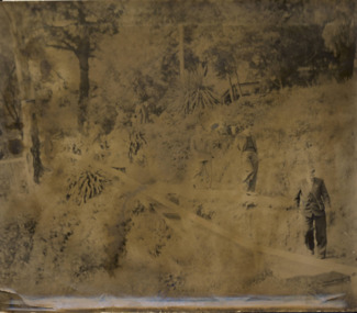
Photograph - Men on the bank of the Yarra River, circa 1953
... on the bank of the Yarra River Australia Victoria Melbourne ...This is one of a series of 17 black and white undated photographic proofs donated to the Kew Historical Society in 2013 by the Queenscliffe Historical Museum. The series includes images of individuals, tea rooms, ferries, motor launches, ocean liners and tugs. The subject of the photograph is a Hicks Bros ferry, which from circa 1921 operated a ferry service from Princess Walk (Melbourne) to Studley Park.Very faded and degraded photograph of a group of men walking down pathways on the bank of a river in Melbourne. The location may be the Hawthorn Tea Rooms. The undated photographic positive was probably taken in the 1950s.melbourne, tourism -
 Kew Historical Society Inc
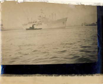
Photograph - Port of Melbourne, circa 1953
This is one of a series of 17 black and white undated photographic proofs donated to the Kew Historical Society in 2013 by the Queenscliffe Historical Museum. The series includes images of individuals, tea rooms, ferries, motor launches, ocean liners and tugs. One of two faded black and white photographic proofs of a tugboat and an ocean liner in the Port of Melbourneyarra river, tugboats, shipping, ships, port of melbourne -
 Kew Historical Society Inc
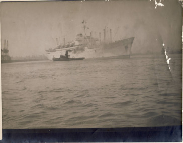
Photograph - Port of Melbourne, circa 1953
This is one of a series of 17 black and white undated photographic proofs donated to the Kew Historical Society in 2013 by the Queenscliffe Historical Museum. The series includes images of individuals, tea rooms, ferries, motor launches, ocean liners and tugs. One of two faded black and white photographic proofs of a tugboat and an ocean liner in the Port of Melbourneyarra river, tugboats, shipping, ships, port of melbourne -
 Kew Historical Society Inc
Journal, Kew Historical Society, Newsletter No.138, March 2022
Exhibitions and grants / Robert Baker p1. Office Bearers / p2. History News: acquisitions; Victorian Collections; grants & sponsors; 2022 McIntyre Lecture / p3. Madford: a former mansion in Wellington Street / Robert Baker p4. Life on the River: Macauley's Boathouse / Julie King p5. What's A Quoll? - lively and appealing squirrel-like spotted cats / Suzanne McWha p7. In March 1922 / Trove p8. A Coronation Dress: from Westminster Abbey to Kew / Suzanne McWha & Felicity Renowden p9. The Yarra Yarra Jazz Band / Brad Miles p11. Membership & Donations p12.Published quarterly since 1977, the newsletters of the Kew Historical Society contain significant research by members exploring relevant aspects of the Victorian and Australian Framework of Historical Themes. Frequently, articles on people, places and artefacts are the only source of information about an aspect of Kew, and Melbourne’s history.non-fictionExhibitions and grants / Robert Baker p1. Office Bearers / p2. History News: acquisitions; Victorian Collections; grants & sponsors; 2022 McIntyre Lecture / p3. Madford: a former mansion in Wellington Street / Robert Baker p4. Life on the River: Macauley's Boathouse / Julie King p5. What's A Quoll? - lively and appealing squirrel-like spotted cats / Suzanne McWha p7. In March 1922 / Trove p8. A Coronation Dress: from Westminster Abbey to Kew / Suzanne McWha & Felicity Renowden p9. The Yarra Yarra Jazz Band / Brad Miles p11. Membership & Donations p12.kew historical society (vic.) -- periodicals., kew historical society (vic.) -- newsletters, kew historical society (vic.) -- journals -
![Junction of the Rivers Yarra and Watt, Near Healesville / [by] Nicholas Caire, circa 1876](/media/collectors/550653872162f11fb04854aa/items/577740e5d0cdd10a5c0de011/item-media/57774153d0cdd10a5c0e0662/item-fit-380x285.jpg) Kew Historical Society Inc
Kew Historical Society IncPhotograph, Anglo-Australasian Photographic Company, Junction of the Rivers Yarra and Watt, Near Healesville, c. 1876
Nicholas Caire was born on Guernsey in the Channel Islands in 1837. He arrived in Adelaide with his parents in about 1860. In 1867, following photographic journeys in Gippsland, he opened a studio in Adelaide. From 1870 to 1876 he lived and worked in Talbot in Central Victoria. In 1876 he purchased T. F. Chuck's studios in the Royal Arcade Melbourne. In 1885, following the introduction of dry plate photography, he began a series of landscape series, which were commercially successful. As a photographer, he travelled extensively through Victoria, photographing places few of his contemporaries had previously seen. He died in 1918. Reference: Jack Cato, 'Caire, Nicholas John (1837–1918)', Australian Dictionary of Biography.An original, rare photograph from the series 'Views of Victoria: General Series' by the photographer, Nicholas Caire (1837-1918). The series of 60 photographs that comprise the series was issued c. 1876 and reinforced a neo-Romantic view of the Australian landscape to which a growing nationalist movement would respond. Nicholas Caire was active as a photographer in Australia from 1858 until his death in 1918. His vision of the Australian bush and pioneer life had a counterpart in the works of Henry Lawson and other nationalist poets, authors and painters.Albumen Silver Photograph, mounted on Board.printed in ink on support l.c.: JUNCTION OF THE RIVERS YARRA AND WATT, NEAR HEALESVILLE. / COPYRIGHT REGISTERED. printed in ink on support reverse c.: VIEWS OF VICTORIA. / (GENERAL SERIES.) / No. 3. / JUNCTION OF THE RIVERS YARRA AND WATT, NEAR HEALESVILLE / The junction is situated about 3 miles from Healesville, and 35 miles from the mouth of the Yarra. The souces / of the Watt are to be found at the head of the Black Spur, and, being fed by a number of creeks and springs, its / waters gain considerable force for several miles before joining those of the Yarra. The "Old Bridge," at the junction, / is the name given to this crossing-place, which has been partly swept away by late floods. The depth of the Yarra here / is from 15 to 20 feet; that of the Watt, about 10 feet. printed in ink on support reverse l.c.l.: J.W. FORBES, Agent, printed in ink on support reverse l.c.: ANGLO-AUSTRALASIAN PHOTOGRAPHIC COMPANY, MELBOURNE. printed in ink on support reverse l.c.r.: 10 Temple Court, Collins Street West.nicholas caire (1837-1918), yarra river, watt river, bridge, wooden bridge, healesville -
![Scene near Corranderrk Station / [by] Nicholas Caire, circa 1876](/media/collectors/550653872162f11fb04854aa/items/57774ae0d0cdd10a5c12f2d7/item-media/57774b61d0cdd10a5c132dac/item-fit-380x285.jpg) Kew Historical Society Inc
Kew Historical Society IncPhotograph, Anglo-Australasian Photographic Company, Scene near Corranderrk Station, c. 1876
Nicholas Caire was born on Guernsey in the Channel Islands in 1837. He arrived in Adelaide with his parents in about 1860. In 1867, following photographic journeys in Gippsland, he opened a studio in Adelaide. From 1870 to 1876 he lived and worked in Talbot in Central Victoria. In 1876 he purchased T. F. Chuck's studios in the Royal Arcade Melbourne. In 1885, following the introduction of dry plate photography, he began a series of landscape series, which were commercially successful. As a photographer, he travelled extensively through Victoria, photographing places few of his contemporaries had previously seen. He died in 1918. Reference: Jack Cato, 'Caire, Nicholas John (1837–1918)', Australian Dictionary of Biography. The 1860s marked the beginning of the era of reserves and missions. Six Aboriginal reserves were established during the 1860s. These were under the control of the Board for the Protection of Aborigines. Four were Christian missions receiving government aid. These were Lake Tyers (Anglican) and Ramahyuck (Presbyterian/Moravian) in eastern Victoria for the Gunai/Kurnai clans; Ebenezer (Moravian) in north-west Victoria for the clans of the Wimmera and Lower Murray; and Lake Condah (Anglican) in south-west Victoria. The other two were secular government controlled reserves: Framlingham which, like Lake Condah, was established for the Mara-speaking Gunditjmara and Kirrae-wurrung people of south-west Victoria; and Coranderrk, located about 60 kilometres north-east of Melbourne, for the Kulin clans of central Victoria. In 1863, after a period of devastation to the Kulin people, Coranderrk was established at the junction of the Yarra River and Badger Creek. Reference: http://coranderrk.com/, accessed 24 December 2016An original, rare photograph from the series 'Views of Victoria: General Series' by the photographer, Nicholas Caire (1837-1918). The series of 60 photographs that comprise the series was issued c. 1876 and reinforced a neo-Romantic view of the Australian landscape to which a growing nationalist movement would respond. Nicholas Caire was active as a photographer in Australia from 1858 until his death in 1918. His vision of the Australian bush and pioneer life had a counterpart in the works of Henry Lawson and other nationalist poets, authors and painters.Albumen silver photograph mounted on boardprinted in ink on support l.c.: SCENE NEAR "CORRANDERRK" STATION. / COPYRIGHT REGISTERED. printed in ink on support reverse c.: VIEWS OF VICTORIA. / (GENERAL SERIES.) / No. 9. / SCENE NEAR "CORRANDERRK" STATION. / This scene was taken from the hill near Rourke's Bridge, on the Healesville Road, and displays in the foreground / the River Yarra. The roadway which is seen in the mid-distance has lately been constructed by the Government, / as the old tracks which formerly existed, were liable to be swamped by the periodical overflowing of the River. Mount / Ridell can be seen in the extreme distance immediately behind the roadway. / Corranderrk is the local habitation / for the natives of this district, and is situated on the right hand side of the picture, about a mile and a half / from the roadway. printed in ink on support reverse l.c.l.: J.W. FORBES, Agent, printed in ink on support reverse l.c.: ANGLO-AUSTRALASIAN PHOTOGRAPHIC COMPANY, MELBOURNE. printed in ink on support reverse l.c.r.: 10 Temple Court, Collins Street West.nicholas caire (1837-1918), coranderrk aboriginal station, aborigine, yarra river, badger creek, first peoples, aboriginal and torres straight islander -
![Scene on the Yarra, near Rourke's Bridge / [by] Nicholas Caire, circa 1876](/media/collectors/550653872162f11fb04854aa/items/5777571cd0cdd10a5c191a9c/item-media/57775788d0cdd10a5c193e0d/item-fit-380x285.jpg) Kew Historical Society Inc
Kew Historical Society IncPhotograph, Anglo-Australasian Photographic Company, Scene on the Yarra, near Rourke's Bridge, c. 1876
Nicholas Caire was born on Guernsey in the Channel Islands in 1837. He arrived in Adelaide with his parents in about 1860. In 1867, following photographic journeys in Gippsland, he opened a studio in Adelaide. From 1870 to 1876 he lived and worked in Talbot in Central Victoria. In 1876 he purchased T. F. Chuck's studios in the Royal Arcade Melbourne. In 1885, following the introduction of dry plate photography, he began a series of landscape series, which were commercially successful. As a photographer, he travelled extensively through Victoria, photographing places few of his contemporaries had previously seen. He died in 1918. Reference: Jack Cato, 'Caire, Nicholas John (1837–1918)', Australian Dictionary of BiographyAn original, rare photograph from the series 'Views of Victoria: General Series' by the photographer, Nicholas Caire (1837-1918). The series of 60 photographs that comprise the series was issued c. 1876 and reinforced a neo-Romantic view of the Australian landscape to which a growing nationalist movement would respond. Nicholas Caire was active as a photographer in Australia from 1858 until his death in 1918. His vision of the Australian bush and pioneer life had a counterpart in the works of Henry Lawson and other nationalist poets, authors and painters.Albumen silver photograph mounted on boardprinted in ink on support l.c.: SCENE ON THE YARRA, NEAR ROURKE'S BRIDGE. / COPYRIGHT REGISTERED. printed in ink on support reverse c.: VIEWS OF VICTORIA. / (GENERAL SERIES.) / No. 16. / SCENE ON THE YARRA, NEAR ROURKE'S BRIDGE. / The subject of the present illustration represents the New Bridge crossing the River Yarra on the road from / St. Huberts to the Native Station at Corranderrk, and to the township at Healesville. The river at this place abounds / with fish of a large description, which are caught by the Natives, frequently in considerable quantitities. printed in ink on support reverse l.c.l.: J.W. FORBES, Agent, printed in ink on support reverse l.c.: ANGLO-AUSTRALASIAN PHOTOGRAPHIC COMPANY, MELBOURNE. printed in ink on support reverse l.c.r.: 10 Temple Court, Collins Street West.nicholas caire (1837-1918), landscape photography - victoria -
 Kew Historical Society Inc
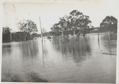
Photograph, Willsmere Bridge, 1934
Several boathouses were built in Kew and Fairfield in the late 19th and early 20th centuries. They included Chipperfield’s ‘Moorings’ and floating pontoon. The substantial two-storey house was named the Moorings, and incorporated an upper storey residence. The Moorings was almost washed away in the 1916 floods, and in 1934 almost totally submerged when the Yarra River rose 26 feet in 14 hours. Following the 1934 flood, the house was restored. The floating pontoon, sometimes referred to as a ‘kiosk’ or ‘canteen’, was used to store canoes. Both were removed in 1972 for the construction of the Eastern Freeway.This work forms part of the collection assembled by the historian Dorothy Rogers, that was donated to the Kew Historical Society by her son John Rogers in 2015. The manuscripts, photographs, maps, and documents were sourced by her from both family and local collections or produced as references for her print publications. Many were directly used by Rogers in writing ‘Lovely Old Homes of Kew’ (1961) and 'A History of Kew' (1973), or the numerous articles on local history that she produced for suburban newspapers. Most of the photographs in the collection include detailed annotations in her hand. The Rogers Collection provides a comprehensive insight into the working habits of a historian in the 1960s and 1970s. Together it forms the largest privately-donated collection within the archives of the Kew Historical Society.A view of flooded areas in North Kew in the flood of 1934.Willsmere Bridge. Chipperfields. 1934 floodwillsmere, flood, yarra flood, chipperfields, chipperfields boathouse, north kew -
 Kew Historical Society Inc
Photograph, Cattle in North Kew floods, 1934
The year 1934 witnessed the greatest flooding of the Yarra River since settlement. This work forms part of the collection assembled by the historian Dorothy Rogers, that was donated to the Kew Historical Society by her son John Rogers in 2015. The manuscripts, photographs, maps, and documents were sourced by her from both family and local collections or produced as references for her print publications. Many were directly used by Rogers in writing ‘Lovely Old Homes of Kew’ (1961) and 'A History of Kew' (1973), or the numerous articles on local history that she produced for suburban newspapers. Most of the photographs in the collection include detailed annotations in her hand. The Rogers Collection provides a comprehensive insight into the working habits of a historian in the 1960s and 1970s. Together it forms the largest privately-donated collection within the archives of the Kew Historical Society.Photograph of floodwaters encroaching on farm land in North Kew in the flood of 1934.Nth. Kew. 1934 Floodsfloods (melbourne) 1934, dorothy rogers -
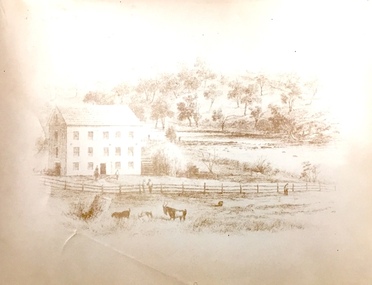
 Kew Historical Society Inc
Print, Dight's Mill, Yarra Yarra
"In 1839 John Dight purchased Melbourne block 88, which included 26 acres of land along the Yarra River for £481 at the Port Phillip land sales held in Sydney. Dight was already in the business of flour milling and had a mill near Campbell Town in New South Wales called ‘Ceres’. In April 1840, he notified his customers through The Sydney Herald that he was leaving to go to Port Phillip. The first steam powered flour mill was constructed in Melbourne in 1841. Dight built his water powered mill, soon after, from bricks bought over from Tasmania. Dight used the river to power his mill: Water flowed along an inlet channel to turn an undershot water wheel. In order to regulate flow or to ensure flow for times when river levels were low, Dight constructed a rough stone weir. " (https://www.melbournewater.com.au/whatwedo/projectsaroundmelbourne/Documents/A_Short_History_of_Dights_Falls_Fact_Sheet.pdf) This work forms part of the collection assembled by the historian Dorothy Rogers, that was donated to the Kew Historical Society by her son John Rogers in 2015. The manuscripts, photographs, maps, and documents were sourced by her from both family and local collections or produced as references for her print publications. Many were directly used by Rogers in writing ‘Lovely Old Homes of Kew’ (1961) and 'A History of Kew' (1973), or the numerous articles on local history that she produced for suburban newspapers. Most of the photographs in the collection include detailed annotations in her hand. The Rogers Collection provides a comprehensive insight into the working habits of a historian in the 1960s and 1970s. Together it forms the largest privately-donated collection within the archives of the Kew Historical Society.An engraving of Dight's Mill on the Yarra. The image was originally published in Sands & Kenny, Melbourne & Sydney. Dorothy Rogers reproduced the print in 'A History of Kew' (1973). It faces page 8.Published by Sands & Kenny, Melbourne & Sydney, 1856dight's mill, dorothy rogers, dight's falls, yarra river, kew, john dight -
 Kew Historical Society Inc
Photograph, Chipperfield's Boat House & Floating Pontoon, c.1939
Several boathouses were built in Kew and Fairfield in the late 19th and early 20th centuries. They included Chipperfield’s ‘Moorings’ and floating pontoon. The substantial two-storey house was named the Moorings, and incorporated an upper storey residence. The Moorings was almost washed away in the 1916 floods, and in 1934 almost totally submerged when the Yarra River rose 26 feet in 14 hours. Following the 1934 flood, the house was restored. The floating pontoon, sometimes referred to as a ‘kiosk’ or ‘canteen’, was used to store canoes. Both were removed in 1972 for the construction of the Eastern Freeway.This work forms part of the collection assembled by the historian Dorothy Rogers, that was donated to the Kew Historical Society by her son John Rogers in 2015. The manuscripts, photographs, maps, and documents were sourced by her from both family and local collections or produced as references for her print publications. Many were directly used by Rogers in writing ‘Lovely Old Homes of Kew’ (1961) and 'A History of Kew' (1973), or the numerous articles on local history that she produced for suburban newspapers. Most of the photographs in the collection include detailed annotations in her hand. The Rogers Collection provides a comprehensive insight into the working habits of a historian in the 1960s and 1970s. Together it forms the largest privately-donated collection within the archives of the Kew Historical Society.Chipperfield's Floating Canteen (also known as the pontoon) on the Yarra River. at North Kew The children wading in the river are believed to be the three sons of Dorothy Rogers."Chipperfield's Floating Canteen & house in background. At extreme right - observe channel where Connors Creek flows in."chipperfield's boat house, river yarra, dorothy rogers, floods 1916, 1934 -
 Kew Historical Society Inc
Plan, Studley Park Estate, 1910
Prue Sanderson, in her groundbreaking ‘City of Kew Urban Conservation Study : Volume 2 - Development History’ (1988), summarised the periods of urban development and subdivisions of land in Kew. The periods that she identified included 1845-1880, 1880-1893, 1893-1921, 1921-1933, 1933-1943, and Post-War Development. These periods were selected as they represented periods of rapid growth or decline in urban development. An obvious starting point for Sanderson’s groupings involved population growth and the associated economic cycles. These cycles also highlighted urban expansion onto land that was predominantly rural, although in other cases it represented the decline and breakup of large estates. A number of the plans in the Kew Historical Society’s collection can also be found in other collections, such as those of the State Library of Victoria and the Boroondara Library Service. A number are however unique to the collection.The Kew Historical Society collection includes almost 100 subdivision plans pertaining to suburbs of the City of Melbourne. Most of these are of Kew, Kew East or Studley Park, although a smaller number are plans of Camberwell, Deepdene, Balwyn and Hawthorn. It is believed that the majority of the plans were gifted to the Society by persons connected with the real estate firm - J. R. Mathers and McMillan, 136 Cotham Road, Kew. The Plans in the collection are rarely in pristine form, being working plans on which the agent would write notes and record lots sold and the prices of these. The subdivision plans are historically significant examples of the growth of urban Melbourne from the beginning of the 20th Century up until the 1980s. A number of the plans are double-sided and often include a photograph on the reverse. A number of the latter are by noted photographers such as J.E. Barnes.Coloured lithograph of a subdivision plan of the Studley Park Estate, bordered by Yarra, Willsmere Road and the Outer Circle Railway line. The estate was listed in 1910 and was the subject of a planning dispute between the developer and the Town of Kew in relation to flood levels and the suitability of the land for housing. In many cases the names of streets were subsequently changed. The layout was also affected by the creation of the Eastern Freeway. A newspaper report of the day described the subdivision as a: "GOLDEN OPPORTUNITY. We are pleased to submit for PRIVATE SALE that magnificent ESTATE, situated only 4 1/2 miles from the Melbourne General Post Office, STUDLEY PARK ESTATE. KF/NV. Doubtless the CHEAPEST LAND EVER OFFERED having extensive frontages to the prettiest spot on the River Yarra and the National Park, commanding lovely river and landscape views, and acknowledged to be the finest land available so close to the city. The PRICES ARE EXTREMELY MODERATE; The TERMS ARE SIMPLY MARVELLOUS. NO DEPOSIT. NO DEPOSIT. NO DEPOSIT. Allotments and prices to suit everyone."subdivision plans - kew, studley park estate -
 Kew Historical Society Inc
Plan - Subdivision Plan, Riversdale Estate, 1939
The Kew Historical Society collection includes almost 100 subdivision plans pertaining to suburbs of the City of Melbourne. Most of these are of Kew, Kew East or Studley Park, although a smaller number are plans of Camberwell, Deepdene, Balwyn and Hawthorn. It is believed that the majority of the plans were gifted to the Society by persons connected with the real estate firm - J. R. Mathers and McMillan, 136 Cotham Road, Kew. The Plans in the collection are rarely in pristine form, being working plans on which the agent would write notes and record lots sold and the prices of these. The subdivision plans are historically significant examples of the growth of urban Melbourne from the beginning of the 20th Century up until the 1980s. A number of the plans are double-sided and often include a photograph on the reverse. A number of the latter are by noted photographers such as J.E. Barnes.The Riversdale Estate in Hawthorn created a subdivision of 20 allotments bordering on Riversdale Road and Riversdale Court (which was created by the subdivision). The Locality Plan at right lists the major public buildings in the area: Burnely Horticultural Gardens, Hawthorn Tram Depot and Railway Station, Scotch College and the River Yarra and The Boulevard.subdivision plans - hawthorn, riversdale estate -
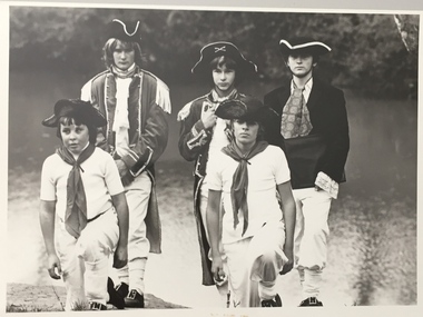
 Kew Historical Society Inc
Photograph, Standard Newspapers, Charles Grimes Re-enactment, Yarra River, 1978
The party of the British surveyor Charles Grimes were the first Europeans to view the River Yarra, as it was later to be named. Members of the party reached the area now known as Studley Park in 1803. This local re-enactment commemorated 175 years since that event. Charles Grimes Re-Enactment, Yarra River, Kew, 1978. The photograph is of a student of Trinity Grammar School and the Mayor of Kew, Cr. Whiting. Inscription on reverse: "KH-161. Society's contribution to the 1978 Festival of Kew. Re-enactment of first white man's journey and discovery of the Yarra River and the area now know (sic) as Kew. 1978. This was in the year 1903 when Grimes and party came upon the Yarra to seek a possible site for a new convict settlement. Cr. Whiting, Mayor of Kew, receiving the report from Grimes, 'Andrew Allen'. Cr. Hutchinson in top hat 'town cryer'. Bush band in backround." Ripped stamp on reverse: "Standard N[ewspapers]."charles grimes re-enactment, trinity grammar school, cr whiting -- mayors -- kew (vic.), yarra river, andrew allen, kew historical society -
 Kew Historical Society Inc
Photograph, Standard Newspapers, Charles Grimes Re-enactment, Yarra River, 1978
The party of the British surveyor Charles Grimes were the first Europeans to view the River Yarra, as it was later to be named. Members of the party reached the area now known as Studley Park in 1803. This local re-enactment commemorated 175 years since that event.Charles Grimes, Re-enactment, Yarra River, Kew, 1978. Inscription on reverse: "Trinity Grammar School students taking part in Grimes' journey up the Yarra, 1803. Re-enactment Historical Society Kew contribution to the 1978 Festival of Kew."charles grimes re-enactment, trinity grammar school, cr whiting -- mayors -- kew (vic.), yarra river, andrew allen, kew historical society -
 Kew Historical Society Inc
Photograph, Standard Newspapers, Charles Grimes Re-enactment, Yarra River, 1978
The party of the British surveyor Charles Grimes were the first Europeans to view the River Yarra, as it was later to be named. Members of the party reached the area now known as Studley Park in 1803. This local re-enactment commemorated 175 years since that event.Charles Grimes, Re-enactment, Yarra River, Kew, 1978. Inscription on reverse: "KH-191. Grimes' party in boat on Yarra 1978. Re-enactment organised by Kew Historical Society. Actors Trinity Grammar boys. Mrs Argyle's History class." Sticker on back: "771. Standard News. WHS. Festival. 4 cols. May 3. [Page] 5."charles grimes re-enactment, yarra river (kew) 1978, cr whiting (mayor of kew), andrew allen, trinity grammar school, kew historical society -
 Kew Historical Society Inc
Print, Sands & Kenny, Dights Mill, 1856
... stone weir." (Melbourne Water) dights mill yarra river ..."In 1839 John Dight purchased Melbourne block 88, which included 26 acres of land along the Yarra River for £481 at the Port Phillip land sales held in Sydney. Dight was already in the business of flour milling and had a mill near Campbell Town in New South Wales called ‘Ceres’. In April 1840, he notified his customers through The Sydney Herald that he was leaving to go to Port Phillip. The first steam powered flour mill was constructed in Melbourne in 1841. Dight built his water powered mill, soon after, from bricks bought over from Tasmania. Dight used the river to power his mill: Water flowed along an inlet channel to turn an undershot water wheel. In order to regulate flow or to ensure flow for times when river levels were low, Dight constructed a rough stone weir." (Melbourne Water)Dights Mill. Reproduction of a book plate from an original wood engraving, showing Dights Mill and Falls on the River Yarra. The image was originally published in Sands & Kenny, Melbourne & Sydney.Annotation on reverse: "Dights Flour".dights mill, yarra river -
 Kew Historical Society Inc
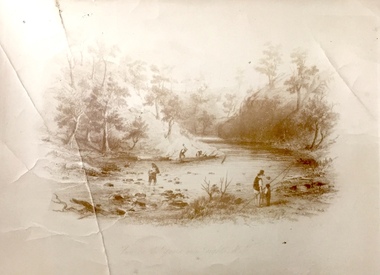
Print, View on the Yarra Near Dights Falls, Nineteenth Century
The original book plate reflects the colonial use of the River Yarra fro both recreation and industry.View on the Yarra Near Dights Falls. Reproduction of a book plate from an original wood engravingg, showing men and boys on the banks of the River Yarra. The activities represented include logging and fishing. Annotation on reverse: [Original] "Caption: View on the Yarra Near Dights Falls."yarra river, dights falls -
 Kew Historical Society Inc
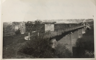
Photograph, Railway Viaduct, c.1919
The railway viaduct linking Kew and Fairfield was created for the Outer Circle railway.Railway viaduct, Yarra River, linking Kew and Fairfield. Built by John Monash for the Outer Circle Railway. In 1930 converted into the Chandler Highway Bridge for vehicular traffic. The point-of-view of the photograph shows Kew in the distance. Annotations on reverse: "Outer Circle Railway Bridge (now Chandler Highway) Fairfield-Kew, about 1919. Property of Miss Foley.outer circle railway, railway viaduct (kew), john monash -
 Kew Historical Society Inc
Photograph, Railway Viaduct, c.1900
Railway viaduct, Yarra River, linking Kew and Fairfield. Built by John Monash for the Outer Circle Railway. In 1930 converted into the Chandler Highway Bridge for vehicular traffic. Annotations on reverse: "KH-71. Outer Circle Railway Bridge (over Yarra) looking from Kew side to site of Paper Mills, Alphington.outer circle railway, railway viaduct (kew), john monash, chandler highway bridge -
 Kew Historical Society Inc
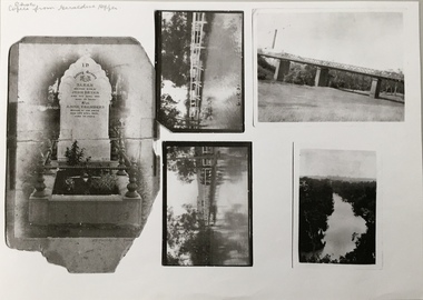
Photograph - Photocopy, Bryan Family Album, Twentieth Century
The Bryan family live din Princess Street, Kew.Photocopies of original photographs relating to or that belonged to the Bryan Family of Princess Street, Kew. The images include the headstone of Sarah Bryan and Anne Chambers; three photos of floods in Kew, one dated 1931; and a view of the River Yarra. bryan family (kew), kew -
 Kew Historical Society Inc
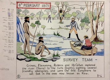
Work on paper, Joy Stewart, 1. Survey Team, 1988
Kew Tapestry. The eight panels depict the history of Kew. This was a 1988 Australian Bi-Centennial Project carried out under the auspices of City of Kew Council and the Kew Historical Society Incorporated. Nearly 600 citizens including many children participated in the production by adding a few or more stitches. A book records their names and the panels upon which they worked. Artist: Joy Stewart Co-ordinator: Dorothy BenyeiSydney Joy (Joy) Stewart was born in Melbourne 1925. She studied at Swinburne Technical College Art School from 1941-1945, then the National Gallery Art School 1946-1948. Her career included employment positions as a display artist, designer/painter, gallery assistant, and art teacher. Joy relocated to Cairns in 1981. Solo exhibitions in Melbourne and Cairns, including 'Done By Me' at Cairns Regional Gallery in 1999. Group exhibitions at Cairns Regional Gallery, 'The Fish John West Regrets, 1993' and 'Facets of Life' 1994. Joy Stewart died in Cairns in 2018.1. Survey Team. A Handcoloured cartoon created by the artist Joy Stewart as a template for the first of a series of embroidered panels depicting the history of Kew. Wool colour codes at left. Inscription: "8th February 1803. SURVEY. Grimes, Flemming (sic), Robbins and McCallum explored the river (Yarra) to the falls (Dights), sighting several friendly aborigines, and were the first Europeans to set foot in the area now known as Kew". Signed by the artist "(c) JStewart, 1988"bicentennial project (kew), joy stewart -
 Kew Historical Society Inc
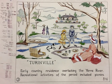
Work on paper, Joy Stewart, 2. Turinville, 1988
Kew Tapestry The eight panels depict the history of Kew. This was a 1988 Australian Bi-Centennial Project carried out under the auspices of City of Kew Council and the Kew Historical Society Incorporated. Nearly 600 citizens including many children participated in the production by adding a few or more stitches. A book records their names and the panels upon which they worked. Artist: Joy Stewart Co-ordinator: Dorothy BenyeiSydney Joy (Joy) Stewart was born in Melbourne 1925. She studied at Swinburne Technical College Art School from 1941-1945, then the National Gallery Art School 1946-1948. Her career included employment positions as a display artist, designer/painter, gallery assistant, and art teacher. Joy relocated to Cairns in 1981. Solo exhibitions in Melbourne and Cairns, including 'Done By Me' at Cairns Regional Gallery in 1999. Group exhibitions at Cairns Regional Gallery, 'The Fish John West Regrets, 1993' and 'Facets of Life' 1994. Joy Stewart died in Cairns in 2018.2. Turinville. A Handcoloured cartoon created by the artist Joy Stewart as a template for the second of a series of embroidered panels depicting the history of Kew. Wool colour codes at left. Inscription: "TURINVILLE. Early country residence overlooking the Yarra River. Recreational activities of the period included picnics." Signed by the artist "(c) JStewart, 1988"bicentennial project (kew), turinville, joy stewart -
 Kew Historical Society Inc
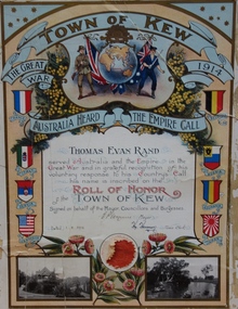
Certificate, Town of Kew, Thomas Evan Rand : Roll of Honor of the Town of Kew, 1918
Thomas Evan Rand was born at Hawthorn. He enlisted for service during World War One as an almost 20 year old engineering student, serving with the Australian Flying Corps.A commemorative certificate documenting the war service of Thomas Evan Rand of ‘Urangeline’, Barkers Road, Kew. Thomas Rand was an engineering student when he enrolled as a private in the Australian Army. He embarked on HMAT Orsova A67 on 16 March 1916. He was enlisted in the No 1 Squadron, Flying Corps. The formal certificate records that ‘ Thomas Evan Rand served Australia and the Empire in the Great War and in grateful recognition of his voluntary response to his Country’s Call his name is inscribed on the Roll of Honor of the Town of Kew’. The then Mayor and Town Clerk signed the certificate. [Kew did not become a ‘City’ until 1921]. The certificate highlights emblems and symbols of Australia and Great Britain, and includes the coats of arms of the allies in the war. The certificate is customised with two black and white photographs of Kew: the rotunda in the Alexandra Gardens at left, and boating on the Yarra River at right.Thomas Evan Rand served Australia and the Empire in the Great War and in grateful recognition of his voluntary response to his Country's Call his name is recorded on the Roll of Honor Town of Kew on behalf of the Mayor, Councillors and Burgesses. 1.8.18. E.P. Wynne [Mayor] H. Harrison [Town Clerk]roll of honor (kew), thomas evan rand, world war one, thomas rand, urangeline, kew, australian flying corps, alexandra gardens, wwi, yarra river -
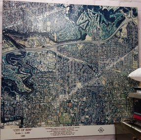 Kew Historical Society Inc
Photograph - Aerial Photograph, Division of Survey and Mapping, Department of Property and Services, City of Kew, Scale 1 : 3,000, 1989, 1989
The City of Kew was a local government area about 4 kilometres east of Melbourne, the state capital of Victoria, Australia, on the southeast bank of the Yarra River. The city covered an area of 14.56 square kilometres, and existed from 1860 until 1994.Very large aerial photograph of “City of Kew” Scale 1 : 3,000. 1989. “City of Kew” Scale 1 : 3,000. 1989. Photomosaic compiled by Division of Survey and Mapping, Department of Property and Services. © Crown (State of Victoria) Copyright 1990.city of kew, kew (vic.), aerial photography -
 Kew Historical Society Inc
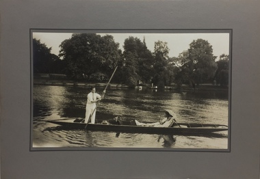
Photograph - John Duncan Brownlee and friends, Yarra River, The Artorium, 1920s
This mounted and framed photograph of a group of friends punting on the River Yarra has a number of historic and artistic associations. The photograph is primarily important as an informal photograph of the Australian baritone John Donald Mackenzie Brownlee (1900-1969), whose international career at the world's major opera houses from 1927 until his retirement in 1958 included singing at Melba's Covent Garden farewell in 1926, to recordings in the 1930s of a major series of Mozart operas in Glyndebourne Festival productions, conducted by Fritz Busch. Brownlee, born in Geelong, won the gold medal as champion vocalist at the South Street competitions in Ballarat in 1921. Moving to Paris in 1923 he began study with the French baritone, Dinh Gilly, making his operatic debut at the Trianon Lyrique in Montmartre in 1926. The most significant periods of his operatic career were with the Paris Opera from 1927 to 1936, and at the Metropolitan Opera from 1937 to 1957. After his move to Paris in 1923, he is recorded as revisiting Australia in 1928 as a member of the Melba-Williamson Company, and 24 years later in 1952. The photograph of Brownlee and the Gardners in a punt on the Yarra, while putatively dated to 1925, must be from earlier in the 1920s before his move to Paris, or later during the Melba-Williamson Company season. Before his move to Paris in 1923, Brownlee had lived in Belmont Avenue, Kew, where he must have developed a friendship with the Gardners. The photograph has additional artistic significance as it was produced at 'The Artorium', James Beament's design studio next to the Hawthorn Town Hall at 362 Burwood Road. With a home at 33 Uvadale Road (designed by Eric Nicholls, who managed the architectural practice of Walter Burley and Marion Mahony Grifffin from 1924 to 1932), Beament painted a number of significant murals for the Griffin practice, including those at the Capitol Theatre in Melbourne.A photograph of recreational activities on the River Yarra. The photograph is historically significant as a professionally produced photograph of the Australian operatic baritone John Brownlee, either before his move to Paris in 1923, or in 1928 during the Melba-Williamson Company operatic tour of Australia. The photograph has additional aesthetic significance as it was produced in James Beament's Hawthorn Studio - The Artorium - at 362 Burwood Road, next to the Hawthorn Town Hall.Framed photograph of John Duncan Brownlee, the Australian tenor, with Enid Gardner and friend in a punt on the Yarra River. Brownlee was born in Geelong but before his move to Paris in 1923, he lived for a period in Belmont Avenue, Kew. Three labels on reverse. 1. "John Duncan Brownlee, Operatic Star, originally of Geelong later resident of Kew at Belmont Av, on the pole. Also in the punt - Edith Gardner a friend. The Gardners lived on the east corner of Edgevale Rd. & Cotham. Approx. 1925." 2. "This picture is the property of Kew Historical Society 1/4/79". 3. Tel. Hawthorn 842 THE ARTORIUM ...."john brownlee (tenor), punting, recreation - yarra river (kew), james beament, the artorium -- 362 burwood road -- hawthorn (vic.) -
 Kew Historical Society Inc
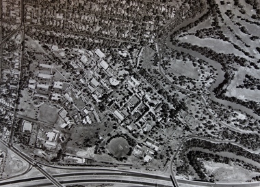
Photograph - Aerial Photograph, Aerial Photograph of Willsmere, circa 1980, c. 1980
This aerial photograph shows the Kew Cottages, and doctors/clergy residences on the north side of Wills Street, before the State Government sold the land for residential development. The doctors residences in Wills street were made of 'Glen Iris' Olympic Bricks. According to neighbours of the time most of the buildings were demolished overnight in the 1980s.Aerial photograph of Willsmere and the Kew Cottages bounded by the Boulevard, the Chandler Highway, Princess Street and Fellows Street. The roundabout at the intersection of Princess Street, Wills Street, and Eglinton Street is at the top left. The Eastern Freeway is at the lower edge of the photograph.kew cottages, eastern freeway, willsmere, yarra river, aerial photographs -- kew (vic), kew boulevard, willsmere mental hospital, kew mental hospital, kew childrens cottages -
 Kew Historical Society Inc
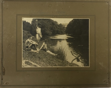
Photograph, Edwin Anderson, 1st Kew Scouts, Water Rescue Training, 1924
The 1st Kew Scouts was one of the first Scout Troops in Victoria, being formed in 1909. From 1927 they met in a magnificent Scout Hall in Disraeli Street, Kew until it was demolished in 1993. Still operating (in 2020) from their new Scout Hall on the corner of Kilby Road and Kellett Grove, Kew.1st Kew Scouts undertaking water rescue training at Bulleen. The photograph was most likely taken while the Scouts were camping beside the river one summer, with the programs generally including not only fun and games but also varying training activities. At the time many locals swam in the river. 1924 was well before the construction of major water storage dams and urbanisation of the upper reaches of the Yarra River, which significantly reduced downstream flows and water quality. These days, the Scouts tend to raft and canoe in the Yarra, rather than swim. On front: 1924. On reverse: photographer's stampscouts - kew, 1st kew scouts, yarra river, bulleen, water rescue training 1924 -
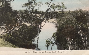 Kew Historical Society Inc
Postcard, The VSM.Series, No.351. River Yarra, Studley Park, Kew, Vic, c.1905
This is a colour postcard of the River Yarra at Studley Park, circa 1905. The postcard, which has handwritten notes on the reverse. It was printed in Prussia as part of the Victoria Stamp Market (VSM) Series. Coloured postcard of the Yarra River looking north from Galatea Point, near the Johnson Street Bridge.Donated by Miss B. Challen. ?Taken from bend above Galatea Point, looking north. Identified by Darcy Dugan, Yarra Bend Parks.river yarra, victoria stamp market (vsm) series, postcards -
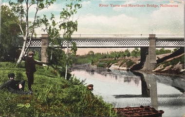 Kew Historical Society Inc
Postcard, Valentine's Series, River Yarra and Hawthorn Bridge, Melbourne, c.1907
... River Yarra and Hawthorn Bridge, Melbourne... distribution river yarra, railway bridge - hawthorn postcards ...Valentine's Series postcard, printed in Great Britain by Valentine’s Co. Ltd. (Valentine & Sons 1825-1963) for Australian distributionEarly postcard of the Hawthorn to Burnley Railway Bridge on the River Yarra. Station picnic on left. Tay Creggan on right. Buildings and location identified by Marshall Slattery in 1977. The postcard was printed in Great Britain and was published as one of Valentine's Series. "KH.87. Donated by Mrs B. Challen 2.2.76. Burnley to Hawthorn Railway Bridge. Station Picnic on left. "Tay Creggan" on right. Marshall Slattery 1977".river yarra, railway bridge - hawthorn, postcards -- hawthorn (vic.)