Showing 27615 items
matching yarra-river
-
 Kew Historical Society Inc
Photograph - Flooding of the Yarra Valley at Kew East, 1974
Flooding of the Yarra Valley, including that section of the Yarra bordering Kew and Kew East in the north and west of the municipality, was a regular occurrence. Extreme flood events of the Yarra River are recorded to have occurred in 1891, 1901, 1916, 1923 and 1934. The Municipality of Kew's response to these floods was to enact planning decisions restricting residential development in flood prone areas following the floods of 1916, 1921 and 1934. While floods continued after the development of the Upper Yarra Reservoir (construction 1948-57), the regularity and extent of these inundations diminished. During the nineteenth century, the land abutting the south side of the Yarra in Kew was devoted to dairy farming. In the twentieth century, before and after the construction of the Eastern Freeway, much of this low-lying area was used as golf courses and public parks.Late example of the capacity of the Yarra Valley at Kew to flood, even though drainage works and the Upper Yarra Reservoir had reduced their regularity.Original black and white print photograph of the low-lying land at East Kew under floodwater on 16 May 1974. The vantage point of the photographer is Lister Street. Flooding was caused by overflowing water in Glass' Creek and the River Yarra. Annotation verso: "Lister Street looking north / Flood level / 16 May 1974 11.30am / R.L. 46.04"hays paddock, floods, yarra river, glass' creek, lister street -
 Kew Historical Society Inc
Photograph - Flooding of the Yarra Valley at Kew East, 1974
Flooding of the Yarra Valley, including that section of the Yarra bordering Kew and Kew East in the north and west of the municipality, was a regular occurrence. Extreme flood events of the Yarra River are recorded to have occurred in 1891, 1901, 1916, 1923 and 1934. The Municipality of Kew's response to these floods was to enact planning decisions restricting residential development in flood prone areas following the floods of 1916, 1921 and 1934. While floods continued after the development of the Upper Yarra Reservoir (construction 1948-57), the regularity and extent of these inundations diminished. During the nineteenth century, the land abutting the south side of the Yarra in Kew was devoted to dairy farming. In the twentieth century, before and after the construction of the Eastern Freeway, much of this low-lying area was used as golf courses and public parks.Late example of the capacity of the Yarra Valley at Kew to flood, even though drainage works and the Upper Yarra Reservoir had reduced their regularity.Original black and white print photograph of the low-lying land at East Kew under floodwater on 16 May 1974. The vantage point of the photographer is Lister Street. Flooding was caused by overflowing water in Glass' Creek and the River Yarra. Annotation verso: "Lister St looking same as No.3 / 16 May 1974 11.30"floods, yarra river, glass' creek, lister street -
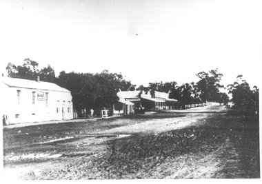
![Victorian Canoe Club: Pound bend tunnel [Warrandyte]](/media/collectors/550653872162f11fb04854aa/items/64e4a4b90e4970d244f1f6a1/item-media/64e4a4f30e4970d244f1fe96/item-fit-380x285.jpg) Kew Historical Society Inc
Kew Historical Society IncPhotograph - Victorian Canoe Club, Pound Bend Tunnel [Warrandyte], 1930–35
Canoeing on the River Yarra at Melbourne was an important and widespread recreational pursuit for Melbournians, especially in the first half of the twentieth century. The Victorian Canoe Club was formed in 1912 at a meeting in Melbourne and its first committee elected in the same year. Records indicate that the Club continued into at least the 1950s .The photos in this album are historically and socially significant as a record of recreational activities in the first half of the twentieth century. A number of photographs in the album provide views of sections of the Yarra, as well as areas in regional Victoria, that may otherwise be unavailable.One of 12 sepia [faded] photographs of members of the Victorian Canoe Club. This photo shows the mouth of the artificially made Pound Bend Tunnel, which was created to divert the course of the Yarra to enable gold prospecting in the river bed. "Pound Bend Tunnel"victorian canoe club, travel -- 1930s, canoeing, warrandyte, pound bend tunnel -
 Lorne Historical Society
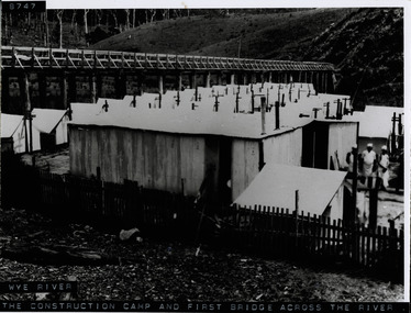
Photograph, Workers camp at Wye River Great Ocean Road
Photograph showing wooden bridge across Wye River, with workmen's camp below. Shows galvanized iron sheds, cooks standing outside huts, tents. Denuded hillside and dead trees. -
 Glenelg Shire Council Cultural Collection
Drawing, Kenneth Jack, Boatsheds on the Glenelg River, Nelson, Victoria, c. 1963
Drawing, pen and ink, black on ecru background, whit mount, black wooden frame, reflective glass, wire for hanging across width of frame on backFront: 'Kenneth Jack 1963' black ink (signature) 'BOATSHEDS ON GLENELG RIVER, NELSON' hand printed in black ink, bottom left corner -
 Melbourne Tram Museum
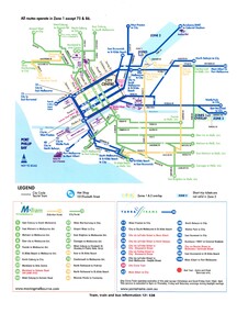
Map, VicTrip, Melbourne tram network - Yarra and M>Tram, 2000
Map - Colour print - of Melbourne's tram network, shows the lines operated by M>Tram or Yarra Trams, route numbers, ticket zones, zone overlaps and contact websites. - used in Fares and Travel Guide - 2000 and 2001 Map - see Reg Item 2508.trams, tramways, connex, map, melbourne, tramways, m>tram, yarra trams -
 Eltham District Historical Society Inc
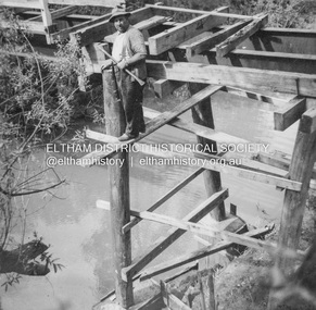
Album - Photograph, J.A. McDonald, General; Albion Street and Eltham-Yarra Glen Road, Oct. 1955
Eltham-Yarra Glen Road Lower Plenty Footbridge October 1955 (Jolly)Record of various Shire of Eltham infrastructure works undertaken during the period of 1952-1962 involving bridge and road reconstruction projects, sometimes with Eltham Shire Council Project Reference numbers quoted. It was during this period that a number of significant improvements were made to roads and new bridges constructed within the shire that remain in place as of present day (2022). In many situations, the photos provide a tangible visible record of infrastructure that existed throughout the early days of the Shire. The album was put together by or under the direction of the Shire Engineer, J.A. McDonald.infrastructure, road construction, shire of eltham, 1955-10, bridge construction, eltham-yarra glen road, lower plenty footbridge -
 Eltham District Historical Society Inc
Album - Photograph, J.A. McDonald, Irvine Crescent, Yarra Glen, Dec. 1952
December 1952 Being towed out backwards on Irvine Crescent, Yarra GlenRecord of various Shire of Eltham infrastructure works undertaken during the period of 1952-1962 involving bridge and road reconstruction projects, sometimes with Eltham Shire Council Project Reference numbers quoted. It was during this period that a number of significant improvements were made to roads and new bridges constructed within the shire that remain in place as of present day (2022). In many situations, the photos provide a tangible visible record of infrastructure that existed throughout the early days of the Shire. The album was put together by or under the direction of the Shire Engineer, J.A. McDonald.infrastructure, shire of eltham, bridge construction, road construction, 1952-12, irvine crescent, yarra glen -
 Greensborough Historical Society
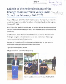
Document - Article, Rosie Bray, Launch of the redevelopment of the change rooms at Yarra Valley Swim School, 26/02/2021
Opening of the renovated change rooms at the Yarra Swim School, February 26th 20211 p.. two colour photographs, with separate prints of photographsyarra swim school, swimming pools greensborough -
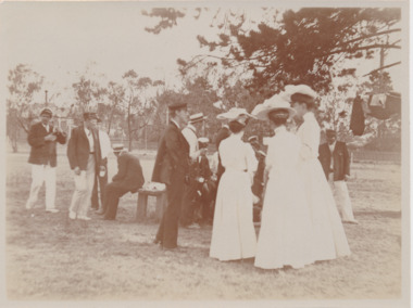 Mission to Seafarers Victoria
Photograph - Photograph, Sepia, Xmas day 1905, The Grammar School, Sth Yarra, 25 December 1905
Small gathering of seafarers and LHLG members, at grammar school, South Yarra, 1905Small monochrome photograph, depicting small informal gathering of men and women outdoorsHandwritten in pencil on verso: 12grammar, south yarra -
 Eltham District Historical Society Inc
Photograph, Coorie Bank, 410 Eltham Yarra-Glen Road, Kangaroo Ground, 5 Jun 1990, 5 June 1990
On the road to yarra glen past tower on right Home of Charis and Bill PellingRoll of 35mm colour negative film, 7 stripsFuji 200 Abuildings, houses, kangaroo ground, coorie bank, charis pelling -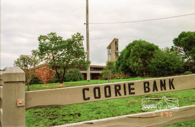
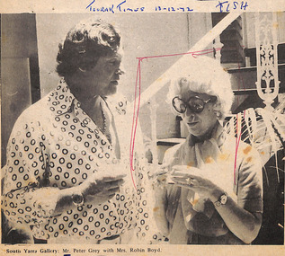 Robin Boyd Foundation
Newspaper - Clipping, Toorak Times, (South Yarra Gallery:...), 13/12/1972
Photo of Mr Peter Grey with Mrs Robin Boyd at South Yarra GalleryPublication details and TISH handwrittenmrs robin boyd, patricia boyd, peter grey, walsh st library -
![Outcasts, Mists and Shadows: a short history of institutional care around Yarra Bend, Melbourne / [by] Colin Briton](/media/collectors/550653872162f11fb04854aa/items/5ece5ebef36c2704c4f2a625/item-media/5ece5f9af36c2704c4f2a709/item-fit-380x285.jpg) Kew Historical Society Inc
Kew Historical Society IncBook, Colin Briton, Outcasts, Mists and Shadows: a short history of institutional care around Yarra Bend, Melbourne, 2019
History of institutional care in Yarra Bend Park and Studley Park by Colin Briton.[Northcote, Victoria] : Colin Briton, [2018] ©2018 v, 118 pages, 11 pages of plates : illustrations, maps ; 21 cm non-fictionHistory of institutional care in Yarra Bend Park and Studley Park by Colin Briton.institutional care -- victoria -- melbourne -- history., health facilities -- victoria -- melbourne -- history, asylums -- victoria -- melbourne -- history., reformatories for women -- victoria -- melbourne -- history. -
 Greensborough Historical Society
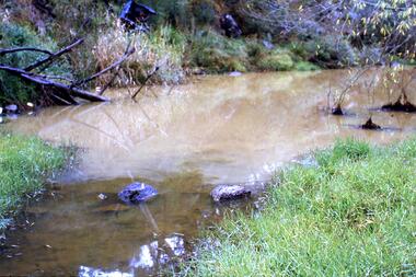
Slide - Photograph, John Ramsdale, Muddy Plenty River: Slide 93, 1990s
Photograph shows a muddy Plenty River with a small creek entering the river. Note the dumped car in background.Part of the John Ramsdale collection of slides and audio visual material.Colour photograph scanned from slide.No maker's marks. No caption on slide.plenty river, pollution -
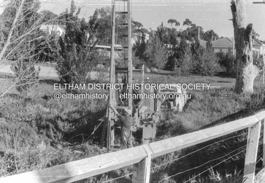
 Eltham District Historical Society Inc
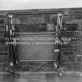
Negative - Photograph, J.A. McDonald, Upper Yarra Dam, 26 Nov. 1957
Upper Yarra Reservoir Opened by His Excellency The Governor of Victoria General Sir Dallas Brooks K.C.B.., K.C.M.G., K.C.V.O., D.S.O., K.St.J. On 26th November, 1957 This tablet also commemortyaes the centenary Of Melbourne's water supply system Yan Yean Reservoir 1857 Upper Yarra Reservoir 1957Record of various Shire of Eltham infrastructure works undertaken during the period of 1952-1962 involving bridge and road reconstruction projects, sometimes with Eltham Shire Council Project Reference numbers quoted. It was during this period that a number of significant improvements were made to roads and new bridges constructed within the shire that remain in place as of present day (2022). In many situations, the photos provide a tangible visible record of infrastructure that existed throughout the early days of the Shire. The album was put together by or under the direction of the Shire Engineer, J.A. McDonald.infrastructure, shire of eltham, 1957-11-26, opening ceremony, plaques, sir dallas brooks, upper yarra dam, upper yarra reservoir -
 Eltham District Historical Society Inc
Negative - Photograph, J.A. McDonald, Upper Yarra Dam, 26 Nov. 1957
Upper Yarra Reservoir Opened by His Excellency The Governor of Victoria General Sir Dallas Brooks K.C.B.., K.C.M.G., K.C.V.O., D.S.O., K.St.J. On 26th November, 1957 This tablet also commemortyaes the centenary Of Melbourne's water supply system Yan Yean Reservoir 1857 Upper Yarra Reservoir 1957Record of various Shire of Eltham infrastructure works undertaken during the period of 1952-1962 involving bridge and road reconstruction projects, sometimes with Eltham Shire Council Project Reference numbers quoted. It was during this period that a number of significant improvements were made to roads and new bridges constructed within the shire that remain in place as of present day (2022). In many situations, the photos provide a tangible visible record of infrastructure that existed throughout the early days of the Shire. The album was put together by or under the direction of the Shire Engineer, J.A. McDonald.infrastructure, shire of eltham, 1957-11-26, opening ceremony, plaques, upper yarra dam, upper yarra reservoir -
 Greensborough Historical Society
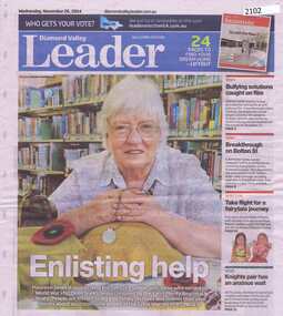
Newspaper clipping, Diamond Valley Leader, Enlisting help: stories honour Anzacs; with Yarra Plenty Regional Library flyer advertising Discover your Anzac story program, 26/11/2014
Research by Maureen Jones about Sgt. Reginald Simms and Nurse Elizabeth Gallagher as part of Yarra Plenty Regional Library publication program about people from Nillumbik, Banyule and Whittlesea who served in World War 1. Includes Yarra Plenty Regional Library flyer about the project.Front page colour image and article and image p. 5. Small colour flyer.world war 1, maureen jones, yarra plenty regional library, reginald simms, elizabeth gallagher -
 Greensborough Historical Society
Photograph - Digital Image, Marilyn Smith, Aqueduct crossing the Plenty River, Greensborough 2019, 02/07/2019
The aqueduct crossing the Plenty River, 2019, overgrown with vegetation. Originally part of the Maroondah Aqueduct pipeline, all that remains is the bridge that once carried the pipe over the Plenty River. This photograph was taken from the Plenty River Trail in Greensborough. 3 colour digital photographsplenty river trail, maroondah pipetrack, maroondah aqueduct, plenty river, graffiti -
 Greensborough Historical Society
Slide - Photograph, John Ramsdale, Plenty River: Slide 15, 1990s
Photograph shows the Plenty River with rubbish, including tyre and fallen branch. This part of the River is on the Montmorency - Greensborough border.Part of the John Ramsdale collection of slides and audio visual material.Colour photograph scanned from slide.No maker's marks. No caption on slide.plenty river, pollution -
 Eltham District Historical Society Inc
Album - Photograph, J.A. McDonald, Cecil Street Bridge, Eltham-Yarra Glen Road, Eltham, Oct. 1962
Eltham-Yarra Glen Road Cecil Street Bridge Looking upstream Oct. 1962Record of various Shire of Eltham infrastructure works undertaken during the period of 1952-1962 involving bridge and road reconstruction projects, sometimes with Eltham Shire Council Project Reference numbers quoted. It was during this period that a number of significant improvements were made to roads and new bridges constructed within the shire that remain in place as of present day (2022). In many situations, the photos provide a tangible visible record of infrastructure that existed throughout the early days of the Shire. The album was put together by or under the direction of the Shire Engineer, J.A. McDonald.H941 stamped on reverse (film processing #)infrastructure, shire of eltham, bridge construction, road construction, 1962-10, bible street reserve, cecil street bridge, eltham, eltham-yarra glen road, main road -
 Eltham District Historical Society Inc
Album - Photograph, J.A. McDonald, Cecil Street Bridge, Eltham-Yarra Glen Road, Eltham, Oct. 1962
Eltham-Yarra Glen Road Cecil Street Bridge Looking upstream Oct. 1962Record of various Shire of Eltham infrastructure works undertaken during the period of 1952-1962 involving bridge and road reconstruction projects, sometimes with Eltham Shire Council Project Reference numbers quoted. It was during this period that a number of significant improvements were made to roads and new bridges constructed within the shire that remain in place as of present day (2022). In many situations, the photos provide a tangible visible record of infrastructure that existed throughout the early days of the Shire. The album was put together by or under the direction of the Shire Engineer, J.A. McDonald.H941 stamped on reverse (film processing #)infrastructure, shire of eltham, bridge construction, road construction, 1962-10, cecil street bridge, eltham, eltham-yarra glen road, main road -
 Eltham District Historical Society Inc
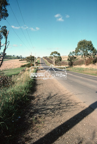
Negative - Photograph, J.A. McDonald, Eltham-Yarra Glen Road, Lower Plenty, c. July 1962
View looking west across Old Eltham Road to the Eltham-Yarra Glen RoadRecord of various Shire of Eltham infrastructure works undertaken during the period of 1952-1962 involving bridge and road reconstruction projects, sometimes with Eltham Shire Council Project Reference numbers quoted. It was during this period that a number of significant improvements were made to roads and new bridges constructed within the shire that remain in place as of present day (2022). In many situations, the photos provide a tangible visible record of infrastructure that existed throughout the early days of the Shire. The album was put together by or under the direction of the Shire Engineer, J.A. McDonald.1962-07, eltham-yarra glen road, infrastructure, lower plenty, lower plenty road, road construction, shire of eltham, old eltham road -
 Eltham District Historical Society Inc
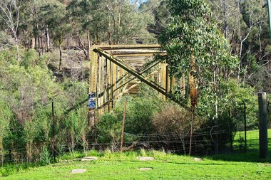
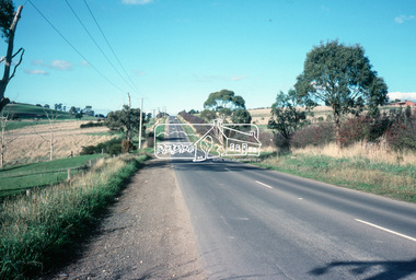
Slide - Photograph, Eltham-Yarra Glen Road, Kangaroo Ground, c.May 1988
Looking east along Eltham-Yarra Glen Road, Kangaroo Ground, c.May 198835mm colour positive transparency (1 of 36) Mount - Kodak KodachromeProcess Date MAY 88Minfrastructure, roads, eltham-yarra glen road, kangaroo ground -
 Eltham District Historical Society Inc
Slide - Photograph, Eltham-Yarra Glen Road, Kangaroo Ground, c.May 1988
Looking east along Eltham-Yarra Glen Road, Kangaroo Ground, c.May 198835mm colour positive transparency (1 of 36) Mount - Kodak KodachromeProcess Date MAY 88Minfrastructure, roads, eltham-yarra glen road, kangaroo ground -
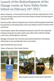 Greensborough Historical Society
Document - Report, Rosie Bray, Launch of the redevelopment of the change rooms at Yarra Valley Swim School 2021, 26/02/2021
Launch of the redeveloped change rooms at the Yarra Valley Swim School 26 February 20211 p. typescript and colour photographsyarra valley swim school, liat way greensborough, swimming pools greensborough -
 Eltham District Historical Society Inc
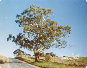
Photograph, Peter Bassett-Smith, White Gum, Main Road Eltham-Yarra Glen, Kangaroo Ground, June 1977, 1977
Colour photograph of a Eucalyptus Viminalis (White Gum or Ribbony Gum or Manna Gum) on Main Road, Eltham-Yarra Glen (Melways Directory Map 23 D1) looking west approximately 1 mile from Kangaroo Ground approx. opposite Andy Avard's gate.eltham yarra glen road, kangaroo ground -
 Tarnagulla History Archive
Photographs: Buildings in Newbridge near Loddon River bridge, Buildings in Newbridge near Loddon River bridge, 1908 (original image)
Depicts at left, Petersen's bakery, a store shed, Simpson's storekeepers and Simpson's Hotel. Hollands blacksmith shop & wheelwrights on right opposite bakery. Murray Comrie Collection. Three copies of a monochrome photograph, image depicts buildings in the eastern approach to the Loddon River bridge at Newbridge This is a fairly dark copy of an older original. Copy probably made by Murray Comrie in the 1960s.newbridge, loddon river, bridge, shops, stores, businesses, hotels, simpsons, petersens, bakery -
 Melbourne Tram Museum
Pamphlet, Yarra Trams, "Four years of achievement", 2008
Pamphlet - 7 fold full colour sheet printed on light card, titled 2004 - 2008, or "Four years of achievement" outlining the achievements of Yarra Trams for each year in that period. has photographs and text of events undertaken by Yarra Trams, signed by Dennis Cliche with a love your trams logo. Two copies held.trams, tramways, yarra trams, tram e -
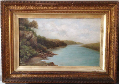 Warrnambool and District Historical Society Inc.
Painting, Hopkins River - Clifton Banks, Early 20th century
Clifton Banks is the name given to a bank on the Hopkins River Estuary, about one kilometre upstream from Proudfoots Boathouse. It is at the foot of the property, Clifton which dates from the 1850s. There are several works of art and photographs depicting Clifton Banks which date from the 19th and early 20th centuries. This oil painting is believed to be the work of Emma McGeorge, the wife of Canon Samuel McGeorge, the Vicar of Christ Church, Warrnambool form 1899 to 1905. It is surmised that Emma McGeorge was encouraged by the artist Mary Norman to take up painting as a pastime or to continue with her art interests. Emma McGeorge may have been a pupil of Samuel Pearce Fuller and Mary Norman. She was successful as an exhibitor and entrant in art exhibitions in Warrnambool in the early 1900s. She died in Warrnambool in 1933. This is a highly significant art work as it has artistic merit and is one of the depictions of Clifton Banks on the Hopkins River and so has historical value. It is an example of the high standard of art work that was being produced, especially by women, in the late 19th and early 20th centuries in Warrnambool. It was bought at an auction sale in Camperdown by Les O’Callaghan in 1997. This is an oil painting, probably by Emma McGeorge, on art board of Clifton Banks on the Hopkins River. It has a gilt wooden frame with multi-tiered highly-ornamented outer frames in a gold colouring. The lower frame is discoloured (perhaps by smoke from a fire place) and there is a small piece of wood missing on the lower frame. All the gilding is slightly discoloured. The back has been sealed with pasted paper and there are old tacks and old wire for hanging the picture. There is a label on the back from W. Hickford, the Warrnambool picture framer and handwritten information on the artist and the artwork by Les O’Callaghan.Front: ‘E.Mc.G.’ Back: ‘W. J. Hickford, Picture Dealer, Framer and Gilder, Liebig Street, Warrnambool, Mounting and Repairing, Old Frames Re-gilt, Oakley Printer’ ‘603’ clifton banks, emma mcgeorge, warrnambool, hopkins river estuary