Showing 10342 items
matching 1960-1964
-
 Flagstaff Hill Maritime Museum and Village
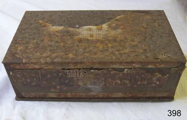
Container - Biscuit Tin, Swallow and Ariell Pty Ltd, Mid-19th to mid-20th century
This tin was made in Melbourne and contained Swallows and Ariells biscuits. The label was written in four languages. The biscuits may have been made for export or perhaps for immigrants now living in Australia. Australia's first biscuit company was founded in 1854 by Thomas Swallow. Within five years he had taken in a partner, T.H. Ariell. After Ariell died in 1875, F.T. Derham was appointed partner and managing director in 1877, a position held by several generations of his descendants. By the early 1880s the Port Melbourne factory extended to 3 acres (1.2 ha), and the company owned flourmills and sugar plantations in the Goulburn Valley and Northern Queensland. With no equal outside Great Britain, Swallow & Ariell was the fifth largest biscuit company in the world, manufacturing over 100 varieties, including the common ship biscuit (an original product) and meat biscuits (apparently taken by Burke and Wills on their ill-fated expedition). The company also boasted popular sideline products, including cakes, plum puddings, ice-cream and dried fruit. Renowned for its patriotic fundraising campaigns during both world wars, it diverted most of its biscuits and plum puddings to the Australian and US services in World War II. Company employees were filmed leaving work in 1905 in the Salvation Army film unit's first sponsored industrial documentary film. The surviving opening sequences are held by ScreenSound Australia. The company was delisted on 5 August 1964 following acquisition of more than 95% of its capital by the Australian Biscuit Co. The factory was later registered by the National Trust and converted into units. https://www.emelbourne.net.au/biogs/EM01456b.htmThis biscuit tin is representative of local Melbourne and Victorian produce. The label was in four languages, perhaps for export or for local immigrants. The firm Swallow and Ariells Pty Ltd was a very early manufacture and was in business for over 100 years.Rectangular tin container with attached lid. Label advertises Swallow and Ariells biscuits. Made in Melbourne. The label is written in four languages. The trademark, a swallow, is on the tin. The tin is very badly corroded.'Swallow and Ariells Superior Melbourne Biscuits' Trademark: image [swallow]flagstaff hill, warrnambool, shipwrecked-coast, flagstaff-hill, flagstaff-hill-maritime-museum, maritime-museum, shipwreck-coast, flagstaff-hill-maritime-village, metal craft, tin ware, biscuit box, biscuit tin, food container, melbourne biscuit maker, swallow, thomas swallow, thomas ariell, ariell -
 Bendigo Military Museum
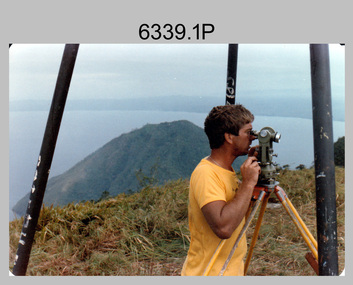
Photograph - Royal Australian Survey Corps personnel on survey operations in PNG and possibly Indonesia, c1975
This is a set of two photographs of Royal Australian Survey Corps and RAAF personnel on survey operations in PNG and possibly Indonesia circa 1975. The identified surveyor - Peter Presser served 20 years in the Australian Regular Army from 1970 to 1990. The UH-1H Iroquois helicopter (serial number partially obscured) appearing in photo 6339.2P was probably A2-379. From 1957 helicopter transport of survey parties revolutionised transport in remote areas. The most common helicopter used by the Royal Australian Survey Corps (RA Svy) up to 1972 was the civilian Bell 47G-2 and the Sioux Light Observation Helicopters (LOH), the Australian Army’s equivalent. These light observation helicopters had a limiting load carrying capacity of up to about 500 pounds. By comparison, one Aerodist team including two people weighed up to 1,500 pounds. After No. 9 Squadron (9SQN) RAAF (Iroquois helicopters) withdrew with the Australian force from Vietnam in December 1971, RAAF supported RA Svy operations with the UH-1H Iroquois helicopter for tasks of transport and resupply of survey teams. The UH-1H was capable of carrying at least three times that of the smaller Bell 47G-2/Sioux LOH helicopter and could also winch personnel and stores into difficult locations. A2-379 crashed killing the aircraft captain (FLTLT Ralph Taylor 9SQN) on impact and seriously injuring four near Wamena, Irian Jaya, Indonesia on survey Operation Cenderawasih 1977 (supporting 2 Fd Svy Sqn – Doppler satellite survey). Source: Royal Australian Survey Corps – Aerodist Years 1964-1975 by Peter Jensen.This is a set of two photographs of Royal Australian Survey Corps and RAAF personnel on survey operations in PNG and possibly Indonesia circa 1975. The photographs were printed on photographic paper and are part of the Army Survey Regiment’s Collection. The photographs were scanned at 300 dpi. .1) - Colour, black & white, c1975, Peter Presser undertaking survey observations in PNG with a Wild T2 Theodolite. .2) - Photo, black & white, c1975. Survey operations L to R: unidentified (x2), Peter Presser, unidentified. .1P and .2P – No annotations. royal australian survey corps, rasvy, army survey regiment, army svy regt, fortuna, asr -
 Ballarat Clarendon College
Medal
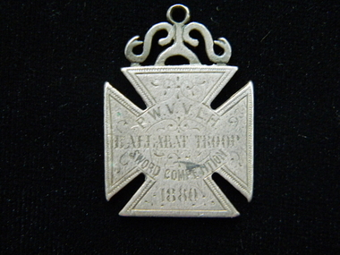
The medal was awarded to Trooper John Garbutt of the Prince of Wales Victorian Volunteer Light Horse (Ballarat) in 1880 for attaining fourth prize n the sword competition. In 1862, the units of the Mounted Volunteer Corps in Victoria were formed into a single regiment known as the Victorian Volunteer Light Horse. This title changed again in 1863, to the Prince of Wales Victorian Volunteer Light Horse ( Hussars ). In 1870 a uniform was adopted that was based on the British 19th Hussars. Troops were based at various times at Geelong, Ballarat, Kyneton, Bendigo, Castlemaine and Dandenong, as well as metropolitan Melbourne. In 1885, most of the Cavalry were incorporated into a newly formed Victorian Mounted Rifles. (http://www.awm.gov.au/collection/REL/18070.001) John Garbutt was Principal of Ballarat College 1877 - 1909. He was educated at Geelong National Grammar School and in 1860 was the first dux of the college. He was educated at Geelong National Grammar School and in 1860 was the first dux of the college. Fist class Honourman Arts and Laws at Melbourne University 1866; Two years a master at Geelong College; seven years master and three years senior master at Scotch College, Melbourne. Mein's 1964 History of Ballarat College states: 'To summarise, it may be fairly claimed that the College's War Record in 1914-1918 would have reflected great credit on a school with ten times its numbers...Some of the credit of the college war record must be attributed to the influence of Major John Garbutt, M.A. who was Principal of the College for 33 years...Nearly all the old Collegians who distinguished themselves in the war had been trained by him. Silver coloured maltese cross medal with decorative link attached to top and engraved on both sides. The medal was awarded to Trooper Whyte of the Prince of Wales Victorian Volunteer Light Horse (Ballarat) in 1877. Face: P.W.V.V.L.H. / BALLARAT TROOP / SWORD COMPETITION / 1880 Verso: 4th PRIZE / Trooper garbutt ballarat-college, principal-john-garbutt, prince of wales victorian volunteer light horse, medal, 1880, principal -
 Flagstaff Hill Maritime Museum and Village
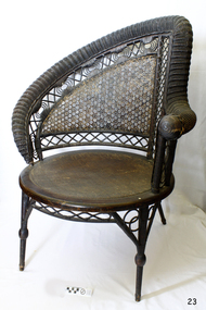
Furniture - Chair, 1855-1900
Heywood & Wakefield Furniture Co: The Heywood-Wakefield Company is an American furniture manufacturer established in 1897 that went on to become a major presence in the US. Its older products are considered collectibles and have been featured on television antique programs. The Heywood brothers established themselves in 1826, as furniture makers and the Wakefield Company began in 1855 as a separate company. Both firms produced wicker and rattan furniture, and as these products became increasingly popular towards the end of the century, they became serious rivals. In 1897 the companies merged as Heywood Brothers & Wakefield Company (this name was changed to Heywood-Wakefield Company in 1921), purchasing Washburn-Heywood Chair Company in 1916, Oregon Chair Company in 1920, and Lloyd Manufacturing Company in 1921. While its wooden furniture plant in Gardner, Massachusetts closed in 1979, a branch in Menominee, Michigan continued to manufacture metal outdoor seats, auditorium seats, and school furniture. The Heywood-Wakefield Company Complex in Gardner was added to the National Historic Register in 1983. The South Beach Furniture Company acquired the rights to the name in 1994 and reproduces its wooden furniture. Both founding companies produced wicker and rattan furniture in the late 19th century. The wicker styles drew on the Aesthetic Movement and Japanese influences simpler designs arose in the wake of the Arts and Crafts Movement. The merged entity stayed abreast of wicker furniture trends by hiring designers such as Paul Frankl and Donald Deskey during the 1920s. Its furniture was exhibited at the 1933 Century of Progress exhibition and the 1964 New York World's Fair. During the 1930s and 1940s, Heywood-Wakefield began producing furniture using sleek designs based on French Art Deco.The chair has social significance at a local level, because it illustrates the level of material support the Warrnambool community gave to Flagstaff Hill when the village and Museum was established. The wicker nursing chair is a fine example of late 19th century light weight domestic furniture that today are very collectible items and quite rare and valuable.Nurse wicker chair, wood, cane and rattan with round rushed seat. The one left arm being that to support the infant during feeding. 1870s-1890s. Believed to have been made by Heywood Brothers & Wakefield Company, USA. flagstaff hill, warrnambool, flagstaff hill maritime museum, shipwreck coast, great ocean road, 19th century furniture, rolled serpentine wicker work, cane armchair, classic wicker furniture, victorian style furniture, domestic furniture late 19th century, heywood-wakefield company, feeding chair, nursing chair, mother's chair, nursery furniture -
 Surrey Hills Historical Society Collection
Photograph - Mont Albert Primary School, 1926
This was reproduced from a copy of the 1926 flyer relating to the Annual Speech Night. See vertical file re Mont Albert Primary / Mont Albert Central School. It was reproduced with the consent of the school archives in the early 1980's by Kenneth Tudor Hall. Mont Albert Primary was built in 1917 and was designated as a Central School in 1918 when Forms 1 & 2 were added. It remained as such until the 1964 when the secondary years formed the basis of a new high school, known as the Box Hill North High School, (later changed to Koonung Secondary College). The original building was constructed of solid red brick and consisted of seven rooms. In May 1924 a further four rooms, also in red brick, were added. The school opened with an initial enrolment of 147 students in Prep to Grade 6. A further 72 children were admitted during the year, making a total enrolment in the first year of 219. The land facing Kenmare Street was purchased in 1919, adding another 2 acres to the 5.5 acres which the school occupied in 1917. The first Principal was Charles Hyland, who was assisted by three teachers. The first official meeting of the School Council in May 1917 reveals that the building was in some senses a shell, requiring additional input from parents. Mention is made of the need for asphalting of playing areas, providing a letter box and electric lights for the lobby, double room, office and sewing room. Mont Albert was the first School in Victoria to have the interior purely constructed of Victoria hardwood, from floor to ceiling. An Honour Board was erected in 1919. mont albert central school, mont albert primary school, mont albert, schools -
 Vision Australia
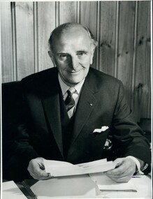
Photograph - Image, Howard Murray (Pat) Lightfoot, 1969
Howard Murray (Pat) Lightfoot (1904-1991) served as President for the Association for the Blind in 1952-1954 and 1964-1972 respectively. He joined the Association in 1938 as a sighted member of the General Committee, and was part of the group that dealt with the breakdown of a uneasy financial agreement that existed between the RVIB and AAB, the incorporation of the AAB under the Charities Act and the development of a rehabilitation centre at Kooyong for those who wished to have support without a residential component. After losing his father at an early age, Pat Lightfoot began working as an office boy for Nicholas Pty Ltd, later studying and becoming an accountant - such skills highly needed by the newly incorporated Association. According to 'No Sight, Great Vision', he was a highly skilled communicator, whose friendly and approachable manner won over most of those who opposed his presence on the general committee due to his sight. His support for and recognition of the work done by Mr Paterson led to him standing aside for the position of President and nominating his friend until the Committee overrode him in 1952. His appointment signaled a change in how the organisation was run, and introduced John Wilson as Secretary as well as Stan Horsfall as Treasurer in 1953, which helped move the administration style from social volunteering to business thinking. Health concerns caused him to resign in 1954, however when his health improved he rejoined the Committee in 1958 and again became a key worker in keeping the organisation financially healthy. The "H.M. Lightfoot Centre" - a two storey building attached to Paterson Hall was named after him. This image was provided when J Balmain was approached to paint a portrait of Mr Lightfoot, for the centenary celebrations of the AFB, as per the letter.1 portrait photograph of Howard (Pat) Lightfoot and 1 associated letter regarding usage for a portrait by Balmain.Mr H.M. (Pat) Lightfoot - (Past President) 1" Deep (No. 2) Association for the Blind 7 Mair Street Brighton Beach, 3188 Please return to PR Department (arrow pointing to left) 14 ems (arrow pointing to right) 1.95 .1 100# Ticket No: 5230 Client: Abaris 100# Wanted: Tues 19th AM Mounted: as layout and sticker 43 1/4% Please Quote No: BA 9105 Laurie Richards 4 Tower Ave, Alphington 3078 489-8528 48-5541h.m. lightfoot, association for the advancement of the blind, association for the blind -
 Vision Australia
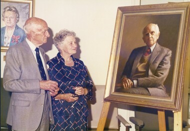
Photograph - Image, Pat and Beth Lightfoot, 1985
Howard Murray (Pat) Lightfoot (1904-1991) served as President for the Association for the Blind in 1952-1954 and 1964-1972 respectively. He joined the Association in 1938 as a sighted member of the General Committee, and was part of the group that dealt with the breakdown of a uneasy financial agreement that existed between the RVIB and AAB, the incorporation of the AAB under the Charities Act and the development of a rehabilitation centre at Kooyong for those who wished to have support without a residential component. After losing his father at an early age, Pat Lightfoot began working as an office boy for Nicholas Pty Ltd, later studying and becoming an accountant - such skills highly needed by the newly incorporated Association. According to 'No Sight, Great Vision', he was a highly skilled communicator, whose friendly and approachable manner won over most of those who opposed his presence on the general committee due to his sight. His support for and recognition of the work done by Mr Paterson led to him standing aside for the position of President and nominating his friend until the Committee overrode him in 1952. His appointment signaled a change in how the organisation was run, and introduced John Wilson as Secretary as well as Stan Horsfall as Treasurer in 1953, which helped move the administration style from social volunteering to business thinking. Health concerns caused him to resign in 1954, however when his health improved he rejoined the Committee in 1958 and again became a key worker in keeping the organisation financially healthy. The "H.M. Lightfoot Centre" - a two storey building attached to Paterson Hall was named after him. In these three photographs Pat and his wife Beth look or stand next to the portrait painted of Pat Lightfoot, for the centenary celebrations.3 coloured photographs of Pat and Beth Lightfooth.m. lightfoot, association for the blind -
 Wodonga & District Historical Society Inc
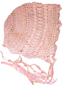
Mixed media - Crocheted Baby Bonnet
This bonnet was made to be worn by Patricia Kathleen Grant. She was born in1925, the daughter of Dr Frank John Audas Grant and Kathleen Josephine Dixon. Dr Frank Grant gave many years of service to the Wodonga community both as its doctor and on several community organisations and committees. He was born in South Yarra, Victoria in 1897 and after finishing school he began Medical Studies at Melbourne University. In 1915 he enlisted in the Australian Army and was assigned to the Hospital Transport Corps and later with the 8th Field Artillery Brigade aboard HMAT Medic. He was wounded in action with gunshot wounds to the arm and back. After time in hospital in England, Frank was returned to Melbourne where he was discharged as medically unfit on 24th October 1917. During World War II Dr Frank Grant served as an Honorary Captain in the Australian Army Medical Corps. His records show that he was accidentally “Mustard Gassed” at Bandiana. Dr Frank Grant commenced practice in Wodonga in 1923, entering into a partnership with Dr Rudolph Schlink. This marked the beginning of a long career dedicated to the Wodonga community. By 11 August 1926 he held the role of Public Vaccinator with the Commission of Public Health in Wodonga. Apart from long years of dedication to health in Wodonga, Dr Grant also took on numerous roles within Wodonga. This included being a Commissioner of the Wodonga Waterworks Trust from 6 April 1932 until 29 July 1963. He was a strong advocate for the development of the Wodonga Base Hospital which opened in 1954. Doctor Grant passed away on 14 January 1964.This item is significant because it is representative of crocheted handcraftsA small hand crocheted baby's bonnet made of silk cotton thread and lined with silk. A silk ribbon is attached.crocheted items, dr frank grant, handcraft -
 City of Moorabbin Historical Society (Operating the Box Cottage Museum)
Newsletter - CMHS Moorabbin Mirror Vol 6 April 2016, Moorabbin Mirror Vol 6 April 2016, April 2016
This is Vol. 6 of the Moorabbin Mirror produced by CMHS members Fran & Holger Bader , Valma Sharp April 2016 The Moorabbin Mirror reflects the history and heritage of the former City of Moorabbin — derived from Mooroobin, ‘a resting place’ in the Bunurrung spoken language. In 1994, the City of Moorabbin was integrated into the Cities of Bayside, Glen Eira, Kingston and Monash. This issue of the Moorabbin Mirror is dedicated to all the young, and not so young, men and women from the former City of Moorabbin who served ‘King and Country’ during the Great War. Especially those who never came home including a photo of WW1 Mordialloc Memorial and the 2016 Local Commemorative Services. Valma Sharp CMHS President 'officially opened' the new WC and thanked GECC for this amenity. Members and Guests then shared light refreshments before welcoming visitors to the BCM Extra Open Day. Unfortunately Lorna Thatcher was unable to attend due to a sudden illness and Committee and members sent Get Well wishes via Frank. The Diary informs members of the Extra Open Days, upcoming publicity events , Meetings and Community Group visits to BCM, Local interest items include Lees Nursery, Market Gardening Heritage, Westall UFO, Joyce Park Playground Solar System., Moorabbin Ten Pin Bowl and the School Amateur Radio Special Event. The Committee is very grateful for the help provided by David Hardham GEHS to set up our new CMHS website. An informative article re the 2012 GESAC that replaced the 1964 Olympic Pool. Information is requested for the Roving Curator August Rietman display 2017.This is Vol. 6 of the Moorabbin Mirror, Newsletter of CMHS April 2016A4 x 3 paper folded to A5 x 6pp with colour photographs. Moorabbin / Mirror / April 2016 Vol 6moorabbin mirror, bader fran, bader holger, sharp valma, hardham david, thatcher lorna, anzac memorial mordialloc, anzac, lees nursery thomas st brighton east, gesac, moorabbin ten pin bowling, joyce park playground ormond, bentleigh, moorabbin, mckinnon, roving curator program mav, westall ufo, -
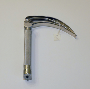 Geoffrey Kaye Museum of Anaesthetic History
Tool - Laryngoscope, Macintosh
A laryngoscope is an instrument used to view the larynx (voice box), which is the opening to the trachea and lungs. It consists of a “blade,” which goes into the patient’s mouth, and a handle. Prior to 1943 when Macintosh introduced his curved blade, most laryngoscope blades were long and straight. The straight blades were used to directly hold the epiglottis. Macintosh’s curved blade works differently: it indirectly opens the epiglottis by applying pressure to a space between the root of the tongue and epiglottis, called the vallecula. The flange running along the left lower edge of Macintosh’s blade was also a novel innovation. It was designed to move the tongue to the side, which improved the view of the larynx and made more room for a breathing tube. The Macintosh Laryngoscope remains one of the most popular blades worldwide. (Source: Wood Library Museum) This laryngoscope was previously owned by John Mainland, as evidenced by the name etched into the handle. Mainland graduated from the University of Melbourne in 1950 with a Bachelor of Science degree. After researching and completing his medical degree, Mainland entered into the field of anaesthetics, training at the Royal Women's and Royal Children's Hospitals, later Alfred Hospital, in 1959. He completed training in 1964 and remained at the Alfred Hospital. During his career, he also became the first anaesthetist appointed to the position of Professor in Victoria. His other achievements include manufacturing a respiratory monitoring module that accompanied astronauts on the United States moon landing and developing a stimulator to lessen the risk of deep vein thrombosis in surgical patients. Mainland became a Fellow of the Australian and New Zealand College of Anaesthetists in 1992, retiring from the profession in 1997.Oblong shaped handle with textured grip. Attached is a laryngoscope blade in a cruved shaped with light tube running through one side.Etched into top of handle: J.F. MAINLAND •Stamped into top of handle: REGD TRADE MARK / PENLON / MADE IN ENGLAND •Stamped into base of handle: CLOSE [arrow] •Etched into base of blade: MAC / 4 •Stamped into side of blade: REGD TRADE MARK / PENLON / MADE IN ENGLAND •Stamped into side of blade: STAINLESSmacintosh, robert reynolds, new zealand, laryngoscope, mainland, john, alfred hospital, moon landing -
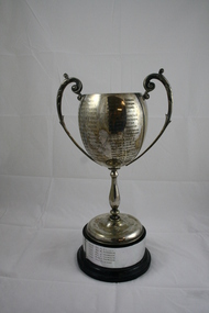 Emerald Museum & Nobelius Heritage Park
Golf Trophy
Emerald Country Club Associates Ladies Championship Trophy from 1937 to 1996Local golf club trophy donated by ex committee member Rosalie LeakeSilver Golf Trophy Cup (Ladies) on wooden base.. engraved with winners from 1937 to 1996 Emerald Country Club Associates E.M..KENNON CUP 1937 Mrs G.L. Elkins 1938 Mrs T.W. Gunnersen 1939 Mrs Norman 1940 Mrs A. Baker 1946 Mrs L.A. Fenton 1947 Mrs A.L. Newold 1948 Mrs C. Bedgood 1949 Mrs A. Baker 1950 Miss P. Massey 1951 Mrs W.H. Symon 1952 Mrs W.H. Symon 1953 Mrs A.L. Newbold 1954 Mrs W.H. Symon 1955 Miss M. Jamison 1956 Mrs W.H. Symon 1957 Miss J. Mellor 1958 Mrs L. Bulmer 1959 Mrs W.H. Symon 1960 Miss J. Mellor 1961 Mrs E. Hoy 1962 Mrs L. Bulmer 1963 Miss D. Smith 1964 Mrs N. Tuxen 1965 Mrs M. Hanger 1966 Mrs A. Howard 1967 Mrs R. Morgan 1968 Mrs P. Young 1969 Mrs J. Little 1970 Mrs J. Fountain 1971 Miss P. Jackson 1972 Mrs J. Little 1973 Mrs J. Houghton 1974 Mrs J. Meldrum 1975 Mrs. B. Barraclough 1976 Mrs J. Meldrum 1977 Mrs F. Gooch 1978 Mrs S. Hunter 1979 Ms F. Fenton 1980 Mrs J. Martin 1981 Mrs C. Grand-Court 1982 Mrs J. Pugh 1983 Mrs M. Ruigrok 1984 Mrs P. Summers 1985 Miss A. Scurry 1986 Mrs P. White 1987 Mrs M. Ruigrok 1988 Mrs P. White 1989 J. Ross 1990 Miss B. Bates 1991 Ms A. Felgate 1992 Ms M. Purbrick 1993 Ms J. Thomson 1994 Ms J Tomson 1995 Ms J Thomson 1996 Mrs R. Leake emerald country club, wm kennon cup, golf trophy 1937 to 1996 -
 Department of Health and Human Services
Photograph, Berry Street Kindergarten
In 1877 the Victorian Infant Asylum was founded in Kew. In 1881, the asylum relocated to Berry Street in East Melbourne. By 1908, it was called the Foundling Hospital and Infants Home. It was non-denominational and controlled by a committee of management. By 1956, Berry Street consisted of a Mothercraft Training Centre and two main residential units: Berry Street for infants aged zero to 18 months, and Vale Street for toddlers aged zero to two years old. In August 1956, Berry Street was declared an approved category 2 Children's Home. In 1960, Vale Street was converted to an adult nursing home. In 1964, the name was changed to Berry Street Babies Home and Hospital. Berry Street was also an approved adoption agency. By 1968, Berry Street comprised the Training School for Mothercraft Nurses, the adoption agency, an infant life-protection house, a long-stay home for children to three years of age (the toddlers’ wing) and a small house for unmarried mothers. The home's infant life-protection work was seen as a critical agency function, particularly where family illness was putting pressure on mothers and Berry Street was able to provide respite and support. By the late 1960s, 30–40 adoptions annually were being arranged from Berry Street. By 1974 the home's orientation had shifted. Four family group homes had been established (two in Burwood, one in Ashburton and one in St Kilda), the mothercraft training function had been phased out, the toddlers wing converted to day care, and the main building (containing the nursery, administration, kitchen, dining room and single mothers accommodation) was demolished in favour of four home units, which housed 24 children, supervised by cottage parents. Berry Street provided short term, emergency and residential care for 'protection of infant' cases and state wards. Two flats were also established for short-term family accommodation. The nurses’ home was converted to house the home’s administration function and a social work service. The social work service coordinated family aid and family counselling services, and a neighbourhood house. In 1975 Berry Street also provided short-term care for 42 Vietnamese children brought to Australia in the official government-sponsored airlift. In 1976 Berry Street made application to change its category 2 Children's Home classification to category 1, as it was now catering for a wider range of children. It had ceased to be a babies’ home and hospital, and had started providing child and family care, including residential care. In 1977 Berry Street to established a family group home in Richmond to house children affected by the closure of St Cuthbert's Children's Home in Colac. Berry Street changed its name to Berry Street Child and Family Care in 1977. In 1978, the range of services provided by Berry Street Child and Family Care consisted of a social work counselling service, a financial aide, a family aide program using volunteers, two temporary accommodation units each housing eight children, an information and referral service, a neighbourhood house in Richmond, a day care centre for 36 children, and four family group homes. In 1980–81 the family group homes in Burwood were sold and the resources moved to the Richmond area. In 1994, Sutherland Youth and Family Services Inc. amalgamated into Berry Street Inc. During the 1990s, Berry Street combined with the Sutherland Community Resource Centre in Watsonia in Melbourne’s northern region. The agency operates today as Berry Street Victoria and has service centres across metropolitan and country Victoria. https://www.findingrecords.dhhs.vic.gov.au/CollectionResultsPage/BerryStreet -
 Flagstaff Hill Maritime Museum and Village
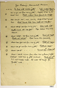
Document - Report, Jet Probings, Warrnambool Harbour, 16-10-1929
This report lists the depths of water and the consistency of the seabed surrounding the Warrnambool Harbour in October 1929, The information, often referred to as 'soundings', was obtained by Jet Probing,. In earlier days a lead line was used to perform a similar task. The author of the document is unknown. Jet Probing is a method used for underwater archaeology, cable installation and coastal engineering. A jet probe is a machine that produces a strong jet of water that penetrates the layers of sediment on the seabed, determining their depth, thickness and consistency. It provides a survey of the seabed and can be used as an aid to engineering design and construction. The report mentions lining up with the wooden jetty, the end of the breakwater and the leading lights. It mentions sand, loose rock and rock. It tells of stopping work due to the water being too rough, the pipe choking, difficulty in connecting pipes, and pipe joint breaking as it tried to get through the sand, The report in the document is significant for its connection with the Warrnambool Harbour, Warrnambool Breakwater, Warrnambool Jetty and Lady Bay. The report gives figures for the depth and consistency of the water and seabed at a particular point in time and can be used to compart with similar figures taken at different times. The results could determine plans for future engineering works.Report, titled 'Jet Probings, Warrnambool Harbour'. Two pages of cream coloured paper with hand written notes in pen and ink. Report covers three days of Jet Probings, with resulting figures and comments, for the depths of the surroundings of the Warrnambool Harbour. The report is in point form, with some underlining. Dates of recordings are 14-10-29, 15-10-29 and 16-10-29. (1929) The situation of the harbour had become a real problem by 1910 and required continuous dredging. In 1914 the Breakwater was extended but proved to be a failure because the work began to subside and by 1920 about two thirds of the harbour was silted up. Alterations made in the 1920's increased the silting problem. The soundings and Jet Probings were done after the Royal Commission of 1923, when the damaged stonework on the seaward side of the Warrnambool Breakwater, caused by the action of the sea, was the subject of enquiry. A conference between the Public Works, Water Commission and the Harbour Trust concluded that it would less costly to make repairs to prevent further damage rather than replaced the damage portion of the wall. A contract was raised in late 1924 to deposit rubble on the damaged side of the breakwater to minimise the Southern Ocean’s destructive action and work had started by August 1925. By the 1940's the harbour was no longer used. More alterations were made in the 1950's and 1960's. document, depth, warrnambool harbour, 1929, soundings, jet probe, jet probing, seabed, map of seabed, underwater engineering, warrnambool jetty, warrnambool breakwater, breakwater upgrade, leading lights, chart the harbour, flagstaff hill, warrnambool, flagstaff hill maritime museum & village, maritime museum, maritime village, shipwreck coast, lady bay, port of warrnambool, breakwater, jetty, pier, vhr h2024, royal commission, 1923, public works, water commission, harbour trust, victorian harbours -
 Bendigo Historical Society Inc.
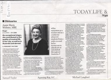
Document - BARBARA MAMOUNEY COLLECTION: IMAGE AND OBITUARY OF ANNIE MAVIS WEBSTER MBE
A photocopy of newspaper publication of obituary for Annie Mavis Webster, MBE 21/5/1914 - 8/4/2000 An exceptional singer who contributed greatly to local Bendigo and Australia as well as abroad Bendigo born and raised by Edwin and Annie Webster, Education was at Camp Hill. A life long participation in and commitment to local music and Competition Society provided opportunities for performance. The ultimate prize for amateur singers at the time was the Sun News Pictorial Aria Competition, which Mavis attained as runner up in 1938 and as winner in 1939. Outbreak of WWII curtailed early opportunities for overseas travel but there was much call for her as recitalist, artist and teacher such as at The Sisters of Mercy at St Mary's Convent, Bendigo where she taught singing. Mavis gained impressive reputation and experience in numerous roles including as chorister (and founder of the all female choir and the Benola singers which she also named, after her home), and later (1960) included male voices; she was also conductor; musical director; and adjudicator at Eisteddfords. She laso taught at Girton, St Killian's. During the 1950s Mavis went on a very successful 9 month overseas trip on which she was inspired in many respects including the formation of the choirs. In 1978 Mavis was made a Member of the British Empire for her services to music.City of Greater Bendigo acknowledged Mavis contribution and skills by establishing the Mavis Webster Vocal Collection at the City library.bendigo, history, obituary and biography of annie mavis webster mbe, forest st methodist (now uniting) bendigo, girton, st killian's, herald sun aria, the eisteddford, sisters of mercy at st mary's convent, mavis webster vocal collection, city of greater bendigo, margaret watters. -
 Victorian Aboriginal Corporation for Languages
Book, William B McGregor, Encountering Aboriginal languages : studies in the history of Australian linguistics, 2008
"This edited volume represents the first book-length study of the history of research on Australian Aboriginal languages, and collects together 18 original papers on a wide variety of topics, spanning the period from first settlement to the present day. The introduction sets the scene for the book by presenting an overview of the history of histories of research on the languages of Australia , and identifying some of the major issues in Aboriginal linguistic historiography as well as directions for future investigations. Part 1 presents three detailed investigations of the history of work on particular languages and regions.The eight papers of Part 2 study and re-evaluate the contributions of particular individuals, most of who are somewhat marginal or have been marginalised in Aboriginal linguistics. Part 3 consists of six studies specific linguistic topics: sign language research, language revival, pidgins and creoles, fieldwork, Fr. Schmidt's work on personal pronouns, and the discovery that Australia was a multilingual continent. Overall, the volume presents two major challenges to Australianist orthodoxy. First, the papers challenge the typically anachronistic approaches to the history of Aboriginal linguistics, and reveal the need to examine previous research in the context of their times - and the advantages of doing so to contemporary understanding and language documentation. Second, the widespread presumption that the period 1910-1960 represented the 'dark ages' of Aboriginal linguistics, characterised by virtually no linguistic work, is refuted by a number of studies in the present volume."B&w photographs, maps -
 Kew Historical Society Inc
Plan, Melbourne & Metropolitan Board of Works : Borough of Kew : Detail Plan No.1576, 1904
The Melbourne and Metropolitan Board of Works (MMBW) plans were produced from the 1890s to the 1950s. They were crucial to the design and development of Melbourne's sewerage and drainage system. The plans, at a scale of 40 feet to 1 inch (1:480), provide a detailed historical record of Melbourne streetscapes and environmental features. Each plan covers one or two street blocks (roughly six streets), showing details of buildings, including garden layouts and ownership boundaries, and features such as laneways, drains, bridges, parks, municipal boundaries and other prominent landmarks as they existed at the time each plan was produced. (Source: State Library of Victoria)This plan forms part of a large group of MMBW plans and maps that was donated to the Society by the Mr Poulter, City Engineer of the City of Kew in 1989. Within this collection, thirty-five hand-coloured plans, backed with linen, are of statewide significance as they include annotations that provide details of construction materials used in buildings in the first decade of the 20th century as well as additional information about land ownership and usage. The copies in the Public Record Office Victoria and the State Library of Victoria are monochrome versions which do not denote building materials so that the maps in this collection are invaluable and unique tools for researchers and heritage consultants. A number of the plans are not held in the collection of the State Library of Victoria so they have the additional attribute of rarity.Original survey plan, issued by the MMBW to a contractor with responsibility for constructing sewers in the area identified on the plan within the Borough of Kew. The plan was at some stage hand-coloured, possibly by the contractor, but more likely by officers working in the Engineering Department of the Borough and later Town, then City of Kew. The hand-coloured sections of buildings on the plan were used to denote masonry or brick constructions (pink), weatherboard constructions (yellow), and public buildings (grey). Development in the 20th century has irreparably altered that part of Kew represented in this plan. In the block bounded by Cotham Road, Charles Street, Wellington Street and Gellibrand; just one house standing in 1903 remains. This block included two of the most historic houses in Kew: ‘Ordsall’ (later ‘Southesk’) and ‘Madford’ (previously ‘Elm Lodge’). Ordsall was the home of the second chairman of Kew, John Halfey. It contained some of the most significant interior murals in Kew, created for Halfey by artists working for Cullen & Co. It was demolished in 1960 to make way for the Kew Civic Centre. Elm Lodge had been built for William Siddeley in ca. 1864. Arthur Septimus King purchased it in 1874. The lower paddocks of Madford were sold in 1905 by his wife to the Borough of Kew and, after landscaping by George and Thomas Pockett, opened as the Alexandra Gardens in 1908. Elm Lodge/Madford was in 1922 to become St. Anthony’s Home for Little Children before its subsequent demolition in the 1980s.melbourne and metropolitan board of works, detail plans, maps - borough of kew, mmbw 1576, cartography -
 Bendigo Historical Society Inc.
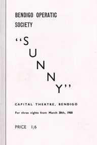
Programme - BENDIGO OPERATIC SOCIETY PROGRAMME ''SUNNY''
Programme Bendigo Operatic Society ''Sunny'' Capital Theatre Bendigo for three nights from March 30th, 1960. Price 1/6. Producer Mr. Charles Norman - Patricia McCracken as Sunny Peters - Fred Trewarne as Tom Warren - Annette Wilson as Weenie Winters - Bryan Brewer as Jim Deeming - Bram Schrever as Siegfried Peters - Emily Westgarth as Marcia Manners - Valerie McCracken as Sue Warren - Alfred Annison as Harold Wendall-Wendall Musical Director Max O' Loghlen - Society Pianist: Mrs. Phyllis House - Ballet Mistress: Miss Madge Welch. ''Sunny'' A Musical Comedy in two Acts Music by Jerome Kern, Book & Lyrics by Otto Harbach & Oscar Hammerstein. Cast in Order of appearance: Bally Hoo (The Barker); George Steele - Tom Warren: Fred Trewarne - Harold Harcourt Wendall (Owner of Wendall's Circus): Alfred Annison - Siegfried Peters (Manager of Circus: Bram Schrever - Sue Warren (Suzette): Valerie McCracken - Sunny Peters Patricia McCracken - Jim Deeming (A Friend of Tom Warren): Bryan Brewer - Weenie Winters: Annette Wilson - Sam (a Circus Rouseabout): Denis Cremin - Marcia Manners (Tom Warren's Fiancé): Emily Westgarth - 1st Officer: Peter Houston - 2nd Officer: Robert Nichols - Captain: Vincent Dáraugo - Specialty Dancers: The Dale Sistersprogram, theatre, bendigo operatic society -
 Melbourne Tram Museum
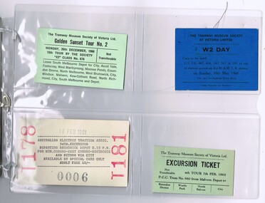
Ephemera - Ticket/s, Tramway Museum Society of Victoria (TMSV), Set of 12 tickets for Melbourne tram tours, 1961 to 1968
Set of 12 tickets for Melbourne tram tours contained within a Pacific Film Laboratory folder. Collected by Ian Stanley at the time of the tour. .1 - TMSV Golden Sunset Tour No. 2 - 26-12-1966 - printed on light green card. .2 - TMSV W2 Day tour - 19-5-1968, printed on dark blue card - see also Reg Item No. 605. .3 - AETA - 30th Excursion - Brunswick depot - 18-2-1961 - ticket No. 006, printed on manila card. .4 - TMSV - 4th tour - 7-2-1965 - 980 ex Malvern Depot - printed on light green card. .5 - TMSV - 19th tour - 18-6-1967 - printed on light green card. .6 - ARE - Tram tour 17 - 17-12-1967 - printed on manila card. .7 - TMSV Golden Sunset Tour No. 3 - 26-12-1967 - printed on manila card. .8 - TMSV Golden Sunset Tour 26-12-1965 - printed on manila card. .9 - TMSV - MBCTT 50th anniversary tour - 24-4-1966 printed on manila card. .10 - TMSV - Kew tour - tour No. 2 - 6-5-1964 printed on yellow card. .11 - TMSV - Richmond cable tram commemoration - 14-11-1965 - printed on pink card, has advertisement for the Model Dockyard on the rear. .12 - TMSV tour ticket for 17-11-1963 - Y1 613, ex South Melbourne - printed on long pink card which has been folded for storage..8 - has written in ink "Mr. I. J. Stanley 1-5.0"trams, tramways, tmsv, are, aeta, tickets, tours, models -
Bendigo Historical Society Inc.
Map - Black and white map pertaining to Lake Eppalock
John Perry Collection. Laminated copy of map relating to Lake Eppalock. Lists dwellings, ford crossings and bridges. The dam was built by the State Rivers and Water Supply Commission of Victoria. The dam wall height is 45 metres (148 ft) and the main embankment is 1,041 metres (3,415 ft) long. At 100% capacity the dam wall was designed to hold back 304,651 megalitres (6.7014×10¹⁰ imp gal; 8.0480×10¹⁰ US gal) of water. The surface area of Lake Eppalock is 3,011 hectares (7,440 acres) and the catchment area is 2,124 square kilometres (820 sq mi). The controlled spillway is capable of discharging 8,040 cubic metres per second (284,000 cu ft/s). Lake Eppalock supplies both stock and domestic water to the Campaspe irrigation district. It also serves as a water supply to Bendigo and Heathcote and, in more recent times, Ballarat. The lake is a major attraction for those engaging in watersports, with a number of tourist parks and accommodation facilities available. Permissible activities on the lake include high-speed boating, water skiing, sailing, canoeing, fishing and swimming. The lake's water levels were low for approximately eight years between 2002 and 2010 during a prolonged drought, which restricted the amount of recreational activity until rainfall in the latter half of 2010 returned the lake to 100 percent capacity. Built between 1961 and 1964, Lake Eppalock remains the only water storage on the Campaspe River system.map, water, dam, reservoir, eppalock -
Bendigo Historical Society Inc.
Map - Black and white map pertaining to Lake Eppalock
John Perry Collection. Laminated copy of map pertaining to Lake Eppalock. Gives details of dwellings, bridges and ford crossings. The dam was built by the State Rivers and Water Supply Commission of Victoria. The dam wall height is 45 metres (148 ft) and the main embankment is 1,041 metres (3,415 ft) long. At 100% capacity the dam wall was designed to hold back 304,651 megalitres (6.7014×10¹⁰ imp gal; 8.0480×10¹⁰ US gal) of water. The surface area of Lake Eppalock is 3,011 hectares (7,440 acres) and the catchment area is 2,124 square kilometres (820 sq mi). The controlled spillway is capable of discharging 8,040 cubic metres per second (284,000 cu ft/s). Lake Eppalock supplies both stock and domestic water to the Campaspe irrigation district. It also serves as a water supply to Bendigo and Heathcote and, in more recent times, Ballarat. The lake is a major attraction for those engaging in watersports, with a number of tourist parks and accommodation facilities available. Permissible activities on the lake include high-speed boating, water skiing, sailing, canoeing, fishing and swimming. The lake's water levels were low for approximately eight years between 2002 and 2010 during a prolonged drought, which restricted the amount of recreational activity until rainfall in the latter half of 2010 returned the lake to 100 percent capacity. Built between 1961 and 1964, Lake Eppalock remains the only water storage on the Campaspe River system.eppalock, map, water, dam, reservoir -
Bendigo Historical Society Inc.
Document - Legend to maps A, B and C for Lake Eppalock
John Perry Collection. Laminated 'legend' for Maps A, B and C for Lake Eppalock also in this collection. Black and White definitions and descriptions of objects and markers found on maps. Circa 1951. The dam was built by the State Rivers and Water Supply Commission of Victoria. The dam wall height is 45 metres (148 ft) and the main embankment is 1,041 metres (3,415 ft) long. At 100% capacity the dam wall was designed to hold back 304,651 megalitres (6.7014×10¹⁰ imp gal; 8.0480×10¹⁰ US gal) of water. The surface area of Lake Eppalock is 3,011 hectares (7,440 acres) and the catchment area is 2,124 square kilometres (820 sq mi). The controlled spillway is capable of discharging 8,040 cubic metres per second (284,000 cu ft/s). Lake Eppalock supplies both stock and domestic water to the Campaspe irrigation district. It also serves as a water supply to Bendigo and Heathcote and, in more recent times, Ballarat. The lake is a major attraction for those engaging in watersports, with a number of tourist parks and accommodation facilities available. Permissible activities on the lake include high-speed boating, water skiing, sailing, canoeing, fishing and swimming. The lake's water levels were low for approximately eight years between 2002 and 2010 during a prolonged drought, which restricted the amount of recreational activity until rainfall in the latter half of 2010 returned the lake to 100 percent capacity. Built between 1961 and 1964, Lake Eppalock remains the only water storage on the Campaspe River system.map, water, dam, reservoir, eppalock -
Bendigo Historical Society Inc.
Map - Map of overlay of lake Eppalock at full capacity. Map 'C'
John Perry collection. Map 'C'. Laminated map of overlay of Lake Eppalock at full capacity. Circa 1951. The dam was built by the State Rivers and Water Supply Commission of Victoria. The dam wall height is 45 metres (148 ft) and the main embankment is 1,041 metres (3,415 ft) long. At 100% capacity the dam wall was designed to hold back 304,651 megalitres (6.7014×10¹⁰ imp gal; 8.0480×10¹⁰ US gal) of water. The surface area of Lake Eppalock is 3,011 hectares (7,440 acres) and the catchment area is 2,124 square kilometres (820 sq mi). The controlled spillway is capable of discharging 8,040 cubic metres per second (284,000 cu ft/s). Lake Eppalock supplies both stock and domestic water to the Campaspe irrigation district. It also serves as a water supply to Bendigo and Heathcote and, in more recent times, Ballarat. The lake is a major attraction for those engaging in watersports, with a number of tourist parks and accommodation facilities available. Permissible activities on the lake include high-speed boating, water skiing, sailing, canoeing, fishing and swimming. The lake's water levels were low for approximately eight years between 2002 and 2010 during a prolonged drought, which restricted the amount of recreational activity until rainfall in the latter half of 2010 returned the lake to 100 percent capacity. Built between 1961 and 1964, Lake Eppalock remains the only water storage on the Campaspe River system.map, water, eppalock, dam, reservoir -
Bendigo Historical Society Inc.
Map - Laminated map of Lake Eppalock empty. Map 'D'
John Perry Collection. Laminated map of Lake Eppalock empty. Map 'D'. Circa 1951. The dam was built by the State Rivers and Water Supply Commission of Victoria. The dam wall height is 45 metres (148 ft) and the main embankment is 1,041 metres (3,415 ft) long. At 100% capacity the dam wall was designed to hold back 304,651 megalitres (6.7014×10¹⁰ imp gal; 8.0480×10¹⁰ US gal) of water. The surface area of Lake Eppalock is 3,011 hectares (7,440 acres) and the catchment area is 2,124 square kilometres (820 sq mi). The controlled spillway is capable of discharging 8,040 cubic metres per second (284,000 cu ft/s). Lake Eppalock supplies both stock and domestic water to the Campaspe irrigation district. It also serves as a water supply to Bendigo and Heathcote and, in more recent times, Ballarat. The lake is a major attraction for those engaging in watersports, with a number of tourist parks and accommodation facilities available. Permissible activities on the lake include high-speed boating, water skiing, sailing, canoeing, fishing and swimming. The lake's water levels were low for approximately eight years between 2002 and 2010 during a prolonged drought, which restricted the amount of recreational activity until rainfall in the latter half of 2010 returned the lake to 100 percent capacity. Built between 1961 and 1964, Lake Eppalock remains the only water storage on the Campaspe River system.map, water, dam, reservoir, eppalock -
Bendigo Historical Society Inc.
Document - Collection of photographs from newspaper on a single page
John Perry Collection. Laminated copy of page from 'Weekly Times' newspaper, February, 1962. Nine images relating to establishing and building Eppalock Reservoir, 15 miles from Bendigo. The dam was built by the State Rivers and Water Supply Commission of Victoria. The dam wall height is 45 metres (148 ft) and the main embankment is 1,041 metres (3,415 ft) long. At 100% capacity the dam wall was designed to hold back 304,651 megalitres (6.7014×10¹⁰ imp gal; 8.0480×10¹⁰ US gal) of water. The surface area of Lake Eppalock is 3,011 hectares (7,440 acres) and the catchment area is 2,124 square kilometres (820 sq mi). The controlled spillway is capable of discharging 8,040 cubic metres per second (284,000 cu ft/s). Lake Eppalock supplies both stock and domestic water to the Campaspe irrigation district. It also serves as a water supply to Bendigo and Heathcote and, in more recent times, Ballarat. The lake is a major attraction for those engaging in watersports, with a number of tourist parks and accommodation facilities available. Permissible activities on the lake include high-speed boating, water skiing, sailing, canoeing, fishing and swimming. The lake's water levels were low for approximately eight years between 2002 and 2010 during a prolonged drought, which restricted the amount of recreational activity until rainfall in the latter half of 2010 returned the lake to 100 percent capacity. Built between 1961 and 1964, Lake Eppalock remains the only water storage on the Campaspe River system. dam, engineering, water, eppalock -
Bendigo Historical Society Inc.
Map - Laminated map of Lake Eppalock at full capacity
John Perry Collection. Laminated copy of map of Lake Eppalock at full capacity. Had highlighter markings of old roads which appear to be still in use. The dam was built by the State Rivers and Water Supply Commission of Victoria. The dam wall height is 45 metres (148 ft) and the main embankment is 1,041 metres (3,415 ft) long. At 100% capacity the dam wall was designed to hold back 304,651 megalitres (6.7014×10¹⁰ imp gal; 8.0480×10¹⁰ US gal) of water. The surface area of Lake Eppalock is 3,011 hectares (7,440 acres) and the catchment area is 2,124 square kilometres (820 sq mi). The controlled spillway is capable of discharging 8,040 cubic metres per second (284,000 cu ft/s). Lake Eppalock supplies both stock and domestic water to the Campaspe irrigation district. It also serves as a water supply to Bendigo and Heathcote and, in more recent times, Ballarat. The lake is a major attraction for those engaging in watersports, with a number of tourist parks and accommodation facilities available. Permissible activities on the lake include high-speed boating, water skiing, sailing, canoeing, fishing and swimming. The lake's water levels were low for approximately eight years between 2002 and 2010 during a prolonged drought, which restricted the amount of recreational activity until rainfall in the latter half of 2010 returned the lake to 100 percent capacity. Built between 1961 and 1964, Lake Eppalock remains the only water storage on the Campaspe River system.map, water, dam, reservoir, eppalock -
Bendigo Historical Society Inc.
Map - Black and White map. Outline of Lake Eppalock. Map 'B'
John Perry Collection. Laminated copy black and white map. Map 'B'. Outline of Lake Eppalcok, overlayed on map. Circa 1951. The dam was built by the State Rivers and Water Supply Commission of Victoria. The dam wall height is 45 metres (148 ft) and the main embankment is 1,041 metres (3,415 ft) long. At 100% capacity the dam wall was designed to hold back 304,651 megalitres (6.7014×10¹⁰ imp gal; 8.0480×10¹⁰ US gal) of water. The surface area of Lake Eppalock is 3,011 hectares (7,440 acres) and the catchment area is 2,124 square kilometres (820 sq mi). The controlled spillway is capable of discharging 8,040 cubic metres per second (284,000 cu ft/s). Lake Eppalock supplies both stock and domestic water to the Campaspe irrigation district. It also serves as a water supply to Bendigo and Heathcote and, in more recent times, Ballarat. The lake is a major attraction for those engaging in watersports, with a number of tourist parks and accommodation facilities available. Permissible activities on the lake include high-speed boating, water skiing, sailing, canoeing, fishing and swimming. The lake's water levels were low for approximately eight years between 2002 and 2010 during a prolonged drought, which restricted the amount of recreational activity until rainfall in the latter half of 2010 returned the lake to 100 percent capacity. Built between 1961 and 1964, Lake Eppalock remains the only water storage on the Campaspe River system.map, water, dam, reservoir, eppalock -
Bendigo Historical Society Inc.
Map - General view of area of proposed construction of Lake Eppalock. Map 'A'
John Perry Collection. Laminated map of proposed construction of Lake Eppalock. Map 'A'. Black and white map in laminate. Circa 1951. The dam was built by the State Rivers and Water Supply Commission of Victoria. The dam wall height is 45 metres (148 ft) and the main embankment is 1,041 metres (3,415 ft) long. At 100% capacity the dam wall was designed to hold back 304,651 megalitres (6.7014×10¹⁰ imp gal; 8.0480×10¹⁰ US gal) of water. The surface area of Lake Eppalock is 3,011 hectares (7,440 acres) and the catchment area is 2,124 square kilometres (820 sq mi). The controlled spillway is capable of discharging 8,040 cubic metres per second (284,000 cu ft/s). Lake Eppalock supplies both stock and domestic water to the Campaspe irrigation district. It also serves as a water supply to Bendigo and Heathcote and, in more recent times, Ballarat. The lake is a major attraction for those engaging in watersports, with a number of tourist parks and accommodation facilities available. Permissible activities on the lake include high-speed boating, water skiing, sailing, canoeing, fishing and swimming. The lake's water levels were low for approximately eight years between 2002 and 2010 during a prolonged drought, which restricted the amount of recreational activity until rainfall in the latter half of 2010 returned the lake to 100 percent capacity. Built between 1961 and 1964, Lake Eppalock remains the only water storage on the Campaspe River system.map, dam, water, weir, eppalock -
Bendigo Historical Society Inc.
Map - Laminated worksheet - identification of inundated artifacts at Lake Eppalock
John Perry Collection. Laminated copy of worksheet identifying inundated artifacts at Lake Eppalock when at 10% capacity. The dam was built by the State Rivers and Water Supply Commission of Victoria. The dam wall height is 45 metres (148 ft) and the main embankment is 1,041 metres (3,415 ft) long. At 100% capacity the dam wall was designed to hold back 304,651 megalitres (6.7014×10¹⁰ imp gal; 8.0480×10¹⁰ US gal) of water. The surface area of Lake Eppalock is 3,011 hectares (7,440 acres) and the catchment area is 2,124 square kilometres (820 sq mi). The controlled spillway is capable of discharging 8,040 cubic metres per second (284,000 cu ft/s). Lake Eppalock supplies both stock and domestic water to the Campaspe irrigation district. It also serves as a water supply to Bendigo and Heathcote and, in more recent times, Ballarat. The lake is a major attraction for those engaging in watersports, with a number of tourist parks and accommodation facilities available. Permissible activities on the lake include high-speed boating, water skiing, sailing, canoeing, fishing and swimming. The lake's water levels were low for approximately eight years between 2002 and 2010 during a prolonged drought, which restricted the amount of recreational activity until rainfall in the latter half of 2010 returned the lake to 100 percent capacity. Built between 1961 and 1964, Lake Eppalock remains the only water storage on the Campaspe River system.map, artifacts, eppalock, reservoir -
Ballarat Tramway Museum
Memorabilia - Exhibition Material, Warren Doubleday, "gold!, Gold!, GOLD! and Trams", 29/01/2003 12:00:00 AM
Two photos and thirty captions or label cards used in the Museum's exhibition entitled "gold!, Gold!, GOLD! and Trams". Printed on a colour laser jet, 200 gsm card, unless noted otherwise. Most cards have two Velcro dots on rear, except larger ones which may have three or four. .1 151 x 210 Opening Tram Leonora Tramways - supplied by the Perth Electric Tramway Society .2 210 x 292 Kalgoorlie Electric Tramways Limited trams No. 19 and 13 - ex PETS .3 210 x 297 Gold and Tramways of Ballarat - text card.. .4 210 x 297 text card - 2nd card. .5 130 x 210 Acknowledgements card. .6 - .8 97 x 297 - "GOLD!" on each card, with a heavier font each time. .9 172 x 297 "and trams" .10 136 x 297 "Painted to Celebrate" .11 383 x 80 "At first horses" .12 62 x 472 "Then came Electric" - Two pieces of card joined together, stored folded. .13 65 x 557 "and other Golden Cities" - Two pieces of card joined together, stored folded. .14 68 x 550 "For the City of Ballarat" - Two pieces of card joined together, stored folded. .15 47 x 385 "To Ballarat East as well" .16 45 x 90 "Main St" / "Photo Wal Jack 1963 btm362" .17 46 x 194 "Main and Victoria Sts" / "Photo Ron Fluck 1950 btm870" .18 69 x 126 "1964 Sebastopol" / "Photo Tramway Museum Society of Victoria" .19 66 x 99 "1951 Ballarat / Photo Keith Kings btm1378" .20 45 x 102 "Bendigo N.J. Simons Collection btm 1205.7" .21 68 x 106 "2001 Ballarat / Photo Warren Doubleday" .22 43 x 157 "To Sebastopol / From E.D. Jenkins book, Sebastopol Victoria 1864-1964 btm1090" .23 43 x 158 "From the City / Charles Rudd photograph, State Library of Victoria btm 1113i" .24 43 x 271 "Electric Power for Industry / BTM Collection btm 698i" .25 47 x 160 "To the Gardens / From Geo Rose stereo pair. Donated by Bacchus Marsh Blacksmith Cottage and Forge btm1257" .26 41 x 96 "Leonora / Courtesy Perth Electric Tramway Society" .27 45 x 117 "Bridge St / Postcard from Norm DePomeroy collection btm 841" .28 46 x 169 "Transport for all / Postcard from Norm DePomeroy collection btm837" .29 44 x 89 "Main St / Photo Ron Fluck 1962 btm867" .30 41 x 117 "Kalgoorlie / Courtesy Perth Electric Tramway Society" .31 46 x 150 "1905 Opening / BTM Collection btm482" .32 52 x 404 "Ballarat Trams are Ballarat History"trams, tramways, btm, exhibitions, gold!, gold!, gold! and trams, gold tram -
 Eltham District Historical Society Inc
Photograph - Digital Photograph, Alan King, Nillumbik Shire Offices, Greensborough, 30 March 2008
Nillumbik Shire Council transferred to the former Diamond Valley Shire Offices in Greensborough after municipal restructuing. The offices became the official Nillumbik Shire Council Offices on 16 October 1995. The former Shire of Diamond Valley Civic Centre or Shire Office building was officially opened on 26th February 1972. Archtiects were A.K. Lines, McFarlane & Marshall and it was built by L.U. Simon Pty Ltd, The Diamond Valley Shire had been created in 1964 from part of the City of Heidelberg. On December 15, 1994 the Shire of Nillumbik was established. Under the Council amalgamations imposed by the Kennett government, the Shire of Eltham, Shire of Diamond Valley and City of Heidelberg ceased to exist with the establishment of Nillumbik Shire Council and the City of Banyule.The new Nillumbik shire surrended the west riding from Eltham to Banyule but in place gained parts of the former Diamond Valley Shire which itself had been created in 1964 from parts of the City of Heidelberg. Three unelected and non-local Commissioners were put in place by the government bringing democracy into question by many members of the local community. The Commissioners determined to abandon the former Shire of Eltham offices located in Main Road, Eltham and in turn occupy the former Shire of Diamond Valley offices located at the boundary of the new shire with Banyule, in Civic Drive, Greensborough. In July 1996 the Commissioners sold the former Eltham Shire Offices and had them bulldozed leading to many years of communiity protest over the process and future development applications. The site has remained vacant ever since. Published: Nillumbik Now and Then / Marguerite Marshall 2008; photographs Alan King with Marguerite Marshall.; p43 It was the need for roads that led to this district’s first council. In 1853 a committee was formed to improve the rough roads, some in Kangaroo Ground being almost impassable in winter.1 The committee fundraised by voluntary levies and grants to improve in particular, the main road between Kangaroo Ground and the Plenty River. From this committee arose the Eltham District Road Board, in 1856, which was the precursor to the Eltham Shire Council. The Board’s first chairman was Kangaroo Ground farmer, John Barr. Secretary was the former committee’s secretary, Andrew Ross, Kangaroo Ground’s first school teacher, and founder of the district newspaper, The Evelyn Observer.2 Most of the board’s income came from a toll-house north of the Lower Plenty Bridge, which funded such projects as a road from Kangaroo Ground to the Caledonia Diggings. In 1871 the Shire of Eltham was proclaimed, with its boundaries the same as those of the Road Board, and Councillor A Donaldson of Kangaroo Ground was the first president. Eltham was at the southern tip of the shire, which extended north to Kinglake and east beyond Yarra Glen. In 1878, part of Kinglake was added to the shire, while the area east of Watts River, near Healesville was removed. In 1912, then again in 1958, the shire was further reduced. Yarra Glen, Steels Creek, Tarrawarra, parts of Healesville and Christmas Hills, were transferred to the Shire of Healesville. In 1972 a smaller area, at Kinglake, was transferred to the Shire of Yea, leaving 277 square kilometres in the Eltham Shire. Perhaps no other Victorian municipality has had so many meeting places. Although from 1858 to 1904, the council convened at the office in the home of Secretary Charles Wingrove, the board, and later the council, also met at other more central locations.3 The board moved from the Fountain of Friendship Hotel to the Eltham Courthouse, to the Kangaroo Ground schoolhouse. It then met at the Kangaroo Ground Hotel, which some considered put it in danger of interruptions by people ‘the worse for liquor’.4 In 1885 the council met at the hall on Mr J Donaldson’s land at Kangaroo Ground. After Wingrove’s retirement, the council rented space at the Kangaroo Ground General Store and Post Office. Then, in 1917, the council bought the former office of The Evelyn Observer, after its printing works transferred to Hurstbridge. In 1934, fire destroyed the shire office, which was temporarily relocated to the Kangaroo Ground home of Shire Secretary, Mr P J McMahon. In 1941, the shire office moved to a new building (which included a public hall) in Eltham, at the corner of Arthur Street and Main Road, where the Eltham Village Shopping Centre was eventually built. Growth required new offices, which opened in 1965, on the former Shillinglaw property in Main Road.5 In 1994, as part of municipal restructuring under the Jeff Kennett Liberal Government, most of the Eltham Shire formed part of the new Shire of Nillumbik. It joined with the north section of the Diamond Valley Shire and parts of the Healesville and Whittlesea municipalities. The Diamond Valley Shire had been created in 1964, from part of the City of Heidelberg. Turbulence followed Nillumbik Shire’s formation. Under the Commissioners the council transferred to the former Diamond Valley Shire offices in Greensborough, and the Eltham council offices were demolished. In March 1997 the first five-member Nillumbik Council was elected. But, in October 1998, the government suspended the council and appointed an administrator . Early in 1999, shire residents voted to increase councillors to nine: comprising five ward councillors and four shire-wide councillors. Elections were held in March 1999. Then, before the March 2002 elections, nine new wards were created.6 In 2008 these were reduced to seven. Today [2008] the council governs a varied population of more than 60,000 people living in townships and on bush properties in the green wedge.This collection of almost 130 photos about places and people within the Shire of Nillumbik, an urban and rural municipality in Melbourne's north, contributes to an understanding of the history of the Shire. Published in 2008 immediately prior to the Black Saturday bushfires of February 7, 2009, it documents sites that were impacted, and in some cases destroyed by the fires. It includes photographs taken especially for the publication, creating a unique time capsule representing the Shire in the early 21st century. It remains the most recent comprehenesive publication devoted to the Shire's history connecting local residents to the past. nillumbik now and then (marshall-king) collection, greensborough, nillumbik shire council offices, civic drive