Showing 1473 items
matching c hill
-
 Stawell Historical Society Inc
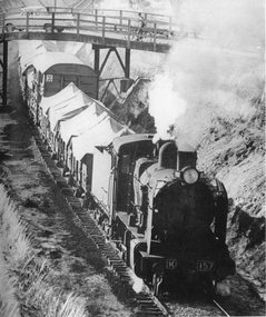
Photograph, K Class 157 Steam Engine pulling freight
... under Colquhuon Street bridge. Photo was taken from Hill Street... under Colquhuon Street bridge. Photo was taken from Hill Street ...K Class 157 Steam Train Engine pulling freight in cutting under Colquhuon Street bridge. Photo was taken from Hill Street Stawell around c 1962. Copy from original photograph of "K" Class 157 Steam engine pulling freight trucks going up the cutting and under the Colquhuon St. bridge. The rail line runs parallel to Napier St. c 1962. K 157.railways -
 Stawell Historical Society Inc
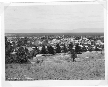
Photograph, Panorama Of Stawell from Big Hill with Town Hall and St Matthew's Church
... Panorama of Stawell from Big Hill Grampians in background... grampians Panorama of Stawell from Big Hill Grampians in background ...Panorama of Stawell from Big Hill Grampians in background. c 1940View of Stawell with the Grampians in the background, a grassed area in the foreground with a line of pine trees in front of the town.Panorama Of Stawellstawell, panorama -
 Stawell Historical Society Inc
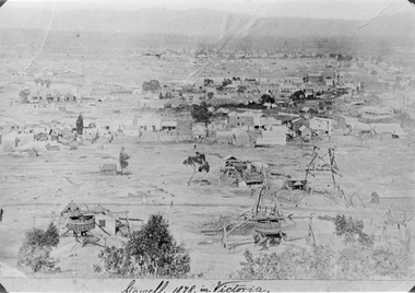
Photograph, Panorama of Stawell from Big Hill 1878, North Scotchmans No6 and No7 and South Cross Mine whims and Poppet Heads
Scene from Big Hill. Shows Stawell looking to West c 1878 Patrick Streets and Sloane Street intersection. Back of Royal Exchange Hotel Kays Foundry in Wimmera Street. Coffee Palace formerly Castlemaine Hotel at right of photo. Mining poppet heads in foreground Three Whims in the foreground are North Scotchmans No 6 & 7 and South Cross in CentreSepia toned print & also a Black & White print (these photos are similar to 29.9). Photos show Western view of mining activity in Stawell c 1878. Kays Foundry on upper left and Upper Main Street on very right of photo.Stawell 1878 in Victoria.stawell, mining, panorama, streatscape -
 Stawell Historical Society Inc
Photograph, Panorama of Stawell from Big Hill with Whims & Poppet Heads Victorian Views Collection C Herbert c.1880s
Views from Big Hill Sloane Street Fisher Street areas looking towards West. Mining in foreground of photo. Upper Main Street and Patrick Street Streetscapes visible. Mathers and Franklin. Agnew Draper. J R Franklin? Draper. Coffee Palace formerly Castlemaine Hotel , Town Hall visiblePanorama of Stawell from Big Hill showing Sloane's St. / Fisher St. areas. The photo has Whims & Poppet Heads in the foreground. There are around 6 copes of the photograph. Victorian Views. C. Herbert. Photo. Copyright Registered. Stawellstawell, panorama, mining, streetscape -
 Stawell Historical Society Inc
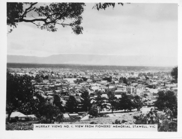
Photograph, Panorama of Stawell from Pioneers Memorial. Murray Views No. 4
Panorama of Stawell from Big Hill. Murray Views No. 4. View from Pioneer Memorial Post c 1939Black & White photo of Stawell from Pioneers Memorial post c 1939. Murray Views No. 4, View from Pioneer's Memorial Stawell, Vic.stawell, panorama -
 Stawell Historical Society Inc
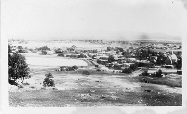
Photograph, Panorama of Stawell from Big Hill with the Stawell Water Supply Dam and St Patrick Church c 1928
... . 14-4-28. Stawell from Big Hill Original photograph c 1928 ...Panorama from Big Hill showing water Reservoir and back of St Patrick's Church and Crudace Street. Mining holes in foreground on side of Big HillOriginal photograph c 1928 of Stawell from Big Hill & 2 enlargements. RB 1232. 14-4-28. Stawell from Big Hill stawell, panorama, streetscape -
 Stawell Historical Society Inc
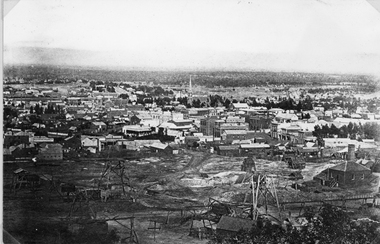
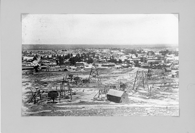
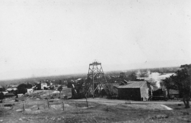
Photograph, Panorama of Stawell from Big Hill with Whims, Poppet Heads & Leaning Shed c 1878
Scene from Big Hill. Market Building in Skene Street at left of Stawell Court House. Businesses at corner of Sloane and Patrick Streets visible. Agnew Drapers store and buildings in upper Main Street visible Shows Mining activity in foreground 1878. Whim in foreground is No7 North Scotchmans and Whim next to that No8 North ScotchmansBlack & White Photograph from Big Hill. Market building left of Court house . Photo shows mining activity in the foreground, Stawell in the background c 1878. refer. Original c 1880 folder (room 2) from Don Rickard & Geoff Oates.stawell, panorama, streetscape, mining -
 Stawell Historical Society Inc
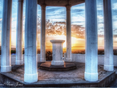
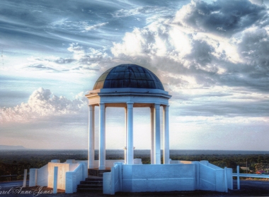
Photograph, Pioneers Memorial on Big Hill -- Sunset through its Columns -- Coloured
Looking through Pioneers Memorial Columns. The photo shows the ground floor of the Pioneers memorial with the Corinthian pillars supporting the dome. The directional pedestal is in the center installed in c 1947. The Stawell township is in the background with the sun setting behind the Grampians.Looking through Pioneers Memorial Columns with the directional pedestal in the center. The view shows the Stawell township in the background and the sun setting behind the Grampians.Carol Anne Jonesstawell -
 Stawell Historical Society Inc
Photograph, Pioneer Memorial on Big Hill looking North West -- Coloured
Pioneer Memorial looking Northwest with a spectacular sky background. The foundation stone of the memorial was laid in c 1935.Colour photograph of the magnificent Pioneers Memorial on Big Hill. View is looking toward the Northwest just showing the edge of the Grampians. Photo shows the memorial with a spectacular sky background.Carol Anne Jonesstawell -
 Stawell Historical Society Inc
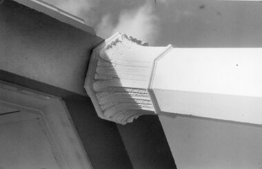
Photograph, Pioneers’ Memorial on Big Hill -- 2 Photos
Two black & white photographs of the Pioneers’ Memorial. One photo shows a close-up view of Corinthian Pillar supporting the roof of the dome. The other photo is a distant view of the memorial with a view of the directional pedestal under the dome installed in c 1947. Note the white iron posts either side of the steps to protect the memorial from external hazards.Two black and white photos of Pioneers Memorial on Big Hill Stawell. One photo shows the detail view of the top of the Corinthian pillar. The second photo is a view of the memorial showing the directional indicator pedestal installed in c 1947. The white iron posts either side of the steps on the second photo were constructed to protect the memorial from hazards such as cars.stawell -
 Stawell Historical Society Inc
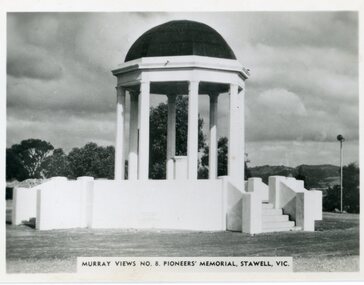
Postcard, Pioneers’ Memorial on Big Hill
Murray View No. 8. Pioneers’ Memorial photograph showing direction indicators in center of dome installed c 1947 and donated by the Stawell Progress Society. Black and white Murray Views photograph of Pioneers Memorial showing the direction indicator in the center. The direction indicator was given by the Stawell Progress Association in c 1947. Murray Views No. 8. Pioneers' Memorial, Stawell Vic. Rose Seris 12149. Same as Murray Views No 8.stawell -
 Stawell Historical Society Inc
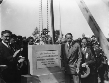
Photograph, Pioneers’ Memorial on Big Hill -- Laying the Foundation Stone c 1935
Black & white photo showing foundation stone at Pioneers’ Memorial being held in place by a crane and watched by several people. On the right side of stone is the governor of Victoria Lord Huntingfield and beside him, town clerk Mr. Sharpley with a ribbon in his lapel and holding his hat. On the left side wearing glasses is Cr. Stan Freeland. Three Black and white photos of foundation stone, held in place by a crane and watched by several people around the foundation stone c 1935. Of the three photos two are enlarged."This Federation Stone was laid by His Excellency Lord Huntingfield K.C.M.G. governor of Victoria October 7th 1935." - inscribed on the stone. stawell -
 Stawell Historical Society Inc
Print, The Picturesque Atlas of Australia, Coloured Wood Engraving of Stawell c 1866 Published in "The Picturesque Atlas of Australasia", 1886
Prepared to celebrate the centenary of Australian settlement since the arrival of the First FleetColoured print of Stawell. View from Big Hill by Hy Fulwood Circa 1866panorama, mining -
 Stawell Historical Society Inc
Photograph, Sloanes & Scotchmans Mine
... Mine taken from Big Hill Facing North West. c 1915 to 1920... of Sloane & Scotchmans United Mine taken from Big Hill Facing North ...Poppet Head and Engine House of Sloane & Scotchmans United Mine taken from Big Hill Facing North West. c 1915 to 1920mining, panorama, gold -
 Latrobe Regional Gallery
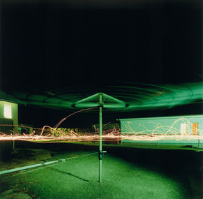
Photograph, Hills Hoist light drawing, 2003
... gippsland - Type C Pegasus print Hills Hoist light drawing ...Type C Pegasus print- -
Whitehorse Historical Society Inc.
Document, Life of Dr L.L. Smith, 1867 - 1992
1. minutes of Box Hill historical Society including talk by A.F. McInnes 2(a) Life of Dr L.L. Smith by Alan F. McInnes (b) News cutting re L.L. Smith and his son Sir Harold Gengoult Smith (c) Argus cutting re free banquet for people of Melbourne on the visit of the Duke of Edinburgh (e) Note on possible origin of the name of Whitehorse Road (f) Report by L.L. Smith on oyster beds in Westernport. (g) report by inspector of Vermont School, 1898 (h) Residence of Dr L.L. Smith (j) Article, byways of history (k) extracts from Phillip island in pictures and stories (l) Article by David Dunstan on wine making at L.L. Vale (m) Notes on property near Middleborough Road (n) Dr L.L. Smith's ointment, photocopies of 2 jar lid labels.smith, l.l., dr, pioneers, whitehorse road vermont, vermont primary school, no. 1022, smith, harold gengoult (sir) -
Whitehorse Historical Society Inc.
Document, Early hotels in Nunawading
Information copied from Cole Collection of Hotel records in La Trobe Library giving information on Blackburn Travellers rest, Mitcham Reserve Hotel, Emeries Hotel, Hill Hotel, Royal Hotel, Harvest Home, Harkaway Inn, Delaneys, Surrey Hill, Royal Hotel.alchard, mcstone, pearce, m.a., o'callaf, mary jane, mcglone, john, burrell, delaney, denis, humberstone, william, humberstone, c, hotels, travellers rest hotel, king george hotel, mitcham, reserve hotel, mitcham, emerie's hotel, mitcham, hill hotel, mitcham, royal hotel, harvest home hotel, harkaway inn, east burwood, delaney's hotel, surrey hills, royal hotel, surrey hills -
Whitehorse Historical Society Inc.
Document, F. S. Baker/ Yarra Hill country map, 1950s
Advertising leaflet for F. S. Baker, Mt. Pleasant Road Nunawading,Advertising leaflet for F. S. Baker, Mt. Pleasant Road Nunawading, Real Estate Agent c. 1950s, backed by Broadbent's Map no. 280, Yarra Hill CountryAdvertising leaflet for F. S. Baker, Mt. Pleasant Road Nunawading, broadbents, baker, f. s., mount pleasant road, nunawading, no. 20 -
Whitehorse Historical Society Inc.
Document, Nunawading Historical Society Members, 1989 - 1993
... Hill H.S .inc (c) Invitation list for the Opening of Archival...-1999|(b) 1994 Committee members of Box Hill H.S .inc|(c... members of Box Hill H.S .inc (c) Invitation list for the Opening ...A collection of names and addresses of NHS membersA collection of names and addresses of|(a) NHS members 1989-1999|(b) 1994 Committee members of Box Hill H.S .inc|(c) Invitation list for the Opening of Archival Annexe 24 July 1988|(d) NHS Membership List Jan 1995|(e) Invitation list to NHS 25th birthday|(f) 1993 Letter from Council notifying Council representatives.A collection of names and addresses of NHS members nunawading historical society, members names -
Whitehorse Historical Society Inc.
Article, Mr C E Husband, 1935
... Mitcham melbourne Husband Charles Edward Forest Hill Mr C. E ...Mr C. E. Husband celebrates 41 years in Forest Hill and recalls the developments over the years.Mr C. E. Husband celebrates 41 years in Forest Hill and recalls the developments over the years.Mr C. E. Husband celebrates 41 years in Forest Hill and recalls the developments over the years.husband, charles edward, forest hill -
 Whitehorse Historical Society Inc.
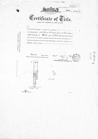
Document, Forest Hill, 24/08/1932
... of Crown Portion 93 at Forest Hill; with verso of C/T Vol 1900 Fol... of Crown Portion 93 at Forest Hill; with verso of C/T Vol 1900 Fol ...Photocopy of Certificate of TitlePhotocopy of Certificate of Title Vol 5807 Fol 1161261 to Carl Julius Otto Draeger for four acres of land being part of Crown Portion 93 at Forest Hill; with verso of C/T Vol 1900 Fol 37984 recording transfers to Lydia Esther Lovell, Lillian Sarah Frances Lovell, William John and Mabel Jessie Brown.Photocopy of Certificate of Title draeger, carl julius otto, canterbury road, forest hill, glen valley road, lovell, lydia esther, lillian sarah frances, brown, william john, mabel jessie -
 Whitehorse Historical Society Inc.
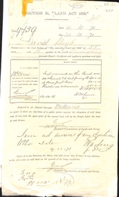
Correspondence, David Boyle's Land, 01/07/1868
Three documents related to David Boyle's land (Mount Pleasant) now in Forest Hill. (a) Application for a license to occupy. 29 July 1868. (b) Application to purchase land. 21 November 1871. (c) Letter requesting to delay purchase, written by G.A. Goodwin (Solicitor). Photocopies.boyle, david, goodwin, george augustus, mount pleasant, forest hill, orchards, land settlement -
 Whitehorse Historical Society Inc.
Report, Extracts from sales register of T.R.B. Morton
Extracts from the Sales register of T.R.B. Morton (1897 - !906) including names of people well known in Nunawading.t. r. b. morton & son, wainwright, (mrs), blood, sophia, hodgson, ellen, boyle, joseph, william james, bloom, alfred, cook, edmund a., greig, alfred woolley, crow, robert t., william hill, course, florence rebecca, charles, finger, charles henry, fankhauser, robert c, john, farmilo, hubert henry, fulton, margaret, game, thomas robinson, husband (mrs), henwood, william, dashwood, f.r., samuel j.m., blake, arthur palmer., horkings, hurter, c.e., john henry, janet, hone, robert arthur, henry john, joyner, herbert, jeffery, mary ann, keogh, james, lieber, otto, methodist boys home, purches, frederick walter, rooks, charles francis, abraham, edmund, sarah, scott, eliza emma, sergeant, frederick, henry, pickett, tainton, brock, mary theresa, thiele, ambrose frederick, walker, edgar edwardes, mary jane, zander -
Whitehorse Historical Society Inc.
Document - Ephemera, Envelope, 1/09/1985
Envelope posted 2 July 1902 from Sydney to Miss Collins c/o Chrystie, 'Merrylands', Blackburn, Vic. Explanation provided by Jean Uhl that Chrystie was a remittance man from England after deserting from the army. Lived in Quentin Street, Forest Hill (then known as Cottage Street).collins, gordon, chrystie, uhl, jean, quentin street, forest hill, cottage street, forest hill, forest hill -
Whitehorse Historical Society Inc.
Document, Burials at Aird Hill Burial Ground, c1980
... Burials at Air Hill Burial Ground : Appendix c from... Burying Ground Burials at Air Hill Burial Ground : Appendix c from ...Burials at Air Hill Burial Ground : Appendix c from 'The History of St John's Mitcham' by Syd Wright. With manuscript notes on entries registered under Box Hill.st johns catholic church, mitcham, air hill burying ground -
Whitehorse Historical Society Inc.
Map, Parkmore Estate, c1958 - 1959
Plan of 'Parkmore' subdivision by Southern Construction Company, 444 lots, c 1958-59.land subdivision, forest hill, parkmore road, forest hill, ranfurlie road, forest hill, ranfurlie court, forest hill, everglade avenue, forest hill, hampshire road, forest hill, quentin street, forest hill, cedar court, forest hill, martin court, forest hill, wandin court, forest hill, inglewood avenue, forest hill, deauville street, forest hill, oberon street, forest hill, vanbrook street, forest hill, husband road, forest hill, springvale road, forest hill, southern construction company -
 Whitehorse Historical Society Inc.
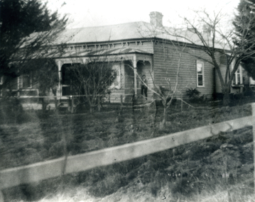
Photograph, 'Waroonga Park', Springvale Road, Tunstall (now Forest Hill), C.1911
Black and white photo of the Husband's Family Home 'Waroonga Park', Springvale Road, Tunstall (now Forest Hill). 2 copies.husband, mary c, springvale road, tunstall, charles edward, waroonga park -
 Whitehorse Historical Society Inc.
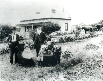
Photograph, Husband Family Group outside Family Home 'Waroonga Park', Springvale Road, Forest Hill, C.1896
Photo of Husband Family Group outside Family Home 'Waroonga Park', Springvale Road, Forest Hill.husband, mary c, springvale road, tunstall, charles edward, waroonga park -
 Whitehorse Historical Society Inc.
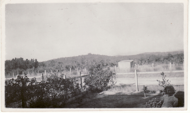
Photograph, Loughnan's Hill, Ringwood
Black and white photo showing Cook's Orchard with Loughnan's Hill, Ringwood, in the background. (Common usage 'Luffy's Hill' at the approximate time of the photograph - c.1936).- Cook's orchard mid-ground.mcniff, cooks orchard -
 Whitehorse Historical Society Inc.
Functional object - Butter Churn
Believed to have been owned originally by Alice and Arthur Fisher who had a 16 acre property in Mullum Mullum Road, Ringwood. The house was called Greenhill and was located at the highest point, now no. 28. They had a mixed farm including an orchard of fruit and nut trees, and a dairy cow. Alice milked the cow much to the amusement of her English family, who delighted in visiting. When the property was sold the butter churn went to Red Hill on the Mornington Peninsula. Arthur Lunt, donor has memories of its use in Red Hill, where his parents had a mixed farm. That property was sold c. 1950, and the butter Churn returned to the Ringwood Croydon area where it has remained unused for the last 65 years.|The butter churn has been in Croydon and Ringwood since 1952; it is typical of manually operated equipment in use on small properties 100 years ago.Cylindrical container, brown, mounted on board with handle underneath. To one side is a wooden handle and drive gears to spin cylinder. Cylinder has tight fitting lid and makers metal label on the side; opposite side has direction arrow embossed. Mounted on wooden base. Cream was put into churn, handle turned to spin drum until butter was produced. Five parts to the Churn.SVENSKA STOCKHOLM SWEDEN CENTRIFUGA,B.DAHLIA N0:0 SLATER PATENTdomestic items, food preparation