Showing 2441 items
matching goldfields north
-
 Ballarat Heritage Services
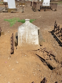
Photograph - Photograph - Colour, Clare Gervasoni, Headstone of Patrick Carroll in Tower Hill Cemetery, 2019, 03/01/2019
The Tower Hill Cemetery is located near Koroit on the north side of the Princes Highway The, between Port Fairy and Warrnambool. The first burial at Tower Hill Cemetery took place in 1856. Over 150 years there has been over 8,000 burials. Around 45 percent of the burials are in unmarked graves.Colour photograph of the headstone of Patrick Carroll in the Tower Hill Cemetery. . by Patrick Carroll InLoving Remembrance of my beloved son Patrick Who departed this life the 20th day of April 1874 Aged 2 years and 2 months Also his beloved mother Who departed this life 15th Sept 1876 Aged 74 years Also his who died 16th November 1890 Aged 89 Years Also Patrick Carroll Who died 10 July 1906 aged 72 years Rest in Peace tower hill cemetery, patrick carroll -
 Wodonga & District Historical Society Inc
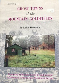
Book - Secrets of Ghost Towns of the Mountain Goldfields, Luke Steenhuis, 1999
Stories from 50 former towns in and around Melbourne's North-east mountain region. These old towns include: Aberfeldy, Aberfeldy Crossing, BB Township, Blue Jacket, Clarke's Flat, Concord Gully, Edwards Reef, Fultons Creek, Jericho, Loch Fyne, Red Jacket, Store Point, The Springs, Toombon, Toombon Upper, Tullamore, Upper Thomson, Victors Quartz, Violet Town & White Star.non-fictionStories from 50 former towns in and around Melbourne's North-east mountain region. These old towns include: Aberfeldy, Aberfeldy Crossing, BB Township, Blue Jacket, Clarke's Flat, Concord Gully, Edwards Reef, Fultons Creek, Jericho, Loch Fyne, Red Jacket, Store Point, The Springs, Toombon, Toombon Upper, Tullamore, Upper Thomson, Victors Quartz, Violet Town & White Star.ghost towns victoria, gold mining victoria -
 Wodonga & District Historical Society Inc
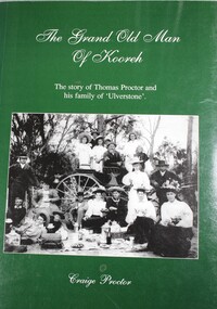
Book - The Grand Old Man of Kooreh, Craige Proctor, 1999
The story of the Thomas Proctor and his family of 'Ulverstone'. Thomas migrated to Australia in 1852 as a young boy. After time on the goldfields, Thomas took to the land, marrying the daughter of Charles Cross, a landowner at Kooreh in the North Grampians district of Victoria. Over the following decades he amassed much more land. Thomas was an astute businessman and entrepreneur - married twice and fathered 17 children. Through his benevolence towards the local community as well as his financial success Thomas became known as 'The Grand Old Man of Kooreh'.non-fictionThe story of the Thomas Proctor and his family of 'Ulverstone'. Thomas migrated to Australia in 1852 as a young boy. After time on the goldfields, Thomas took to the land, marrying the daughter of Charles Cross, a landowner at Kooreh in the North Grampians district of Victoria. Over the following decades he amassed much more land. Thomas was an astute businessman and entrepreneur - married twice and fathered 17 children. Through his benevolence towards the local community as well as his financial success Thomas became known as 'The Grand Old Man of Kooreh'.proctor family, victoria -- genealogy, kooreh victoria, thomas proctor -
 Wodonga & District Historical Society Inc
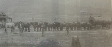
Photograph - North-Eastern Gold Days, 1900
Bethanga was established as a result of the discovery of gold. Gold was first reported in the Bethanga area in 1852. Before 1876 gold mining in the Bethanga district occurred to the north of the town and was known as the 'Talgarno diggings'. Reports of alluvial gold date back to 1852. Early gold fields were worked at Ruby Creek, Gold Creek and Jarvis Creek. The opening of the Bethanga goldfields began with the discovery of a gold-bearing quartz reef on New Year’s Day 1876. The 'Gift' mine site is located southeast of Kurrajong Gap lookout to the west of Bethanga township. The Great Eastern Copper Smelting Works was opened in 1878. Due to the nature of the gold-bearing quartz reef, the gold was difficult to extract, and the discovery of copper led to a change in focus. It was not until the early 1890s that an efficient technique for extracting the gold from the ore was discovered, and once again gold became the focus, with copper as a by-product. Bethanga was removed from the official list of goldfields in 1912, however some mining activity has taken place since.This image reflects an important time in the development of Bethanga and Northeast Victoria.A large mounted and framed image of horse teams and their owners hauling a large boiler to the gold mine near Bethanga, Victoria. On label beneath image: "North-eastern "Gold Days"/ Combined teams hauling a boiler to Bethanga Mines, 1900. Teamsters - Mr. G. Pearce, W. Chapple, G, Bannon." Donated by Ron Saunders and Barbara Cadman"bethanga, gold mining northeast victoria, gold mining bethanga, bethanga history -
 Tarnagulla History Archive
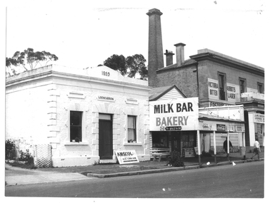
Photograph of milk bar and general store, Tarnagulla, Milk bar and general store, Tarnagulla, circa 1960s-70s
Murray Comrie Collection. This image depicts stores in the main street of Tarnagulla, including the two-storey bank building being used as a licensed general store. The building on the left was also a bank, originally constructed by the Union Bank in 1859, and Is probably the first brick and stone building at Tarnagulla. It was used by the bank until 1888 at which time the Union and Colonial banks amalgamated. After this, the building was used for a variety of purposes. The milk bar section was constructed in the 1920s in an area at the front of what had once been the Bank’s manager’s residence. The Two-story bank building On the right was constructed and used by the Colonial Bank of Australasia (from 1866 to 1888) and, following bank amalgamation, by the Union Bank (from 1888 until closure in 1942). The original site had been occupied by Joseph Foo's store, a large wooden building with attached theatre. While the bank was being built, the Colonial Bank operated from the former Company's Hotel (soon after to become the Borough of Tarnagulla Council Chambers, then the Mechanics’ Institute, and finally, prior to final demolition in 1980, Burstall Hall) The new double-storey building was used by the Colonial Bank from 1866 until 21st February, 1888. The premises were sold to the Union Bank for £2500. The Union Bank moved in and commenced operations on 6th June 1888, continuing until 1942. The building was later used as a general store until the 1990s. It is a now private residence. This is a reasonable copy of an older original. Copy probably made by Murray Comrie in the 1970s. Monochrome photograph depicting a section of Commercial Road, Tarnagulla near the intersection with Poverty Street, including two stores - one a bakery/milk-bar and the other a general store operating in the former Colonial/Union Bank building. Photograph taken from north of milk-bar. Two people walking away from photographer on footpath/curb between the two stores. The building on the left was the Union Bank premises, constructed in 1859 and Tarnagulla's oldest surviving brick building. The Union Bank absorbed the Colonial Bank in 1888, and the Union Bank moved operations next door into the much larger former Colonial Bank premises which had been constructed in 1865/66. After amalgamation, the old Union Bank premises was then used for a variety of purposes from visiting doctor's rooms to cafe, etc. The Union Bank continued to operate at Tarnagulla until closure in 1942, at which time business had fallen away and Tarnagulla Branch had already been downgraded to sub-branch status. tarnagulla, banks, banking, commerce, stores, shopping, shops, food, groceries, buildings, commercial road -
 Tarnagulla History Archive
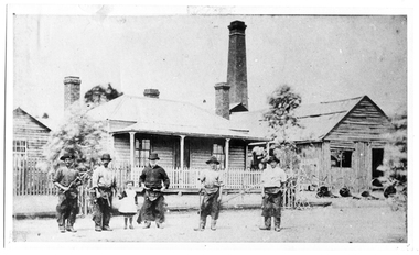
Photograph of Treloar's Foundry and employees, Tarnagulla, Treloar's Foundry and employees, Tarnagulla, between 1855 and 1894
Murray Comrie Collection. Information collated by Murray Comrie: This photograph shows the Treloar Foundry with its chimney, employees and the Treloar home in Commercial Road Tarnagulla H.W. (Henry) Treloar was a native of Redruth in Cornwall, where he was born in 1811. He worked as a blacksmith in his father's Cornwall foundry and then in 1840 went to work in Cuba as a foreman smith to the Royal Santiago Copper Mining Co. Returning to England in 1851 he remained for two years just as the reports of rich Victorian goldfields began to be heard there. He brought his family to Australia in September 1853, arriving in Geelong and then working in Heidelberg for eighteen months. He returned to Geelong to set up a business but after three months was drawn to the Maryborough goldfields, then Dunolly and then Sandy Creek (as Tarnagulla was then known), arriving in March 1855. He remained in Tarnagulla until his death. He established the Foundry in Tarnagulla in 1855 and was known as the best 'mining' smith in the district. After the decline of mining he turned to production of agricultural implements and the firm built a reputation in the field, through devices such as the 'NONPARIEL' tree and stump extractor, double furrow ploughs, seed harrows and scarifiers. On 26th October 1878 the firm won three first prizes for their implements at the North Western Agricultural Show at Ingelwood. The business of Treloar & Son was taken over by the James Bros in November 1894. This photograph is a reasonable copy created from an older original, owned by Miss Doris Nicholls. Copy probably made by Murray Comrie in the 1970s. Monochrome photograph of five men and a young girl standing in front of a house with white verandah posts and two brick chimneys. In the background a much taller brick chimney is visible.tarnagulla, commerce, industry, blacksmithing, smithing, foundry, businesses, treloar, james, buildings, commercial road, main street -
 Tarnagulla History Archive
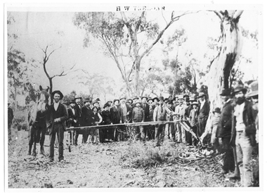
Photograph of Treloar's Foundry employees demonstrating a stump extractor, Treloar's Foundry employees demonstrating a stump extractor, between 1855 and 1894
Murray Comrie Collection. This photograph shows the Treloar Foundry employees (possibly Henry Treloar with hand resting on the stump extractor) conducting a demonstration of their tree and stump extracting device on a farm in Inglewood while a large crowd watches. Information collated by Murray Comrie: H.W. (Henry) Treloar was a native of Redruth in Cornwall, where he was born in 1811. He worked as a blacksmith in his father's Cornwall foundry and then in 1840 went to work in Cuba as a foreman smith to the Royal Santiago Copper Mining Co. Returning to England in 1851 he remained for two years just as the reports of rich Victorian goldfields began to be heard there. He brought his family to Australia in September 1853, arriving in Geelong and then working in Heidelberg for eighteen months. He returned to Geelong to set up a business but after three months was drawn to the Maryborough goldfields, then Dunolly and then Sandy Creek (as Tarnagulla was then known), arriving in March 1855. He remained in Tarnagulla until his death. He established the Foundry in Tarnagulla in 1855 and was known as the best 'mining' smith in the district. After the decline of mining he turned to production of agricultural implements and the firm built a reputation in the field, through devices such as the 'NONPARIEL' tree and stump extractor, double furrow ploughs, seed harrows and scarifiers. On 26th October 1878 the firm won three first prizes for their implements at the North Western Agricultural Show at Inglewood. The business of Treloar & Son was taken over by the James Bros in November 1894. This photograph is a reasonable copy created from an older original, owned by Miss Doris Nicholls. Copy probably made by Murray Comrie in the 1970s. Monochrome photograph of a large crowd of people watching a stump-removal demonstration in a bush setting.tarnagulla, commerce, industry, blacksmithing, smithing, foundry, businesses, treloar, james, buildings, commercial road, main street -
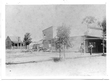
 Tarnagulla History Archive
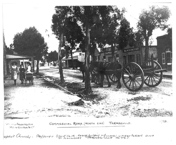
Photograph of the north end of Commercial Road, Tarnagulla, North end of Commercial Road, Tarnagulla, c. 1909
... Commercial Rd Tarnagulla goldfields Photograph of the north end ...Murray Comrie Collection. This photograph shows business on the north end of Commercial Road, Tarnagulla. From right: the brick Baptist Church (now private residence), Stafford's Blacksmith Coachbuilders and funeral/undertakers (since demolished), & Norwood's Tarnagulla Hotel. Information collated by Murray Comrie: Stafford's premises were built on land previously occupied by the stables of the George Hotel. The Stafford's building was later taken over and run by Frank McNamee. This photograph is a dark copy created from an older original. Copy probably made by Murray Comrie in the 1970s. Monochrome photograph depicting the north end of Commercial Road, Tarnagulla. A large wagon with team of horses is standing in the road. Three girls are walking down footpath at left side of image.Written on the original: 'Specially produced for Renshaw & Co' and 'Commercial Road (North End) Tarnagulla'. Written on this copy: 'Baptist Church Staffords Blacksmith Coachbuilders and funeral/undertakers, & Norwood's Tarnagulla Hotel'.tarnagulla, commerce, industry, blacksmithing, smithing, coachbuilding, businesses, stafford, norwood, mcnamee, buildings, hotels, churches, commercial road, main street -
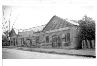 Tarnagulla History Archive
Photograph of blacksmith's shop, Tarnagulla, Blacksmith's shop, Tarnagulla, c. 1960
Murray Comrie Collection. This photograph shows the blacksmiths premises on the north end of Commercial Road, Tarnagulla. Information collated by Murray Comrie: This building was demolished in the 1970s. The first use of the site was as the George Hotel licensed to an A.B. Clay in 1858, then Waller and Robinson. Charles Waller operated his Excelsior Line of coaches from the George Hotel stables. John Ousley took over the stables for use as a blacksmith's shop. He sold out to Stafford & Sons in 1908. Staffords found the existing premises at the George Hotel too small and built this building. Frank McNamee later took over the premises and operated it for many years. This photograph is a reasonable copy created from an older original. Copy probably made by Murray Comrie in the 1970s. Monochrome photograph depicting a large run-down weatherboard building at the north end of Commercial Road, Tarnagulla. Written in a sign on right side of building: 'Blacksmiths'.tarnagulla, commerce, industry, blacksmithing, smithing, coachbuilding, businesses, stafford & sons, norwood, mcnamee, buildings, hotels, horses, stables, commercial road, main street -
 Tarnagulla History Archive
Photograph of P. Master's premises, Tarnagulla, P. Master's premises, Tarnagulla, Late 19th Century
Murray Comrie Collection. Information collated by Murray Comrie: Premises of P. Masters, cabinet-maker and funeral undertaker in Commercial Road, next to Cheetham's on the north side. Phillip Masters' Store was located in Commercial Road, opposite and south of the Victoria Theatre. This photograph is a reasonable copy created from an older original. Copy probably made by Murray Comrie in the 1970s. Monochrome photograph depicting a building with shopfront, two men standing in front. View past building to a small cottage in background.tarnagulla, commerce, shops, stores, masters, p. masters, funerals, commercial road, main street -
 Tarnagulla History Archive
Photograph of a cottage, north end of Commercial Road, Tarnagulla, Cottage, north end of Commercial Road, Tarnagulla, Late 1960s
Murray Comrie Collection. Monochrome photograph depicting a view of a cottage located at the north end of Commercial Road, Tarnagulla. tarnagulla, houses, commercial road -
 Tarnagulla History Archive
Photograph of buildings in Commercial Rd, Tarnagulla (Cash Butcher and Bakery Milk Bar), Buildings in Commercial Rd, Tarnagulla (Cash Butcher and Bakery Milk Bar), Late 1960s
Murray Comrie Collection. Good original.Monochrome photograph depicting shopfronts on Commercial Road in Tarnagulla, from a position near Poverty St, looking north. Cash Butcher at left and Bakery Milk Bar at right. A small car is parked near butcher. tarnagulla, buildings, shops, commerce -
 Tarnagulla History Archive
Photograph of Fiore Lodge, Tarnagulla, Fiore Lodge, Tarnagulla, Late 1960s
Murray Comrie Collection. Was at one time the residence of Ena Bock.Monochrome photograph depicting a house with name 'Fiore Lodge', located at the north end of Commercial Road, Tarnagulla.tarnagulla, commercial road, commerce, shopfronts, shops, businesses, bakery, food, stockfeed, grains, agriculture, doctor, surgeon, medical, medicine -
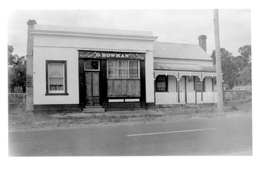 Tarnagulla History Archive
Photograph of Bowman's Bakery building, at 64 Commercial Rd, Tarnagulla, Bowman's Bakery building, Tarnagulla, Late 1960s
Murray Comrie Collection. Still located at the north end of Commercial Road, Tarnagulla.Monochrome photograph depicting building once used as G.Bowman's shopfront and adjacent dwelling in Tarnagulla.tarnagulla, commercial road, commerce, shopfronts, shops, businesses, bakery, food, stockfeed, grains, agriculture -
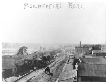 Tarnagulla History Archive
Photograph of Commercial Road, Tarnagulla, June 1866
Murray Comrie Collection. Copy of an 1866 photograph by Aimé Marchand. In June 1866, Aimé Marchand (1846-1910) made a series of fourteen photographs which were submitted to the 1866-67 Melbourne Intercolonial Exhibition, where they earned a 1st Class Honorable Mention. This is one of those fourteen images. Of French or Belgian origin and possibly formerly an assayer in California, Marchand appears to have begun his practice of photography in Tarnagulla around 1865 as an assistant to A.B. Clay. By the following year he had settled in Portland, where he opened the Royal Photographic Studio in Gawler Street. From his base in Portland he toured surrounding districts, offering portrait and view services. Little else is known about his life. He appears to have left Australia in 1878. A misprint of his name in a local directory as Annie Marchand created the misconception that he was one of only a few named women photographers in the colonies. Monochrome photograph looking north down Commercial Road, Tarnagulla from the roof of the Council Chambers. tarnagulla, views, burstall hall, council chambers, local government, commercial road, local people, residents, aimé marchand, photographers -
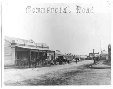 Tarnagulla History Archive
Photograph of Commercial Road, Tarnagulla, June 1866
Murray Comrie Collection. Copy of an 1866 photograph by Aimé Marchand. Thomas Comrie's Exchange Store was at south end of Commercial Road, it has since been destroyed. In June 1866, Aimé Marchand (1846-1910) made a series of fourteen photographs which were submitted to the 1866-67 Melbourne Intercolonial Exhibition, where they earned a 1st Class Honorable Mention. This is one of those fourteen images. Of French or Belgian origin and possibly formerly an assayer in California, Marchand appears to have begun his practice of photography in Tarnagulla around 1865 as an assistant to A.B. Clay. By the following year he had settled in Portland, where he opened the Royal Photographic Studio in Gawler Street. From his base in Portland he toured surrounding districts, offering portrait and view services. Little else is known about his life. He appears to have left Australia in 1878. A misprint of his name in a local directory as Annie Marchand created the misconception that he was one of only a few named women photographers in the colonies. Monochrome photograph looking north down Commercial Road, Tarnagulla from the Wayman Street corner, opposite Thomson and Comrie's Exchange Store (at south end of Commercial Road).tarnagulla, views, thomas comrie, comrie exchange store, commercial road, local people, residents, aimé marchand, photographers -
 Whitehorse Historical Society Inc.
Legal record - Correspondence, Goldfields and mineral districts of Victoria, 1985
Letter from the State Library of Victoria about location of a gold mime near Koonung Creek in Box Hill North with a reef 2 feet in thickness which yielded 1oz per ton.Letter from the State Library of Victoria about location of a gold mime near Koonung Creek in Box Hill North with a reef 2 feet in thickness which yielded 1oz per ton. Information from R. Brough Smyth 'Goldfields and mineral districts of Victoria'. - 1869Letter from the State Library of Victoria about location of a gold mime near Koonung Creek in Box Hill North with a reef 2 feet in thickness which yielded 1oz per ton. mines and mining, state library of victoria, jackson avenue, box hill north, goldmining -
 Ballarat Heritage Services
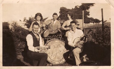
Photograph - Photograph - Black and White, Broadway Orchestra, Crossley, Late 1920s to early 1930s
Crossley's Broadway Orchestra. Three men and two women pose around a base drum belonging to the Broadway Orchestra. The man on the left holding a trumpet is Patrick Edmund Carroll of 'Hillside' Crossley, and from 1941 of Holden Street, North Fitzroy.broadway orchestra, crossley, crossly, victoria, patrick edmund carroll, band -
 Ballarat Heritage Services
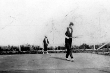
Photograph - Photograph - Black and White, Playing Tennis at St Brigid's, Crossley, c1930
Patirck Edmund Carroll farmed at Crossley, on the slopes of Tower Hill. During World War Two he moved to Melbourne, living in Holden Street, North Fitzroy, with his wife (Mary Fitzgerald) and family. Patrick Edmund Carroll of 'Hillside' Crossley plays tennis at the St Brigid's tennis courts, Crossley.patrick edmund carroll, st brigid's, crossley, crossley, tennis -
 Ballarat Heritage Services
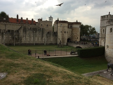
Digital photograph, Dorothy Wickham, Tower of London, 2016
The Tower of London, officially Her Majesty's Royal Palace and Fortress of the Tower of London, is a historic castle located on the north bank of the River Thames in central London. It lies within the London Borough of Tower Hamlets, separated from the eastern edge of the square mile of the City of London by the open space known as Tower Hill. It was founded towards the end of 1066 as part of the Norman Conquest of England. The White Tower, which gives the entire castle its name, was built by William the Conqueror in 1078, and was a resented symbol of oppression, inflicted upon London by the new ruling elite. The castle was used as a prison from 1100 (Ranulf Flambard) until 1952 (Kray twins),[3] although that was not its primary purpose. A grand palace early in its history, it served as a royal residence. As a whole, the Tower is a complex of several buildings set within two concentric rings of defensive walls and a moat. There were several phases of expansion, mainly under Kings Richard the Lionheart, Henry III, and Edward I in the 12th and 13th centuries. The general layout established by the late 13th century remains despite later activity on the site. The Tower of London has played a prominent role in English history. It was besieged several times, and controlling it has been important to controlling the country. The Tower has served variously as an armoury, a treasury, a menagerie, the home of the Royal Mint, a public record office, and the home of the Crown Jewels of England. From the early 14th century until the reign of Charles II, a procession would be led from the Tower to Westminster Abbey on the coronation of a monarch. In the absence of the monarch, the Constable of the Tower is in charge of the castle. This was a powerful and trusted position in the medieval period. In the late 15th century the castle was the prison of the Princes in the Tower. Under the Tudors, the Tower became used less as a royal residence, and despite attempts to refortify and repair the castle its defences lagged behind developments to deal with artillery. The peak period of the castle's use as a prison was the 16th and 17th centuries, when many figures who had fallen into disgrace, such as Elizabeth I before she became queen, Sir Walter Raleigh, and Elizabeth Throckmorton were held within its walls. This use has led to the phrase "sent to the Tower". Despite its enduring reputation as a place of torture and death, popularised by 16th-century religious propagandists and 19th-century writers, only seven people were executed within the Tower before the World Wars of the 20th century. Executions were more commonly held on the notorious Tower Hill to the north of the castle, with 112 occurring there over a 400-year period. In the latter half of the 19th century, institutions such as the Royal Mint moved out of the castle to other locations, leaving many buildings empty. Anthony Salvin and John Taylor took the opportunity to restore the Tower to what was felt to be its medieval appearance, clearing out many of the vacant post-medieval structures. In the First and Second World Wars, the Tower was again used as a prison, and witnessed the executions of 12 men for espionage. After the Second World War, damage caused during the Blitz was repaired, and the castle reopened to the public. Today the Tower of London is one of the country's most popular tourist attractions. Under the ceremonial charge of the Constable of the Tower, it is cared for by the charity Historic Royal Palaces and is protected as a World Heritage Site.(Wikipedia) A World Heritage Site is a landmark which has been officially recognized by the United Nations, specifically by UNESCO. Sites are selected on the basis of having cultural, historical, scientific or some other form of significance, and they are legally protected by international treaties. UNESCO regards these sites as being important to the collective interests of humanity. More specifically, a World Heritage Site is an already classified landmark on the earth, which by way of being unique in some respect as a geographically and historically identifiable piece is of special cultural or physical significance (such as either due to hosting an ancient ruins or some historical structure, building, city, complex, desert, forest, island, lake, monument, or mountain) and symbolizes a remarkable footprint of extreme human endeavour often coupled with some act of indisputable accomplishment of humanity which then serves as a surviving evidence of its intellectual existence on the planet. And with an ignoble intent of its practical conservation for posterity, but which otherwise could be subject to inherent risk of endangerment from human or animal trespassing, owing to unmonitored/uncontrolled/unrestricted nature of access or threat by natural or accelerated extinction owing to local administrative negligence, hence it would have been listed and demarcated by the United Nations Educational, Scientific and Cultural Organization (UNESCO) to have been identified or recognised and officially christened and internationally elevated through multilateral declaration by UNESCO as a universally protected zone. [1] The list is maintained by the international World Heritage Programme administered by the UNESCO World Heritage Committee, composed of 21 UNESCO member states which are elected by the General Assembly. (Wikipedia)The Tower of London is a UNESCO world heritage site.tower of london -
 Ballarat Heritage Services
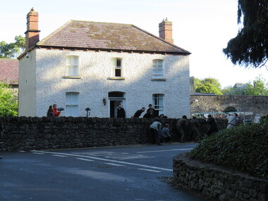
Digital Photograph, Dorothy Wickham, Filming Fingal's Finest Day, Malahide Castle, 2016, 09/2016
Generations of the Talbot family have called Malahide Castle home. They played significant roles in Irish political and social life. Set in 260 acres the castle is only 10 minutes from Dublin airport. https://www.malahidecastleandgardens.ie/ According to wikipedia See https://en.wikipedia.org/wiki/Easter_Rising#Fingal In Fingal (or north County Dublin), about 60 Volunteers mobilised near Swords. They belonged to the 5th Battalion of the Dublin Brigade (also known as the Fingal Battalion), and were led by Thomas Ashe and his second in command, Richard Mulcahy. Unlike the rebels elsewhere, the Fingal Battalion successfully employed guerrilla tactics. They set up camp and Ashe split the battalion into four sections: three would undertake operations while the fourth was kept in reserve, guarding camp and foraging for food. The Volunteers moved against the RIC barracks in Swords, Donabate and Garristown, forcing the RIC to surrender and seizing all the weapons. They also damaged railway lines and cut telegraph wires. The railway line at Blanchardstown was bombed to prevent a troop train reaching Dublin. This derailed a cattle train, which had been sent ahead of the troop train. The only large-scale engagement of the Rising, outside Dublin city, was at Ashbourne. On Friday, about 35 Fingal Volunteers surrounded the Ashbourne RIC barracks and called on it to surrender, but the RIC responded with a volley of gunfire. A firefight followed, and the RIC surrendered after the Volunteers attacked the building with a homemade grenade. Before the surrender could be taken, up to sixty RIC men arrived in a convoy, sparking a five-hour gun battle, in which eight RIC men were killed and 18 wounded. Two Volunteers were also killed and five wounded, and a civilian was fatally shot. The RIC surrendered and were disarmed. Ashe let them go after warning them not to fight against the Irish Republic again. Ashe's men camped at Kilsalaghan near Dublin until they received orders to surrender on Saturday. The Fingal Battalion's tactics during the Rising foreshadowed those of the IRA during the War of Independence that followed. Volunteer contingents also mobilised nearby in counties Meath and Louth, but proved unable to link up with the North Dublin unit until after it had surrendered. In County Louth, Volunteers shot dead an RIC man near the village of Castlebellingham on 24 April, in an incident in which 15 RIC men were also taken prisoner.filming fingal's finest day, malahide castle, ireland -
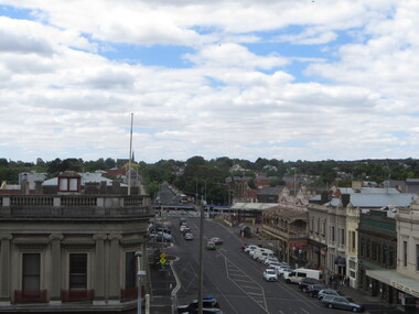 Ballarat Heritage Services
Photograph - Photograph - Colour, Ballarat From the Regent Cinema, Lydiard Street North, Ballarat, 2015, 27/12/2016
Lydiard Street is known as an axcellent example of Victorian architecture.Various views of Ballarat's Lydiard Street Northballarat, lydiard street north, buildings, aerial, birds eye, sebastions, regent cinema -
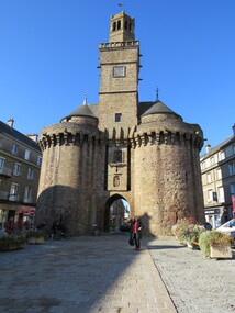 Ballarat Heritage Services
Digital Photograph, Old Gateway, Vire, France, October 2016
The Old Gateway or the Saint-Sauveur Gateway (13th Century). After the old regime it had, for some time, served as a Town Hall. In august 1944, the US troops, eager to facilitate truck traffic provisioning the frontline, wanted to blow up this tower. It was saved by the energetic intervention of Mayor Andre Halbout. The town plan of 1946 rerouted Chaussee Street, which now passes to the north of the tower. The south tower, its twin, disappeared in 1788.Colour photograph of the Old Gateway, Vire, Franceold gateway, vire, france -
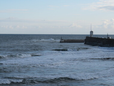 Ballarat Heritage Services
Digital photograph, North Sea, SeaHouses, UK
... Office goldfields Digital photograph North Sea, SeaHouses, UK ... -
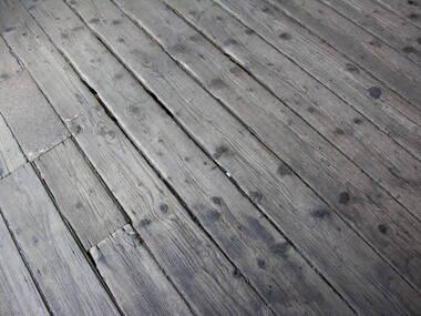 Ballarat Heritage Services
Photograph - Photograph - Colour, Timber Floor on the North Platform, Ballarat Railway Precinct, 2017
Colour photograph of fwell worn timber floor boards at the Ballarat Railway Station. ballarat railway station, floor boards -
 Ballarat Heritage Services
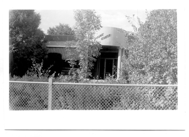
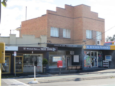
Photograph, Clare Gervasoni, North Kew Village Shopping Centre, 2017, 10/07/2017
... Office goldfields Photograph North Kew Village Shopping Centre ...North Kew Village Shopping Centre, Willsmere Roadnorth kew newsagency, north kew village, newsagent, willsmere road, kew north, martin solomons -
 Ballarat Heritage Services
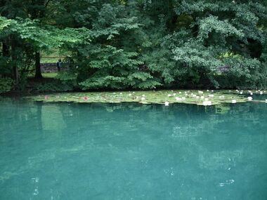
Digital photograph, Lake Bled
The lake is of mixed glacial and tectonic origin. It is 2,120 m (6,960 ft) long and 1,380 m (4,530 ft) wide, with a maximum depth of 29.5 m (97 ft), and it has a small island. The lake lies in a picturesque environment, surrounded by mountains and forests. Medieval Bled Castle stands above the lake on the north shore. The World Rowing Championships in 1966, 1979, 1989, and 2011 were held at Lake Bled.Colour photograph of Lake Bled.lake bled -
 Ballarat Heritage Services
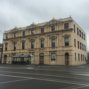
Photograph - Colour, Clare Gervasoni, Ludbrook House, Ballarat, 2016, 30/07/2016
Colour photography of a double storey building in Lydiard Street North, Ballarat.ludbrook house, lydiard street, ballarat -
Ballarat Heritage Services
Photograph, Birthday Party, 1969, c1969
Five girls celebrate the birthday of Clare Gervasoni at her home, 93 Willsmere Road, North Kew (behind North Kew Newsagency). A cake featurers seven lit candles, there are Marchants Lemonade bottles and a bowl of jelly on the table. Most of the girls wear the uniform of St Anne's East Kew, and an apron. Left to right: ? Martina ?, Clare Gervasoni, Brigid DeNeefe, Yvonne Brosolo (cut off) birthday, clare gervasoni, brigid deneefe, st anne's east kew uniform -
 Ballarat Heritage Services
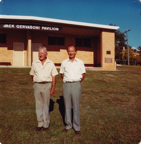
Digital copy, Opening of Jack Gervasoni Pavilion at Willsmere Park by Premier of Victoria Rupert (Dick) Hamer, 28/07/1979
Jack Gervasoni was a newsagent at 93 Willsmere Rd Kew for 17 years and a City of kew councillor for 9 years. The naming of the pavilion honoured his work within the community, particlularly with youth and recreation. Colour photographs of the Gervasoni Pavilion, North Kew. .1) John Hogan (Jack) Gervasoni and his father, Gus Gervasoni, in front of the Jack Gervasoni Pavilion .2) Cr Allan Hitchinson, Premier Rupert Hamer, Jack Gervasoni and Kew Town Clerk Les Fell beside as sign at the newly opened Jack Gervasoni Pavilion.kew, sport, facility, ground, dick hamer, jack gervasoni, gus gervasoni, pavilion, alan hutchinson, les fell, willsmere park, jack gervasoni pavilion