Showing 2286 items matching " parish."
-
 Eltham District Historical Society Inc
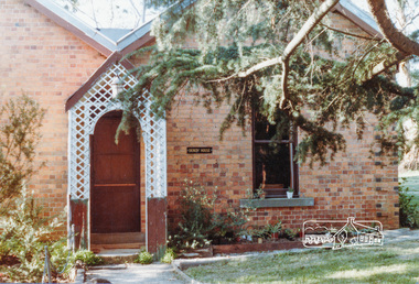
Photograph, Dendy House, Pitt Street Eltham
Colour photograph of Dendy House, original St. Margaret's vicarage now Parish Centre, Pitt Street, Eltham.dendy house, st margarets church, pitt street, eltham, churches -
 Ringwood and District Historical Society
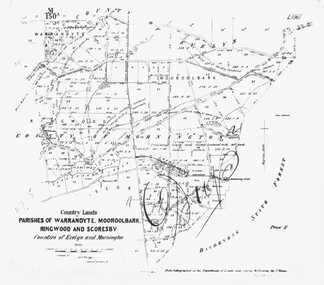
Photograph, Map-Parishes of Warrandyte, Mooroolbark, Ringwood and Scoresby. 1870
Photograph of map "Country Lands - Parishes of Warrandyte, Mooroolbark, Ringwood and Scoresby - Counties of Evelyn and Mornington" dated 1870. -
 Bendigo Historical Society Inc.
Map - KANGAROO FLAT SUBDIVISION, 26/11/1900
Map: Plan of Subdivision at Kangaroo flat, Parish of Sandhurst, County of Bendigo ( number 149 in Map Cupboard 1)map, bendigo, parish plan, kangaroo flat, parish of sandhurst, county of bendigo -
Bendigo Historical Society Inc.
Map - EAGLEHAWK (PART), 22/01/1882
Map: Parish plan showing area Eastward from Lightning Hill ( number 205 in Map Cupboard 1)map, bendigo, parish plan, eaglehawk, lightning hill -
Bendigo Historical Society Inc.
Map - NERRING. SHEET ?, Circa 1894
Map: Nerring, Part ( number unreadable), County of Bendigo. Parish plan ( number 190 in Map Cupboard 1)map, bendigo, parish plan, nerring -
Bendigo Historical Society Inc.
Map - RAVENSWOOD, April 6th 1872
Map: Township of Ravenswood. Parish plan, has a 1913 calendar as a backing (number 266 in map cupboard 1)map, bendigo, township, ravenswood -
Bendigo Historical Society Inc.
Map - PORTION OF SANDHURST, 27/01/1877
Map: Hand draughted parish plan, showing a portion of the City of Sandhurst ( number 225 in Map Cupboard 1)map, bendigo, parish plan, sandhurst -
Bendigo Historical Society Inc.
Map - SANDHURST (PART), Circa 1880's
Map: Parish plan sowing an area along Specimen Hill Rd. ( number 211 in Map Cupboard 1)map, bendigo, parish plan, specimen hill rd. sandhurst , bendigo -
Bendigo Historical Society Inc.
Map - TARNAGULLA SHEET 1, Examined 25/08/1926
Map: Tarnagulla Sheet 1, Counties of Gladstone and Bendigo. Parish plan (number 304 in map cupboard 1)map, gladstone, parish plan, tarnagulla -
 Whitehorse Historical Society Inc.
Map - Nunawading scaled Map, Nunawading, 1864
Parish plan of Nunawading, Lands Department, 1864, showing names of first purchasers of land. Copy also at NP215.parish of nunawading, land settlement, maps -
Bendigo Historical Society Inc.
Map - BENDIGO PARISH PLAN
BHS CollectionBendigo Parish Plan Central Bendigo. Canvas with Canvas typed edges. Taken from George Black's maps -
 Ringwood and District Historical Society
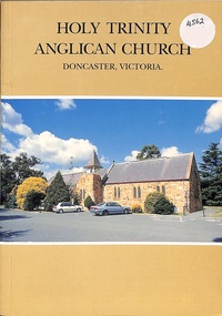
Book, Holy Trinity Anglican Church Doncaster, 1997
The History of the Parish of Holy Trinity Anglican Church Doncaster and includes many of the early Ringwood families Published 1997 -
Bendigo Historical Society Inc.
Map - CAMPBELL COLLECTION: BENDIGO AND DISTRICT MAPS
Map. Whirrakee, Parish of Whirrakee. Total area of map 4419 acres. Scale 20 chains to 1 inch. 23 allotments are sold, Eucalypt oil distillery on lower portion of map. Prepared in W.P.B. from Assessor's plan and Parish Plan. (number 350 in map cupboard 1)map, bendigo, allotments -
Bendigo Historical Society Inc.
Map - CAMPBELL COLLECTION: BENDIGO AND DISTRICT MAPS, 22-3-29
Map. Marong, Parishes of Marong, Lockwood and Mandurang, Scale 20 chains to 1 inch, Total area 5106 acres. Crusoe Reservoir & Viaduct and water race. Compiled in W.P.B. fro Field Survey and Parish Plans. B.W.L.22-3-29 (number 389 in map cupboard 1)B.W.L.map, bendigo, allotments -
Tatura Irrigation & Wartime Camps Museum
Book, Damien Finlayson, Time to Reflect. The centenary of Sacred Heart Church : Tatura 1912 - 2012
The centenary of Sacred Heart Church Tatura: 1912 - 2012Cover of book shows the alter and stained glass windows of the Church. There is a copy of the Last Supper on the back cover. Includes photographs of past priests and scenes of the church. 33 pages.The Forward : written by the Parish priest Fr Michael Morley 18/10/2012. A page of "Acknowledgements" is also included.catholic church history -
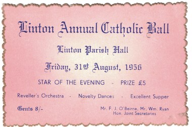 Linton and District Historical Society Inc
Ticket, Linton Annual Catholic Ball, 1956, 1956
Pink card, gold edge, blue printing. Ticket for Linton Annual Catholic Ball, held 31st August 1956.Text: " Linton Annual Catholic Ball / Linton Parish Hall / Friday, 31st August, 1956 / STAR OF THE EVENING. "linton catholic church, events, balls, f. j. o'beirne, william ryan -
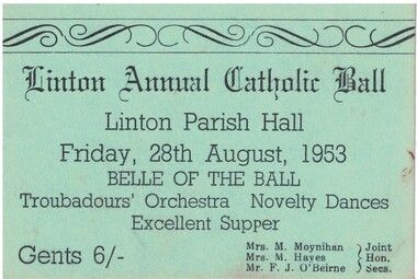 Linton and District Historical Society Inc
Ticket, Linton Annual Catholic Ball, 1953, 1953
Green card, black printing. Ticket for Linton Annual Catholic Ball, held 28th August 1953.Text: " Linton Annual Catholic Ball / Linton Parish Hall / Friday, 28th August, 1953 / BELLE OF THE BALL. "linton catholic church, events, balls, mrs m. moynihan, mrs m. hayes, f. j. o'beirne -
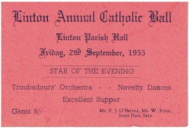 Linton and District Historical Society Inc
Ticket, Linton Annual Catholic Ball, 1955, 1955
Orange card, black printing. Ticket for Linton Annual Catholic Ball, held 2nd September 1955.Text: " Linton Annual Catholic Ball /Linton Parish Hall / Friday, 2nd September, 1955 / STAR OF THE EVENING. "linton catholic church, events, balls, f. j. o'beirne, w. ryan -
 Bendigo Historical Society Inc.
Map - JACK FLYNN COLLECTION: COUNTY OF GLADSTONE, 1934
Map: County of Gladstone, map sheet showing the whole of the County and the Parishes within. Scale 2 Miles to 1 inch.Engraved at the Department of Lands and Survey Melbourne. 1958. By Authority of W.M. Houston, Government Printermap, gladstone, parish plan, gladstone -
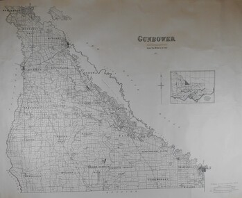 Bendigo Historical Society Inc.
Map - JACK FLYNN COLLECTION: COUNTY OF GUNBOWER, 1935
Map; County of Gunbower. Sheet containing the whole of the County, showing parishes within. Scale 2 Miles to 1 inch.map, gunbower, parish plan, gunbower -
Bendigo Historical Society Inc.
Map - PART PARISHES OF SANDHURST MARONG AND NERRING, No date visible
Map: Section of a Parish plan of Bendigo, covering Ironbark, Eaglehawk and Myers Flat ( number 145 in Map Cupboard 1)map, bendigo, city streets, parish of sandhurst, parish of marong, parish of nerring, ironbark, eaglehawk, myers flat -
Bendigo Historical Society Inc.
Map - BENDIGO IRRIGATION SETTLEMENT, 12/02/1908
Map: Plan of Bendigo Irrigation Settlement, Parishes of Sandhurst and Wellsford, County of Bendigo ( number 160 in Map Cupboard 1)map, bendigo, irrigation settlement, bendigo irrigation settlement, parishes of sandhurst and wellsford, county of bendigo -
Bendigo Historical Society Inc.
Map - TARNAGULLA (PARTS), Circa 1880's
Map: Compilation of 3 hand draughted parish plans showing portions of Tarnagulla (number 261 in map cupboard 1)map, parish plan, tarnagulla -
Bendigo Historical Society Inc.
Map - SANDHURST (PART), Circa 1880's
Map: Parish plan showing the area Specimen Hill Road and Inglewood St. ( number 222 in Map Cupboard 1)map, bendigo, parish plan, specimen hill rd. inglewood st. -
Whitehorse Historical Society Inc.
Document, Crown Portion 119, c1970
Description of transfers of ownership of Crown Portion 119, Parish of Nunawading, 1858 - 1960, bounded by Whitehorse and Mitcham Roads, Mitcham.morgan, robert rowland, the church of england trusts corporation, mitcham, whitehorse road, mitcham, mitcham road, mitcham, peel street, mitcham, ormond avenue, mitcham, edward street, mitcham, christ church anglican church, mitcham, churches -
Whitehorse Historical Society Inc.
Document, Elizabeth Jane Creswell, 1833
Extract from register of Parish Church of Mitcham, County of Surrey.Extract from register of Parish Church of Mitcham, County of Surrey, of baptism of Elizabeth Jane Creswell, 24/11/1833.Extract from register of Parish Church of Mitcham, County of Surrey. pioneers, creswell, elizabeth jane, creswell, william, creswell, sarah, mitcham, surrey, england -
Whitehorse Historical Society Inc.
Document, Title to 59 Mount Pleasant Road Nunawading, 1871 - 1992
Copies of Title documents for Lot 3, Plan of Subdivision 18705 for Section 117b, Parish of Nunawading from 1871 to 1992.Copies of Title documents for Lot 3, Plan of Subdivision 18705 for Section 117b, Parish of Nunawading from 1871 to 1992.Copies of Title documents for Lot 3, Plan of Subdivision 18705 for Section 117b, Parish of Nunawading from 1871 to 1992.mount pleasant road, nunawading no. 59, land titles, jones, dan, jones, anne -
Bendigo Historical Society Inc.
Book - LYDIA CHANCELLOR COLLECTION: HISTORY OF THE PARISH CHURCH OF ST PAUL 'THE FIRST HUNDRED YEARS', 1968
LYDIA CHANCELLOR COLLECTION: HISTORY OF THE PARISH CHURCH OF ST PAUL 'THE FIRST HUNDRED YEARS' plus programmes 1868-1968bendigo, history, bendigo churches -
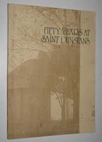 Camberwell Historical Society
Book, Vestry of St. Dunstan's Church of England, Fifty Years at Saint Dunstan's, 1976
A history of the Anglican parish of Saint Dunstan, Camberwell 1926-1976. Published by the Vestry of St Dunstan's Church of England, 1976.camberwell, australia, history, churches -
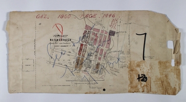 Bendigo Historical Society Inc.
Map - NEILBOROUGH RAVENSWOOD, October 21 1859
Map:Township of Neilborough, Elysian Flat, near Sandhurst,County unnamed. Parish plan. Backing is a part of Ravenswood Township map.map, bendigo, neilborough, elysian flat, ravenswood