Showing 110498 items matching " roads"
-
 Eltham District Historical Society Inc
Slide, Adam Crescent, Montmorency, c. Feb. 1981
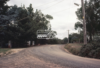
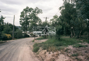
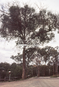
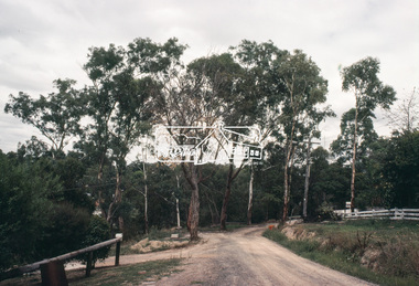
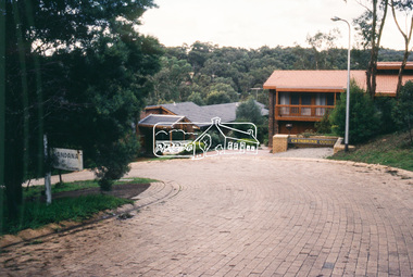
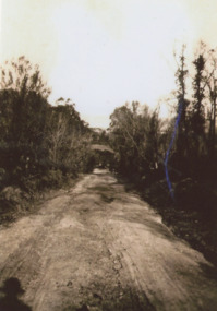
... roads ...One of a series of images of road infrastructure focussed on Adam Crescent in Montmorency taken by Eltham Shire Council Planning and Engineering officers. They provide perspective of the changes in housing styles and road development that began sweeping in from the mid 1970s with increasing urbanisation of what was once more outlying suburbs and regions. All images have been identified with GPS though house numbers have changed35 mm colour positive transparency (1 of 21) Mount - Kodak Kodachrome CardProcessed Feb 1981adam crescent, infrastructure, montmorency, roads -
 Eltham District Historical Society Inc
Slide, Adam Crescent, Montmorency, c. Feb. 1981
... roads ...One of a series of images of road infrastructure focussed on Adam Crescent in Montmorency taken by Eltham Shire Council Planning and Engineering officers. They provide perspective of the changes in housing styles and road development that began sweeping in from the mid 1970s with increasing urbanisation of what was once more outlying suburbs and regions. All images have been identified with GPS though house numbers have changed35 mm colour positive transparency (1 of 21) Mount - Kodak Kodachrome CardProcessed Feb 1981adam crescent, infrastructure, montmorency, roads -
 Eltham District Historical Society Inc
Slide - Photograph, Main Yarra Trail, Lower Plenty, c.Aug. 1990
... roads ...Part of a presentation, "Roads and Byways of the Shire of Eltham", by Russell Yeoman to the 12 September 1990 Society meeting. Slides shown included copies of old photos and recent images ranging from the suburban streets of Eltham and Montmorency to the mountain roads of Kinglake. In the byways category are views of some iof the Shire's bicycle paths including then recently completed sections of the Main Yarra Trail at Lower Plenty.35mm colour positive transparency (1 of 37) Mount - Agfachrome Agfa CS System black 8 dotsinfrastructure, bonds road, lower plenty, roads -
 Eltham District Historical Society Inc
Slide - Photograph, Grand Boulevard, Montmorency, c.Aug. 1990
... roads ...Part of a presentation, "Roads and Byways of the Shire of Eltham", by Russell Yeoman to the 12 September 1990 Society meeting. Slides shown included copies of old photos and recent images ranging from the suburban streets of Eltham and Montmorency to the mountain roads of Kinglake. In the byways category are views of some iof the Shire's bicycle paths including then recently completed sections of the Main Yarra Trail at Lower Plenty.35mm colour positive transparency (1 of 37) Mount - Agfachrome Agfa CS System black 8 dotsinfrastructure, roads, grand boulevard, montmorency -
 Eltham District Historical Society Inc
Slide - Photograph, Eltham-Yarra Glen Road, Research, c.Aug. 1990
... roads ...Part of a presentation, "Roads and Byways of the Shire of Eltham", by Russell Yeoman to the 12 September 1990 Society meeting. Slides shown included copies of old photos and recent images ranging from the suburban streets of Eltham and Montmorency to the mountain roads of Kinglake. In the byways category are views of some iof the Shire's bicycle paths including then recently completed sections of the Main Yarra Trail at Lower Plenty.35mm colour positive transparency (1 of 37) Mount - Agfachrome Agfa CS System black 8 dotsinfrastructure, roads, research (vic.), eltham-yarra glen road -
 Eltham District Historical Society Inc
Slide - Photograph, Catherine Court, Eltham, c.Aug. 1990
... roads ...Part of a presentation, "Roads and Byways of the Shire of Eltham", by Russell Yeoman to the 12 September 1990 Society meeting. Slides shown included copies of old photos and recent images ranging from the suburban streets of Eltham and Montmorency to the mountain roads of Kinglake. In the byways category are views of some iof the Shire's bicycle paths including then recently completed sections of the Main Yarra Trail at Lower Plenty.35mm colour positive transparency (1 of 37) Mount - Agfachrome Agfa CS System black 8 dotsinfrastructure, roads, catherine court, eltham -
 Mt Dandenong & District Historical Society Inc.
Photograph
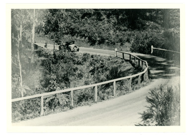
An old fashioned car can be seen pulling away from a bend on the new CRB Road at Wallaby Gully (now Mt Dandenong Tourist Road). Wallaby Gully is near the Mt Dandenong kindergarten. The year is c1926.Black and white photograph showing a car rounding a bend on a road surrounded by bush and fenced with a wooden rail fence.crb road, kindergarten, car, mt dandenong tourist road, wallaby gully -
 National Wool Museum
Book, Machinery
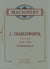
"Machinery" - J. Charlesworth, Union Iron Works, Colne Road, Huddersfield, c.1930.Book: "Machinery" - J. Charlesworth, Union Iron Works, Colne Road, Huddersfield, c.1930.textile machinery, j. charlesworth -
 Whitehorse Historical Society Inc.
Photograph, Railway crossing on Springvale Road, 1/06/2009
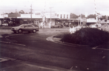
One of a collection of photographs taken of the Nunawading Railway Station prior to the lowering of the railway line and building of the new railway station on the western side of Springvale Road so that the Springvale Road Rail Crossing can be eliminated.Black & white photograph of the precinct surrounding the Nunawading Station and the Springvale Road Railway crossing. This photograph is the railway crossing with Springvale Road, Nunawading, taken from the north west corner looking over crossing to some of the Nunawading shops. See NP 3545 to NP3567 for the complete set of photographsnunawading railway station, springvale road nunawading, redevelopment of railway line/springvale road., nunawading recreation centre -
 Whitehorse Historical Society Inc.
Document, Forest Hill, c2004
Manuscript and typescript copy of description of life in Forest Hill in the 1940's and early 1950's.Manuscript and typescript copy of description of life in Forest Hill in the 1940's and early 1950's. The author's family operated a general store on the corner of Springvale and Canterbury Roads and lived across the road. Forest Hill was just ending its period as a rural community. Ref:: NP2401, NP2402, NP2403.Manuscript and typescript copy of description of life in Forest Hill in the 1940's and early 1950's. forest hill, richards, chris -
 Lakes Entrance Historical Society
Photograph - Palmers Rd. Lakes Entrance 1927, Edie Jemmeson, 1927 c
This photograph was used in the 150 year Lakes Entrance 1858 to 2008 display as the before picture paired with colour photograph number 03727.1 as the after picture size 10 x 15 cm road now paved with many buildings showingHistoricBlack and white photograph of Palmers Road looking south towards the sand dunes and ocean, teatree along the side of the road photographers shadow in foreground, Lakes Entrance Victoriatopography, sand dunes -
 Kew Historical Society Inc
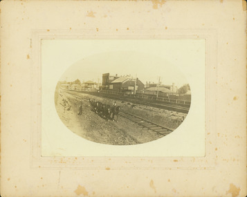
Photograph - Regrading the Camberwell Railway Line near Burke Road, E.J. Dower, 1915
One of a series of photographs, taken by Edgar James Dower in the second decade of the twentieth century. Born and raised in Olinda, his family later moved to Surrey Hills. He worked as an adult as a clerk in the city office of the Metropolitan Gas Company, and in his role as a 'collector', he was able to photograph scenes including the construction of tramlines, railways and associated buildings in Kew, Hawthorn, Camberwell and Surrey Hills. Later he established a real estate agency with his brother - the E.J. Dower Real Estate Agency, Dandenong Office.The image is an historically significant record of the development of transport infrastructure which was used to connect Victorians in the first two decades of the twentieth century. This development resulted from increases in population and the consequent extension of Melbourne's suburbs. The photographs, both individually and collectively, richly detail the labour of workers and the tools and machinery used to create and extend Melbourne's public transport network in the years preceding and during World War 1.Digital copy of an original oval mounted photograph depicting workers regrading the Camberwell Railway line following the demolition of the original Camberwell Railway Station. The level crossing gates at Burke Road can be seen in the distance. Named buildings include The Assembly Hall at right.Verso: "1915 / Regrading Camberwell railway line, near Burke Road / Taken by E.J.Dower."theme -- connecting victorians by transport and communications, theme - camberwell railway station, theme - travelling by train -
 Ringwood and District Historical Society
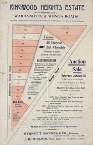
Flyer, Land Auction Sale Advertisement - Ringwood Heights Estate, Ringwood, Victoria - circa 1923
Advertisement for land and weatherboard villa auction sale on Saturday, January 13 (1923?) - Ringwood Heights Estate, corner Warrandyte and Wonga Roads, North Ringwood, with terms of sale, summary of local features and services, and map showing layout of subdivisionSubdivision includes Wonga Road and Anderson's Creek Road (later Warrandyte Road). Agents - Sydney T. Haynes & Co., Auctioneers, 60 Queen Street, Melbourne. Phone Central 3400; J.B. McAlpin, Estate Agent, Opposite Ringwood Station. Auction in the Trust Estate of J.J. Parker, instructed by the Equity Trustees Co. Ltd. 85 Queen Street, Melbourne. -
 Eltham District Historical Society Inc
Slide - Photograph, Main Road at Bridge Street, Eltham, c.May 1988
... Roads ...Main Road at Bridge Street, Eltham, c.May 198835mm colour positive transparency (1 of 36) Mount - Kodak KodachromeProcess Date MAY 88Mbridge street, eltham, infrastructure, main road, roads -
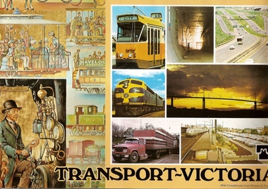 Greensborough Historical Society
Book, Transport in Victoria, 1980s
... roads ...Each of these booklets details the history, changes and upgrades to transport in Victoria in the early 1980s and explains the role af government authorities such as the Country Roads Board. Item 707c describes the Melbourne Freight Terminal between Spencer Street and Footscray Road.An historical look at the development of transport in Victoria.A collection of 3 booklets on transport in Victoria. Item 707a: 16 pages, colour illustrations. Item 707b: 20 pages, colour illustrations.Item 707c: 8 pages, black and white illustrations (20 x 14.5 cm). railways, transport, victoria, trams, roads -
 Mt Dandenong & District Historical Society Inc.
Photograph, Walker's LOT 2
Harry Walker's property would have been run by his son William in 1922. When the CRB Road cut through the property William planted plum trees on the opposite side. These are visible in this photo. An extensive raspberry crop is in the foreground. The building over the road on the left hand side is the corn and produce store built by Edward John Price (son of Edward Joseph Price) to capitalise on the CRB Road cutting through the Price farm. John Lundy-Clarke grew up in the Kalorama/Mt Dandenong area and later in life (1972-74) began to write a comprehensive history of the area working from an original settlement map in an effort to cover all areas.Small black and white postcard showing a crop in foreground with a house to the right. A road passes through the centre with a house on the left on the opposite side of the road. A view to the ranges in the distance. A handwritten description on reverse by John Lundy-Clarke.View at Kalorama. View over LOT 2 (Walkers) 1922.harry walker, william walker, crb road, raspberry, edward john price, edward joseph price, produce store, store -
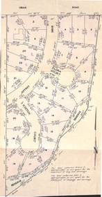
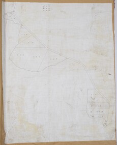 Bacchus Marsh & District Historical Society
Map, Lerderderg Gorge Road Goodmans Creek to Gisborne Road
The date of this map and its purpose has not been established. It was possibly produced to indicate landholders who were impacted by works along the Lerderderg Gorge Road. A single page paper map showing various blocks of land along the route of the Lerderderg Gorge Road near Bacchus Marsh from Goodmans Creek to the point where the road joins with Gisborne Road. The map is pasted into a bound volume containing 76 maps or plans in total. High resolution digital image stored on BMDHS computer network. bacchus marsh victoria maps, lerderderg gorge road bacchus marsh maps -
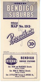 Bendigo Historical Society Inc.
Map - Three Road Maps of Bendigo, 1962
George Robert Broadbent (1863-1947), cyclist and map publisher, was born on 3 November 1863 at Ashby near Geelong, Victoria, son of George Adam Broadbent, Lancashire-born draper, and his wife Elizabeth, née Ruffhead. When the family moved to North Melbourne Broadbent attended the Errol Street school, followed his father's trade, and became an early cycling and cycle-racing enthusiast. At various times Broadbent held most Victorian and Australian road records, and two of his performances on solid tyres—203 miles (327 km) in 24 hours on a penny farthing, and 100 miles (161 km) in 6 hours 20 minutes on a 'safety' bicycle—were never bettered. He established records for all distances between 130 and 220 miles (209 and 354 km), and for all times between 8 and 12 hours, at the Exhibition Grounds track in May 1894, and road records for 50 and 100 miles (80 and 161 km) in October 1896. The Australian Cyclist acknowledged him 'the finest road rider that Australia has ever produced'. A foundation councillor of the League of Victorian Wheelmen in October 1893, Broadbent contested the first Warrnambool-Melbourne race in 1895, and was active in the Good Roads Movement. Next year he issued a road map of Victoria, 'prepared … after some sixteen years riding and touring in all parts of the Colony', which indicated general topography, distances, and roads classified as 'good', 'fair' or 'ridden with difficulty'. It was to become Victoria's standard map, and the basis of a continuous publishing programme by Broadbent's Official Road Guides Co.Three Road Maps of Bendigo, Bendigo and Suburbs, Bendigo and Eaglehawk. Two fold out maps printed in colour and produced by Broadbent's Road Maps Pty. Ltd. 475 Collins Street Melbourne. One map printed by Bolton's Bendigo.history, bolton's, bendio broadbent maps -
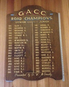 Geelong Cycling Club
Memorabilia - Honour Board, 1945-1963
This shield was prepared for the Geelong Amateur Cycling Club to record the winners of the Club's Junior and Senior Road Championships over the years 1945 to 1963.This shield records in perpetuity the winners of the the Junior and Senior Road Championships over the years 1945 to 1963.Large dark stained timber shield with gold embossed engravings of winners of the G.A.C.C. Road Championships for Senior and Junior Club members during the years 1945 to 1963."G.A.C.C./Road Championships/Senior/1945 Allen C/1946 Mockridge R/ 1947 Mockridge R/ 1948 Macauley L/ 1949 Stewart WS/ 1950 Orr C/ 1951 McMurrich B/ 1952 Benson M/ 1953 Penn RL/ 1954 Martin N/ 1955 Smith E/ 1956 Elliott J/ 1957 Elliott J/ 1958 Hine RJ/ 1959 Hine RJ/ 1960 Hine RJ/ 1961 Hine RJ/ 1962 Hine RJ/ 1963 Finn R/ Junior/1945 Gogell H/ 1946 D Richards/ 1947 H Stonehouse/ 1948 McMurrich B/ 1949 Norris W/ 1950 Gogoll E/ 1951 Penn RL/ 1952 Penn RL/ 1953 Meaney G/ 1954 Meaney G/ 1955 Elliott J/ 1956 Whitside A/ 1957 Hine RJ/ 1958 Gardiner W/ 1959 Clark N/ 1960 Stokely J/ 1961 Murrell B/ 1962 Murrell B/ 1963 Madden J/ Presented by BW McConachy"g.a.c.c.; road championships; allen c; mockridge r; macauley l; stewart ws; orr c; mcmurrich b; benson m; penn rl; martin n; smith e; elliott j; hine rj; finn r; richards d; stonehouse h; norris w; gogoll e; meaney g; whitside a; gardiner w; clark n; stokely j; murrell b; madden j; mcconachy bw;, geelong amateur cycling club -
 Whitehorse Historical Society Inc.
Pamphlet - Advertising brochure, Arlington Estate
Estate Agent's advertising brochure for Arlington Estate,Estate Agent's advertising brochure for Arlington Estate, Blackburn including Molleton Street. Baldwin Street and Canterbury Road.Estate Agent's advertising brochure for Arlington Estate,arlington estate, blackburn, molleton street, canterbury road, baldwin street, land subdivision -
Whitehorse Historical Society Inc.
Article, Traffic works, 1/06/1994 12:00:00 AM
Nunawading Gazette article dated 8 June 1994.Nunawading Gazette article dated 8 June 1994 about traffic works at Blackburn and Railway Roads intersection.Nunawading Gazette article dated 8 June 1994. roads and streets, blackburn road, blackburn, railway road, blackburn -
Whitehorse Historical Society Inc.
Article, Lasting memories, 2012
50th Anniversary reunion of the Mitcham and Heatherwood Special Schools50th Anniversary reunion of the Mitcham and Heatherwood Special Schools on 12 October 2012 at 370 Springvale Road Donvale.50th Anniversary reunion of the Mitcham and Heatherwood Special Schools heatherwood special school, mitcham special school -
 Ringwood and District Historical Society
Document - Folder, Kinton Court Estate Subdivision, Ringwood, Victoria - 1975
Manilla folder containing plan of residential subdivision, with price list and summary of services available. Subdivision includes Oban Road, Jeffrey Drive, Flora Court and Kinton Court. Timbered land - 22 sewered allotments. Agents - C.E. Carter & Son RESI., 122 Whitehorse Road, Ringwood (Phone) 8706211. -
Whitehorse Historical Society Inc.
Document, 520 Mitcham Road, 2005
Papers relating to objections to development of 520-528 Mitcham Road Mitcham.Papers relating to objections to development of 520-528 Mitcham Road Mitcham. Includes: statement by Neil Edwin Kerby & Margaret Anne Kerby; Title searches for 449 Mitcham Road Mitcham and adjacent properties; plan of 1906 subdivision; ASIC extract of development company organisational details; aerial photos of the area; photographs of nearby properties and of Mitcham Road streetscapes and list of Mitcham objectors. CD copy at NP3771Papers relating to objections to development of 520-528 Mitcham Road Mitcham. mitcham road mitcham, nos. 520-528, kerby, neil edwin, kerby, margaret anne, mitcham road mitcham no. 449, 520 mitcham road pty ltd, listermay nominees pty ltd, land subdivision -
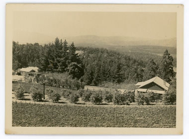
 Marysville & District Historical Society
Photograph (Item) - Colour photograph, Unknown
A colour photograph of Gould Memorial Drive which is on the Marysville-Buxton Road near Marysville in Victoria.A colour photograph of Gould Memorial Drive which is on Marysville-Buxton Road just outside Marysville in Victoria. The planting of the avenue of Lombardi Poplars was initiated by Mrs Joy Gould and the trees were planted by workers of the Gould Mill. The intention was for the avenue to extend from Marysville to Buxton. However, this was never fully realised. In Autumn the trees turn a brilliant yellow and are a major tourist attraction. john lloyd gould, joy gould, gould mill, gould memorial drive, marysville-buxton road, marysville, buxton, victoria, photograph, lombardi poplars