Showing 1494 items
matching the department of goldfields
-
 Bendigo Historical Society Inc.
Map - EGERTON : COUNTY OF BENDIGO, 29-5-23
Map. Egerton, County of Bendigo, Minto, Giggorra, Elmore, Nolan, Goornong, Bagshot, Whirrakee, Bendigo Creek, Round Creek. By authority A.J. Mullett, Government Printer, Melbourne.Photo-Lithographed at the Department of Lands and Survey, Melbourne by W.J. Butson, 29-5-23. Price 1/-. (number 48 in map cupboard 1)A.J. Mullett, Government Printer, Melbourne.map, bendigo, egerton -
Bendigo Historical Society Inc.
Map - EGERTON : COUNTY OF BENDIGO, 1-3-30
Map. Egerton, County of Bendigo, Minto, Diggorra, Elmore, Nolan, Goornong, Bagshot, Whirrakee. Bendigo Creek. By authority J.J. Green, Govt. Printer. Photo-Lithographed at the Department of Lands and Survey, Melbourne. Price 2/-. 1-3-30. (number 47 in map cupboard 1)J.J. Green, Govt. Printer.map, bendigo, egerton -
Bendigo Historical Society Inc.
Map - BAGSHOT : COUNTY OF BENDIGO, November 1948
Map. Bagshot. County of Bendigo, Huntly, Whirrakee, Egerton, Goornong, Ellesmere, Wellsford. Reedy Creek, Sandy Creek. Drawn and reproduced at the Department of Lands and Survey, Melbourne, Victoria. November 1948, Price 2/-. By authority J.J. Gourley, Government Printer, Melbourne. (number 46 in map cupboard 1)J.J. Gourley, Government Printer, Melbourne.map, bendigo, bagshot -
Bendigo Historical Society Inc.
Map - JANIEMBER EAST : COUNTY OF BENDIGO, 15-1-34
Map. Janiember East, County of Bendigo, Jarklan, Pompapiel, Yarrayne, Powlet, Janiember West, Serpentine Creek, Caney's Blind Creek Long Plain Creek, Loddon River. By authority : H.J. Green, Govt. Printer, Melbourne. Drawn and reproduced at the Department of Lands and Survey, Melbourne, Victoria. Price 2/-. 15-1-34. (number 45 in map cupboard 1)H.J. Green, Govt. Printer, Melbourne.map, bendigo, janiember east -
Bendigo Historical Society Inc.
Map - GOORNONG : COUNTY OF BENDIGO, September 1943
Map. Goornong, County of Bendigo, Egerton, Bagshot, Ellesmere, Muskerry, Campaspe, Nolan, Campaspe River, Town of Goornong. By authority : H.E. Daw, Government Printer, Melbourne. Drawn and reproduced at the Department of Lands and Survey, Melbourne, Victoria. September 1943, Price 2/-. (number 44 in map cupboard 1)H.E. Daw, Government Printer, Melbourne.map, bendigo, goornong -
Bendigo Historical Society Inc.
Map - GOORNONG : COUNTY OF BENDIGO, 27-10-25
Map. Goornong, County of Bendigo, Egerton, Nolan, Ellesmere, Bagshot. Town of Goornong, Northern Railway. Campaspe, Muskerry, Campaspe River. Photo-Lithographed at the Department of Lands and Survey, Melbourne by W.J. Butson, 27-10-25,Price 1/-. By authority: H.J. Green, Government Printer, Melbourne. (number 43 in map cupboard 1)H.J. Green,Govt.Printer, Melbourne.map, bendigo, goornong -
Bendigo Historical Society Inc.
Map - HUNTLY : COUNTY OF BENDIGO, August 1954
Map. Huntly, County of Bendigo. Whirrakee, Bagshot, Wellsford, Nerring, Neilborough, Township of Huntly. Drawn and reproduced at the Department of Lands and Survey, Melbourne, Victoria. August 1954. Price 2/-. By authority W.M. Houston, Government Printer. (number 42 in map cupboard 1)W.M. Houston, Govt. Printer.map, bendigo, huntly -
Bendigo Historical Society Inc.
Map - WOODSTOCK : COUNTY OF BENDIGO, 4-7-35
Map. Woodstock, County of Bendigo, Derby, Leichardt, Marong, Shelbourne, Laanecoorie, Tarnagulla. Bradford Creek, Maldon and Laanecoorie Railway. Drawn and reproduced at the Department of Lands and Survey, Melbourne, Victoria.4-7-35. Price 2/-. By authority H.J. Green,Govt. Printer. (number 41 in map cupboard 1)H.J. Green, Govt. Printer.map, bendigo, woodstock -
Bendigo Historical Society Inc.
Map - EPPALOCK : COUNTY OF BENDIGO, 1982
Map. Eppalock, County of Bendigo, Axedale, Knowsley, Heathcote, Tooborac, Kyneton, Lancefield, Pyalong, Seymour, Graytown, Toolleen, Colbinabbin, Costerfield, Redesdale, Mia Mia, Nagambie, Department of Interior, Puckapunyal Military Area, Various connecting roads. Shire of McIvor. Updated Dec.1982. (number 40 in map cupboard 1)map, bendigo, eppalock -
Bendigo Historical Society Inc.
Map - EPPALOCK : COUNTY OF BENDIGO, 2-11-14
Map. Eppalock, County of Bendigo,Lyell, Sedgwick, Strathfieldsaye, Axedale, Knowsley, Kimbolton. Photo-Lithographed at the Department of Lands and Survey, Melbourne by W.J. Butson, 2-11-14. Price 1/-. (number 39 in map cupboard 1)W.J. Butson.map, bendigo, eppalock -
 Bendigo Historical Society Inc.
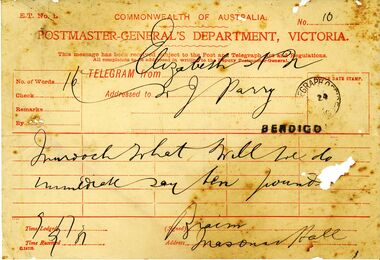
Document - JUNE PARRY COLLECTION: TELEGRAM FROM ELIZABETH ST NORTH TO J PARRY, 1924
1924 dated telegram from Elizabeth Street Postmasters Generals Department, Vic to G Parry. 16 words. Murdoch what will we do immediate say ten pounds. Signed Braim Masonic hall.communication, telegraphic, telegram, telegram transmission -
Bendigo Historical Society Inc.
Map - YALLOOK : COUNTY OF BENDIGO, 30-1-28
Map. Yallook, County of Bendigo, L4942, Talambe, Tandarra, Neilborough, Yarraberb, Salisbury, Pompapiel. Drawn and reproduced at the Department of Lands and Survey, Melbourne, Victoria. 30-1-28. H.J. Green, Govt. Printer, Melbourne. (number 18 in map cupboard 1)H.J. Green, Govt. Printer.map, bendigo, yallook -
Bendigo Historical Society Inc.
Map - TALAMBE : COUNTY OF BENDIGO, 17-12-15
Map. Talambe, County of Bendigo, Hayanmi, Dingee, Tandarra, Yallook, Pompapiel. Photographed at the Department of Lands and Survey, Melbourne by W.J. Butson,17-12-15, Price 1/-. Albert J. Mullett, Govt. Printer, Melbourne. (number 17 in map cupboard 1)Albert J. Mullett, Government Printer, Melbourne.map, bendigo, talambe -
Bendigo Historical Society Inc.
Map - YARRABERB : COUNTY OF BENDIGO, 23-2-15
Map. Yarraberb, County of Bendigo, Salisbury, Yallook, Neilborough, Nerring, Leichardt, Bridgewater. L5373. Photographed at the Department of Lands and Survey, Melbourne by W.J. Butson 23-2-15. Price 1/-.By authority: Albert J. Mullett, Government Printer, Melbourne. (number 16 in map cupboard 1)By authority Albert J. Mullett, Government Printer.map, bendigo, agricultural lands -
Bendigo Historical Society Inc.
Map - TARNAGULLA : COUNTY OF BENDIGO, 1959
Map. Tarnagulla, County of Bendigo, County of Gladstone, Inglewood, Glenalbyn, Kingower, Moliagul, Painswick, Waanyarra, Laanecoorie, Woodstock, Derby, Loddon River, Dunolly to Inglewood Railway, Laurie Railway Station, Township of Tarnagulla, Tarnagulla Rifle Range, Township of Llanelly, Arnold Railway Station, Bullabul Creek, Kangderaar Creek, Township of Newbridge. By authority A.C. Brooks, Government Printer, Melbourne. Drawn and reproduced at the Department of Lands and Survey, Melbourne, 1959. (number 117 in map cupboard 1)A.C. Brooks, Government Printer, Melbourne.map, bendigo, tarnagulla -
Bendigo Historical Society Inc.
Map - SALISBURY WEST : COUNTY OF BENDIGO, 24-6-24
Map. Salisbury, County of Bendigo, County of Gladstone, Powlett, Yarrayne, Bridgewater, Inglewood, Glenalbyn, Kurting, River Loddon, Bulabul Creek. By authority A.J. Mullett, Government Printer, Melbourne. Photo-Lithographed at the Department of Lands and Survey, Melbourne by W.J. Butson, 24-6-24. Price 1/-. (number 116 in map cupboard 1)A.J. Mullett, Government Printer, Melbourne.map, bendigo, salisbury west -
Bendigo Historical Society Inc.
Map - DARGILE : COUNTY OF BENDIGO, November 1953
Map. Dargile, County of Bendigo, County of Rodney, Cornella Creek, Northern Highway, Crosbie, Redcastle, Knowsley East, Heathcote, Costerfield, Moormbool West. By authority W.M. Houston, Government Printer. Drawn and reproduced at the Department of Lands and Survey, Melbourne. November 1953. Price 2/-. (number 115 in map cupboard 1)W.M Houston, Government Printermap, bendigo, dargile -
Bendigo Historical Society Inc.
Map - CROSBIE : COUNTY OF BENDIGO, 1970
Map. Crosbie, County of Bendigo, County of Rodney, Toolleen, Weston, Dargile, Knowsley East, Redcastle, Township of Toolleen, Northern Highway, Mt.Pleasant Creek. By Authority R.H. Rixon, Government Printer, Melbourne. Drawn and reproduced at the Department of Lands and Survey, Melbourne. 1970. Price $1.00. (number 114 in map cupboard 1)R.H. Rixon, Government Printer, Melbourne.map, bendigo, crosbie -
Bendigo Historical Society Inc.
Map - CROSBIE : COUNTY OF BENDIGO, 28-9-76
Map. Crosbie, County of Bendigo, County of Rodney, Mt. Pleasant Creek, Weston, Toolleen, Redcastle, Dargile, Knowsley East. W.E. Porter, draughtsman, August 1878. Photo-Lithographed at the Department of Lands and Survey, Melbourne, J. Noune,28-9-76. (number 113 in map cupboard 1)W.E. Porter, Draughtsmanmap, bendigo, crosbie -
Bendigo Historical Society Inc.
Map - CAMPASPE : COUNTY OF BENDIGO, 1964
Map. Campaspe, County of Bendigo, County of Rodney, Runnymede, Nolan, Muskerry, Toolleen, Colbinabbin, Campaspe River, Goornong, Mount Pleasant Creek. By authority A.C. Brooks, Government Printer, Melbourne. Drawn and reproduced at the Department of Lands and Survey, Melbourne. 1964. Price 10/- per sheet. (number 112 in map cupboard 1)A.C. Brooks, Government Printer, Melbourne.map, bendigo, campaspe -
Bendigo Historical Society Inc.
Map - YALLOOK : COUNTY OF BENDIGO, 1957
Map. Yallook, County of Bendigo, Talambe, Neilborough, Yarraberb, Salisbury, Pompapiel. Drawn and reproduced at the Department of Lands and Survey, Melbourne,1957. Distances shown on the plan are derived from original surveys of varying dates and whilst approximately correct do not necessarily conform to modern standards of accuracy. For survey information application should be made to the central plan office, or to the office of titles. Some ink scibbles appear at the right top of this map. Price 2/-. (number 14 in map cupboard 1)By Authority W.M.Houston, Govt.Printer,Melbourne.map, bendigo, yallook -
Bendigo Historical Society Inc.
Map - BENDIGO AND DISTRICT PARISH MAPS, 21-10-26
Map. Sandhurst, County of Bendigo, City of Bendigo, Strathfieldsaye, Mandurang, Marong, Nerring, Borough of Eaglehawk, Township of Kangaroo Flat, Lockwood, Huntly, Epsom, Wellsford. By Authority H.J. Green, Government Printer, Photo-Lithographed at the Department of Lands and Survey, Melbourne bj W.J Butson 21-10-26,Price 1/-. (number 13 in map cupboard 1)By Authority H.J. Green, Govt. Printermap, bendigo, sandhurst -
Bendigo Historical Society Inc.
Map - HAWKESTONE : COUNTY OF BENDIGO, 7-11-15
Map. Hawkestone, County of Bendigo, County of Talbot, Lyell, Sutton Grange, Redcastle, Elphinstone, Metcalfe, Coliban River, Myrtle Creek. Albert J. Mullett, Government Printer, Melbourne. Photo-Lithographed at the Department of Lands and Survey, Melbourne by W.J. Butson,7-11-15. Price 1/-. (number 111 in map cupboard 1)Albert J. Mullett, Government Printer, Melbourne.map, bendigo, hawkestone. -
Bendigo Historical Society Inc.
Map - MUSKERRY : COUNTY OF BENDIGO, 1962
Map. Muskerry, County of Bendigo, County of Rodney, Goornong, Ellesmere, Axedale, Weston, Crosbie, Toolleen, Campaspe, Forest or Mannering Creek, Back Creek, Campaspe River. By authority A.C. Brooks, Government Printer, Melbourne. Drawn and reproduced at the Department of Lands and Survey, Melbourne, 1962. Price 2/-. (number 110 in map cupboard 1)A.C. Brooks, Government Printer, Melbourne.map, bendigo, muskerry -
Bendigo Historical Society Inc.
Map - REDCASTLE : COUNTY OF BENDIGO, 10-8-08
Map. Redcastle, County of Bendigo, County of Rodney, Cornella, Cherrington, Dargile, Crosbie, Cornella Creek, Redcastle Creek, Mount Camel, Township of Redcastle. Photo-Lithographed at the Department. of Lands and Survey, Melbourne by T.F. McGaraun 10-8-08. (number 109 in map cupboard 1)T.F. McGaraunmap, bendigo, redcastle -
Bendigo Historical Society Inc.
Map - WESTON : COUNTY OF BENDIGO : COUNTY OF RODNEY, 4-5-21
Map. Weston, County of Bendigo, County of Rodney, Muskerry, Crosbie, Knowsley East, Knowsley, Axedale. Back Creek. By authority A.J. Mullett, Government Printer, Melbourne. Photo-Lithographed at the Department of Lands and Survey, Melbourne by W.J. Butson 4-5-21. Price 1/-. (number 108 in map cupboard 1)A.J. Mullett, Government Printer, Melbourne.map, bendigo, weston -
Bendigo Historical Society Inc.
Map - RUNNYMEDE : COUNTY OF BENDIGO, 8-12-13
Map. County of Bendigo, County of Rodney, Burnewang, Elmore, Nolan, Campaspe, Colbinabbin, Burramboot, Corop, Township of Runnymede, Campaspe River, Mount Pleasant Creek. Photo-Lithographed at the Department of Lands and Survey, Melbourne by W.J. Butson.8-12-13. Price 1/-. (number 107 in map cupboard 1)W.J. Butsonmap, bendigo, runnymede -
Bendigo Historical Society Inc.
Map - TOOLLEEN : COUNTY OF BENDIGO, 25-5-26
Map. Toolleen, County of Bendigo, County of Rodney, Campaspe, Colbinabbin, Cornella, Crosbie, Muskerry, Mount Pleasant Creek, Township of Toolleen. By authority H.J. Green, Govt. Printer. Photo-Lithographed at the Department of Lands and Survey, Melbourne by W.J. Butson, 25-5-26. (number 106 in map cupboard 1)H.J. Green, Govt. Printermap, bendigo, toolleen -
Bendigo Historical Society Inc.
Map - TOOLLEEN : COUNTY OF BENDIGO, 25-5-26
Map. Toolleen, County of Bendigo, County of Rodney, Campaspe, Colbinabbin, Cornella, Crosbie, Muskerry, Mount Pleasant Creek, Township of Toolleen. By authority H.J. Green, Govt. Printer. Photo-Lithographed at the Department of Lands and Survey, Melbourne by W.J. Butson, 25-5-26. (number 105 in map cupboard 1)H.J. Green, Govt. Printer.map, bendigo, toolleen -
Bendigo Historical Society Inc.
Map - KNOWSLEY EAST : COUNTY OF BENDIGO, 18-112-77
Map. Knowsley East, County of Bendigo, County of Rodney, Weston, Knowsley, Crosbie, Dargile, Heathcote, Forest Creek, Shingle Hut Creek, Mt. Camel Estate, Sheep Station Creek, Mount Ida Creek. Photo-graphed at the Department of Lands and Survey, Melbourne by J. Noune 18-12-77, (number 104 in map cupboard 1)J. Nounemap, bendigo, knowsley east