Showing 2559 items
matching aerial
-
 Lakes Entrance Historical Society
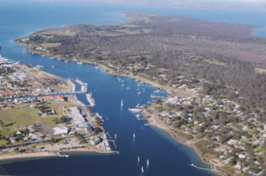
Photograph - McMillan Strait, 2005 c
Colour aerial photograph of McMillan Strait between Paynesville on left and Raymond Island on right on Gippsland Lakes Victoriaaerial photograph, township -
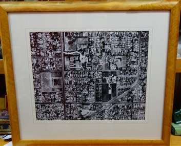
 Creswick Campus Historical Collection - University of Melbourne
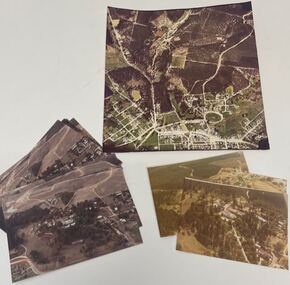
Photograph - Aerial views of the Victorian School of Forestry Grounds and buildings, Victorian School of Forestry
Three sets of Aerial views of the Victorian School of Forestry Grounds and buildings taken around the 1960s to early 1970s -
 Phillip Island and District Historical Society Inc.
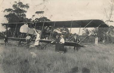
Photograph, 1920
Rhylston Park, an Italianate villa, was built in 1886 and the home of Mr Vaughan. One of a collection of over 400 photographs in an album commenced in 1960 and presented to the Phillip Island & Westernport Historical Society by the Shire of Phillip IslandPhotograph of an aeroplane and the first aerial bread delivery in Australia at Rhylston Park, Cowes, Phillip Island about 1920local history, photography, aeroplane, bread delivery, black & white photograph, air transport, john jenner, bryant west -
 Federation University Historical Collection
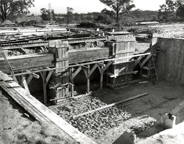
Photograph, N.l. Harvey & Son, Mount Helen Campus, 1968, 1969
The Federation University campus at Mount Helen was first used by students in 1970.Seven photographs of the Mt Helen Campus Stage one development. .1) Aerial view of foundation work, from west, towards Green Hill .2) Aerial View from South. Earthworks and foundations .3) Aerial View from south west. Earthworks, general view .4) Aerial View from above the South West corner of E building. .5) Aerial View from North East. Gear Avenue in background .6) Aerial View from North West. Earthworks extend from Gear Avenue .7) Ground level view. First columns of E building. .13) Mt Helen development Stage One, Engineering Diploma Buildings. This image shows the wall beam and pier construction to the East Wall of the Fluid Mechanics Laboratory adjacent to the pump chamber, 17 June 1968. .18) Flume Pit and Pump Chamber, 15 July 1968. .28) East Wing Pit Looking North, 26 August 1968 .40) Construction as of 04 November 1968federation university, federation university australia, feduni, university of ballarat, ballarat college of advanced education, ballarat institute of advanced education, building, earthworks, foundation, early development, soil testing laboratory -
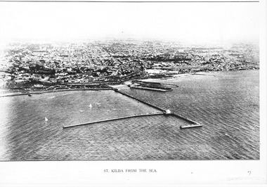 St Kilda Historical Society
Photograph - Photograph Arial
aerial photographPhotograph black and white arial Copy of original. View of water, yachts in foreground and pier with Catani gardenes midground and rest of St kilda in distance.St Kilda from the Sea -
 Moorabbin Air Museum
Book - Aerial navigation, Flightdeck The Story of Air Navigation
Overview of technical aspects of airliner operation for laymen, circa 1960sOverview of technical aspects of airliner operation for laymen, circa 1960snavigational aids, airliners, meteorology, flight planning -
Moorabbin Air Museum
Book - Aerial navigation, Flight - Meteorology, Aircraft Instruments and Navigation
Overview of basic meteorology , aircraft instrumentation & navigation, circa 1943non-fictionOverview of basic meteorology , aircraft instrumentation & navigation, circa 1943atmosphere, weather map, airway weather service, aerial photogrophy, aviation radio, aircraft instruments, aerial navigation -
Moorabbin Air Museum
Book - Aerial navigation, The Complete Air Navigator
Overview of the methods of aerial navigation, circa 1954non-fictionOverview of the methods of aerial navigation, circa 1954background, observational methods, general application -
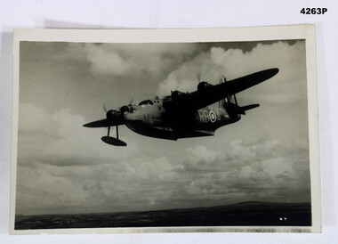 Bendigo Military Museum
Photograph - SUNDERLAND PHOTO, Post 1943
Item in the collection of Reginald Charles Allardice No 418557 RAAF. Refer Cat No 3627.5 for his service details.Aerial B & W photo of a Sunderland Flying Boat over land. On the rear a paper is pasted to with typed writing in purple.On rear, “ BRITISH OFFICIAL PHOTOGRAPH, No CH 3210 Air Ministry photograph - crown copyright reserved. On patrol, a short Sunderland Flying Boat of the RAF Coastal Command sets out on a patrol. This particular aircraft is flown by the RAAF Squadron operating with Coastal Command The Sqd is on the 9,000 hours flying mark during its 16 months operating duty in this country”photography, sunderlands, military -
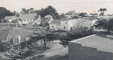 Phillip Island and District Historical Society Inc.
Photograph, c. 1959
One of a collection of over 400 photographs in an album commenced in 1960 and presented to the Phillip Island & Westernport Historical Society by the Shire of Phillip IslandAerial photograph of the intersection of Thompson Avenue & Chapel Street showing General Store, Phillip Island Garage and Catholic Church.local history, photography, intersection thompson avenue & chapel street, cowes, black & white photograph, thompson avenue cowes, chapel street cowes, garages, churches, john jenner, bryant west -
Glenelg Shire Council Cultural Collection
Photograph - Photograph - berthing of "Aquagem', Portland Harbour, 21/03/1972
UnknownBlack and white photograph. Aerial view of berthing of veseel 'Aquagem', using tug 'Tarragal' and others at K.S.Anderson wharf. Unframed.Front: (no inscriptions) Back: (no inscriptions)tug, tarragal, aquagen, k s anderson -
Glenelg Shire Council Cultural Collection
Photograph - Photograph - Aerial Photograph of Portland, n.d
Port of Portland Authority archives.Front: (no inscriptions) Back: (no inscriptions)port of portland archives -
Glenelg Shire Council Cultural Collection
Photograph - Photograph - aerial photo of Portland, n.d
Port of Portland AuthorityBack: fdou3 - pencilport of portland archives, aerial photography, bentinck street, portland railway station, ocean pier -
Glenelg Shire Council Cultural Collection
Photograph - Photograph - Main Breakwater construction, Portland, n.d
Port of Portland Authority ArchivesFront: 14/1/58- pencil Back: 14/1/58 - Pencilport of portland archives, main breakwater construction, harbour development, aerial photography -
Glenelg Shire Council Cultural Collection
Photograph - Photograph - Main Breakwater Construction, n.d
Port Of Portland Authority Archivesport of portland archives, portland harbour, fawthrop lagoon, aerial photo, main breakwater construction -
Glenelg Shire Council Cultural Collection
Photograph - Photograph - Main Breakwater Construction, n.d
Port of Portland Authority Archivesport of portland archives, reclamation land, breakwater construction, battery point -
Port Melbourne Historical & Preservation Society
Photograph - Aerial view of River Yarra and Victoria Dock, 1920s
Copy of aerial photo of River Yarra and Victoria Dock, 1920s; pasted onto A4 sheet with computer graphics bordertransport - shipping -
Tatura Irrigation & Wartime Camps Museum
Aerial Photograph, 1959
Enlarged aerial photo of Tatura township taken by J. Underwood (Kyabram) in January 1959. Photo framed with glass front.Tatura Jan 1959. Arthur J. Underwood Photographer Tel. Kyabram 629tatura, aerial photography, photography, photograph, slides, film -
Tatura Irrigation & Wartime Camps Museum
Book, Hill Top Golf & Country Club, 1985
History of formation of Hill Top Golf and Country Club and Bowls ClubSoft cover - pale green with black and white aerial photograph of Hill Top across middle and Hill Top logo.Presented to Tatura and District by J Forster. 26.6.85hill top golf and country club, hill top bowls club -
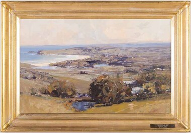 Wangaratta Art Gallery
Painting, Ken Knight, Coastal Vista, c. 1992
Knight’s art style is heavily influenced by the Australian Impressionist movement of the late 19th century and he paints his work in outdoor settings, which is known as plein-air painting. Rural City of Wangaratta Collection, Wangaratta Art Prize Grand Winner 1992.An aerial landscape of a costal view painted in oil using a tonal colour palette of browns, blues, greens, oranges, and whites.Obverse: KEN KNIGHT/ (bottom right corner) WANGARATTA ART SHOW/ GRAND WINNER 1992/ 'COASTAL VISTA'/ By KEN KNIGHT/ (plaque mounted on frame)wangaratta art gallery, ken knight, landscape, painting, costal, plein-air, plein air -
Whitehorse Historical Society Inc.
Map, Mitcham Road, c1970
Enlarged aerial photo of the intersection of Mitcham and East Doncaster Roads, Mitcham. Scale 1 inch : 40 feet.Enlarged aerial photo, c1970, of the intersection of Mitcham and East Doncaster Roads, Mitcham. Scale 1 inch : 40 feet.Enlarged aerial photo of the intersection of Mitcham and East Doncaster Roads, Mitcham. Scale 1 inch : 40 feet.mitcham road, mitcham, quarry road, mitcham, doncaster east road, mitcham, wooddale grove, mitcham, mitcham primary school, no. 2904, aerial photographs -
Whitehorse Historical Society Inc.
Map, Springvale Road, 1987
Aerial photograph of cnr Springvale Road and Burwood Highway, south past Highbury Road and west past Blackburn Road.Aerial photograph of cnr Springvale Road and Burwood Highway, south past Highbury Road and west past Blackburn Road.Aerial photograph of cnr Springvale Road and Burwood Highway, south past Highbury Road and west past Blackburn Road.aerial photographs, blackburn road, burwood east, highbury road, burwood east, burwood highway, burwood east, springvale road, burwood east, burwood east -
 Kew Historical Society Inc
Photograph - Aerial View of East Kew, c.1930
The Municipality of Kew was proclaimed in 1860. This eastern section of Kew was settled from the 1850s with all land sold in the vicinity by 1851. The original large estates were further subdivided in the second half of the 19th and in the first decades of the 20th centuries.Early aerial photograph of KewFramed aerial photograph of that part of Kew in which is located Genazzano FCJ, the Kew Reservoir, and the retail nurseries of Bennett’s and Rimington's.genazzano fcj, kew reservoir, rimington's nurseries, bennett's nursery, cotham road, mont victor road (kew) -
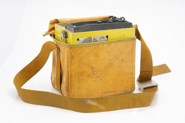 Department of Energy, Environment and Climate Action
Weston portable 7 channel radio (AKA Yellow Peril)
After the 1939 bushfires, the Forests Commission Victoria invested heavily in a radically new communications network. After suffering some inevitable delays due to the war, radio VL3AA switched into full operation in October 1945 proudly beaming out 200 watts across the State. But by today’s standards, the technology was primitive and the reception poor unless the user was on a high point somewhere. The radio signal was "line-of-sight" and bounced between fire towers and relay transmitters across the mountains back to the District offices. The advent of solid-state electronics in the 1960s replaced the more delicate valve sets which enabled greater use of vehicle mounted radios. The Commission continued to research, develop and build new radios at its many workshops around Victoria. The network was supported by a large team of skilled radio technicians. The more secure and versatile State Mobile Radio (SMR) digital trunk system came into operation in about 1995. Upgraded Tait Radios were purchased in 2014 after recommendations of the 2009 Bushfires Royal Commission. But it was the convergence of separate technologies such as 5G mobile phones, high-capacity and light-weight lithium batteries, Wi-Fi, the ever-expanding internet, cloud data storage, digital cameras, GPS, personal organisers and hundreds of supporting Apps into powerful smartphones and tablets which revolutionised bushfire communications from the mid-2000s. Portable radio with handset Includes battery pack in vinyl carry case and carry strap With socket to attach external aerialModel Ebushfire, radios, forests commission victoria (fcv) -
University of Melbourne, Burnley Campus Archives
Map, Photo Mapping Services Pty. Ltd, Burnley College Burnley Gardens, 1995
HistoricalMap compiled by Photo Mapping Services Pty. Ltd., using aerial photography, dated 9th July, 1995. (1) Coloured proof. Scale 1:500. Aerial views, with and without trees marked, of Burnley Gardens: (2) Map with trees (3) Map without trees, sections numbered but no legend.burnley college, gardens, trees -
Moorabbin Air Museum
Drawing (item) - Unmanned Aerial Vehicles, Kerkanya Vehicle
Unmanned Aerial Vehicles -
Moorabbin Air Museum
Book (item) - Unmanned Air Vehicles, Unmanned Air Vehicles An Illustrated Study of UAVs
Unmanned Aerial Vehicles -
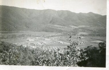 Kiewa Valley Historical Society
Photograph - Mount Beauty from Bogong Hill, 1950
The new State Electricity Commission construction camp at the head of the Kiewa Valley was for workmen on the second power station in the project expected to be the most modern and best equipped in Australia… In contrast to the early Kiewa days of horses and canvas tents, the new camp, with its modern amenities, compared favourably with any country town. Administration of the Kiewa Scheme was moved from Tawonga to Mount Beauty in 1946. The first house in Mount Beauty, in Hollonds Street, was occupied by the co-op store manager from November 1946. The new Mess Hall at Mt Beauty was opened with much ceremony in early November 1946. The houses up to Nelse street were erected from 1946 onward and then the township was extended beyond Nelse Street in 1950. The workmen's camp was enlarged in 1950 to the extent of providing accommodation for a total of 1,200.Shows early construction of the town of Mt. Beauty surrounded by farmland taken in 1950 during the early stages of construction of the Kiewa Hydro electric SystemBlack and white photograph - aerial view of Mt Beauty taken from Bogong Hill. Photograph framed by 6mm white boarder.Handwritten on back of photograph in black ink - Mt Beauty from Bogong Hill 1950 Printed on rear Volox 2428mt beauty, bogong hill, secv -
Phillip Island and District Historical Society Inc.
Photograph
Phillip Island suspension Bridge built 1938/1940 - demolished 1970. Part of an album compiled and donated by Mrs Helen Jansson.Print of Phillip Island Suspension Bridge. Aerial view showing Jetties at left with sweep of sandy beaches middle to top left.No. 1. Phillip Island Bridge, Victoria. Airapy Photolocal history, photography, photographs, slides, film, civil engineering, bridges, jetties, phillip island suspension bridge, black & white photograph, mrs. helen jansson, suspension bridges, phillip island -
 Phillip Island and District Historical Society Inc.
Photograph, 1960
One of a collection of over 400 photographs in an album commenced in 1960 and presented to the Phillip Island & Westernport Historical Society by the Shire of Phillip IslandAerial photograph of the Cowes Kindergarten in Chapel Street, Cowes. Now next to the Cowes State School in Settlement Road. (JG 2017)local history, photography, cowes kindergarten, black & white photograph, kindergartens, chapel street cowes, john jenner, bryant west