Showing 17450 items
matching bay-bridge
-
 Greensborough Historical Society
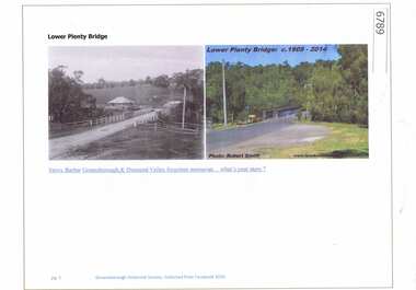
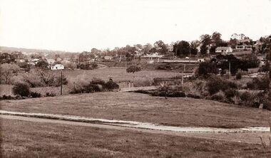
Article and Photograph, Lower Plenty Bridge, 2016_
2 Photographs of the area around the Lower Plenty Bridge, 1906 and 2014.This photograph and text was copied from a Facebook site. Members are people who lived in the Greensborough area and share their reminiscences of the area with others. The site is administered by a GHS member but is not officially affiliated with the Society. Any information is the opinion of the contributor. Article and photograph sourced from social media.lower plenty -
 Greensborough Historical Society
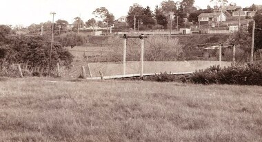
Photograph - Digital image, Jan Lewis, Flintoff Street swing bridge with Greensborough Railway Station in background circa 1958, 1958c
Flintoff Street swing bridge and Greensborough station in background circa 1958Digital copy of black and white photographgreensborough station, flintoff street -
 Greensborough Historical Society
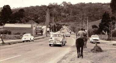
Photograph - Digital image, Jan Lewis, Horse Riding down Main Street Greensborough Station looking toward bridge circa 1958, 1958c
Main Street Greensborough Station looking toward bridge circa 1958.Digital copy of black and white photographmain street greensborough -
 Greensborough Historical Society
Photograph - Digital image, Marilyn Smith, Railway Road Rail Bridge over Plenty River Briar Hill, 17/09/2014
Rail bridge over Railway Road Greensborough, near Para Road.Digital copy of colour photographrailway road greensborough, para road greensborough -
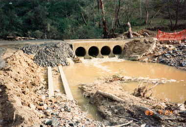 Eltham District Historical Society Inc
Photograph, Bridge construction over the Diamond Creek, Charlber Lane, St Andrews, 24 July 1989, 24 Jul 1989
The first BEBO Arch pre-cast concrete bridge construction in VictoriaNine colour photographic printsbebo arch, bridge construction, charlber lane, diamond creek, st andrews -
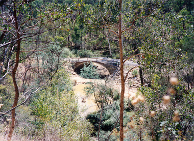 Eltham District Historical Society Inc
Photograph, Charlber Lane Bridge, St Andrews
A BEBO Arch pre-cast concrete construction bridge, the first in VictoriaA BEBO Arch pre-cast concrete construction bridge, the first in VictoriaThree colour photographic printsbebo arch, bridge construction, charlber lane, diamond creek, st andrews -
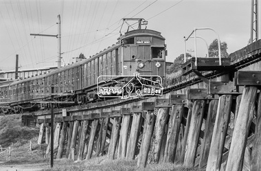 Eltham District Historical Society Inc
Photograph, George Coop, Tait Electric Train (Red Rattler) crossing the Railway Trestle Bridge at Eltham, c.1981, 1981
Heading to Princes Bridge in Melbourne Eltham Shire Council Offices in backgroundDigital TIFF file Scan of 35mm Ilford FP4 black and white transparencyeltham shire office, eltham trestle bridge, red rattler, tait train -
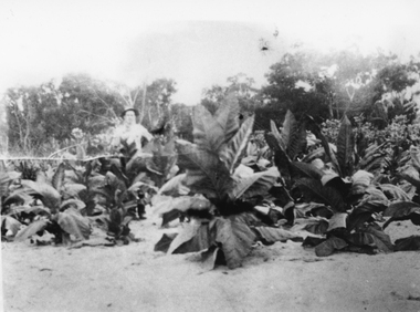 Stawell Historical Society Inc
Photograph, Mr Charles Pickering with his Tobacco Crop at Dadswells Bridge c1930
Tobacco Crop Grown by Charles Pickering at Dadswells Bridge c 1930.Black and white photograph of a scene depicting Tobacco plants. A person is standing behind the crop.stawell -
 Stawell Historical Society Inc
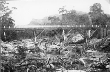
Photograph, Delley's Bridge in Hall’s Gap showing Fyans Creek riverbed 1917
Delley's Bridge Hall’s Gap 1917 showing Fyans Creek riverbedstawell -
 Stawell Historical Society Inc
Photograph, Railway Line from the Oddfellows Bridge c1930's
Sepia Photograph of rail line from Oddfellows Bridge 1930'sstawell railways transport -
 Robin Boyd Foundation
Slide, Robin Boyd, 1950
Penleigh Boyd, Robin and Patricia Boyd's son, writes “Prior to 1950 Robin, like most other amateur or hobby photographers, took black and white printed photographs. The oldest slides date from 1950 when Robin and Patricia travelled to Europe on Robin’s Robert Haddon Travelling Scholarship.” In 1948 Robin Boyd was awarded ‘joint first place’ in the Robert Haddon competition for his design of Mildura art gallery. The scholarship helped fund their first overseas trip. Robin and Patricia were passengers on the Greek ship “Cyrenia” departing in May 1950, passing through the Suez Canal and landing in Genoa five weeks later. For six months, they travelled extensively throughout Europe (predominantly driving themselves) - France, Italy, United Kingdom, Sweden, Denmark, Germany, Austria, Switzerland and Spain.Colour slide in a mount. Bridge. ScotlandScoland / Bridge (All Handwritten)haddon travelling scholarship, haddon, robin boyd, slide -
 Nillumbik Shire Council
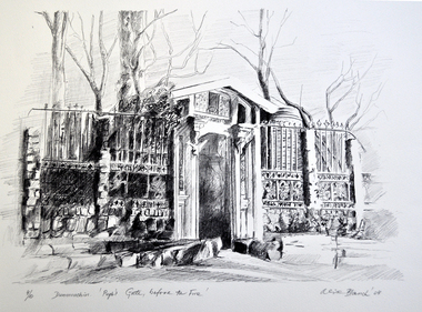
Print (Lithograph) Alice Blanch CHEHOVSKI, Alice B. (Blanch) Chehovski, Dunmoochin. Pugh's Gate, before the Fire, / Printed 2004
Alice Blanch Chehovski was born in Queensland to a Russian mother and Polish father. When her father died leaving three small children to bring up on her own, her took them back to Russia to visit her own parents. In the following fateful year, Stalin came into power and the family was trapped by Russia closing its borders. At the age of twenty three, 1944, Alice entered Moscow's Institute of Decorative Arts and Applied Arts to study ceramics. Neither the subject of ceramics nor the academic drawing in fine pencil inspired her. At that time Moscow was surrounded by German troops, Russian culture was inhibited by the war and generally speaking it was not the time for arts. Alice said 'My soul and my hands were needed as a volunteer, to help the wounded soldiers survive'. Alice struggled through a lifetime of hardship and triumph before returning to her native land of Australia in 1981 at the age of 60.This lithographic print is one of a set of ten produced at Dunmoochin at the time of Clifton Pugh.Black and white lithograph on paper depicting the elaborate stone and wrought iron (open) gate/ entrance to Pugh's artist colony 'Dunmoochin' situated at Cottles Bridge. Bottom left of print: ed. no. '4/10' and work title. Bottom right of print: artist signature 'Alice Blanch '04'chehovski, dunmoochin, pugh, gate, fire, lithograph -
![Photograph - Digital image, Rand Street Bridge [Greensborough], 02/05/2013](/media/collectors/4f729f5697f83e03086015b8/items/572af0f12162f118342f250e/item-media/572af1252162f118342f2a1f/item-fit-380x285.jpg) Greensborough Historical Society
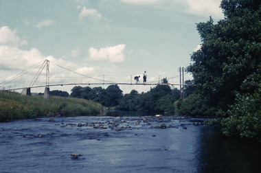
Greensborough Historical SocietyPhotograph - Digital image, Rand Street Bridge [Greensborough], 02/05/2013
These photographs of the Rand Street Bridge were taken in 2013 to show changes over 40 years, based on Ron Reynold’s sketches in the 1973 publication “Greensborough and Greenhills” published by Cypress Books. This is a pedestrian swing bridge over the Plenty River between Rand Street and Greensborough Station.Digital copy of colour photograph.greensborough and greenhills, rand street bridge, rand street greensborough, ron reynolds -
 The Beechworth Burke Museum Research Collection
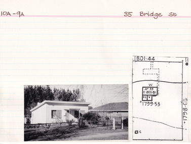
Card (Series) - Index Card, George Tibbits, 35 Bridge Street, Beechworth, 1976
George Tibbits, University of Melbourne. Faculty of Architecture, Building and Town & Regional PlanningIndex system that support the research for Beechworth : historical reconstruction / [by] George Tibbits ... [et al]Arranged by street names of BeechworthEach index card includes: street name and number of property, image of property, allotment and section number, property owners and dates of ownership, description of the property according to rate records, property floor plan with dimensions.beechworth, george tibbitsbeechworth, george tibbits -
 Warrnambool and District Historical Society Inc.
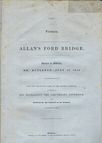
Document, Allan’s Ford Bridge 1852, 1852
This is an original Victorian Government document containing the printed version of 37 reports and letters regarding the building of the first Allansford bridge completed early in 1852. The correspondence dates from October 1850 to February 1852 and includes letters and reports from Melbourne Government employees such as Robert Hoddle, Chief Surveyor, David Lennox, Superintendent of Bridges and Lieutenant – Governor Charles La Trobe. The correspondence from local settlers included the names of William and John Allan, John Davidson and James Coulstock. The correspondence shows that some settlers in the Warrnambool/Port Fairy district wanted a portion of the Government allocated funds spent on the local roads and bridges in other locations. The 1852 Allansford bridge cost £480 and was replaced in 1870. This document has strong historical significance as it relates to one of the earliest State government works in the district and records the public imput into the decision.. It contains opinions and correspondence between a number of early settlers in the district at the time.Grey/blue paper document with black text. 21 pages plus 4 page index at back.allan's ford 1852, allansford bridge, allansford, history of allansford, warrnambool -
 Eltham District Historical Society Inc
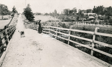
Photograph, Bridge over the Diamond Creek, Greensborough Road, Eltham, c.1885
Original (1874) bridge in Bridge Street, Eltham looking east over the Diamond Creek towards Maria Street (Main Road) at Little Eltham. In the distance to the right on Maria Street is the Methodist Church (1881), now Uniting Church, and the adjacent Commercial Bank of Australia branch building (1878). Part of a slide show presentation "Bridges & Waterways of the Shire" by Russell Yeoman to the 13 September 1989 Society meeting. The presentation included slides of historic photos from the Shire of Eltham Pioneers collections as well as several recent views.Photo of original 1875 timber and gravel surface bridge over the Diamon Creek in Bridge Street with views of orchards representative of the farming lands as well as the development along the northern end of Maria Street.Black and white photograph copybridge street, bridge street bridge, cba bank, diamond creek (creek), eltham, little eltham, main road, maria street, methodist church, uniting church -
 Eltham District Historical Society Inc
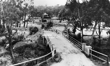
Negative - Photograph, View across bridge at Hurstbridge, Vic, c.1922
View across the new Monash bridge across the Diamond Creek at Hurstbridge looking towards the township, note steam train in centre background of image. Dated between the opening of bridge Nov. 1917 and provision of electric rail service Aug. 1926 - c.1922. Part of a slide show presentation "Bridges & Waterways of the Shire" by Russell Yeoman to the 13 September 1989 Society meeting. The presentation included slides of historic photos from the Shire of Eltham Pioneers collections as well as several recent views.This photo forms part of a collection of photographs gathered by the Shire of Eltham for their centenary project book ,"Pioneers and Painters: 100 years of the Shire of Eltham" by Alan Marshall (1971). The collection of over 500 images is held in partnership between Eltham District Historical Society and Yarra Plenty Regional Library (Eltham Library) and is now formally known as 'The Shire of Eltham Pioneers Photograph Collection.' It is significant in being the first community sourced collection representing the places and people of the Shire's first one hundred years.Digital image 4 x 5 inch B&W Negshire of eltham pioneers photograph collection, hurstbridge, bridge, steam train, diamond creek (creek), railway line, monash bridge -
 Eltham District Historical Society Inc
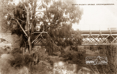
Photograph postcard, River Plenty Bridge, Greensborough
Postcard with view of bluestone bridge over the Plenty River on what is now Main Street, Greensborough. Built in 1860 by a Scottish stonemason, James Neave McKenzie. Most of the bridge was demolished in 1966 with the remaining bluestone arch preserved till 1983 when it was also demolished. This view about 1900.Digital file only Postcards scanned from the collection of Michael Aitken on loan to EDHS, 13 Feb 2018michael aitken collection, postcards, greensborough, plenty river bridge, plenty river -
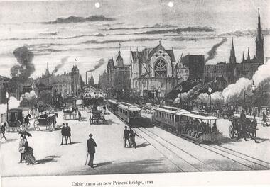 Melbourne Tram Museum
Photograph, "Cable trams on new Princes Bridge, 1888", 1885
Illustration on an A4 sheet of cable trams and other vehicles travelling over Princes Bridge, 1888. Has St Paul's Cathedral under construction and extensive smoke from steam locomotives travelling under the bridge. Looks north along Swanston St. Photo print also held.Demonstrates an artists view of a busy scene of Princes Bridge.Photocopy and black and white print. Two copies held.trams, tramways, princes bridge, swanston st, cable trams -
 Eltham District Historical Society Inc
Negative - Photograph, Bridge on Main Road, Eltham, c.1890
Possibly produced as a postcard. Caption in lower right hand corner reads: Bridge (at) Main Road Eltham. The long wooden suspension bridge over the Diamond Creek on Main Road at Eltham collapsed during flooding of the Diamond Creek on October 13 and 14, 1923. The original bridge was built around 1840 for the coach road when Cobb & Co.'s coach was the only conveyance between Eltham and Melbourne. Widespread damage was done in Melbourne and surrounding areas by floods resulting from the overflow of the Yarra at many points along its banks. A temporary bridge rigged up was severely damaged by the flooding of the creek and was closed to vehicular traffic in April 1924. A new concrete bridge was constructed to replace it and by May 1926 all the concrete piles and abutments had been completed. The bridge was finally completed and opened for traffic in September 1926, almost three years after it initially collapsed. Viewed from Antoinette Boulevard looking northwest towards Falkiner Street. The building in the distance believed to be Souters Cottage. On the far right on the very edge of the road verge are two Eucalypt trees, one of which is believed to be the large dead trunk still standing in present day.This photo forms part of a collection of photographs gathered by the Shire of Eltham for their centenary project book,"Pioneers and Painters: 100 years of the Shire of Eltham" by Alan Marshall (1971). The collection of over 500 images is held in partnership between Eltham District Historical Society and Yarra Plenty Regional Library (Eltham Library) and is now formally known as the 'The Shire of Eltham Pioneers Photograph Collection.' It is significant in being the first community sourced collection representing the places and people of the Shire's first one hundred years.Digital image 4 x 5 inch B&W Neg Black and white print 35mm positive transparencyshire of eltham pioneers photograph collection, eltham, main road bridge, eltham south, bridge, diamond creek (creek), significant tree, souters cottage, eltham lower park, main road, sepp -
Ringwood and District Historical Society
Notes for book, Rogaughan, John, Material for History of Kilsyth, Croydon, Burnt Bridge and Ringwood (book never completed). By John Rogaughan (undated), not known
Collected for a history book of Kilsyth, Croydon, Burnt Bridge and Ringwood but never completed.27 pages of notes intended for a local history book typed with some connections. +Additional Keywords: Rogaughan, John -
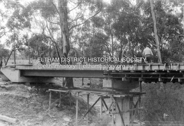 Eltham District Historical Society Inc
Album - Photograph, J.A. McDonald, Henley Road Bridge over Watsons Creek, Aug. 1962
Henley Road Bridge over Watsons Creek Eltham Abutment August 1962Record of various Shire of Eltham infrastructure works undertaken during the period of 1952-1962 involving bridge and road reconstruction projects, sometimes with Eltham Shire Council Project Reference numbers quoted. It was during this period that a number of significant improvements were made to roads and new bridges constructed within the shire that remain in place as of present day (2022). In many situations, the photos provide a tangible visible record of infrastructure that existed throughout the early days of the Shire. The album was put together by or under the direction of the Shire Engineer, J.A. McDonald.H941 stamped on reverse (film processing #)infrastructure, shire of eltham, bridge construction, road construction, bushfires, 1962-08, bend of islands, henley road, henley road bridge, kangaroo ground, oxley bridge, watsons creek -
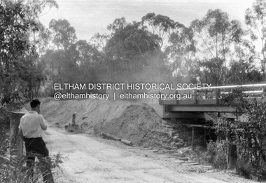 Eltham District Historical Society Inc
Album - Photograph, J.A. McDonald, Henley Road Bridge over Watsons Creek, Sep. 1962
Henley Road Bridge over Watsons Creek Eltham Abutment September 1962Record of various Shire of Eltham infrastructure works undertaken during the period of 1952-1962 involving bridge and road reconstruction projects, sometimes with Eltham Shire Council Project Reference numbers quoted. It was during this period that a number of significant improvements were made to roads and new bridges constructed within the shire that remain in place as of present day (2022). In many situations, the photos provide a tangible visible record of infrastructure that existed throughout the early days of the Shire. The album was put together by or under the direction of the Shire Engineer, J.A. McDonald.H941 stamped on reverse (film processing #)infrastructure, shire of eltham, bridge construction, road construction, bushfires, bend of islands, henley road, henley road bridge, kangaroo ground, oxley bridge, watsons creek, 1962-09 -
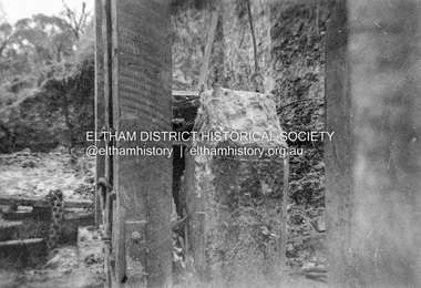 Eltham District Historical Society Inc
Album - Photograph, J.A. McDonald, Dixons Creek Bridge, c. 1962
Dixons Creel Bridge Broken head of pile View looking upstream ? eastRecord of various Shire of Eltham infrastructure works undertaken during the period of 1952-1962 involving bridge and road reconstruction projects, sometimes with Eltham Shire Council Project Reference numbers quoted. It was during this period that a number of significant improvements were made to roads and new bridges constructed within the shire that remain in place as of present day (2022). In many situations, the photos provide a tangible visible record of infrastructure that existed throughout the early days of the Shire. The album was put together by or under the direction of the Shire Engineer, J.A. McDonald.'66' written in pencil1962, bridge construction, dixons creek bridge, dixon's creek road, infrastructure, road construction, shire of eltham -
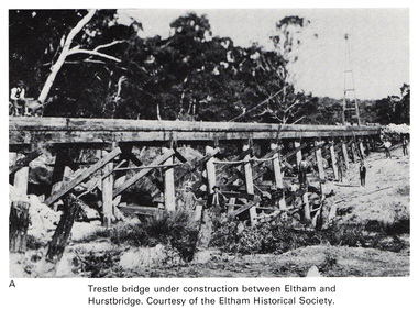 Eltham District Historical Society Inc
Work on paper (Sub-Item) - Photograph, Trestle bridge under construction between Eltham and Hurstbridge
Black and white photograph of the bridge under construction. The line opened at Hurstbridge in 1912.bridge, hurstbridge -
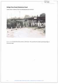 Greensborough Historical Society
Article and Photograph, Bridge at Para Road and Gladstone Road, 2018_
Information and photograph about the railway bridge at Para Road and Gladstone Road Greensborough.This photograph and text was copied from a Facebook site. Members are people who lived in the Greensborough area and share their reminiscences of the area with others. The site is administered by a GHS member but is not officially affiliated with the Society. Any information is the opinion of the contributor. Article and photograph sourced from social media.railway bridge greensborough, gladstone road briar hill, para road greensborough -
 Greensborough Historical Society
Photograph - Digital image, Jan Lewis, From Sondemeyer's looking towards swing bridge and Pope's farm, circa 1958, 1958c
From Sondemeyer's looking towards swing bridge and Pope's farm, circa 1958Digital copy of black and white photographsondemeyers hill, popes farm -
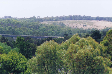 Greensborough Historical Society
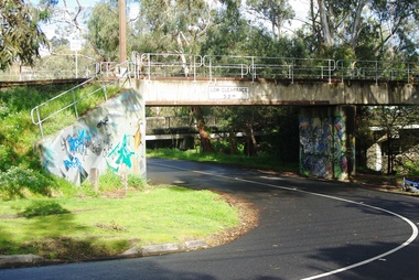
Photograph - Digital image, Frank Solomon, View over Greensborough to Plenty River Drive bridge, 2010c
View over trees to the Greensborough By-pass bridge over Plenty River Drive.Digital copy of colour photographplenty river drive, greensborough bypass -
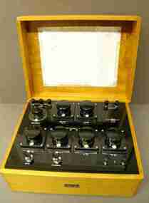 Federation University Historical Collection
Scientific Instrument, Wheatstone Bridge
Wheatstone Bridge, Type WBSRS, 4 Decade. Serial Number 3875. Black panel with terminal posts, selector knobs and switches in a polished wood box with lift-off lid. Circuit diagram photocopy inside the lid. scientific instruments, j.l. williams, wheatstone bridge -
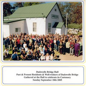 Stawell Historical Society Inc
Photograph, Spielvogel Photographic, Dadswells Bridge Hall
Colour photo of Dadswells Bridge building and gathering of people for centenary of Hall. 2005Colour photo in Folder