Showing 1113 items matching "beach road"
-
 Melbourne Tram Museum
Photograph - Block Mounted Photograph, c1934 original photo, print - c1980
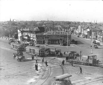
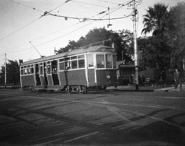
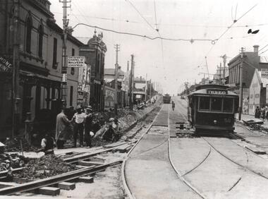
Block mounted photograph of a scene c1934 at St Kilda Junction, featuring re-surfacing of the junction tram track - used on page 3 of the December issue of Bellcord. "St Kilda Junction looking northward as tramway roadworks near completion. Workmen are dispersing gravel to cover recently applied bitumen, perhaps from the tanker (centre). Ballast Motor 11 pushes a ballast trailer ahead of W2 571 to St Kilda Beach and a second car to East Malvern. A horse drawn tower wagon (left), heavy roller (foreground) and private motor vehicles stand by. On the Punt Road corner is a petrol station advertising a then popular brand, Atlantic Ethyl, advertising Ford cars. Segments of the intricate junction overhead and trackwork are visible." 2nd copy added from the Donation by David Webb of the Keith Kings collection - in box 89.trams, tramways, st kilda junction, tower wagon, trackwork, freight tram, ballast motor, trailers, tram 11, tram 571 -
 Melbourne Tram Museum
Photograph - Illustration/s, "Types of Tramcars used in Australian Capital Cities", 1921
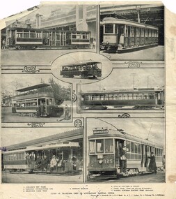
Illustration - from an Australian magazine newspaper or journal titled "Types of Tramcars used in Australian Capital Cities", giving 7 images of tramcars. 1 - Adelaide F201 2 - Sydney O 1480 3 - Brisbane excursion car? 4 - Hobart 21 5 - Perth - large bogie tram 6 - Melbourne cable car set - outside Flinders St Station - North Carlton - St Kilda Beach 7 - MMTB - No. 125, route 18, Burwood destination, with conductor on a footboard. Source of the images unknown.trams, tramways, mmtb, melbourne, cable trams, flinders st, burwood, maximum traction, conductors, route 18, adelaide, sydney, hobart, perth, brisbane, north carlton, tram 125 -
 Melbourne Tram Museum
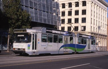
Poster, Yarra Trams, "40 parking spaces", "on your way", "140 Commuters", c2003
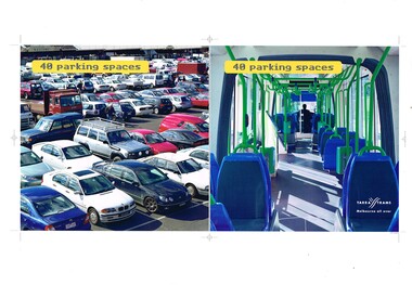
Set of three posters, A3 landscape with motor vehicles or car parks and C class trams, promoting travel by tram. .1 - Titled "40 parking spaces" - show a full car park against the interior of a tram. .2 - titled "In your way" against "on your way" - C class tram - number removed, .3 - titled "140 commuters" = showing Hoddle St Richmond against tram C 3035. Printed by Yarra Trams, possibly as trial posters as have printer registration marks. Have Yarra Trams Melbourne all over logo in the bottom right hand cornerOn rear in ink: .1 - "Brunswick St Melbourne" .2 - "Punt Road Windsor" .4 - "St Kilda Junction"trams, tramways, yarra trams, hoddle st, richmond, route 96, st kilda beach, c class, car parks, tram 3035 -
 Melbourne Tram Museum
Photograph - Albert Road and Clarendon St South Melbourne, Bill Kingsley, 13/10/1971
Set of four black and white photos by Bill Kingsley of trams in South Melbourne: 1 - SW6 895 (Sth Melbourne & St Kilda Beach, Route 12) outbound in Albert Road. Tram has advertisements for Robo 2 min auto car wash, and Norton makes Bear Tape. 2 - W2 639 (Sth Melbourne & St Kilda Beach, Route 12) outbound in Albert Road. Tram has advertisements for Tolleys Brandy. In the background is the former South Melbourne Football ground. 3 - W5 773 (City-Brunswick St, route 12), turning from Albert Road into Clarendon St. Tram has advertisements for Sprint soft drink and HMV sound systems. 4 - Photo of Bill KIngsley's well-known VR Combi van.Yields information about the Albert Road tram servicesSet of four black and white photographs and associated 35mm negatives.Location on the rear of each print.trams, tramways, bill kingsley., albert road, clarendon st, route 12, sw6 class, w5 class, w2 class, tram 895, tram 639, tram 773, vr combi, south melbourne, south melbourne football ground -
 Melbourne Tram Museum
Negative - Copy - L 101 Balaclava Junction Hawthorn Road Caufield, early 1940s
Copy negative of a photograph of L 101 Balaclava Junction Hawthorn Road Caufield, with a destination of Glenhuntly Depot. The tram was fitted with a route number boxes in June 1939, which provides a date era for the tram, but is yet to have its drop centre floor raised. Behind the tram is the shelter at this location along with a sign stating the trams could be taken to Balaclava, St Kilda Beach and Caulfield, along with a tram stop sign and an End Section sign.Yields information about the use of L class trams.Copy negative of a black and white photographtramways, caulfield, l class, tram 101, hawthorn road, shelters, signs, trams -
 Melbourne Tram Museum
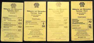
Ephemera - Timetables - MMTB trams - set of 8, Melbourne & Metropolitan Tramways Board (MMTB), 1976
... - Kew - Cotham Road to St Kilda Beach - route 69 - August 1976 6... - Kew - Cotham Road to St Kilda Beach - route 69 - August 1976 6 ...Timetables - provide information on ticketing, fares, and timing points, with a description of the route and a map. Not all services had been allocated a route number at the time. 1 - East Brighton - City and via William St - routes 64, 65, 62 and 61 - July 1976 2 - Malvern (Burke Rd) to City and via Wiliam St - routes 5 and 35 - Oct. 1976 3 - Carnegie - City and via William St - routes 67, 37, and 66 - July 1976 4 - Wattle Parke - City and Camberwell depot - routes 70, 71 and 76 - Sept. 1976 5 - Kew - Cotham Road to St Kilda Beach - route 69 - August 1976 6 - East Preston - via Bourke or La Trobe, and East Brunswick - routes 88, 14, 89. 90, 96, 95, and 97 - Feb. 1976 7 - Toorak - City and via William St - routes 8 and 38 - August 1976 8 - St Kilda Beach and South Melbourne Beach and via William St - routes 15, 16, 53, 55, 1, 2 and 4 - Sept. 1976 Yields information about MMTB tram services during the 1970s. Set of 8 MMTB tram timetables - multifolded printed on yellow paper.timetable, mmtb, wattle park, east brighton, malvern, carnegie, kew, east brunswick, toorak, st kilda beach, south melbourne beach, route 64, route 65, route 62, route 61, roure 5, route 35, route 67, route 37, route 66, route 70, route 71, route 76, route 69, route 88, route 96, route 8, route 38, route 15, route 1, route 2, route 55, route 53 -
 Melbourne Tram Museum
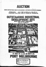
Pamphlet, Geo M Hume, "Auction - Outstanding Industrial development site - Port Melbourne", May. 1982
Draft of a pamphlet - folded A3 sheet for the sale in June 1982 of the former Port Melbourne Bus Depot, near the corner of Bay St and Beach St. Consists of two sheets of 150gsm ? paper bound together with an adhesive tape. A loose sheet showing the layout of the various titles included as well. Note the correction to the owners name from the MMBW to the MMTB. Includes an aerial photo of the site, photos of the buildings, addresses of the block, a site plan, title particular, terms of sale and the Vendors Agent, Geo M Hume.trams, tramways, mmtb, buses, sale of land, port melbourne depot -
 Melbourne Tram Museum
Slide - Set of 7, Keith Caldwell, 12/03/1960 12:00:00 AM
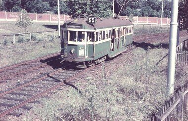
Set of 7 Agfa Colour slide, cardboard mount, by Keith Caldwell of 7 or 12 March 1960 - .1 - W2 227 outbound in Royal Park with the Zoo walls in the background. Destination West Coburg, Route 55. Tram has two adverts which are hard to read. .2 - W2 470 inbound, Domain Road, Route 56 with the Upfield (Fawkner) railway line in the background. Tram has a Remy Martin Brandy advert. .3 - W5 786, as for .2, with an Exide battery advert. .4 - W2 456 as for .2, with an Coca Cola Advert .5 - SW6 965 in bound, showing St Kilda, route 55 with the railway line in the background. Tram has adverts for Band-Aids, Porsche motor cars in Richmond and Singletons? .6 - L 106 - in bound, showing destination of Carnegie, route 4. This would most likely be a Glen Huntly depot doing a late afternoon trip via William St. Has the zoo wall in the background. .7 - W3 655 in bound, showing destination of Carnegie, route 4. This would most likely be a Glen Huntly depot doing a late afternoon trip via William St. Tram has a Remy Martin Brandy advert. Tram running down to the Flemington Road intersection. .1 and .7 have political graffiti or slogans painted onto the zoo walls. examples are" Vote Bryant Out, ?? and the Labor Party? Welfare not warfare out Menzies and Drop Bob today Vote ? Out".1 to .4 - hand stamped "12 Mar '60" .5 to .7 - ditto "& Mar '60" .2 - "W2 Royal Park" .5 - "SW Car Royal Park" .6 - "L Royal Park" .7 - "W3 Royal Park"trams, tramways, royal park, west coburg, route 55, graffiti, domain rd, railways, route 56, w2 class, w5 class, w3 class, l class, st kilda beach, tram 470, tram 227, tram 456, tram 965, tram 655, tram 106, sw6 class, tram 786 -
 Melbourne Tram Museum
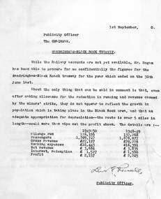
Document - Report, Melbourne & Metropolitan Tramways Board (MMTB), "St Kilda Brighton Beach and Sandringham - Black Rock Tramway", 8 or 9/1950
Set of two memos - carbon copies on quarto paper - from the Publicity Officer to the Chairman regarding the financial returns for both the "St Kilda Brighton Beach and Sandringham - Black Rock Tramway". .1 - dated 24/8/1950 - discussing the financial returns and passengers on both lines. Based on information from the Annual Reports. .2 - dated 1/9/1950 - based on confidential information, insufficient profit to justify and patronage not growing with population growth.Signed or initialled by Lewis Russell.trams, tramways, vr, st kilda brighton, sandringham, black rock, financial statements, costs -
 Melbourne Tram Museum
Map, Melbourne & Metropolitan Tramways Board (MMTB), Set of 15 tram route maps, 1977 to 1979
Series of 15 colour route maps for various tram lines or groups of tram lines for the MMTB. Some have the Transport Information Centre telephone printed on them, others have a label stuck on. Some are finished with a plastic laminate finish on either one or both sides. Show the major cross streets, parks, schools, other tram routes, major stop numbers and railway lines. Two copies of each held unless noted otherwise. .1 - Mont - Albert City - R11/77, shows routes 43. 47. 45. 44 .2 - Malvern, East Malvern, Carnegie and East Brighton Tram Routes (from St Kilda Junction) - R1/79 - shows routes 5, 3, 67, 66, 61, 62 and 64. .3 - Swanston St tram guide - R1/79 - lists all routes and route numbers that branch or cross Swanston St between Grattan St and St Kilda Junction. .4 - St Kilda Rd Tram Routes R12/77 - details South Melbourne Beach, route 1 and route 2 and St Kilda Beach routes 15, 16 and 55 otherwise shows were the various routes branch off St Kilda Road. Copy 1 has "P14909" in pencil in the bottom right hand corner. .5 - Kew - St Kilda Beach - R1/79 - Route 69. .6 - Footscray - Moonee Ponds - R3/81 - Route 82 .7 - Flinders St tram routes - R5/78 - North Balwyn, East Burwood, routes 48, 40, 41, Hartwell, 28, 74 and 75 .8 - William St tram routes - Route 55, 56 and 63 - South Melbourne Depot and Domain. copy 2 has "P14913" in bottom right hand corner. .9 - Toorak Camberwell and Glen Iris tram routes with Camberwell Junction and Malvern Town Hall, R1/79, routes 8, 7, 6, 72 and 73 shown. .10 - Swanston St tram routes - R12/77 - shows all the Swanston St routes, including East Coburg and Moreland. .11 - Bourke St tram routes - R4/77 - East Brunswick Blyth St and East Preston Tyler St and intermediate routes, routes 95, 96, 97, 90, 89 and 88. .12 - as for .11, dated 1/85, showing extension to La Trobe University - has Metropolitan Transit logo. Only 1 copy held. Also shows route 92 and 87. .13 - Batman Ave tram routes - R9/77 - Wattle Park, North Richmond and Prahran - routes 70, 71, 78 and 79. .14 - City route guide - R9/77 - showing all route numbers and destinations that passed through the CBD. .15 - Elizabeth St tram routes - R12/77 - Essendon Airport, West Maribyrnong, North Coburg lines, routes 50, 58, 60, 54, 57, 52. 49, 59, 18, 20 and 19. Copy 1 has "P14905" in pencil in bottom left hand corner.trams, tramways, maps, route guide, route numbers, routes, mont albert, route 43, route 47, route 45, route 44, route 42, malvern burke rd, east preston, carnegie, east brighton, south caulfield, route 5, route 3, route 67, route 62, route 64, route 66, glenhuntly tram depot, swanston st, st kilda rd, south melbourne beach, st kilda beach, route 1, route 2, route 15, route 16, route 55, kew- cotham road, route 69, route 79, route 82, footscray, moonee ponds, flinders st, north balwyn, kew, east burwood, burwood, hartwell, richmond, route 48, route 40, route 41, route 28, route 74, route 75, route 56, route 63, william st, west coburg, toorak, camberwell, glen iris, malvern town hall, route 72, route 73, route 7, route 8, bourke st, route 6, route 95, route 96, route 97, route 90, route 89, route 89, east preston, east brunswick, la trobe university, clifton hill, route 92, route 87, route 70, route 71, route 78, route 79, north richmond, prahran, wattle park, essendon airport, west maribyrnong, north coburg, route 50, route 58, route 60, route 54, route 57, route 52, route 49, route 59, route 18, route 20, route 19, batman ave -
 Melbourne Tram Museum
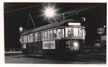
Photograph - Black & White Photograph/s, Dave Macartney, early 1970's
Black and White photograph of W2 282 at the South Melbourne Beach, route 1 terminus, early 1970's, at corner of Victoria Ave and Beaconsfield Parade. Tram has adverts for National batteries, the ABC TV News. In the background is an Mobil Service Station. Photo by Dave Macartney.trams, tramways, south melbourne beach, route 1, w2 class, victoria ave, beaconsfield parade, tram 282 -
 Melbourne Tram Museum
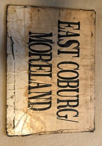
Sign, Melbourne & Metropolitan Tramways Board (MMTB), "Sth Melb Beach" & "East Coburg / Moreland", c1990?
Sign - sheet of plywood, with paper destinations taped to the sheet for an auxiliary destination board - "Sth Melb Beach" & "East Coburg / Moreland" on each side. Appears to be "depot made". Has two small holes in the top corners.trams, tramways, destination indicators, south melbourne beach, east coburg, moreland, auxiliary board -
 Melbourne Tram Museum
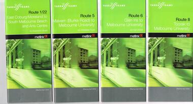
Ephemera - Timetable, Yarra Trams, Set of 22 Yarra Trams timetables, 2003 and 2004
... - Route 78/79 - North Richmond - Prahran or St Kilda Beach - April... 69 - Kew (Cotham Road) to St Kilda Beach - April 2004 .21 ...Set of 22 Yarra Trams timetables, green grey cover with route number on cover, giving details of popular destination, check points, use of Metcards and contact details, tram hire, frequency, a Welcome to Swanston Trams, description of route and route map. .1 - Route 1/22 - East Coburg / Moreland - South Melbourne Beach and Arts Centre - April 2004 - 36 pages. .2 - Route 5 - Malvern (Burke Rd) - University - April 2004 - 32 pages. .3 - Route 6 - Glen Iris - City - April 2004 - 20 pages. .4 - Route 8 - Toorak - April 2004 - 20 pages. .5 - Route 16 - St Kilda Beach - University - April 2004 - 24 pages. .6 - Route 48 - North Balwyn to Docklands - May 2003 - 28 pages .7 - Route 57 - West Maribyrnong - City - April 2004 - 28 pages. .8 - Route 59 - Airport West - City - April 2004 - 32 pages. .9 - Route 64 - East Brighton - University - April 2004 - 28 pages. .10 - Route 67 - Carnegie - City - April 2004 - 20 pages. .11 - Route 70 - Wattle Park - City - May 2003 - 24 pages .12 - Route 72 - Camberwell - University - April 2004 - 28 pages. .13 - Route 78/79 - North Richmond - Prahran or St Kilda Beach - April 2004 - 20 pages .14 - Route 82 - Moonee Pond - Footscray - April 2004 - 20 pages. .15 - Route 109 - Port Melbourne to Box Hill - May 2003 - 28 pages. .16 - Route 112 - Sth Melbourne/St Kilda Beach to West Preston - May 2003 - 44 pages. .17 - Route 3 - East Malvern to Melbourne University - April 2004 - 20 pages .18 - Route 16 - Melbourne University to Kew - Oct. 2004 - 40 pages with fold out map .19 - Route 24 - North Balwyn to LaTrobe St and Route 30 - St Vincent's Plaza to Flinders St via Docklands - 8 pages. .20 - Route 69 - Kew (Cotham Road) to St Kilda Beach - April 2004 .21 - Route 86 - Bundoora to Central Pier - May 2003 .22 - Route 96 - St Kilda Beach to East Brunswick - Sept 2002Some have number notes and notes written inside about changes or errors in ink. See History.trams, tramways, yarra trams, tram services, timetables, route 1, route 3, route 22, route 5, route 6, route 8, route 16, route 24, route 30, route 48, route 57, route 59, route 64, route 67, route 69, route 70, route 72, route 78, route 79, route 86, route 96, route 109, route 112 -
 Melbourne Tram Museum
Newspaper, Head of River Boat races, May. 1934
Head of River Boat races Newspaper clipping and table card for tram scheduling for Head of River Boat Races, Thursday 17 May & Friday 18 May 1934: 1 - Newspaper clipping: outlining daily program of races. 490H x 60W, poor condition, torn and folded 2 - Set of 3 pages of handwritten table cards for Head of River Boat Races. Loading Checks on all routes taken at St Kilda and City Rds, Elsternwick, St Kilda Beach, Toorak, South Melbourne & St Kilda Beaches, east Malvern, Glen Iris, Camberwell, east Malvern @ St Kilda Junction. Loading Checks of Batman Avenue Cars, Glenferrie Rd, Swan & Church Sts, Prahran Cars Swan & Church Ststrams, tramways, instructions, events -
 Melbourne Tram Museum
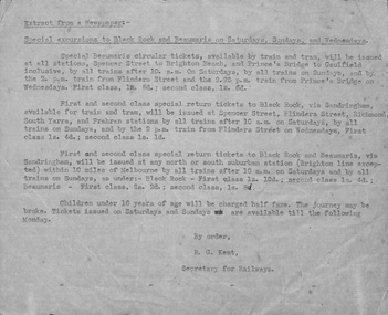
Document - Typed Notes, Special excursions to Black Rock and Beaumaris, c1930
Special excursions to Black Rock and Beaumaris on Saturdays, Sundays and Wednesdays Extract from a newspaper Typed transcript from an unidentified newspaper describing ticketing arrangements for trains and trams for travel to Black Rock and Beaumaris. Special Beaumaris circular tickets, issued at all stations, Spencer St to Brighton Beach, and Prince's Bridge to Caulfield.trams, tramways, tickets, black rock, beaumaris -
 Melbourne Tram Museum
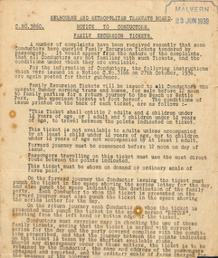
Document - Instruction, Melbourne & Metropolitan Tramways Board (MMTB), Notice to Conductors - Family Excursion Tickets, Jun. 1939
Notice to Conductors - Family Excursion Tickets Instruction C. No. 3860 issued to conductors regarding family excursion tickets. Complaints indicated conductors not aware of use of this ticket. C. No. 3166 was issued 27 October 1936 previously relates to this instruction.Stamped "Malvern 23 Jun 1939" in top right cornertrams, tramways, ticket, fares, conductors, excursions, wattle park, beach -
 Melbourne Tram Museum
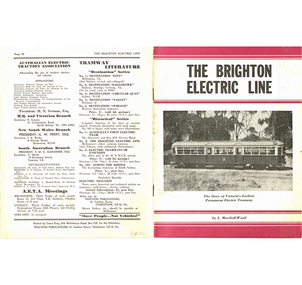
Book, Leon Marshall-Wood, "The Brighton Electric Line", 1958
Book - 20 pages including card covers - the history of the Brighton Electric Line by Leon Marshall-Wood, published 1958, 2nd edition. Gives a brief history of the electric tramway operated by the Victorian Railways between St. Kilda Station and the Brighton Beach railway station, that commenced operation in 1905. Published by Traction Publications. Has details of the AETA on the back cover and listing of some publications. See Reg Item 2062 for the 1st edition and 1351 for the 3rd Edition.trams, tramways, vr, melbourne, brighton, st kilda -
 Melbourne Tram Museum
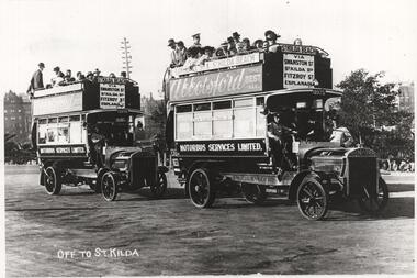
Photograph - Black & White Photograph/s, late 1910's
Photograph, Black and White, of two Tilling Stevens double deck buses Registered Nos 13975 and 13976, Nos. 1 and 2 at the Southern end of Princes Bridge, c1914. Operated by Motorbus Services Limited. Have destination of St Kilda Beach via Swanston St, St Kilda Rd Fitzroy St Esplanade. On the side of the bus is an advertisement for "Abbotsford Ale". Print has the title "Off to St Kilda". See Reg Item 5276 for a photo of 10 company buses.In ink on the rear: "Melbourne - Tilling Stevens double deck buses Registered No. s 13975 and 13976, Nos. 1 and 2 at the Southern end of Princes Bridge, Probably 1910's." KSK print numbers LWR-10 and in pencil H2601.trams, tramways, buses, private bus companies, tilling stevens -
 Melbourne Tram Museum
Ephemera - Timetable/s, Public Transport Victoria (PTV), 2019
Set of 24 digital timetables generally applicable from 1-1-2019. Image files are htd3520iRx - x being the route number. Route 1 - East Coburg - South Melbourne Beach Route 3 and 3A - Melbourne University - East Malvern - and via St Kilda Beach - two timetables for each Route 5 - Melbourne University - Malvern Route 6 - Melbourne University - Glen Iris Route 11 - West Preston - Victoria Harbour Docklands Route 12 - Victoria Gardens - St Kilda Route 16 - Melbourne University - Kew Via St Kilda Route 19 - North Coburg - Flinders St Route 30 - St Vincent's Plaza - Etihad Stadium Docklands - though the stadium was renamed Marvel after Marvel comics by Disney during May 2018. Old name retained, but appears to becoming just Docklands Stadium on Yarra trams website when this item added. Route 35 - City Circle - NOT Published. Route 48 - North Balwyn - Victoria Harbour Docklands Route 55 - West Coburg - Domain Interchange Route 57 - West Maribyrnong - Flinders St Route 58 - Toorak to Route 59 - Airport West - Flinders St Route 64 - East Brighton - Melbourne University Route 67 - Carnegie - Melbourne University Route 70 - Wattle Park - Waterfront City Docklands Route 72 - Camberwell - Melbourne University Route 75 - Vermont South - Etihad Stadium Docklands Route 78 - North Richmond - Balaclava via Prahran Route 82 - Footscray - Moonee Ponds Route 86 - Bundoora RMIT - Waterfront City Docklands Route 96 - East Brunswick - St Kilda Beach Route 109 - Box Hill - Port Melbournetrams, tramways, timetables, yarra trams, route 1, route 3, route 5, route 6, route 8, route 11, route 12, route 16, route 19, route 30, route 48, route 55, route 57, route 58, route 59, route 64, route 67, route 70, route 72, route 75, route 78, route 82, route 86, route 96, route 109 -
 Melbourne Tram Museum
Slide - Set of 2, David Verrier, 14/10/1967 12:00:00 AM
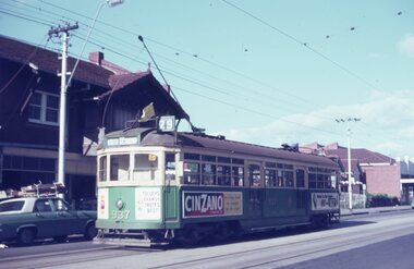
Set of two Agfa colour slide, white blue plastic mount. Photograph by David Verrier. .1 - W6 937 on a route 79 in Balaclava Road, St Kilda, adjacent to the St Kilda Town Hall. The tram has a Cinzano advert and others. .2 - SW6 same location, route 79 to St Kilda Beach. Photos taken 14/10/1967.In ink: "4/10/67 937 in front, St Kilda Town Hall", In ink: "4/10/67 885 in front, St Kilda Town Hall"trams, tramways, balaclava rd, st kilda beach, route 79, sw6 class, w6 class, tram 885, tram 937 -
 Melbourne Tram Museum
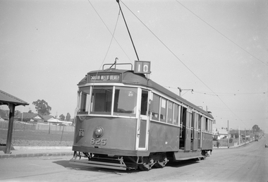
Negative - Set of 2, Ellis Collection, c1940
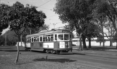
Set of two Negatives (120) of W5 825 at the West Preston Terminus, Gilbert Road, before Regent St. c1940. Note the "T" shaped lights on the tram - these were a red reflector - see page 104 of Destination City 5. Tram has the destination of South Melbourne Beach, route 10 and has a run number of P20 showing. Hi Res image filed in the dbtext/hawthtramcoll/Large Images/htd3606i1 and i2Large.jpgtrams, tramways, west preston, gilbert rd, w5 class, gilbert rd, route 10, tram 825 -
 Melbourne Tram Museum
Photograph - Black & White Photograph/s, Melbourne & Metropolitan Tramways Board (MMTB), 1926
Black and white photograph of MMTB No. 58 in Wellington St. St Kilda, about to enter St Kilda Junction and continue to St Kilda beach via Fitzroy St St Kilda, late 1925 or early 1926 - Wellington St electric line opened 27/12/1925. Note the sign on the left hand pole about travel to Malvern and St Kilda Beach, the workmen and that another tram has left heading outwards. On the right hand side is part of a sign advising people to catch cars to the Esplanade. Photo from the Collection of the Department of Infrastructure now with the Public Records Office - image number H102. Note: this photo is now out of copyright and was not an original VR photograph, but one copied from another source and collected as their Heritage series. See Image 3673i2 for a digital image of the card photograph at the PRO on 7/1/2019 that this photograph comes from. Further notes from Rod Atkins: Note the Electrical box at base of the pole on left hand side of the photo. No section insulators yet as power would have been stretched from Dandenong Road / Chapel Street right through to Fitzroy Street to run the first services. Great shot of the "H" car. Malvern bound is a another Californian combo car, but with original destination boxes and PPTT style "No" on the left side of the apron but cant make out the number.Has Department of Infrastructure copy right stamp on rear and number "H 102" in ink on rear and "2-3"trams, tramways, mmtb, st kilda junction, wellington st, trackwork, st kilda beach, tram 58 -
 Melbourne Tram Museum
Photograph - Black & White Photograph/s, Melbourne & Metropolitan Tramways Board (MMTB), Jan. 1926
Black and white photograph of the conversion of the intersection of Domain Road, St Kilda Road, Domain Junction from cable tram to electric tram. Shows the Toorak Road Tram remaining trackwork, the temporary track for the electric trams with 276 inbound with the destination of North Coburg and another W class tram outbound to St Kilda Beach. Note the temporary platform and the temporary board crossing. Has "The Foundation Company Engineers and Contractors" sign in the view and the petrol? powered roller. Photo from the Collection of the Department of Infrastructure now with the Public Records Office - image number H101. Note: this photo is now out of copyright and was not an original VR photograph, but one copied from another source and collected as their Heritage series.Has Department of Infrastructure copy right stamp on rear and number "H513" in ink on rear and "2-5".trams, tramways, swanston st, cable trams, trackwork, new tramway, flinders st, conversion -
 Melbourne Tram Museum
Slide - Set of 9, Colin Rough, 29/04/2003 12:00:00 AM
Set of 9, 35mm Tecnodia white plastic mount slides of trams in Spencer St Melbourne, just to the north of Collins St, 29/4/2003 by Colin Rough. All with the Batman Hill Hotel in the background. All in Yarra Trams livery unless noted otherwise. .1 - B 2101, St Kilda Beach, route 96, advertising Shipwrecked the Ride at the Aquarium. .2 - B 2041, northbound route 96, advertising Bridgestone tyres. .3 - B 2108, as for .1, all over advertising for Uncle Tobys .4 - ditto .5 - B 2080 as for .1, advertising Headache pills .6 - B 2036, City Latrobe St, route 75 .7 - B 2023, East Burwood route 75 .8 - ditto .9 - C 3021, route 96.On front written on a label "Yarra Trams Spencer St, Melbourne 29/4/03" and the tram number.trams, tramways, spencer st, yarra trams, b class, route 96, route 75, c class, tram 2101, tram 2041, tram 2108, tram 2080, tram 2036, tram 2023, tram 3021 -
 Melbourne Tram Museum
Slide - Set of 21, Colin Rough, 29/04/2003 12:00:00 AM
Set of 21, 35mm Tecnodia white plastic mount slides by Colin Rough of trams in St Kilda Road, near the Arts Centre on 29/4/2003. All in M>Tram livery unless noted otherwise. (Were the D's doing driver training?) .1 - Z3 116, all over advertising for Vodaphone, with the Arts Centre buildings in the background. .2 - Z3 122, University .3 - Z3 122, ditto .4 - Z3 139, East Brighton .5 - Z3 195. Arts Centre .6 - Z3 195, Moreland .7 - B 2066 East Coburg, Route 1 - in PTC livery. .8 - B 2104 - South Melbourne Beach, Route 1 .9 - D1 3501, Malvern Route 5 .10 - ditto, but not in service. .11 - D1 3503, University .12 - D1 3503, no destination, followed by another D. .13 - D1 3506, not in service .14 - ditto .15 - ditto followed by an Z class .16 - D1 3508 in all over advertising for Cold Shot Beer, followed by Z2 101 .17 - ditto .18 - D1 3511 - not in service .19 - ditto .20 - D1 3519 (written on slide), not in service or in a colour scheme. Noted as being new. .21 - dittoOn front written on a label "M>Tram, St Kilda Road, Melbourne 29/4/03" and the tram number.trams, tramways, st kilda rd, m>tram, route 22, arts centre, z3 class, b class, route 1, route 5, tram 116, tram 122, tram 139, tram 195, tram 2066, tram 2104, tram 3501, tram 3503, tram 3505, tram 3506, tram 3508, tram 3511, tram 3519, tram 101, d1 class, z2 class -
 Melbourne Tram Museum
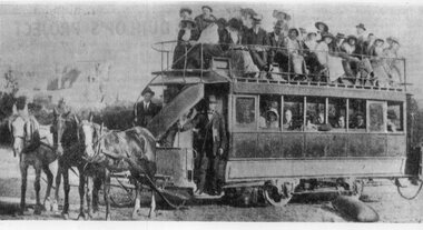
Photograph - Black & White Photograph/s, 1890s
Black and White Photograph of a Beaumaris horse tram. 8 window, double deck, three horses. Keith notes that the 3rd horse was needed on beach weather days See also Reg Item 3157 for another photograph of a horse tram. See Keith's notes on the rear of the photograph for more information. Printed on Kodak Paper.On rear in ink a description - see image i2 and KSK number "S-A-535"trams, tramways, beaumaris horse tram, horse trams -
 Melbourne Tram Museum
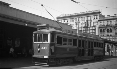
Negative, Wal Jack, c1951
Black and white negative, by Wal Jack, of VR 40 at St Kilda Station, mid 1950's. Has adverts for Robur Tea/Coffee on the side. Taken at the same time as Reg Item 5099. Has the George Hotel in the background. Tram behind 53 could be No. 40, see Reg Item 5102.trams, tramways, brighton beach, vr trams, st kilda brighton, st kilda railway station, tram 40 -
 Melbourne Tram Museum
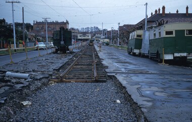
Slide, Keith Kings, 12/09/1959 12:00:00 AM
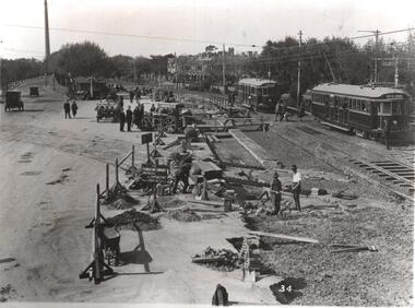
Colour slide, Kodak, fawn cardboard of track laying for the new South Melbourne / St Kilda Beach terminus in Park St, for the closing of the section of track into Mary St and Beaconsfield Parade. Has an early tracked excavator, parked on the road that has been broken up. Shows new track laid on timber sleepers with former wartime Austerity buses along side the road. Photo taken at the corner of Mary St 12/9/1959. Preliminary overhead work has been undertaken. Slide Number K(c)(292)Extensive handwriting on rear in ink and that it was photographed at 1/60 at f4.5.trams, tramways, st kilda, mary st, beaconsfield parade, south melbourne, new track, park st st kilda -
 Melbourne Tram Museum
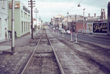
Slide - Set of 3, Keith Caldwell, 25/04/1964 12:00:00 AM
Set of three Agfa colour slides, blue / white plastic mounts, photos by Keith Caldwell March 1963 of the reconstruction of tram track in Church St Richmond. .1 - Looking south from near William and Church Streets. In the background is Bryant & May buildings and Flexpax (McFarlane Bros) and Penfolds wines on a hoarding. .2 - ditto with W2 397 Southbound, route 79 to St Kilda Beach (has adverts for Milk and Coffey Ford), passing W5 730 to North Richmond. Has adverts for Stillwells of Kew and Drambuie. .3 - ditto showing the nature of the construction of the old track being replaced. 25/4/1964In ink "Relay Chapel St 25.4.64"trams, tramways, church st, richmond, w2 class, w5 class, route 79, trackwork, temporary track, tram 397, tram 730 -
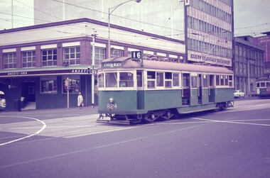 Melbourne Tram Museum
Slide, Keith Caldwell, 20/03/1966 12:00:00 AM
Agfa colour blue white plastic mount, photo by Keith Caldwell of W5 824 southbound in Swanston St at Franklin St with the Ansett ANA buildings in the background. Tram has the destination of St Kilda Beach, route 16. 20/3/1966In ink "W5 20 iii 66"trams, tramways, w5 class, route 16, swanston st, franklin st, south melbourne, tram 824