Showing 23056 items matching "creek"
-
 Stawell Historical Society Inc
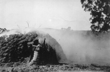
Photograph, Charcoal Burning in Fyans Creek area with part of the kiln formation
Charcoal Burning in Fyans Creek area. Shows part of kiln formation.stawell -
 Stawell Historical Society Inc
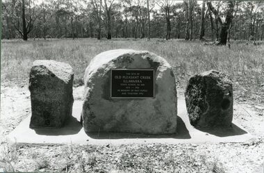
Photograph, Pleasant Creek / Illawarra State School Number 1681 Plaque -- Old Site
School Site Old Pleasant Creek State School No 1681 / Illawarrastawell education -
 Stawell Historical Society Inc
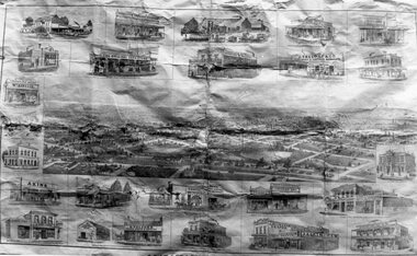
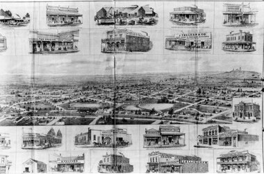
Drawing, Newspaper Supplement, “Pleasant Creek News” from the P.C. News Supplement 1888 -- Sketch's
Supplement “Pleasant Creek News” from P.C. News Supplement 1888stawell businesses -
 Stawell Historical Society Inc
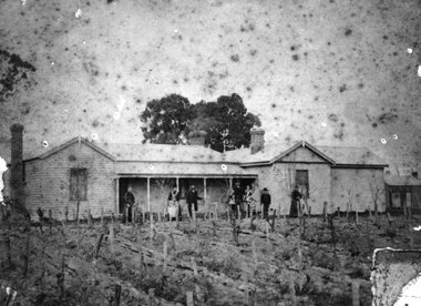
Photograph, “Cheshire Park” Homestead at Greens Creek -- Home of Mr Charles Frederick Proctor
“Cheshire Park” Homestead - Greens Creek. Home of Charles Frederick Proctor.stawell -
 Stawell Historical Society Inc
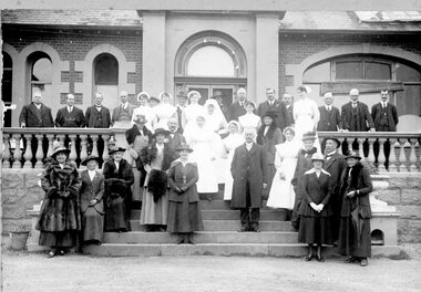
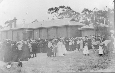
Photograph, Pleasant Creek Hospital Doctors, Nurses & Committee on front steps of hospital
Pleasant Creek Hospital Doctors. Nurses & Committee on front steps of hospital stawell -
 Ringwood and District Historical Society
Photograph, C of E jambed on bridge over Mullum Creek, W'dyte Rd. Ringwood 1924
Written on back of photograph, "C of E jambed on bridge over Mullum Creek, W'dyte Rd. 1924." Typed below another copy: "Moving Church of England, Ringwood. Stuck on bridge over Mullum Creek in Warrandyte Rd. 1924". Written on backing sheet, "Church of England being moved from C/r Pratt Street and Maroondah H'way to rear post office via Warrandyte Rd., Reynolds Av. and Ringwood Street." -
 Ringwood and District Historical Society
Photograph, Ringwood, Mullum Mullum Creek, east side. Warrandyte Road Bridge. 1986
Written on backing sheet, "Bridge, Mullum Rd. Completed May 1987." Writing on back of photograph reads, "Aug., 1986. Ringwood, Mullum Mullum Creek, east side. Warrandyte Road Bridge". -
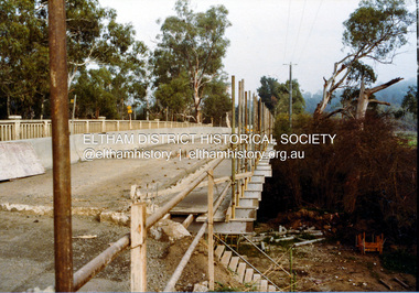
 Eltham District Historical Society Inc
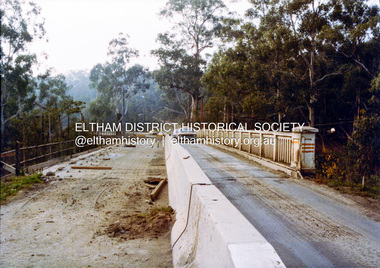
Photograph, Ruth H. Pendavingh, Widening of Main Road Bridge over the Diamond Creek, Eltham, 1984c
Three colour photographs of the construction work of the widening works of the bridge over the Diamond Creek, Eltham, near Lower Eltham Park Victoria. The bridge re-opened on October 25, 1984. (EDHS Chronology of known local events 1835- early 2000) eltham, main road, main road bridge, bridges, construction, diamond creek (river) -
 Eltham District Historical Society Inc
Photograph, Ruth H. Pendavingh, Widening of Main Road Bridge over the Diamond Creek, Eltham, 1984c
Three colour photographs of the construction work of the widening works of the bridge over the Diamond Creek, Eltham, near Lower Eltham Park Victoria. The bridge re-opened on October 25, 1984. (EDHS Chronology of known local events 1835- early 2000) eltham, main road, main road bridge, bridges, construction, diamond creek (river) -
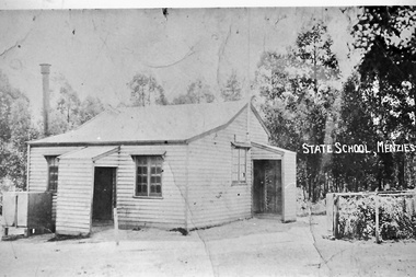 Southern Sherbrooke Historical Society Inc.
Photograph, Menzies Creek Primary School
Menzies Creek primary School opened on 15th April 1882. The front entrance by the square water tank was used by the teacher to gain access to the residence, and the children entered the classroom by the side entrance. The building was destroyed in November 1935 in a fire caused by a workman's blowtorch. -
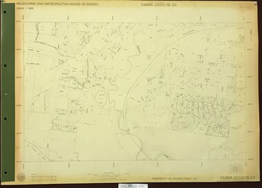 Greensborough Historical Society
Map, Melbourne and Metropolitan Board of Works. Survey Division, MMBW, Yarra 2500 / 15.23. Diamond Creek Reserve, 1978_02
Melbourne and Metropolitan Board of Works. Yarra 2500 [base map] 15.23. Hurstbridge. Municipality of Diamond Valley 257. Prominent streets include: Challenger Street, James Cook Drive and Ryans Road / Main Street. Features include the Diamond Creek and Diamond Creek Reserve.MMBW Map in 1:2500 [scale] series. Cream parchment with green tape reinforcing on edges and punched holes on left edge.mmbw, melbourne and metropolitan board of works, shire of diamond valley, diamond creek - maps -
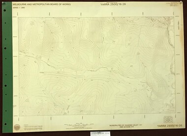 Greensborough Historical Society
Map, Melbourne and Metropolitan Board of Works. Survey Division, MMBW, Yarra 2500 / 16.26. Diamond Creek, Broadgully Road, 1978_07
Melbourne and Metropolitan Board of Works. Yarra 2500 [base map] 16.26. Diamond Creek, Broad Gully Road. Municipalities of Diamond Valley 257 and Eltham 238. Prominent streets include: Wadeson Road, Broad Gully Road and Glenhaven Road. Features include the Diamond Creek.MMBW Map in 1:2500 [scale] series. Cream parchment with green tape reinforcing on edges and punched holes on left edge.mmbw, melbourne and metropolitan board of works, shire of diamond valley, diamond creek - maps -
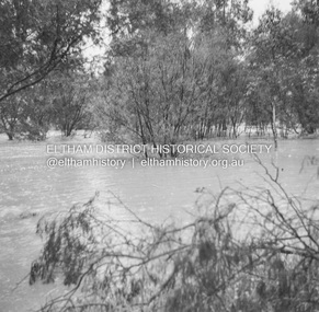 Eltham District Historical Society Inc
Album - Photograph, J.A. McDonald, Eltham-Diamond Creek Road, 21 Oct. 1953
18 October 1956 Flooding on downstream line from Diamond Creek sideRecord of various Shire of Eltham infrastructure works undertaken during the period of 1952-1962 involving bridge and road reconstruction projects, sometimes with Eltham Shire Council Project Reference numbers quoted. It was during this period that a number of significant improvements were made to roads and new bridges constructed within the shire that remain in place as of present day (2022). In many situations, the photos provide a tangible visible record of infrastructure that existed throughout the early days of the Shire. The album was put together by or under the direction of the Shire Engineer, J.A. McDonald.infrastructure, road construction, shire of eltham, bridge construction, eltham north, floods, floodwater, glen park bridge, 1956-10-18, diamond creek (creek), eltham, railway parade, wattletree road, wattletree road bridge -
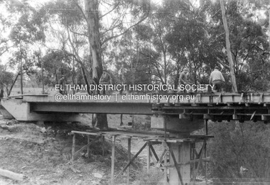 Eltham District Historical Society Inc
Album - Photograph, J.A. McDonald, Henley Road Bridge over Watsons Creek, Aug. 1962
Henley Road Bridge over Watsons Creek Eltham Abutment August 1962Record of various Shire of Eltham infrastructure works undertaken during the period of 1952-1962 involving bridge and road reconstruction projects, sometimes with Eltham Shire Council Project Reference numbers quoted. It was during this period that a number of significant improvements were made to roads and new bridges constructed within the shire that remain in place as of present day (2022). In many situations, the photos provide a tangible visible record of infrastructure that existed throughout the early days of the Shire. The album was put together by or under the direction of the Shire Engineer, J.A. McDonald.H941 stamped on reverse (film processing #)infrastructure, shire of eltham, bridge construction, road construction, bushfires, 1962-08, bend of islands, henley road, henley road bridge, kangaroo ground, oxley bridge, watsons creek -
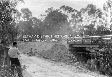 Eltham District Historical Society Inc
Album - Photograph, J.A. McDonald, Henley Road Bridge over Watsons Creek, Sep. 1962
Henley Road Bridge over Watsons Creek Eltham Abutment September 1962Record of various Shire of Eltham infrastructure works undertaken during the period of 1952-1962 involving bridge and road reconstruction projects, sometimes with Eltham Shire Council Project Reference numbers quoted. It was during this period that a number of significant improvements were made to roads and new bridges constructed within the shire that remain in place as of present day (2022). In many situations, the photos provide a tangible visible record of infrastructure that existed throughout the early days of the Shire. The album was put together by or under the direction of the Shire Engineer, J.A. McDonald.H941 stamped on reverse (film processing #)infrastructure, shire of eltham, bridge construction, road construction, bushfires, bend of islands, henley road, henley road bridge, kangaroo ground, oxley bridge, watsons creek, 1962-09 -
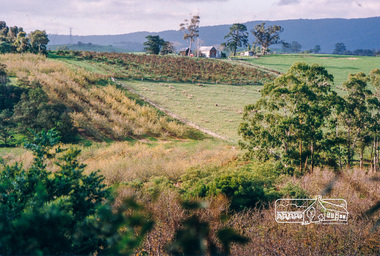
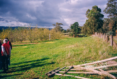
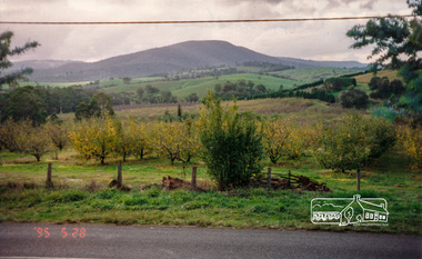 Eltham District Historical Society Inc
Photograph, Bettina Woodburn, Apted's Orchard, 864 Cottles Bridge-Strathewen Rd, Arthurs Creek, 28/05/1995
Autumn Excursion to St Andrews, Arthurs Creek and Strathewen, 28 May 1995.Colour photographactivities, apted's orchard, arthurs creek, cottles bridge-strathewen rd -
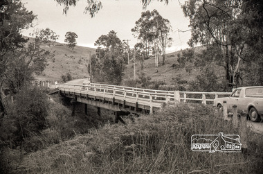 Eltham District Historical Society Inc
Negative - Photograph, Russell Yeoman, Cottles Bridge over Diamond Creek, Cottles Bridge-Strathewan Road, Cottlesbridge, c.1970
Cottles Bridge over Diamond Creek, Cottles Bridge-Strathewen Road, CottlesbridgeRoll of 35mm black and white negative film, 4 of 7 stripsIlford HP4bridge, cars, cottles bridge, cottles bridge-strathewen road, diamond creek (creek) -
 Eltham District Historical Society Inc
Photograph, Fred Mitchell, Clouds over the Diamond Creek Trail, 23 May 2014, 23/05/2014
The structure with an orange tarpaulin is the plant nursery attached to the Diamond Creek Men's Shed.Digital copy of colour photographfred mitchell collection, 2014, diamond creek trail -
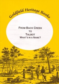 Ballarat Heritage Services
Book, Marie Kau, From Back Creek to Talbot
From Back Creek to Talbot was published by BHS Publishing and written by Marie Kau. Yellow soft covered booklet on Talbot, Victoria.talbot, back creek -
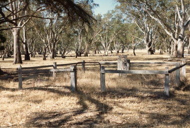 Stawell Historical Society Inc
Photograph, Mokepilly Station Cemetery on Mokepilly property Mount William Creek -- Coloured
Two photographs of Mokepilly Station Cemetery on Mokepilly property Mount William Creek.stawell -
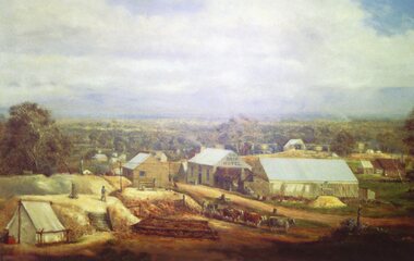 Stawell Historical Society Inc
Photograph, Photo of Mr Will Rees's painting of The Reef Hotel Pleasant Creek with a Bullock team in front
Photo of Will Rees painting of The Reefs Hotel Pleasant Creek with Bullock team in front.stawell -
 Stawell Historical Society Inc
Drawing, Framed Supplement “Pleasant Creek News” from P.C. News Supplement 1888 -- Sketch
Framed Supplement “Pleasant Creek News” from P.C. News Supplement 1888stawell businesses -
 Stawell Historical Society Inc
Photograph, Pleasant Creek -- Stawell Hospital residents gathered for Official Opening of the Syme Ward
Pleasant Creek. Stawell Hospital residents gathered for Official Opening of Syme Wardstawell hospital medical -
 Stawell Historical Society Inc
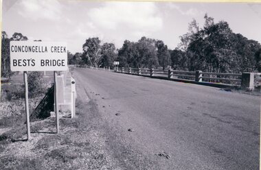
Photograph, Best’s Bridge over Concongella Creek in Great Western with plaques -- 3 Photos
Three photographs of Best’s Bridge over Concongella Creek. Great Western with plaques.stawell -
 Stawell Historical Society Inc
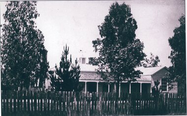
Photograph, "Whitehall House" -- MrJohn Hutching’s First Home in Greens Creek
John Hutching’s First Home. Greens Creek before destroyed by fire 1877stawell -
 Greensborough Historical Society
Map, Melbourne and Metropolitan Board of Works. Survey Division, MMBW, Yarra 2500 / 16.23. Diamond Creek, 1978_02
Melbourne and Metropolitan Board of Works. Yarra 2500 [base map] 16-23. Diamond Creek. Parish of Nillumbik 3310. Municipalities of Diamond Valley 257 and Eltham 238. Prominent streets include: Phipps Crescent, Bishop Avenue, and Reynolds Road. Includes the former Diamond Creek Technical School.MMBW Map in 1:2500 [scale] series. Cream parchment with green tape reinforcing on edges and punched holes on left edge.mmbw, melbourne and metropolitan board of works, shire of diamond valley, diamond creek - maps -
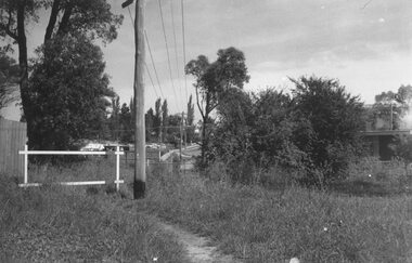 Ringwood and District Historical Society
Photograph, Looking to Adelaide St. from Reynolds Ave. Ringwood (across Mullum Creek) 1973. Site of bridge washed away in floods 1931. Infant Welfare Centre (Dr. Hewitts) on right
Black and white photographCatalogue card reads, "Looking to Adelaide St. from Reynolds Ave. (across Mullum Creek) 1973. Site of bridge washed away in floods 1931. Infant Welfare Centre (Dr. Hewitts) on right."