Showing 1027 items matching "disasters"
-
 Mt Dandenong & District Historical Society Inc.
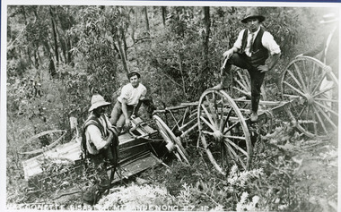
Photograph, The Wagonette Disaster 27th December 1911, 1911
This accident occurred at Devil's Elbow where now the Old Coach Road and Jasper Road meet at a cliff face. John Lundy-Clarke wrote a ballad about the mishap, probably combining fact and fancy. The wagonette was returning from an excursion to the Brooklyn Guest House in Montrose. Apparently only the horses were killed in the accident. See 'The Brooklyn Dray". The photograph shows local men inspecting the wreckage. (Not passengers as they were injured).devil's elbow, kalorama, john lundy-clarke, wagonette -
 Tramways/East Melbourne RSL Sub Branch - RSL Victoria Listing id: 27511
Book, George Forty & John Duncan et al, THE FALL OF FRANCE (Disaster in the West 1939-40), 1990
isbn: 1-871876-15-x -
Moorabbin Air Museum
Book - AIR DISASTER CANBERRA, ANDREW TINK, 2013
-
Moorabbin Air Museum
Book - DISASTER IN THE DANDENONG, MACARTHUR JOB, DISASTER IN THE DANDENONGS, 2008
-
 Queenscliffe Maritime Museum
Uniform - Brassard
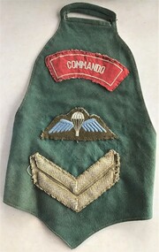
A brassard is a fabric armband holding any fabric badges, unit logos or rank insignia and is worn over fatigues or army tunics.Similar to ones worn by commandos involved in Rip disaster of 1960Army commando jungle green brassard with badge, unit logo and stripes"Commando" in white on red background badge; White parachute on blue wings on green base paratrooper badge; 2 khaki chevrons corporal stripes brassard, commando -
 Queenscliffe Maritime Museum
Uniform - Beret
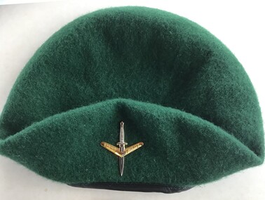
On the evening of February 17, 1960, 74 peacetime commandos in army boats set off on a training exercise from Point Lonsdale to Point Nepean, simulating a raid. The weather was calm at Point Lonsdale on a midweek evening 50 years ago, but 50 years ago weather forecasts were not yet reliable. By nightfall a massive storm came through and all hell broke loose. Soon, three young Victorians were dead and more than 70 others were rescued from huge seas in Bass Strait.Green commando beret similar to ones worn by commandos involved in Rip Disaster of 1960Commando beret (green) with unit insigniaUnit insignia: "Strike Swiftly"commandos, beret -
 Queenscliffe Maritime Museum
Functional object - Paddles
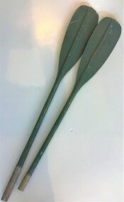
In 1960 seventy-four commandos from 2 Commando Company left Point Lonsdale at 6pm on February 17 to cross The Rip in an exercise raid on the Portsea officer school. Shortly after departing, a strong tide caught the raiding party and pushed them out to sea through The Rip, where 10-metre waves capsized many of the kayaks and amphibious vehicles. Many of the men were picked up by larger rescue boats, only to be overturned once again in the heavy seas. Warrant Officer George Drakopolous and the driver of his amphibious DUKW, Private Eddie Meyer, both drowned as their vehicle sank. Eight of the commandos were rescued in Bass Strait after being picked up by an Italian ship, the Toscana. Commando Roger Wood helped others board the Toscana safely but was washed off a rope ladder by a monster wave and into the sea. His body was never found. It remains one of Australia's least-known peacetime military tragedies.One of the later disasters around the Rip between Points Nepean and Lonsdale. The 'Queenscliffe' lifeboat turned out to search for survivors without success Paddles from a Mk3 foldaboat used in ill fated commando training exercise in 1960the rip disaster, kayaks, oars -
Queenscliffe Maritime Museum
Photograph - Photograph, Goorangai crew
The "Goorangai" sank when struck by the outward bound passenger ship "Duntroon". The 3 officers and 21 sailors went down with her including Lt. Commander Boyle who was in command 20/11/1940A photograph of officers and crew and their autographs taken circa 1940Mounted photograph and autographs of the crew of the minesweeper "HMAS Goorangai"hmas goorangai, goorangai disaster, wwii, port phillip- -
 Queenscliffe Maritime Museum
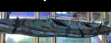
Vehicle - Kayak, Commandos
The remarkable story when 74 soldiers fought in vain to save the lives of their mates off Portsea as 3 soldiers died. Tragically, Privates Roger Wood and Edward Meyer, and Warrant Officer George "Taffy" Drakopoulos, died. Please Note: "The Rip" is also known as "The Heads", which is a dangerous stretch of water connecting Port Phillip Bay and Bass Strait. This is the only entrance for all shipping into Port Phillip Bay and to and from the Port of Melbourne, Victoria, Australia.Kayak of a similar type as those used during the ill-fated army exercise with loss of life in the rip.rip disaster, commandos, kayak, military history - army -
Kew Historical Society Inc
Journal, Kew Historical Society, Newsletter No.141, December 2022
Planning and [natural] disasters / David White pp1-2. History News [New walking tours; Application for Grants funding; Social media; The Collection; New member] / p3. Onward Upward: a history of Kew East Primary School / Desley Reid pp4-5. Kew Scout District swimming sports / Brad Miles p5. As it happened ... / p5. Leopoldine Mimovich: sculptor, etcher and painter / Felicity Renowden pp7-9. Kew as it might have been / David White pp9-11. Application for grants funding / Judith Voce p11. Membership Renewals/Applications / p12.Published quarterly since 1977, the newsletters of the Kew Historical Society contain significant research by members exploring relevant aspects of the Victorian and Australian Framework of Historical Themes. Frequently, articles on people, places and artefacts are the only source of information about an aspect of Kew, and Melbourne’s history.non-fictionPlanning and [natural] disasters / David White pp1-2. History News [New walking tours; Application for Grants funding; Social media; The Collection; New member] / p3. Onward Upward: a history of Kew East Primary School / Desley Reid pp4-5. Kew Scout District swimming sports / Brad Miles p5. As it happened ... / p5. Leopoldine Mimovich: sculptor, etcher and painter / Felicity Renowden pp7-9. Kew as it might have been / David White pp9-11. Application for grants funding / Judith Voce p11. Membership Renewals/Applications / p12. kew historical society (vic.) -- periodicals., kew historical society (vic.) -- newsletters, kew historical society (vic.) -- journals, melbourne: report of the metropolitan town planning commission 1929 -
Kew Historical Society Inc
Collection, Floods in North Kew (Series), 1929–1934
Flooding of the Yarra Valley, including that section of the Yarra bordering Kew and Kew East in the north and west of the municipality, was a regular occurrence. Extreme flood events of the Yarra River are recorded to have occurred in 1891, 1901, 1916, 1923 and 1934. The Municipality of Kew's response to these floods was to enact planning decisions restricting residential development in flood prone areas following the floods of 1916, 1921 and 1934. While floods continued after the development of the Upper Yarra Reservoir (construction 1948-57), the regularity and extent of these inundations diminished. Natural disasters had an impact on the development and settlement of Melbourne and its suburbs. Flooding in the Melbourne region was a regular event in the nineteenth and for most of the twentieth centuries. Changes in the impact of natural disasters could occur due to a number of factors. This collection of small snapshots, mostly taken from Kellett Grove in North Kew, provide provenanced evidence of flooding in the area before the development of the unnatural flood barrier that is the Eastern Freeway.Collection of 16 monochrome photographs, annotated on verso by different hands, of the flooding of the River Yarra in North Kew in the third and fourth decades of the twentieth century [1920s & 1930s]. Individual photos include the dates of different floods. Many of the photos were taken from the rear of 8 Kellett Grove; a house still extant in 2023yarra river -- north kew, floods -- yarra valley, floods -- north kew, floods -- 1929, floods -- 1934, natural disasters -- kew -
 Kew Historical Society Inc
Photograph - Flooding of the Yarra River in North Kew, 1934
North Kew, now divided between Kew and Kew East, bordered the Yarra River. As such, it was a region subject to flooding in the Yarra Valley. Development beyond this point (ie Kellett Grove) was limited by the City of Kew's planning regulations. Prior to urban development, the area since European settlement and the first land sales in the district in the 1840s, had been used for dairy farming. Small sepia snapshot taken from the river ramp of a house at 8 Kellett Grove, in what was then known as North Kew. The point of view is from a backyard looking towards Fairfield. Beyond the fence line are two almost submerged houses. A number of people are in a motor driven boat midstream. Fairfield at this period, (ie 1934) was noted for its limited river side development. Verso: 2/12/34 / TAKEN FROM OUR RAMPyarra river -- north kew, floods -- yarra valley, floods -- north kew, floods -- 1929, floods -- 1934, natural disasters -- kew -
 Kew Historical Society Inc
Photograph - Flooding of the Yarra River in North Kew, 1934
North Kew, now divided between Kew and Kew East, bordered the Yarra River. As such, it was a region subject to flooding in the Yarra Valley. Development beyond this point (ie Kellett Grove) was limited by the City of Kew's planning regulations. Prior to urban development, the area since European settlement and the first land sales in the district in the 1840s, had been used for dairy farming. Small sepia snapshot taken from the back yard of a house at 8 Kellett Grove, in what was then known as North Kew. The point of view is from a backyard looking towards Fairfield. Floodwaters have submerged the fence and a clothes line. Verso: BACKYARD NTH. KEWyarra river -- north kew, floods -- yarra valley, floods -- north kew, floods -- 1934, natural disasters -- kew -
 Kew Historical Society Inc
Photograph - Flooding of the Yarra River in North Kew, 1934
North Kew, now divided between Kew and Kew East, bordered the Yarra River. As such, it was a region subject to flooding in the Yarra Valley. Development beyond this point (ie Kellett Grove) was limited by the City of Kew's planning regulations. Prior to urban development, the area since European settlement and the first land sales in the district in the 1840s, had been used for dairy farming. Small sepia snapshot taken from the back yard of a house at 8 Kellett Grove, in what was then known as North Kew. The point of view is from a backyard looking towards Fairfield. Verso: 8 KELLETT GROVEyarra river -- north kew, floods -- yarra valley, floods -- north kew, floods -- 1934, natural disasters -- kew -
 Kew Historical Society Inc
Photograph - Flooding of the Yarra River in North Kew, 1934
North Kew, now divided between Kew and Kew East, bordered the Yarra River. As such, it was a region subject to flooding in the Yarra Valley. Development beyond this point (ie Kellett Grove) was limited by the City of Kew's planning regulations. Prior to urban development, the area since European settlement and the first land sales in the district in the 1840s, had been used for dairy farming. Small sepia snapshot taken from the back yard of a house at 8 Kellett Grove, in what was then known as North Kew. The point of view is from a backyard looking towards Fairfield. Verso: OUR BACKYARD 8 KELLETT GROVEyarra river -- north kew, floods -- yarra valley, floods -- north kew, floods -- 1934, natural disasters -- kew -
 Kew Historical Society Inc
Photograph - Flooding of the Yarra River in North Kew, 1934
North Kew, now divided between Kew and Kew East, bordered the Yarra River. As such, it was a region subject to flooding in the Yarra Valley. Development beyond this point (ie Kellett Grove) was limited by the City of Kew's planning regulations. Prior to urban development, the area since European settlement and the first land sales in the district in the 1840s, had been used for dairy farming. Small sepia snapshot of floodwaters taken from near Kellett Grove, in what was then known as North Kew. The point of view is from a backyard looking towards Fairfield. In the foreground ar two men in a rowboat.Verso: OUR BACKYARD / Stamped 3 163yarra river -- north kew, floods -- yarra valley, floods -- north kew, floods -- 1934, natural disasters -- kew -
 Kew Historical Society Inc
Photograph - Flooding of the Yarra River in North Kew, 1934
North Kew, now divided between Kew and Kew East, bordered the Yarra River. As such, it was a region subject to flooding in the Yarra Valley. Development beyond this point (ie Kellett Grove) was limited by the City of Kew's planning regulations. Prior to urban development, the area since European settlement and the first land sales in the district in the 1840s, had been used for dairy farming. Small sepia snapshot of floodwaters taken from near Willsmere Road, in what was then known as North Kew. The point of view is looking towards Fairfield. In the foreground are two figures viewing a group in a rowboat in the middle of the flooded river. Semi-submerged street lighting indicates that entire streets had been. overwhelmed by the flood waters. Verso: WILLSMERE ROAD NORTH KEW / Stamped 3 163yarra river -- north kew, floods -- yarra valley, floods -- north kew, floods -- 1934, natural disasters -- kew, willsmere road -
 Kew Historical Society Inc
Photograph - Flooding of the Yarra River in North Kew, 1934
North Kew, now divided between Kew and Kew East, bordered the Yarra River. As such, it was a region subject to flooding in the Yarra Valley. Development beyond this point (ie Kellett Grove) was limited by the City of Kew's planning regulations. Prior to urban development, the area since European settlement and the first land sales in the district in the 1840s, had been used for dairy farming. Small sepia snapshot of floodwaters in North Kew. The point of view is of two houses belonging to local families that were surrounded by floodwater. Verso: HYATTS HOUSE / WILLSMERE ROAD / Stamped 3 163yarra river -- north kew, floods -- yarra valley, floods -- north kew, floods -- 1934, natural disasters -- kew, willsmere road -
 Kew Historical Society Inc
Photograph - Flooding of the Yarra River in North Kew, 1934
North Kew, now divided between Kew and Kew East, bordered the Yarra River. As such, it was a region subject to flooding in the Yarra Valley. Development beyond this point (ie Kellett Grove) was limited by the City of Kew's planning regulations. Prior to urban development, the area since European settlement and the first land sales in the district in the 1840s, had been used for dairy farming. Small sepia snapshot of floodwaters in North Kew, from the rear of 8 Kellett Grove. Verso: OUR BACKYARD / Stamped 52yarra river -- north kew, floods -- yarra valley, floods -- north kew, floods -- 1934, natural disasters -- kew, willsmere road -
 Kew Historical Society Inc
Photograph - Grandfather and granddaughter in the yard of 8 Kellett Grove, Kew, 1934
North Kew, now divided between Kew and Kew East, bordered the Yarra River. As such, it was a region subject to flooding in the Yarra Valley. Development beyond this point (ie Kellett Grove) was limited by the City of Kew's planning regulations. Prior to urban development, the area since European settlement and the first land sales in the district in the 1840s, had been used for dairy farming. Vivid photograph contrasting domestic life and relationships with natural disasters such as the flood of 1934.Small sepia snapshot of a grandfather and granddaughter sitting in the backyard of 8 Kellett Grove, North Kew, with the floodwaters stretching behind them.Verso: GRANDDAD AND I IN BACKYARDyarra river -- north kew, floods -- yarra valley, floods -- north kew, floods -- 1934, natural disasters -- kew, willsmere road -
 Kew Historical Society Inc
Photograph - Submerged houses in River Avenue, North Kew, 1934
North Kew, now divided between Kew and Kew East, bordered the Yarra River. As such, it was a region subject to flooding in the Yarra Valley. Development beyond this point (ie Kellett Grove) was limited by the City of Kew's planning regulations. Prior to urban development, the area since European settlement and the first land sales in the district in the 1840s, had been used for dairy farming. Vivid photograph contrasting domestic life and relationships with natural disasters such as the flood of 1934.Small sepia snapshot of two submerged houses belonging to local families in River Avenue, North Kew, during the 1934 floods. The view is presumably from near Kellett Grove looking north towards Fairfield.Verso: COES & HYATTS ROOF / RIVER AVENUE / Stamped: 6414yarra river -- north kew, floods -- yarra valley, floods -- north kew, floods -- 1934, natural disasters -- kew -
 Kew Historical Society Inc
Photograph - Flooding of the Yarra River in North Kew, 1934
North Kew, now divided between Kew and Kew East, bordered the Yarra River. As such, it was a region subject to flooding in the Yarra Valley. Development beyond this point (ie Kellett Grove) was limited by the City of Kew's planning regulations. Prior to urban development, the area since European settlement and the first land sales in the district in the 1840s, had been used for dairy farming. Vivid photograph contrasting domestic life and relationships with natural disasters such as the flood of 1934.Small sepia snapshot of the donors grandfather rescuing the family dog's kennel from rising floodwaters at the rear of 8 Kellett Grove, North Kew, .Verso: DAD SECURING NIPPY'S DOG KENNEL / Stamped 6414yarra river -- north kew, floods -- yarra valley, floods -- north kew, floods -- 1934, natural disasters -- kew -
 Kew Historical Society Inc
Photograph - Flooding of the Yarra River in North Kew, 1934
North Kew, now divided between Kew and Kew East, bordered the Yarra River. As such, it was a region subject to flooding in the Yarra Valley. Development beyond this point (ie Kellett Grove) was limited by the City of Kew's planning regulations. Prior to urban development, the area since European settlement and the first land sales in the district in the 1840s, had been used for dairy farming. .Small sepia snapshot of a local family's house in what was then River Avenue, North Kew being surrounded by floodwaters.Verso: THE SIDE OF RYANSyarra river -- north kew, floods -- yarra valley, floods -- north kew, floods -- 1934, natural disasters -- kew -
 Kew Historical Society Inc
Photograph - Flooding of the Yarra River in North Kew, 1934
North Kew, now divided between Kew and Kew East, bordered the Yarra River. As such, it was a region subject to flooding in the Yarra Valley. Development beyond this point (ie Kellett Grove) was limited by the City of Kew's planning regulations. Prior to urban development, the area since European settlement and the first land sales in the district in the 1840s, had been used for dairy farming. .Small sepia snapshot of what was then River Avenue, North Kew submerged by floodwaters.The photo was taken in the vicinity of 8 Kellett Grove, North Kew. Verso: TAKEN FROM OUR STREET JUST SEE A BIT OF RYAN'S FENCE / 1934yarra river -- north kew, floods -- yarra valley, floods -- north kew, floods -- 1934, natural disasters -- kew -
 Kew Historical Society Inc
Photograph - Flooding of the Yarra River in North Kew, 1934
North Kew, now divided between Kew and Kew East, bordered the Yarra River. As such, it was a region subject to flooding in the Yarra Valley. Development beyond this point (ie Kellett Grove) was limited by the City of Kew's planning regulations. Prior to urban development, the area since European settlement and the first land sales in the district in the 1840s, had been used for dairy farming. .Small sepia snapshot of the devastation caused by the 1934 flood.The photo was taken in the vicinity of Kellett Grove, North Kew and includes the roof of Chipperfield's Boathouse as well as other local houses.Verso: THIS IS CHIPPERFIELD'S BOAT SHEDS & COES & WILLIAMS TAKEN FROM OUR STREET / 1934yarra river -- north kew, floods -- yarra valley, floods -- north kew, floods -- 1934, natural disasters -- kew, chipperfields boathouse -
 Clayton RSL Sub Branch
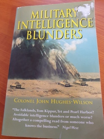
soft cover non-fiction book, Military Intelligence Blunders, 1999
an historical look at military intelligence mishapsIn this controversial, eye-opening book, a long-serving professional military intelligence officer examines and analyzes the mistakes in military judgment that have resulted in some of the major catastrophes in the air, at sea, and on the battlefield since the crushing defeat of Napoleon at Waterloo in 1815. Colonel John Hughes-Wilson not only explores how events have conspired to cause disasters in modern military history but also demonstrates why -- and the reason more often than not lies in the failure of politicians and seasoned generals alike to understand and appreciate fully the value of crucial intelligence information. Hughes-Wilson shows how, for one instance, American bureaucratic bungling and inter-service rivalries collaborated with the Japanese in their devastating attack on Pearl Harbor -- despite the fact that the US was monitoring Japan's top-secret radio traffic -- and he reveals why, for another, the Viet Cong's Tet Offensive of 1968 took the world's most technologically advanced army completely by surprise. In Hitler's Berlin as in Saddam Hussein's Baghdad, this book discloses the lapses, errors, miscalculations, and under-estimations of military intelligence that have shaped our wars and defined our timessoft cover non fiction book -
 National Communication Museum
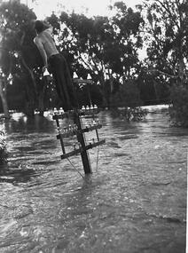
Photograph (item) - Floodwater pole repair, Sydney Press, June 1952
Postmaster-General's Department telegraph linesman, Chris Byrnes, received a British Empire Medal for bravery and devotion to duty for his response to the flooding at Darlington Point, New South Wales, in June 1952. As E Henderson, then Acting Director of Posts and Telegraphs recalled, the town's "communication lines were menaced by floodwaters" when the nearby Murrumbidgee River flooded. In order to retain communication to the town, Chris Byrnes, a Postmaster-General's Department employee of over 13 years, acted in the "best traditions of the service" (E Henderson). An eye witness, recorded in the Murrumbidgee Irrigator newspaper on June 27 1952, described Byrne’s efforts: "An interesting incident was witnessed when a Leeton post office linesman swam through flood waters to reach a telegraph post which had been washed out by the flood…With a rope tied around his waist, one end of which was held by other members of the linesmen's gang, Chris Byrne swam through the flood water…to release the trunk lines from the post." An eye witness, recorded in the Murrumbidgee Irrigator newspaper on June 27 1952, described Byrne’s efforts: "An interesting incident was witnessed when a Leeton post office linesman swam through flood waters to reach a telegraph post which had been washed out by the flood…With a rope tied around his waist, one end of which was held by other members of the linesmen's gang, Chris Byrne swam through the flood water…to release the trunk lines from the post."darlington point, murrumbidgee river, pmg, postmaster-general, linesman, flooding, natural disaster, emergency -
 Lilydale RSL Sub Branch
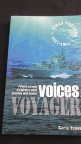
Book, Carla Evans, Voices from Voyager, 1999
Personal accounts of Australia's worst naval disaster.Booknon-fictionPersonal accounts of Australia's worst naval disaster. -
Tarnagulla History Archive
Issue of Newsrail magazine: Article about train derailment at Tarnagulla, 2018
David Gordon Collection. Article on p332railways, transport, disasters, accidents -
Bass Coast Shire Council - Art Collection
Artwork, other - In the Shadow of Disaster - The Wife, Noel Counihan
AustraliaLinocutSigned